-
 James Stewart's route between Lake Malawi and Lake Tanganyika, 1880Royal Geographical Society (RGS)Series: LondonRoyal Geographical Society (RGS), James Stewart's route between Lake Malawi and Lake Tanganyika, 1880£ 125.00
 -
Map of the Route of the R.G.S. East African Expedition to Lakes Nyassa & Tanganyika, 1880Royal Geographical Society (RGS)Series: LondonRoyal Geographical Society (RGS), Map of the Route of the R.G.S. East African Expedition to Lakes Nyassa & Tanganyika, 1880£ 225.00
-
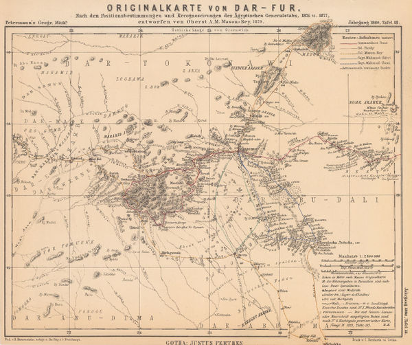
Justus Perthes, Darfur, Sudan, 1880£ 68.00
-
Justus Perthes, Equatorial East Africa, 1881£ 675.00
-
Royal Geographical Society (RGS), Map of the Mozambique Coast, 1882£ 195.00
-
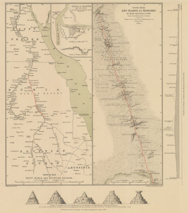
Royal Geographical Society (RGS), Sketch Map of Egypt, Nubia and Egyptian Sudan, 1884£ 145.00
-
Edward Stanford, A Map of the Nile during the Siege of Khartoum, 1884£ 345.00
-
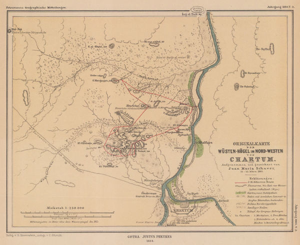
Justus Perthes, Khartoum region, 1884£ 125.00
-
Royal Geographical Society (RGS), Large scale map of Mozambique, 1885£ 495.00
-
European Territorial claims on the coats of the Red Sea, 1885Royal Geographical Society (RGS)Series: LondonRoyal Geographical Society (RGS), European Territorial claims on the coats of the Red Sea, 1885£ 155.00
-
Royal Geographical Society (RGS), Mt Kilimanjaro, 1885£ 675.00
-
Scottish Geographical Society (SGS), Stanley's Emin Pasha Expedition, 1886£ 395.00
-
J.G. Bartholomew, Central Africa, 1887£ 42.00
-
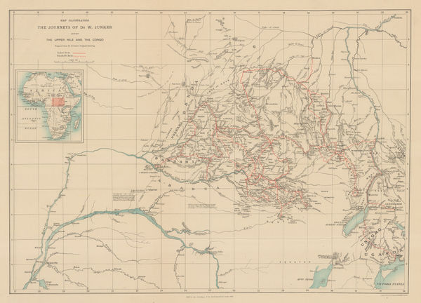
Royal Geographical Society (RGS), Junker's Travels in Congo & South Sudan, 1887£ 245.00
-
Mr. C.S.Smiths Journeys near Mombasa and from Kilwa to the Rovuma, 1887Royal Geographical Society (RGS)Series: LondonRoyal Geographical Society (RGS), Mr. C.S.Smiths Journeys near Mombasa and from Kilwa to the Rovuma, 1887£ 88.00
-
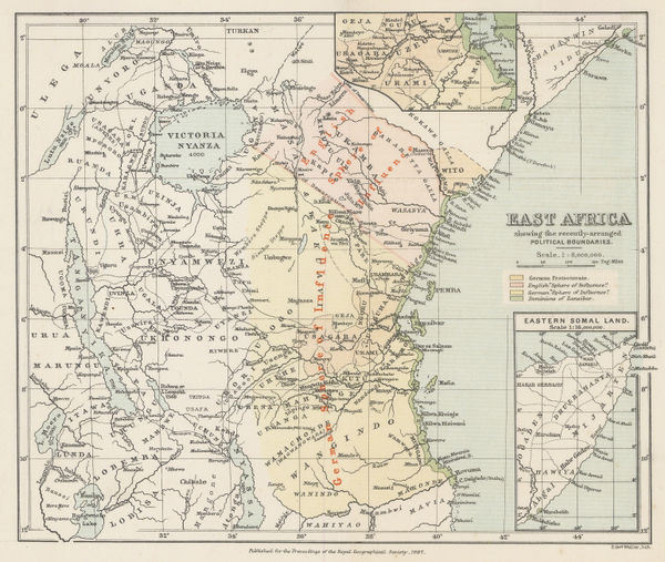
Royal Geographical Society (RGS), East Africa, 1887£ 545.00
-
Royal Geographical Society (RGS), Headwaters of the Congo and Nile Rivers, 1887£ 98.00
-
Map of Mr. F.C. Selous' Routes in the Matabele and Mashuna Countries, 1888Royal Geographical Society (RGS)Series: LondonRoyal Geographical Society (RGS), Map of Mr. F.C. Selous' Routes in the Matabele and Mashuna Countries, 1888£ 195.00
-
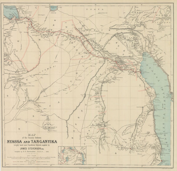
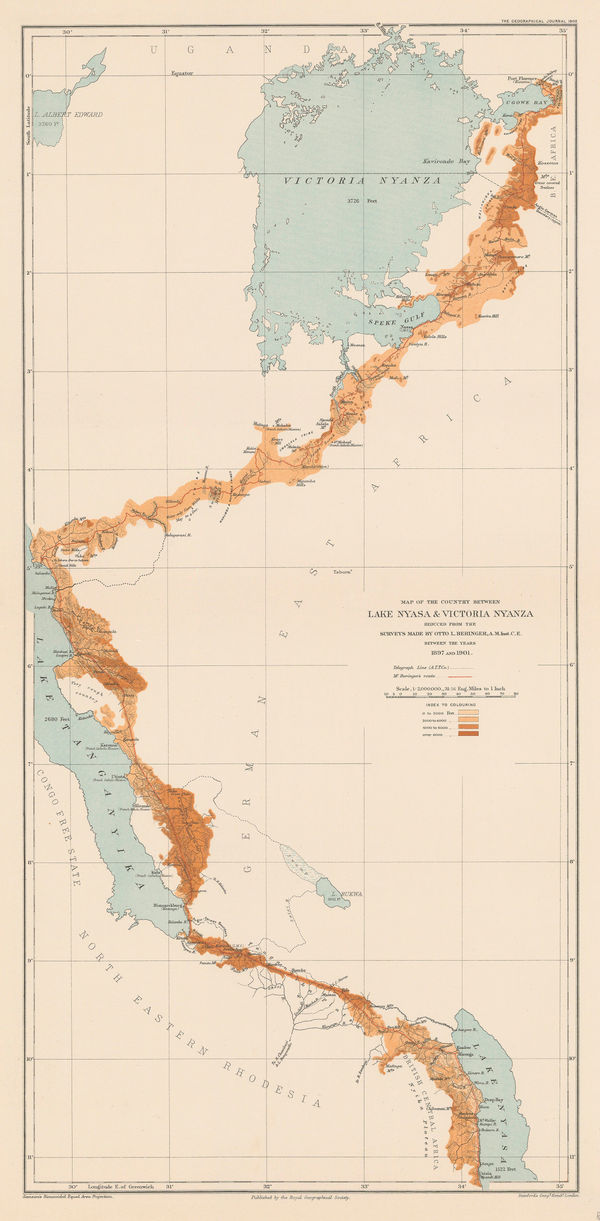
Scottish Geographical Society (SGS), Lake Malawi (Nyassa) to Lake Tanganyika, 1888£ 545.00
-
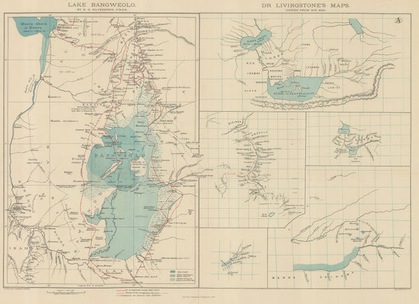
Royal Geographical Society (RGS), Livingstone's maps of Lake Bangweulu, Zimbabwe, 1889£ 145.00
-
Arbuckle Brothers Company, Central Africa, 1889£ 95.00
-
Eastern Africa between the Rovuma and Zambesi Rivers, 1890Royal Geographical Society (RGS)Series: LondonRoyal Geographical Society (RGS), Eastern Africa between the Rovuma and Zambesi Rivers, 1890£ 495.00
-
The Stevenson Road from Lake Malawi to Lake Tanganyika, 1890Scottish Geographical Society (SGS)Series: LondonScottish Geographical Society (SGS), The Stevenson Road from Lake Malawi to Lake Tanganyika, 1890£ 275.00
-
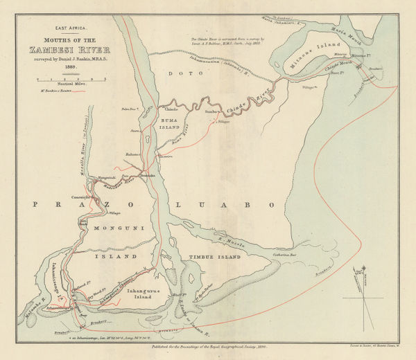
Royal Geographical Society (RGS), Mouths of the Zambesi River, 1890£ 88.00
-
Scottish Geographical Society (SGS), Stanley's Emin Pasha Expedition, 1890£ 775.00
-
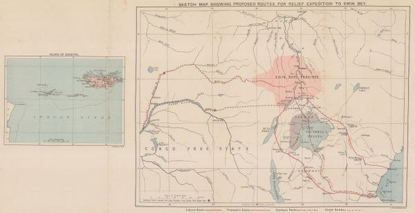
Sketch Map of the Route of the Emin Pasha Relief Expedition, 1890Royal Geographical Society (RGS)Series: LondonRoyal Geographical Society (RGS), Sketch Map of the Route of the Emin Pasha Relief Expedition, 1890£ 325.00
-
Scottish Geographical Society (SGS), Political Sketch-Map of Central Africa, 1890£ 595.00
-
Justus Perthes, Mount Kilimanjaro, 1890£ 645.00
-
George W. Bacon, Bacon's Large-Print Map of South Africa, 1890 c.£ 775.00
-
Royal Geographical Society (RGS), Uganda & Western Kenya, 1891£ 185.00
-
Royal Geographical Society (RGS), The Progress of Exploration in East Africa, 1891£ 395.00
-
Imperial British East Africa (Kenya, Tanzania, Uganda), 1892Royal Geographical Society (RGS)Series: LondonRoyal Geographical Society (RGS), Imperial British East Africa (Kenya, Tanzania, Uganda), 1892£ 545.00
-
German missionary expeditions in north Malawi and southwest Tanzania, 1892Justus PerthesSeries: GothaJustus Perthes, German missionary expeditions in north Malawi and southwest Tanzania, 1892£ 68.00
-
Royal Geographical Society (RGS), Western Uganda, 1892£ 325.00
-
Royal Geographical Society (RGS), Malawi and Zambia, 1893£ 145.00
-
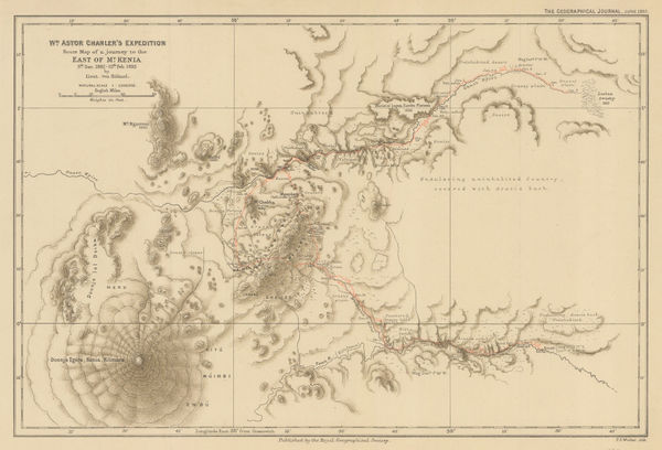
Wm. Astor Chanler's Expedition Route Map of a Journey to the East of Mt. Kenia, 1893Royal Geographical Society (RGS)Series: LondonRoyal Geographical Society (RGS), Wm. Astor Chanler's Expedition Route Map of a Journey to the East of Mt. Kenia, 1893£ 160.00
-
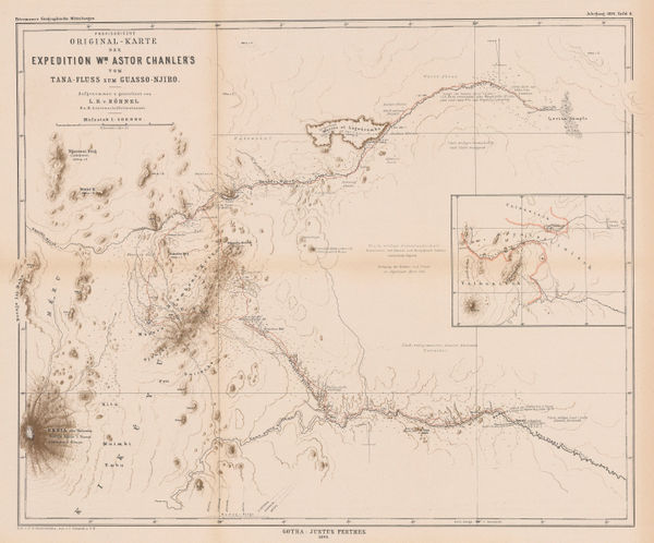
Justus Perthes, William Astor Chanler's Expedition to Mount Kenya, 1893£ 285.00
-
Royal Geographical Society (RGS), Mombasa-Victoria Lake Railway, 1893£ 545.00
-
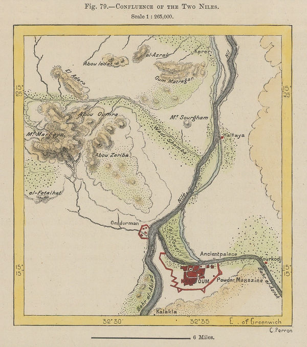
Jean Jacques Élisée Reclus, Confluence of the Two Niles, 1894£ 38.00
-
Map of Part of British and German East Africa including the British Protectorate of Uganda, 1894War OfficeSeries: LondonWar Office, Map of Part of British and German East Africa including the British Protectorate of Uganda, 1894£ 1,650.00
-
Royal Geographical Society (RGS), Map of Part of East Africa, 1895£ 190.00
-
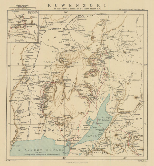
Royal Geographical Society (RGS), Rwenzori Mountains, Congo - Uganda border, 1895£ 185.00
-
Justus Perthes, Kenya, Uganda and Tanzania, 1895£ 895.00
-
Justus Perthes, Mt Kenya to Mt Kilimanjaro, 1896£ 195.00
-
Royal Geographical Society (RGS), Zambia & Victoria Falls, 1897£ 145.00
-
Royal Geographical Society (RGS), Uganda & Western Kenya, 1897£ 385.00
-
Royal Geographical Society (RGS), Eastern Zambia, 1898£ 135.00
-
Royal Geographical Society (RGS), Lake Turkana (Rudolf), Kenya, 1898£ 125.00
-
Royal Geographical Society (RGS), Uganda and western Kenya, 1899£ 265.00
-
Royal Geographical Society (RGS), Survey map between Lakes Tanganyika and Malawi, 1899£ 295.00
-
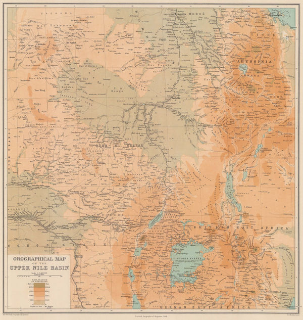
Scottish Geographical Society (SGS), Orographical Map of the Upper Nile Basin, 1899£ 195.00
-
Royal Geographical Society (RGS), Mombasa to Lake Victoria, Kenya, 1899£ 255.00
-
Map to Illustrate Explorations in North East Africa, 1900Royal Geographical Society (RGS)Series: LondonRoyal Geographical Society (RGS), Map to Illustrate Explorations in North East Africa, 1900£ 325.00
-
F Bianconi, Southern Africa during the Boer War, 1900£ 495.00
-
Royal Geographical Society (RGS), The First European Ascent of Mount Kenya, 1900£ 375.00
-
Land Journey from Nasser to the Uganda Railway at Lake Nakuro, 1902Royal Geographical Society (RGS)Series: LondonRoyal Geographical Society (RGS), Land Journey from Nasser to the Uganda Railway at Lake Nakuro, 1902£ 185.00
-
Royal Geographical Society (RGS), Rwanda, Burundi, Tanzania and Uganda, 1902£ 195.00
-
Royal Geographical Society (RGS), Uganda, 1902£ 525.00
-
Royal Geographical Society (RGS), Uganda and Kenya, 1903£ 425.00
-
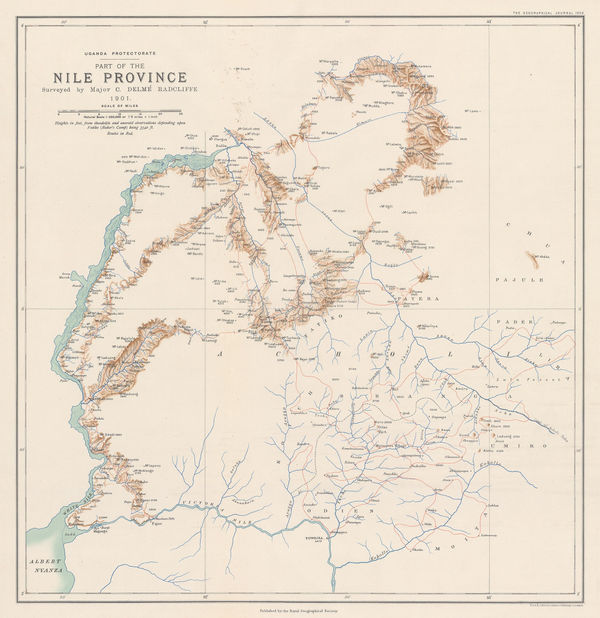
Royal Geographical Society (RGS), Northwest Uganda & the White Nile, 1903£ 225.00
-
Royal Geographical Society (RGS), Sketch Map of Western Uganda, 1904£ 145.00
-
Geographical Section, General Staff (GSGS), Kilimanjaro, 1905£ 895.00
-
Royal Geographical Society (RGS), Uganda - Tanzania Border Commission, 1905£ 145.00
-
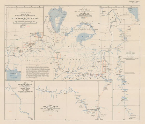
Across Central Africa from Nigeria to the Red Sea, 1907Royal Geographical Society (RGS)Series: LondonRoyal Geographical Society (RGS), Across Central Africa from Nigeria to the Red Sea, 1907£ 195.00
-
Royal Geographical Society (RGS), Victoria Nyanza to Mt. Kilimanjaro, 1907£ 445.00
-
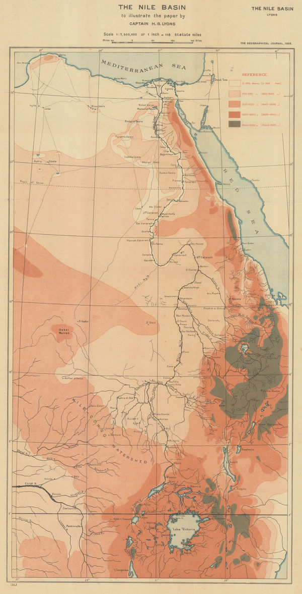
Royal Geographical Society (RGS), Orographical map of the Nile Basin, 1908£ 195.00
-
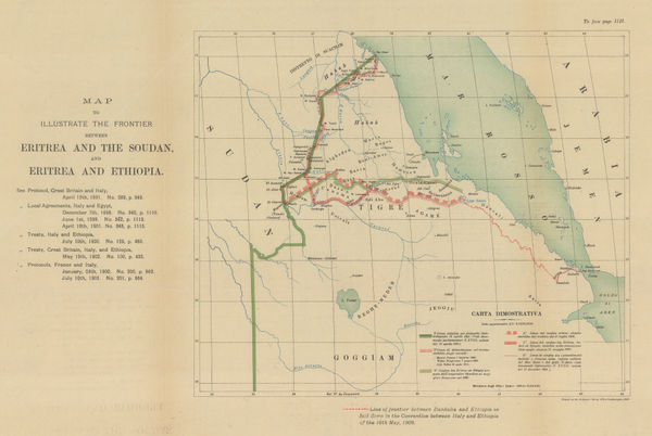
Edward Hertslet, Map of the Frontier between British East Africa and Abyssinia, 1909£ 225.00
-
Royal Geographical Society (RGS), Uganda - Congo Border Commission, 1909£ 325.00
-
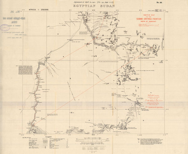
Edward Hertslet, Egyptian Sudan, 1909£ 145.00
-
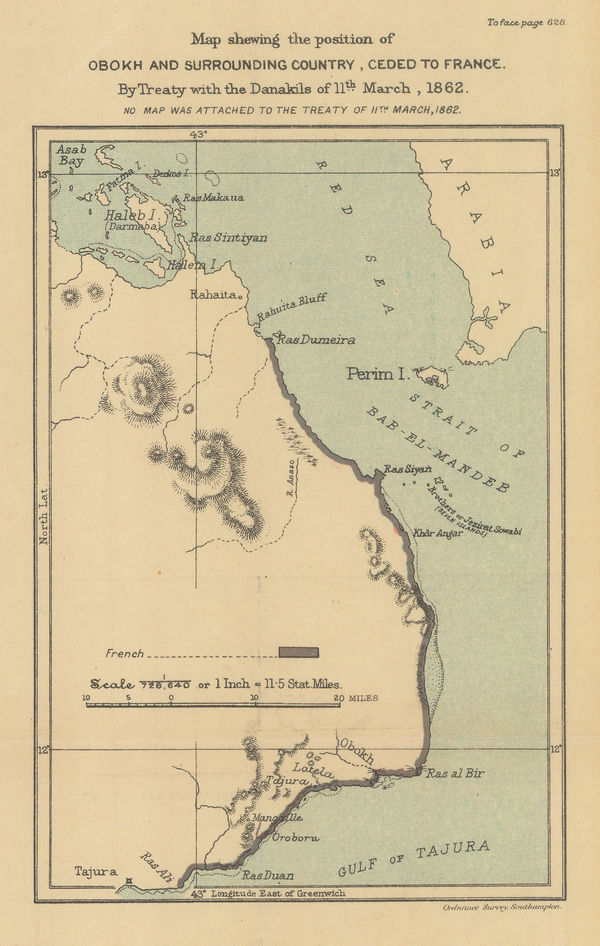
Map Showing the Position of Obokh and Surrounding Country, Ceded to France, 1909Edward HertsletSeries: SouthamptonEdward Hertslet, Map Showing the Position of Obokh and Surrounding Country, Ceded to France, 1909£ 32.00
-
Edward Hertslet, Sudan and Ethiopia, 1909£ 65.00
-
Edward Hertslet, Nyasa-Tanganyika Boundary, 1909£ 85.00
-
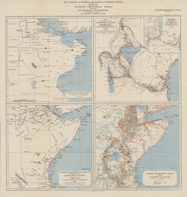
The Jubilee of Speke's Discovery of Victoria Nyanza, 1909Royal Geographical Society (RGS)Series: LondonRoyal Geographical Society (RGS), The Jubilee of Speke's Discovery of Victoria Nyanza, 1909£ 425.00
-
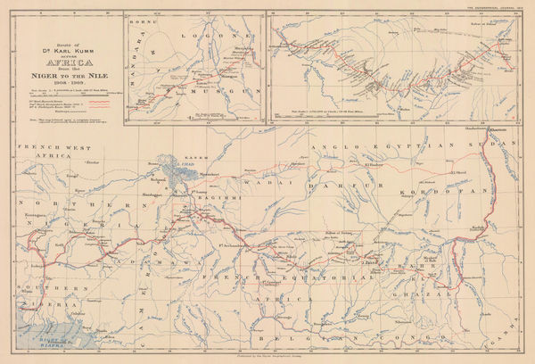
Dr. Karl Kumm's route from the Niger to the Nile, 1910Royal Geographical Society (RGS)Series: LondonRoyal Geographical Society (RGS), Dr. Karl Kumm's route from the Niger to the Nile, 1910£ 285.00
-
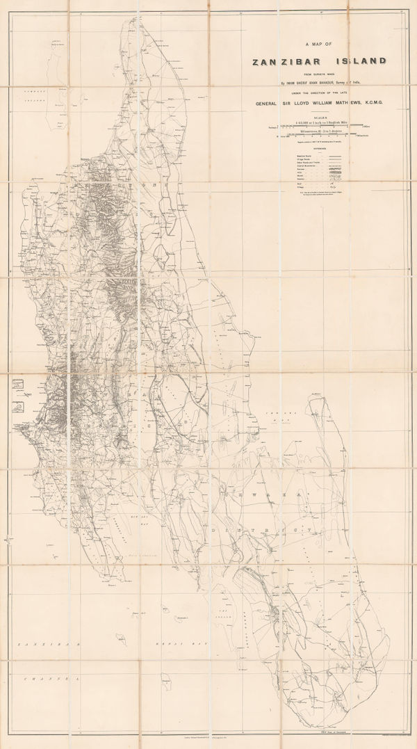
Edward Stanford, Zanzibar Island, 1910 (c.)£ 2,500.00
-
Royal Geographical Society (RGS), Southern Abyssinia, 1911£ 385.00
-
War Office, Marsabit, Northern Kenya, 1915£ 395.00
-
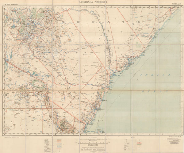
War Office, Kenya from Mombasa to Nairobi, 1915£ 695.00
-
War Office, Lake Victoria, 1917£ 595.00
-
Royal Geographical Society (RGS), East Africa, 1918£ 525.00


Page
2
of 3