-
 Martin Waldseemüller & Laurent Fries, The Second Printed Map of Southern Africa, 1541£ 4,950.00
 -
Alain Manesson Mallet, South Africa, 1683£ 295.00
-
Nicolas de Fer, Southern & Central Africa, 1702£ 795.00
-
Covens (Jean) & Mortier (Cornelius), Southern & Central Africa, 1730 c.£ 1,250.00
-
Emanuel Bowen, A New & Accurate Map of the Southern Parts of Africa, 1747£ 695.00
-
Tobias Conrad Lotter, Southern Africa & the Cape of Good Hope, 1778£ 745.00
-
Charles Francois Delamarche, Southern & Central Africa, 1795£ 325.00
-
Adrien Brue, Southern Africa & the Cape Colony, 1828 c.£ 250.00
-
Africa between 10 and 30 degree South Latitude. Map to illustrate the routes of Galton. Livingstone, Oswell and Gassiot, 1852Royal Geographical Society (RGS)Series: LondonRoyal Geographical Society (RGS), Africa between 10 and 30 degree South Latitude. Map to illustrate the routes of Galton. Livingstone, Oswell and Gassiot, 1852£ 495.00
-
Royal Geographical Society (RGS), Portuguese Exploration in Central Africa, 1859£ 385.00
-
Royal Geographical Society (RGS), The Discovery of Lake Malawi (Nyasa), 1863£ 175.00
-
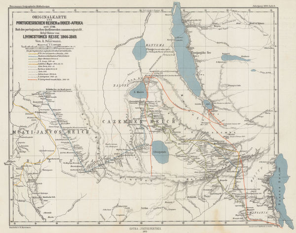
Justus Perthes, Exploration of Zambia, Malawi & Tanzania, 1870£ 78.00
-
F.A. Brockhaus, Stanley's discoveries in the Congo River Basin, 1878 c.£ 1,250.00
-
Map of the Route of the R.G.S. East African Expedition to Lakes Nyassa & Tanganyika, 1880Royal Geographical Society (RGS)Series: LondonRoyal Geographical Society (RGS), Map of the Route of the R.G.S. East African Expedition to Lakes Nyassa & Tanganyika, 1880£ 225.00
-
The Stevenson Road from Lake Malawi to Lake Tanganyika, 1890Scottish Geographical Society (SGS)Series: LondonScottish Geographical Society (SGS), The Stevenson Road from Lake Malawi to Lake Tanganyika, 1890£ 275.00
-
Scottish Geographical Society (SGS), Stanley's Emin Pasha Expedition, 1890£ 775.00
-
Scottish Geographical Society (SGS), Congo Free State, 1905£ 175.00
-
Scottish Geographical Society (SGS), Congo Free State, 1905£ 225.00
-
Walter Boldero Paton, Map of the Union of South Africa, 1912£ 295.00
-
Royal Geographical Society (RGS), East Africa, 1918£ 525.00
-
John Bartholomew & Son, Central and Southern Africa, 1922£ 145.00
Malawi
Our entire inventory of over 10,000 antique and vintage maps is now available to browse by region, date, cartographer, and subject