-
 Martin Waldseemüller & Laurent Fries, The Second Printed Map of Southern Africa, 1541£ 4,950.00
 -
Willem & Jan Blaeu, Southern & Central Africa, 1640 c.£ 1,250.00
-
Nicolas & Guillaume Sanson, Southern Africa, 1656£ 695.00
-
Athanasius Kircher, The Source of the Nile in the Mountains of the Moon, 1665£ 1,750.00
-
Robert Morden, Southern & Central Africa, 1688£ 375.00
-
Pierre Duval, Southern & Central Africa, 1694£ 295.00
-
Nicolas de Fer, Southern & Central Africa, 1702£ 795.00
-
Covens (Jean) & Mortier (Cornelius), Southern & Central Africa, 1730 c.£ 1,250.00
-
Nicolas Sanson, Southern Africa and Madagascar, 1741£ 875.00
-
Emanuel Bowen, A New & Accurate Map of the Southern Parts of Africa, 1747£ 695.00
-
Tobias Conrad Lotter, Southern Africa & the Cape of Good Hope, 1778£ 745.00
-
Rigobert Bonne, Southern Africa, 1790 c.£ 150.00
-
Charles Francois Delamarche, Southern & Central Africa, 1795£ 325.00
-
Adrien Brue, Southern Africa & the Cape Colony, 1828 c.£ 250.00
-
Africa between 10 and 30 degree South Latitude. Map to illustrate the routes of Galton. Livingstone, Oswell and Gassiot, 1852Royal Geographical Society (RGS)Series: LondonRoyal Geographical Society (RGS), Africa between 10 and 30 degree South Latitude. Map to illustrate the routes of Galton. Livingstone, Oswell and Gassiot, 1852£ 495.00
-
Royal Geographical Society (RGS), Southern Central Africa, 1856£ 225.00
-
Map to illustrate A Visit to Moselekatse, King of the Matebele, 1856Royal Geographical Society (RGS)Series: LondonRoyal Geographical Society (RGS), Map to illustrate A Visit to Moselekatse, King of the Matebele, 1856£ 145.00
-
Royal Geographical Society (RGS), Portuguese Exploration in Central Africa, 1859£ 385.00
-
Royal Geographical Society (RGS), The Discovery of Lake Malawi (Nyasa), 1863£ 175.00
-
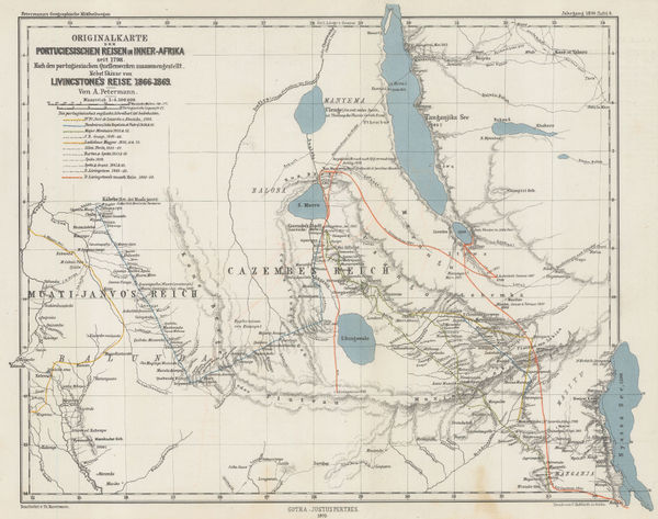
Justus Perthes, Exploration of Zambia, Malawi & Tanzania, 1870£ 78.00
-
Justus Perthes, Interior of South Africa, Botswana, and Zimbabwe, 1870£ 345.00
-
Sketch Map of Mr. Baines' Routes Between the Limpopo and Zambesi Rivers, 1871Royal Geographical Society (RGS)Series: LondonRoyal Geographical Society (RGS), Sketch Map of Mr. Baines' Routes Between the Limpopo and Zambesi Rivers, 1871£ 150.00
-
Map of Route from The Tati Settlement to Delagoa Bay, 1872Royal Geographical Society (RGS)Series: LondonRoyal Geographical Society (RGS), Map of Route from The Tati Settlement to Delagoa Bay, 1872£ 145.00
-
A Sketch map of Part of South Eastern Africa to Illustrate the Journeys of Dr Lacerda (1798) the Pombeiros (1806-11) and Major Monteiro (1831-32), 1873Royal Geographical Society (RGS)Series: LondonRoyal Geographical Society (RGS), A Sketch map of Part of South Eastern Africa to Illustrate the Journeys of Dr Lacerda (1798) the Pombeiros (1806-11) and Major Monteiro (1831-32), 1873£ 395.00
-
Reduction of Lieut. Cameron's Preliminary Map of his Route & The Adjacent Country between Lake Tanganyika & Lovale, 1876Royal Geographical Society (RGS)Series: LondonRoyal Geographical Society (RGS), Reduction of Lieut. Cameron's Preliminary Map of his Route & The Adjacent Country between Lake Tanganyika & Lovale, 1876£ 645.00
-
F.A. Brockhaus, Stanley's discoveries in the Congo River Basin, 1878 c.£ 1,250.00
-
Map of the Central Portion of South Africa Illustrating Dr. Holub's Journeys 1873-9, 1880Royal Geographical Society (RGS)Series: LondonRoyal Geographical Society (RGS), Map of the Central Portion of South Africa Illustrating Dr. Holub's Journeys 1873-9, 1880£ 165.00
-
Central Africa - Map of the Central Zambesi Region, 1881Royal Geographical Society (RGS)Series: LondonRoyal Geographical Society (RGS), Central Africa - Map of the Central Zambesi Region, 1881£ 175.00
-
Royal Geographical Society (RGS), The Interior of South Africa, 1884£ 795.00
-
J.G. Bartholomew, Central Africa, 1887£ 42.00
-
Map of Mr. F.C. Selous' Routes in the Matabele and Mashuna Countries, 1888Royal Geographical Society (RGS)Series: LondonRoyal Geographical Society (RGS), Map of Mr. F.C. Selous' Routes in the Matabele and Mashuna Countries, 1888£ 195.00
-
Justus Perthes, Geological Map of South Africa, 1888£ 95.00
-
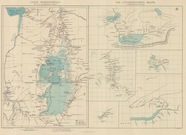
Royal Geographical Society (RGS), Livingstone's maps of Lake Bangweulu, Zimbabwe, 1889£ 145.00
-
The Stevenson Road from Lake Malawi to Lake Tanganyika, 1890Scottish Geographical Society (SGS)Series: LondonScottish Geographical Society (SGS), The Stevenson Road from Lake Malawi to Lake Tanganyika, 1890£ 275.00
-
Scottish Geographical Society (SGS), Stanley's Emin Pasha Expedition, 1890£ 775.00
-
Scottish Geographical Society (SGS), Political Sketch-Map of Central Africa, 1890£ 595.00
-
George W. Bacon, Bacon's Large-Print Map of South Africa, 1890 c.£ 775.00
-
Map of the Country between the Shire and Zambesi Rivers, 1892Scottish Geographical Society (SGS)Series: EdinburghScottish Geographical Society (SGS), Map of the Country between the Shire and Zambesi Rivers, 1892£ 80.00
-
Royal Geographical Society (RGS), Mozambique and Zimbabwe, 1892£ 145.00
-
Royal Geographical Society (RGS), Malawi and Zambia, 1893£ 145.00
-
Royal Geographical Society (RGS), Map of Mashonaland and Manika, 1895£ 445.00
-
Royal Geographical Society (RGS), Zambia & Victoria Falls, 1897£ 145.00
-
Scottish Geographical Society (SGS), Orographical map of Southern Rhodesia, 1897£ 375.00
-
Royal Geographical Society (RGS), Eastern Zambia, 1898£ 135.00
-
Edward Stanford, The Boer Republics, 1899£ 385.00
-
W & A.K. Johnstons Map to Illustrate the Transvaal Question, 1899W. & A.K. JohnstonSeries: Edinburgh & LondonW. & A.K. Johnston, W & A.K. Johnstons Map to Illustrate the Transvaal Question, 1899£ 445.00
-
Map Shewing The Gold Districts of Mashonaland & Matabeleland, 1900Scottish Geographical Society (SGS)Series: EdinburghScottish Geographical Society (SGS), Map Shewing The Gold Districts of Mashonaland & Matabeleland, 1900£ 395.00
-
F Bianconi, Southern Africa during the Boer War, 1900£ 495.00
-
Scottish Geographical Society (SGS), A Map of Rhodesia, 1900£ 375.00
-
The Times Map of British South Africa, the Transvaal and Orange Free State, 1900 c.The TimesSeries: LondonThe Times, The Times Map of British South Africa, the Transvaal and Orange Free State, 1900 c.£ 695.00
-
Royal Geographical Society (RGS), A Map of Marotseland, 1901£ 425.00
-
Scottish Geographical Society (SGS), Congo Free State, 1905£ 175.00
-
Scottish Geographical Society (SGS), Congo Free State, 1905£ 225.00
-
Royal Geographical Society (RGS), Eastern Zambia, 1907£ 175.00
-
Royal Geographical Society (RGS), Zambia & the Congo, 1910£ 175.00
-
Walter Boldero Paton, Map of the Union of South Africa, 1912£ 295.00
-
Royal Geographical Society (RGS), Map of Rhodesia, 1916£ 425.00
-
John Bartholomew & Son, Central and Southern Africa, 1922£ 145.00
Zambia & Zimbabwe
Our entire inventory of over 10,000 antique and vintage maps is now available to browse by region, date, cartographer, and subject