-
 R. P. Carceri, Korea, 1872£ 1,950.00
 -
Royal Geographical Society (RGS), Kyoto to Tokyo route map, 1873£ 165.00
-
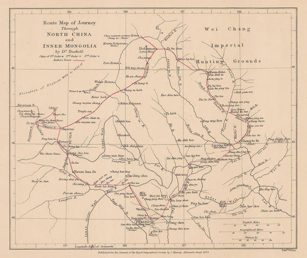
Route Map of Journey Through North China and Inner Mongolia, 1874Royal Geographical Society (RGS)Series: LondonRoyal Geographical Society (RGS), Route Map of Journey Through North China and Inner Mongolia, 1874£ 110.00
-
Society for the Diffusion of Useful Knowledge (SDUK), China, 1875£ 275.00
-
Society for the Diffusion of Useful Knowledge (SDUK), Empire of Japan, 1875£ 545.00
-
Map Showing Routes of Native Explorers in Tibet and Nepal, 1875Royal Geographical Society (RGS)Series: LondonRoyal Geographical Society (RGS), Map Showing Routes of Native Explorers in Tibet and Nepal, 1875£ 745.00
-
Map Showing the Proposed Trade Routes from India & British Burmah to China, 1875Royal Geographical Society (RGS)Series: LondonRoyal Geographical Society (RGS), Map Showing the Proposed Trade Routes from India & British Burmah to China, 1875£ 395.00
-
The Journey of the Pundit Nain Singh through Great Tibet, 1877Royal Geographical Society (RGS)Series: LondonRoyal Geographical Society (RGS), The Journey of the Pundit Nain Singh through Great Tibet, 1877£ 425.00
-
Route Map of Capt. W. J. Gill's Journey in Western China & Eastern Tibet, 1878Royal Geographical Society (RGS)Series: LondonRoyal Geographical Society (RGS), Route Map of Capt. W. J. Gill's Journey in Western China & Eastern Tibet, 1878£ 255.00
-
Justus Perthes, The Province of Canton, 1878£ 450.00
-
Justus Perthes, Tokyo and Mount Fuji, 1879£ 245.00
-
-
Royal Geographical Society (RGS), Eastern China, 1880£ 275.00
-
-
A. & C. Black, China, 1880 c.£ 225.00
-
John Dower, China and Japan, 1880 c.£ 195.00
-
Erwin Knipping's Route from Kanagawa to the Oyama and Hakone Mountains, 1881Justus PerthesSeries: GothaJustus Perthes, Erwin Knipping's Route from Kanagawa to the Oyama and Hakone Mountains, 1881£ 125.00
-
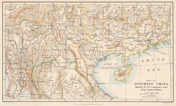
Royal Geographical Society (RGS), Map of Southern China, 1882£ 245.00
-
George Philip & Son Ltd., Japan, 1882£ 145.00
-
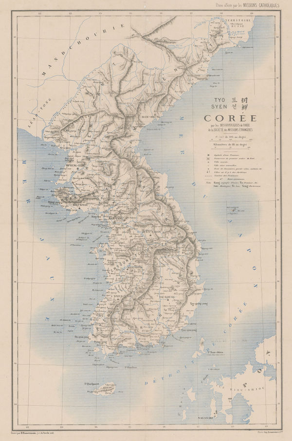
Justus Perthes, Korea, 1883£ 750.00
-
Royal Geographical Society (RGS), Southern Taiwan, 1885£ 225.00
-
George W. Bacon, Japan, 1885 (c.)£ 145.00
-
Royal Geographical Society (RGS), Sketch Map of South Western China, 1886£ 345.00
-
Royal Geographical Society (RGS), Map of Manchuria, 1887£ 275.00
-
Royal Geographical Society (RGS), Map of Tibet, 1887£ 395.00
-
-
Arbuckle Brothers Company, [Chinese Empire], 1889£ 145.00
-
Sagano Hikotaro, Japan, 1889£ 1,650.00
-
Anonymous, Sketch map of Victoria, Hong Kong, 1890 c.£ 425.00
-
Royal Geographical Society (RGS), Tianshan Mountains, 1891£ 150.00
-
Edward Stanford, Tokyo and environs, 1891£ 95.00
-
Royal Geographical Society (RGS), Northern Korea, 1892£ 145.00
-
Royal Geographical Society (RGS), Geological map of Hokkaido, 1893£ 185.00
-
F.A. Brockhaus, Macao, Canton (Guangzhou) and the Pearl River, 1893£ 62.00
-
Justus Perthes, Earthquake map of Japan, 1893£ 225.00
-
Royal Geographical Society (RGS), Tibet and the Surrounding Regions, 1894£ 795.00
-
Justus Perthes, Tokyo and Environs, 1894£ 95.00
-
Inoma Shozaburo, Korea, 1897£ 1,750.00
-
Sketch Map of Central China showing the basin of the Yang-tse-chiang, 1898Royal Geographical Society (RGS)Series: LondonRoyal Geographical Society (RGS), Sketch Map of Central China showing the basin of the Yang-tse-chiang, 1898£ 225.00
-
Royal Geographical Society (RGS), Central and Southern Manchuria, 1899£ 395.00
-
Edward Stanford, China, 1899£ 795.00
-
Royal Geographical Society (RGS), Part of Tibet and Sin-Chiang, 1900£ 545.00
-
Thomas Ferguson, Waterways near Shanghai, 1900£ 4,500.00
-
War Office, Early 20th century plan of Beijing (Peking), 1900 c.£ 4,500.00
-
Edward Stanford, Map of China prepared for The China Inland Mission, 1903£ 3,500.00
-
Royal Geographical Society (RGS), South Western China, 1903£ 195.00
-
H. T. Wade, Shanghai, Wuhu and Ningpo, 1903£ 4,500.00
-
British Admiralty, Hong Kong to Gulf of Liau-Tung, 1904£ 595.00
-
Edward Stanford, The Russo-Japanese War, 1904£ 1,450.00
-
The Seat of War: Bird's-Eye View of the Theatre of Operations, 1904The Graphic MagazineSeries: LondonThe Graphic Magazine, The Seat of War: Bird's-Eye View of the Theatre of Operations, 1904£ 325.00
-
Tibet, Map showing Explorations by Major C. H. D. Ryder RE DSO and Captains H. Wood RE & H. W. Cowie RE of the Tibet Frontier Commission 1904, 1905Royal Geographical Society (RGS)Series: LondonRoyal Geographical Society (RGS), Tibet, Map showing Explorations by Major C. H. D. Ryder RE DSO and Captains H. Wood RE & H. W. Cowie RE of the Tibet Frontier Commission 1904, 1905£ 375.00
-
Royal Geographical Society (RGS), Plan of Lhasa, 1905£ 295.00
-
Royal Geographical Society (RGS), The Southern Japanese Alps, 1906£ 245.00
-
Royal Geographical Society (RGS), Central Asia - Leh to Peking, 1907£ 445.00
-
Royal Geographical Society (RGS), China - Routes and Rivers in An-Hui, 1907£ 225.00
-
-
Richard Holmes Laurie, Inland Sea of Japan (Setouchi), 1908£ 72.00
-
-
Sketch Map of Ordos to illustrate a paper by W. R. Carles. C. M. G., 1909Royal Geographical Society (RGS)Series: LondonRoyal Geographical Society (RGS), Sketch Map of Ordos to illustrate a paper by W. R. Carles. C. M. G., 1909£ 185.00
-
Royal Geographical Society (RGS), Sketch Map of Tibet, 1909£ 325.00
-
Russian schematic map of the Ussuriysk, Manchurian, and Korean Railroads, 1910 c.G. De KelschSeries: St. PetersburgG. De Kelsch, Russian schematic map of the Ussuriysk, Manchurian, and Korean Railroads, 1910 c.£ 525.00
-
Edward Stanford, A Map of China prepared for the China Inland Mission, 1911£ 1,450.00
-
Y Koshiba, Mineral Distribution of Japanese Empire, 1911£ 1,850.00
-
Joseph Meyer, Macao, 1912£ 125.00
-
Part of the North-Eastern Frontier and Tibet showing the routes of Captains Morshead and Bailey 1913, 1914Royal Geographical Society (RGS)Series: LondonRoyal Geographical Society (RGS), Part of the North-Eastern Frontier and Tibet showing the routes of Captains Morshead and Bailey 1913, 1914£ 285.00
-
Brett's Pharmacy, Tourist guide of Yokohama, 1920 c.£ 145.00
-
Anonymous, Eastern District of Victoria City, 1920 c.£ 445.00
-
Anonymous, Western District of Victoria City, 1920 c.£ 445.00
-
Carl Crow, Plan of Hong Kong, City of Victoria, 1921£ 495.00
-
Kinosuke Inouye, Map of Applied Geology - Japan - Copper, 1922£ 495.00
-
Kue Shan Is. to the Yang Tse Kiang including the Chusan Archipelago, 1922British AdmiraltySeries: LondonBritish Admiralty, Kue Shan Is. to the Yang Tse Kiang including the Chusan Archipelago, 1922£ 1,450.00
-
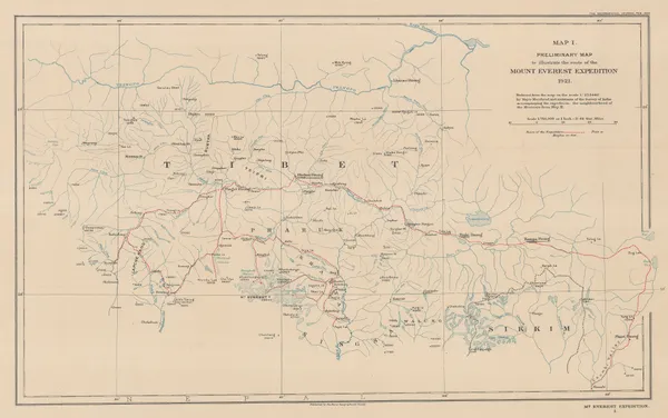
Preliminary Map to Illustrate the Route of the Mount Everest Expedition, 1922Royal Geographical Society (RGS)Series: LondonRoyal Geographical Society (RGS), Preliminary Map to Illustrate the Route of the Mount Everest Expedition, 1922£ 675.00
-
Royal Geographical Society (RGS), The Geology of the Mount Everest Region, 1922£ 675.00
-
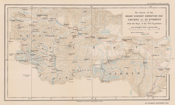
The Route of the Mount Everest Expedition 1922, Chumbi to Mt. Everest from the maps of the 1921 Expedition, 1922Royal Geographical Society (RGS)Series: LondonRoyal Geographical Society (RGS), The Route of the Mount Everest Expedition 1922, Chumbi to Mt. Everest from the maps of the 1921 Expedition, 1922£ 675.00
-
E. W. Gregory, Beijing, 1922£ 1,550.00
-
-
British Admiralty, Amoy to Nagasaki, 1923£ 1,350.00
-
British Admiralty, Rare chart of Taiwan (Formosa) and the Taiwan Strait, 1923£ 3,950.00
-
British Admiralty, Rare and detailed chart of northern Taiwan (Formosa), 1923£ 2,950.00
-
British Admiralty, Gogo Shima to Miyo Shima including Kurushima Kaikyo, 1923£ 495.00


![Arbuckle Brothers Company, [Chinese Empire], 1889](https://static-assets.artlogic.net/w_600,c_limit,f_auto,fl_lossy,q_auto/artlogicstorage/themaphouse/images/view/cfce919992a86f044f4cb6e0f401cf82j/themaphouse-arbuckle-brothers-company-chinese-empire-1889.jpg)


Page
3
of 5