-

-
Petrus Bertius, Iceland, 1606£ 595.00
-
-
Henricus Hondius, Iceland, 1635 c.£ 2,250.00
-
-
Vincenzo Coronelli, Iceland, 1692£ 950.00
-
Johannes van Keulen, North Atlantic, 1695£ 1,375.00
-
Valk & Schenk, Iceland, 1695 c£ 1,650.00
-
Pieter van der Aa, North Atlantic, Greenland & Iceland, 1714£ 485.00
-
Jon Eiríksson & Gerhard Schøning, Iceland, 1802£ 945.00
-
Johann Christoph Reinecke, Iceland, 1804£ 775.00
-
George Steuart MacKenzie, Southwest Coast of Iceland, 1811£ 1,250.00
-
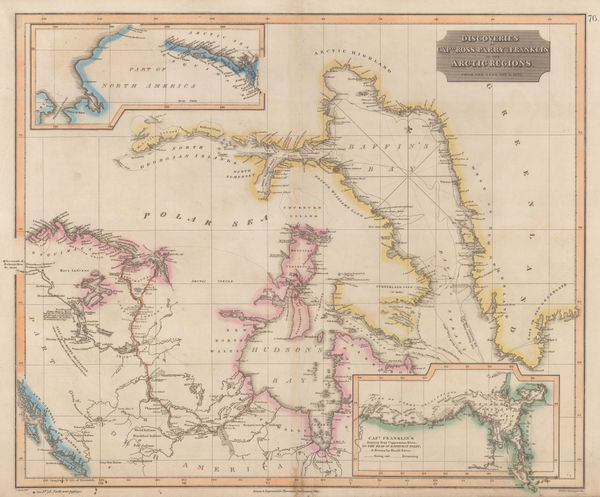
John Thomson, Discoveries of Ross, Parry & Franklin in the Arctic , 1830 c.£ 2,950.00
-
Justus Perthes, Die Meeres-Temperatur des Grönländischen Meeres, 1869£ 88.00
-
Surface Temperatures of the North Atlantic between Shetland & Greenland, 1870Royal Geographical Society (RGS)Series: LondonRoyal Geographical Society (RGS), Surface Temperatures of the North Atlantic between Shetland & Greenland, 1870£ 155.00
-
Justus Perthes, Ice Limits in the Greenland Sea, 1877£ 78.00
-
Justus Perthes, Greenland, 1880£ 175.00
-
W. & A.K. Johnston, Iceland, 1880 c.£ 125.00
-
George W. Bacon, Iceland, Greenland, and the Faroe Islands, 1880 c.£ 175.00
-
Royal Geographical Society (RGS), Map of Iceland, 1882£ 195.00
-
The Geographical Discoveries of Lieut. Greely's Expedition, 1882-3., 1885Scottish Geographical Society (SGS)Series: EdinburghScottish Geographical Society (SGS), The Geographical Discoveries of Lieut. Greely's Expedition, 1882-3., 1885£ 225.00
-
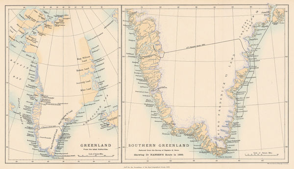
Royal Geographical Society (RGS), Nansen's First Crossing of Greenland, 1889£ 245.00
-
Arbuckle Brothers Company, Greenland, 1889£ 65.00
-
Sketch Map of Greenland and Surrounding Seas, 1890Scottish Geographical Society (SGS)Series: EdinburghScottish Geographical Society (SGS), Sketch Map of Greenland and Surrounding Seas, 1890£ 385.00
-
Justus Perthes, Die Arktische Windscheide und die Neuesten Polarprojekte, 1891£ 92.00
-
Sketch Map of Arctic Regions Showing Dr. Nansen's Projected Route, 1892Scottish Geographical Society (SGS)Series: EdinburghScottish Geographical Society (SGS), Sketch Map of Arctic Regions Showing Dr. Nansen's Projected Route, 1892£ 225.00
-
Royal Geographical Society (RGS), Map of Iceland, 1894£ 195.00
-
Justus Perthes, Geological Map of Southeast Iceland, 1895£ 78.00
-
Lilian Tennant, Iceland, 1912£ 395.00
-
Sketch Map to Illustrate Einar Mikkelsen's Expedition to North East Greenland 1909-12, 1913Royal Geographical Society (RGS)Series: LondonRoyal Geographical Society (RGS), Sketch Map to Illustrate Einar Mikkelsen's Expedition to North East Greenland 1909-12, 1913£ 88.00
-
Map of the North Polar Regions for "A Naturalist at the Poles", 1923John BartholomewSeries: EdinburghJohn Bartholomew, Map of the North Polar Regions for "A Naturalist at the Poles", 1923£ 195.00
Iceland & Greenland
Our entire inventory of over 10,000 antique and vintage maps is now available to browse by region, date, cartographer, and subject