-
 John Bartholomew & Co., Inter-war map of Turkey, Iraq, and the Levant, 1922£ 395.00
 -
Istanbul (Constantinople), 1922Société Anonyme Ottomane d'Etudes et d'Enterprises UrbainesSeries: IstanbulSociété Anonyme Ottomane d'Etudes et d'Enterprises Urbaines, Istanbul (Constantinople), 1922£ 950.00
-
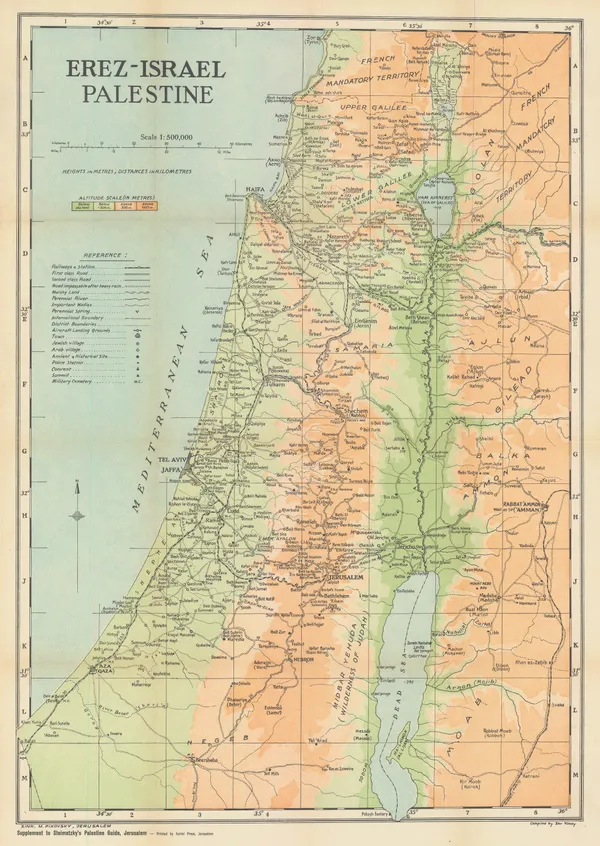
John Bartholomew & Co., Palestine, 1922£ 195.00
-
John Bartholomew & Son, Greece & the Aegean Sea, 1922£ 95.00
-
J.G. Bartholomew, Middle East, 1922£ 425.00
-
War Office, Riyadh, 1922£ 4,500.00
-
Royal Geographical Society (RGS), Northern Arabia, 1922£ 1,750.00
-
Motor and camel Surveys in the North Arabian Desert, 1923Royal Geographical Society (RGS)Series: LondonRoyal Geographical Society (RGS), Motor and camel Surveys in the North Arabian Desert, 1923£ 165.00
-
Royal Geographical Society (RGS), Air Mosaic of Petra, 1924£ 275.00
-
Arabia - Routes between 'Oqair and Jabrin Oasis in Eastern Nejd, 1925Royal Geographical Society (RGS)Series: LondonRoyal Geographical Society (RGS), Arabia - Routes between 'Oqair and Jabrin Oasis in Eastern Nejd, 1925£ 825.00
-
Thomas Cook, Jerusalem, 1925£ 78.00
-
Royal Geographical Society (RGS), Sketch maps of Oman and the UAE, 1925£ 775.00
-
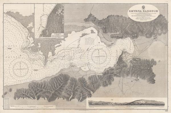
British Admiralty, Smyrna Harbour, 1926£ 985.00
-
Royal Geographical Society (RGS), Petra, 1930£ 275.00
-
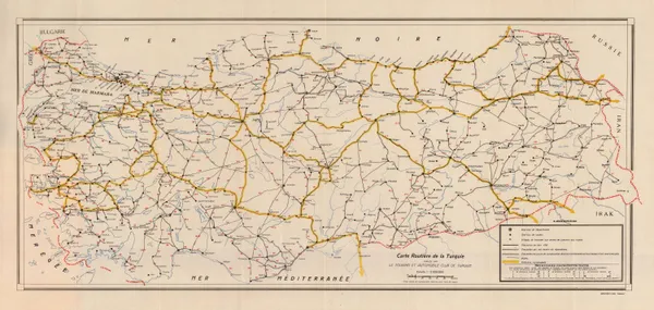
Basimevi Emel, Road map of Turkey, 1930 c.£ 125.00
-
Harmsworth, Gallipoli and Suvla Bay, 1930 c.£ 65.00
-
Royal Geographical Society (RGS), Arabia - Sketch map of Hadhramaut, 1931£ 145.00
-
Royal Geographical Society (RGS), Central South Arabia, 1931£ 375.00
-
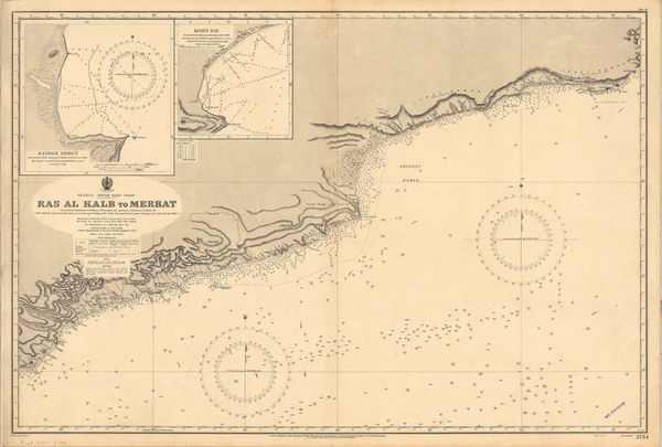
British Admiralty, Merbat to Masira Island., 1931£ 1,550.00
-
British Admiralty, Chart of the South Arabian coast, 1931£ 1,550.00
-
Royal Geographical Society (RGS), Rub' al Khali from Dhufar to Doha, 1931£ 1,350.00
-
Justus Perthes, Western Iran, Iraq & the Caucasus, 1931£ 145.00
-
John Bartholomew & Son, Baghdad, 1934£ 115.00
-
John Bartholomew & Son, Damascus, 1934£ 68.00
-
John Bartholomew & Son, Jerusalem, 1934£ 88.00
-
Zev Vilnay, Haifa and Mt. Carmel, 1935£ 95.00
-
Zev Vilnay, Israel, 1935£ 295.00
-
George Philip & Son Ltd., The Middle East, 1935 (c.)£ 195.00
-
Aden Protectorate: Route traverse through the Hadhramaut from Mukalla to Seihut, 1934, 1936Royal Geographical Society (RGS)Series: LondonRoyal Geographical Society (RGS), Aden Protectorate: Route traverse through the Hadhramaut from Mukalla to Seihut, 1934, 1936£ 245.00
-
A Sketch Map Itinerarium of Part of North Western Arabia and Negd, 1936Charles Montagu DoughtySeries: LondonCharles Montagu Doughty, A Sketch Map Itinerarium of Part of North Western Arabia and Negd, 1936£ 950.00
-
British Admiralty, Arabian Sea, 1937£ 1,565.00
-
Christina Phelps Grant, The Syrian Desert Caravan Routes, 1937£ 250.00
-
Royal Geographical Society (RGS), Routes in South-West Arabia, 1938£ 275.00
-
Steimatzky's Publishing, Beirut, 1941£ 225.00
-
Steimatzky's Publishing, Damascus, 1941£ 85.00
-
Plans on the Northeast Coast of Bahrein Island, 1942United States Hydrographic OfficeSeries: Washington, D.C.United States Hydrographic Office, Plans on the Northeast Coast of Bahrein Island, 1942£ 3,950.00
-
-
War Office, Mecca & Jeddah, 1943£ 950.00
-
Survey of Palestine, Tel Aviv, 1944£ 745.00
-
War Office, Riyadh, 1944£ 2,250.00
-
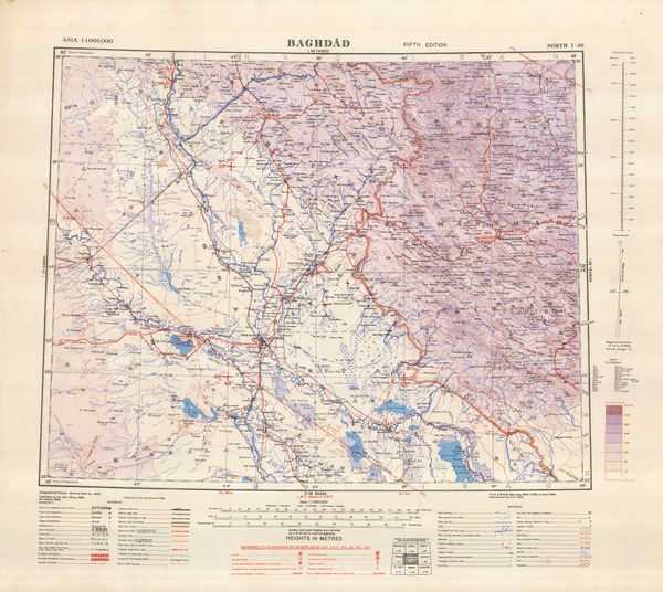
Geographical Section, General Staff (GSGS), Baghdad, 1945£ 395.00
-
Geographical Section, General Staff (GSGS), Muscat-Masira, 1945£ 845.00
-
Royal Geographical Society (RGS), Southern Arabia, 1946£ 785.00
-
-
Royal Geographical Society (RGS), Southern Arabia, 1949£ 385.00
-
Royal Geographical Society (RGS), Arabia: The Jabal Tuwaiq Region, 1949£ 275.00
-
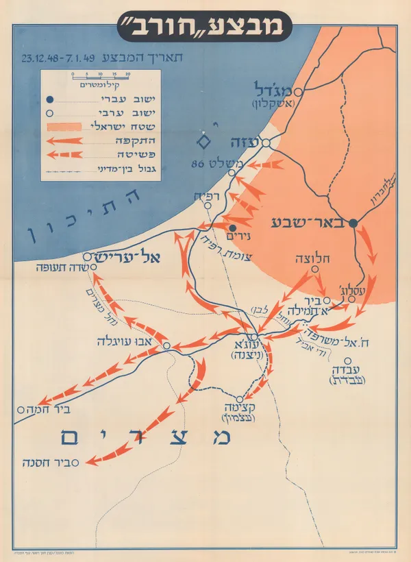
Israel Defense Forces (IDF), Operation Horev, 1950£ 450.00
-
Iraq State Railways, Railway Map of Iraq, 1950 c£ 295.00
-
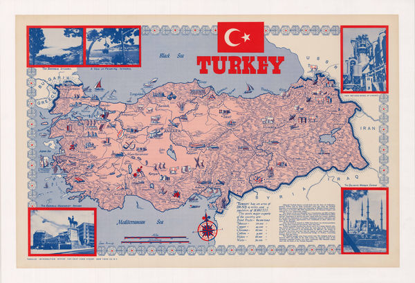
Turkish Info Office, Turkey, 1950 c.£ 950.00
-
British Admiralty, Entrance of the Persian Gulf, 1951£ 4,500.00
-
Royal Geographical Society (RGS), Wilfred Thesiger's Travels in Oman & UAE, 1951£ 2,950.00
-
Directorate-General of Propaganda, Map of Iraq, 1953£ 195.00
-
James Belgrave, Guide Map of the Bahrain Islands, 1954£ 1,250.00
-
James Belgrave, Manama, Bahrain, 1954£ 975.00
-
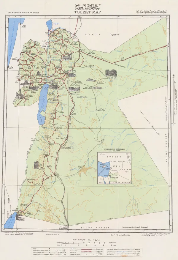
The Hashemite Kingdom of Jordan Tourist Map | المملكة الاردنية الهاشمية, 1955Tourism Authority H.K. of JordanSeries: AmmanTourism Authority H.K. of Jordan, The Hashemite Kingdom of Jordan Tourist Map | المملكة الاردنية الهاشمية, 1955£ 550.00
-
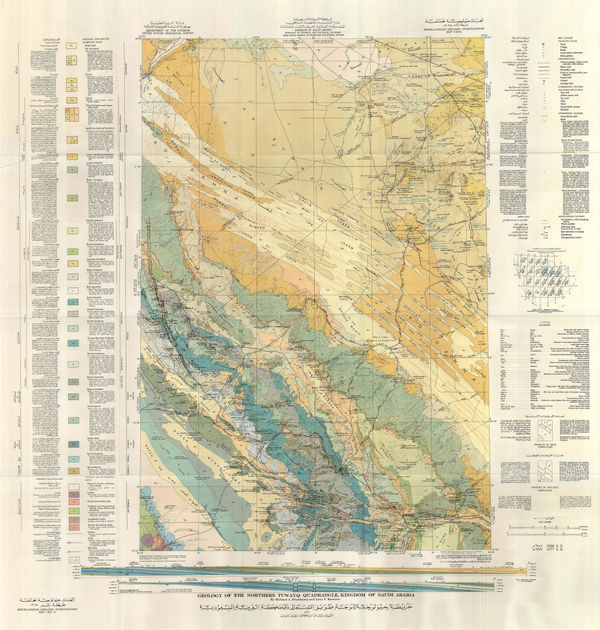
Geologic map of the Southern Tuwayq Quadrangle, Kingdom of Saudi Arabia, 1956Kingdom of Saudi Arabia / USGSSeries: Washington, D.C.Kingdom of Saudi Arabia / USGS, Geologic map of the Southern Tuwayq Quadrangle, Kingdom of Saudi Arabia, 1956£ 1,950.00
-
Survey of Palestine, Jerusalem, 1956£ 365.00
-
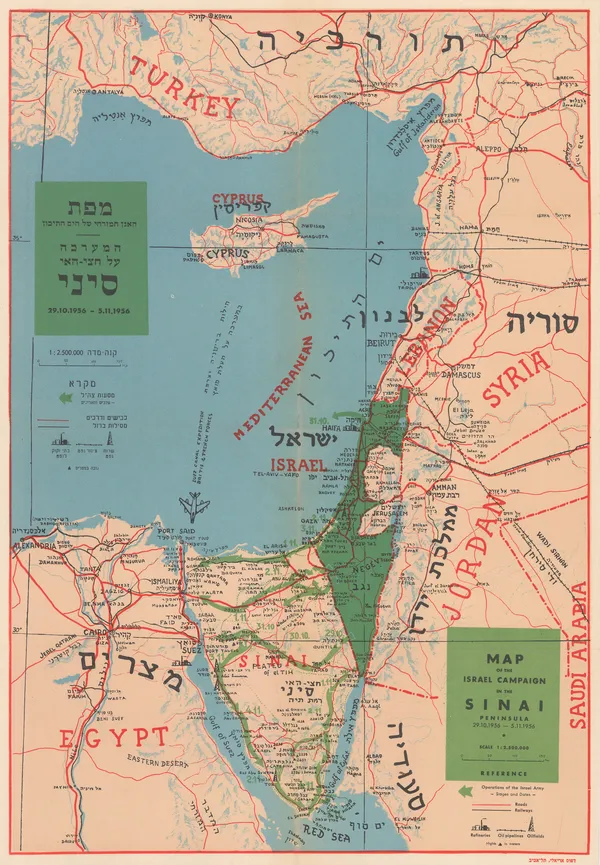
Dr. J Shapiro, Map of the Israel Campaign in the Sinai Peninsula, 1956£ 585.00
-
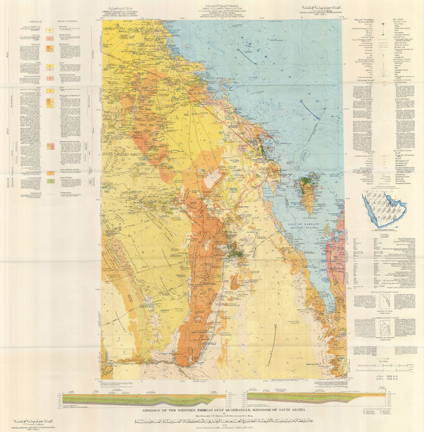
Geographical Section, General Staff (GSGS), Persian Gulf, 1956£ 750.00
-
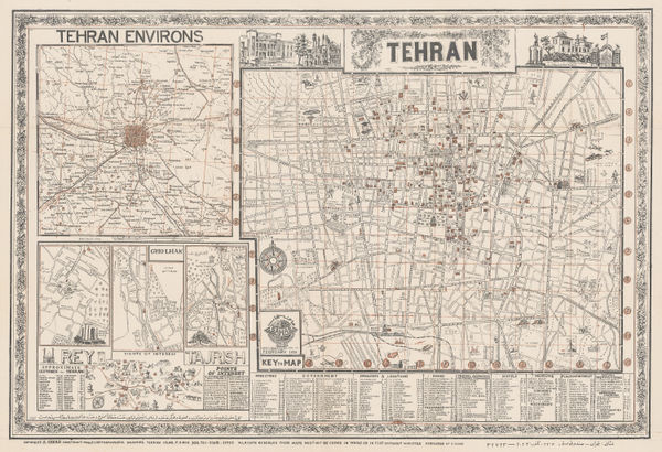
Abbas Sahab, Tehran and its Environs, 1956£ 950.00
-
-
-
-
Survey of Israel, Hebrew Map of the Middle East , 1958£ 1,250.00
-
Geologic map of the Asir Quadrangle, Kingdom of Saudi Arabia, 1959Kingdom of Saudi Arabia / USGSSeries: Washington, D.C.Kingdom of Saudi Arabia / USGS, Geologic map of the Asir Quadrangle, Kingdom of Saudi Arabia, 1959£ 1,950.00
-
Geologic map of the Northwestern Rub' al Khali Quadrangle, Kingdom of Saudi Arabia, 1959Kingdom of Saudi Arabia / USGSSeries: Washington, D.C.Kingdom of Saudi Arabia / USGS, Geologic map of the Northwestern Rub' al Khali Quadrangle, Kingdom of Saudi Arabia, 1959£ 1,950.00
-
Ibrahim Hilmi al-Ghouri, Palestine, Transjordan, Lebanon, Syria and Egypt, 1959 c£ 950.00
-
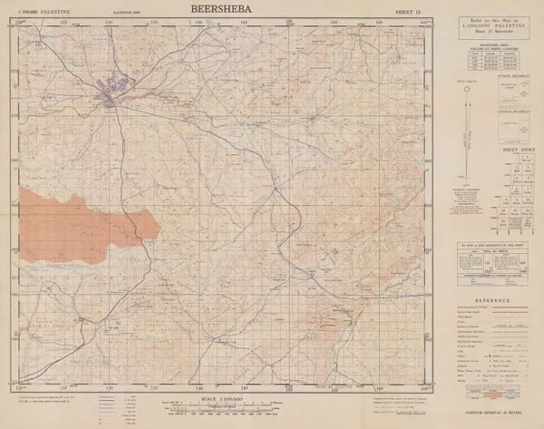
Survey of Palestine, Beersheba, 1960£ 295.00
-
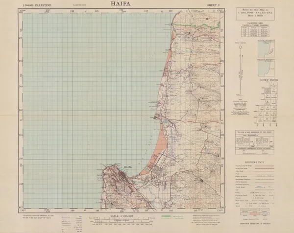
Survey of Palestine, Haifa, 1960£ 295.00
-
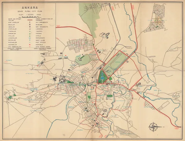
General Directorate of Highways, Ankara, 1960 c£ 395.00
-
Munim Eser, Tourist Plan of Istanbul, 1960 c.£ 425.00
-
Abbas Sahab, Isfahan: Half the World, 1961£ 675.00
-
Iraq Tourism Administration, Iraqi State Railways, 1961£ 195.00
-
Iraq Tourism Administration, Road Map of Iraq, 1961£ 195.00
-
Iraq Tourism Administration, Illustrated Map of Iraq, 1961£ 295.00
-
Iraq Tourism Administration, Baghdad City, 1961£ 345.00
-
Abbas Sahab, Tehran, 1961£ 1,250.00
-
Directorate General of Antiquities, Archaeological Map of Iraq, 1961£ 195.00
-
Iraq Tourism Administration, Iraq Summer Resorts, 1961£ 195.00
-
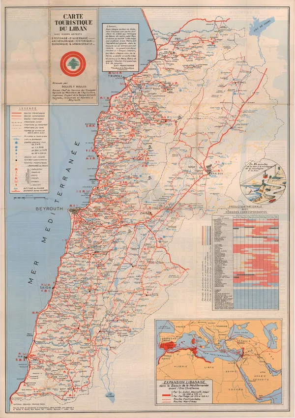
Boulos F. Boulos, Vintage map of Lebanon, 1964£ 2,500.00


Page
5
of 6