-
 Justus Perthes, German map of Central Persia (Iran), 1874£ 68.00
 -
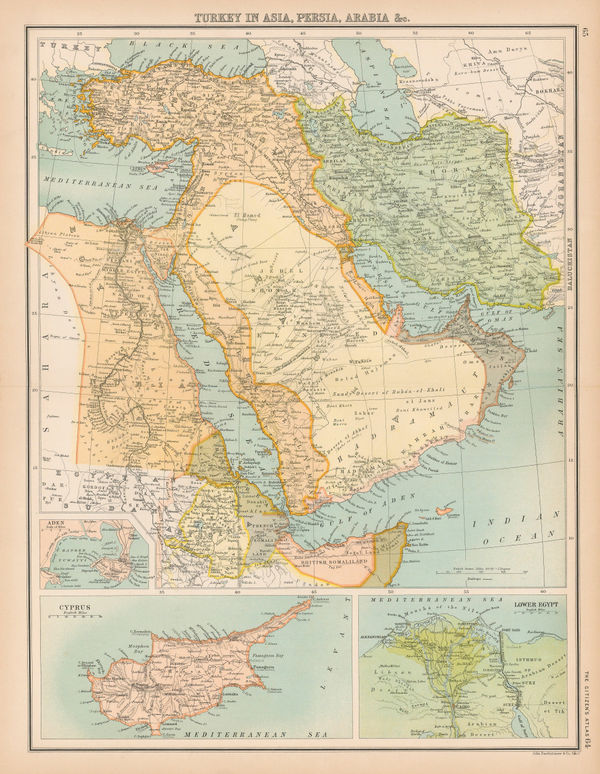
The Turkish Empire in Europe and Asia, 1875Society for the Diffusion of Useful Knowledge (SDUK)Series: LondonSociety for the Diffusion of Useful Knowledge (SDUK), The Turkish Empire in Europe and Asia, 1875£ 295.00
-
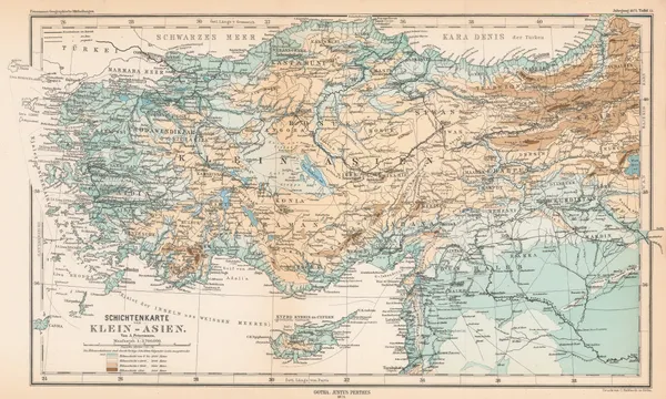
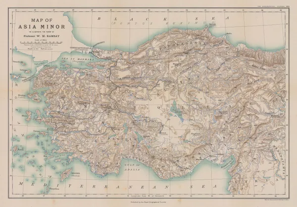
Justus Perthes, Asia Minor, 1875£ 145.00
-
A Map of The Northern Frontier of Khorassan with parts of Irak & Mazandaran, 1876Royal Geographical Society (RGS)Series: LondonRoyal Geographical Society (RGS), A Map of The Northern Frontier of Khorassan with parts of Irak & Mazandaran, 1876£ 445.00
-
Royal Geographical Society (RGS), Route Map from Jask to Bampūr, 1877£ 125.00
-
William Gifford Palgrave, Plan of Riyadh, 1877£ 2,250.00
-
Edward Stanford, Middle East, Central Asia and India, 1878£ 1,950.00
-
Edward Stanford, Istanbul & the Bosporus, 1878£ 78.00
-
Letts & Son, Turkey & the Balkans, 1878£ 850.00
-
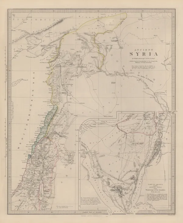
Society for the Diffusion of Useful Knowledge (SDUK), Ancient Syria, 1879£ 325.00
-
Royal Geographical Society (RGS), Northwest Arabia, 1879£ 485.00
-
Royal Geographical Society (RGS), Sketch of the Jebel Shammar, 1880£ 175.00
-
Royal Geographical Society (RGS), Map of Northern & Central Arabia, 1880£ 225.00
-
W. & A.K. Johnston, The Middle East, 1880 c£ 75.00
-
W. & A.K. Johnston, Persia, 1880 c£ 75.00
-
W. & A.K. Johnston, Ancient Persia, 1880 c£ 75.00
-
W. & A.K. Johnston, The Levant, 1880 c£ 75.00
-
W. & A.K. Johnston, Arabia, 1880 c.£ 125.00
-
Justus Perthes, Northwest Arabia, 1881£ 125.00
-
Richard Holmes Laurie, Chart of the Port of Aden, 1882£ 48.00
-
Friedrich Boemches, Beirut - Plan for a new Harbour, 1882£ 125.00
-
Letts & Son, Arabia, Egypt, Nubia & Abyssina, 1882£ 395.00
-
A Map of a Route Along the Alburz Mountains Between Tehran, Astrabad and Shahrud, 1883Royal Geographical Society (RGS)Series: LondonRoyal Geographical Society (RGS), A Map of a Route Along the Alburz Mountains Between Tehran, Astrabad and Shahrud, 1883£ 495.00
-
Arabia and the Surrounding Countries to illustrate the life of Mahomet and the Annals of the early Caliphate, 1883Edward StanfordSeries: LondonEdward Stanford, Arabia and the Surrounding Countries to illustrate the life of Mahomet and the Annals of the early Caliphate, 1883£ 3,850.00
-
W. & A.K. Johnston, The Islamic Empire, 1883£ 115.00
-
James Wyld, Map of the Countries Between England & India, 1885£ 1,250.00
-
Henry Cuthbert Tunison, The Middle East, 1885 (c.)£ 175.00
-
George W. Bacon, Turkey in Asia - eastern part, 1885 (c.)£ 325.00
-
Royal Geographical Society (RGS), Map of the Afgan and Persian Border, 1886£ 165.00
-
Justus Perthes, North-western Yemen, 1886£ 285.00
-
Royal Geographical Society (RGS), Central Iran (Persia), 1888£ 85.00
-
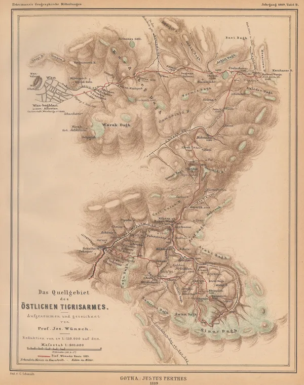
Justus Perthes, Source of the eastern arm of the Tigris River., 1889£ 85.00
-
Arbuckle Brothers Company, Iran (Persia), 1889£ 135.00
-
Arbuckle Brothers Company, Arabia, 1889£ 275.00
-
Arbuckle Brothers Company, Türkiye (Turkey), 1889£ 95.00
-
George Philip & Son Ltd., Iran, Afghanistan and part of Pakistan, 1890 c£ 68.00
-
George W. Bacon, Arabia, 1890 c£ 395.00
-
W. & A.K. Johnston, Jerusalem, 1890 c.£ 75.00
-
-
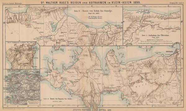
Justus Perthes, Asia Minor, 1892£ 165.00
-
-
Edward Stanford, Relief map of Istanbul (Constantinople) and the Bosphorus, 1894£ 195.00
-
Royal Geographical Society (RGS), Sketch Map of the Upper Euphrates in Turkey, 1896£ 245.00
-
Royal Geographical Society (RGS), Sketch Map of the Wadi Tyin in Oman, 1896£ 245.00
-
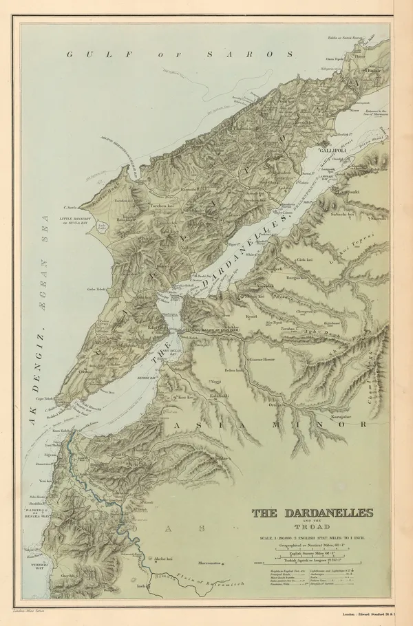
Edward Stanford, The Dardanelles and the Troad, 1896£ 145.00
-
Istanbul (Constantinople) and the Bosphorus, 1897Wilhelm Leopold Colmar Freiherr von der GoltzSeries: BerlinWilhelm Leopold Colmar Freiherr von der Goltz, Istanbul (Constantinople) and the Bosphorus, 1897£ 885.00
-
Royal Geographical Society (RGS), Early map of the Iraqi Oil Fields, 1897£ 845.00
-
Anonymous, Automobile Map of Arabia, 1897 (c.)£ 1,250.00
-
Royal Geographical Society (RGS), The Fadhli Country, 1898£ 395.00
-
Edward Stanford, The Country Around Jerusalem, 1901£ 65.00
-
Edward Stanford, Damascus, 1901£ 55.00
-
Royal Geographical Society (RGS), Map of Central Kurdistan by Major F.R. Maunsell, 1901£ 155.00
-
Edward Stanford, Jerusalem, 1901£ 145.00
-
Royal Geographical Society (RGS), Map of Asia Minor, 1902£ 225.00
-
Royal Geographical Society (RGS), Iran, Arghanistan and Pakistan, 1902£ 325.00
-
Edward Stanford, Palestine, 1904£ 200.00
-
Edward Stanford, Istanbul (Constantinople), 1904£ 85.00
-
Edward Stanford, Beirut, 1904£ 68.00
-
John Bartholomew & Co., Turkey in Asia, Arabia, Persia &c., 1905 (c.)£ 245.00
-
Royal Geographical Society (RGS), Iraq, Syria, Armenia and eastern Turkey, 1906£ 325.00
-
Sketch map of the overland route from Baghdad to Damascus, 1909Royal Geographical Society (RGS)Series: LondonRoyal Geographical Society (RGS), Sketch map of the overland route from Baghdad to Damascus, 1909£ 295.00
-
John Bartholomew & Co., The Indian Empire and Surrounding Countries, 1909£ 95.00
-
Royal Geographical Society (RGS), Kurdistan Region, Iraq, 1910£ 225.00
-
Royal Geographical Society (RGS), Sketch Map of North West Arabia, 1910£ 425.00
-
Royal Geographical Society (RGS), The Tigris Euphrates Delta, 1910£ 195.00
-
Balkan States & Asia Minor: Industries & Communications, 1910 c.George Philip & Son Ltd.Series: LondonGeorge Philip & Son Ltd., Balkan States & Asia Minor: Industries & Communications, 1910 c.£ 125.00
-
Enciclopedia Segui, Istanbul, 1910 c.£ 145.00
-
Royal Geographical Society (RGS), Map of North East Arabia, 1911£ 475.00
-
Royal Geographical Society (RGS), Sketch map of Northern Iran, 1911£ 125.00
-
Emery Walker, Arabia, 1911£ 145.00
-
W. & A.K. Johnston, Cook's Plan of Jerusalem, 1911£ 95.00
-
Royal Geographical Society (RGS), Lower Mesopotamia, 1912£ 225.00
-
-
Royal Geographical Society (RGS), The Troad / Biga Peninsula, 1912£ 135.00
-
Royal Geographical Society (RGS), Lower Mesopotamia, 1912£ 1,250.00
-
-
War Office, Southern Iraq from Baghdad to the Persian Gulf, 1915£ 1,250.00
-
Geographical Section, General Staff (GSGS), Iraq, Iran & Kuwait, 1918£ 2,850.00
-
-
Geographical Section, General Staff (GSGS), Persia (Iran) and Afghanistan, 1921£ 375.00


![Maḥmūd & Qulī Khān, نقشۀ شهر دار الخلافۀ ناصرى طهران صانها الله تعالى عن الحدثان [Map of the city of the Nasserite caliphate of Tehran], 1891 c.](https://static-assets.artlogic.net/w_600,c_limit,f_auto,fl_lossy,q_auto/artlogicstorage/themaphouse/images/view/ba254bcc61572c82a8055bad8e8e68f0j/themaphouse-ma-m-d-qul-kh-n-map-of-the-city-of-the-nasserite-caliphate-of-tehran-1891-c..jpg)


Page
4
of 6