-
 Pieter van der Aa, Arabia and South Asia, 1707£ 425.00
 -
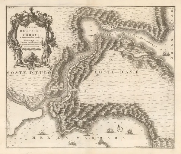
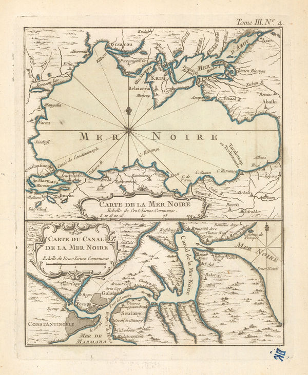
Nicolas & Guillaume Sanson, Rare map of the Bosphorous, 1711£ 1,950.00
-
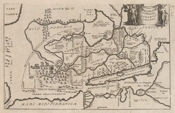
John Senex, Map of the Garden of Eden or the Levant, Arabia, Egypt and the Nile, 1711£ 395.00
-
Pieter van der Aa, La Rade de Gammeron, 1714£ 295.00
-
Henri Chatelain, Istanbul (Constantinople), 1719£ 545.00
-
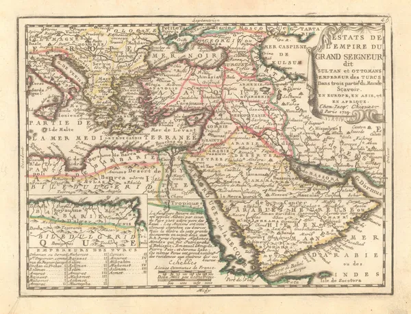
Henri Chatelain, The Turkish Empire, 1719£ 745.00
-
Jacques Chiquet, Middle East, 1719£ 345.00
-
The Bosphorus and panorama of Istanbul (Constantinople), 1720 c.Johann Baptist HomannSeries: NurembergJohann Baptist Homann, The Bosphorus and panorama of Istanbul (Constantinople), 1720 c.£ 3,250.00
-
Johann Baptist Homann, Persian Empire, 1722 c£ 1,250.00
-
Herman Moll, Ottoman Empire just after the Austro-Turkish War, 1725£ 695.00
-
Henri Michelot and Laurent Brémond, Eastern Mediterranean Sea Chart, 1726£ 2,650.00
-
Herman Moll, The Turkish Empire in Europe, Asia and Africa, 1730 c£ 4,450.00
-
Asiatic possessions of the Ottoman Empire, 1730 c.Covens (Jean) & Mortier (Cornelius)Series: AmsterdamCovens (Jean) & Mortier (Cornelius), Asiatic possessions of the Ottoman Empire, 1730 c.£ 385.00
-
-
Matthaus Seutter, Jerusalem, 1740£ 2,450.00
-
Jacques-Nicolas Bellin, Arabia, 1740£ 595.00
-
Matthaus Seutter, Istanbul (Constantinople), 1740 c.£ 3,650.00
-
Herman Moll, Asia Minor / Turkey, 1745£ 345.00
-
Georges-Louis Le Rouge, Turkish Empire at its height, 1748£ 275.00
-
Jacques-Nicolas Bellin, Chart of the Gulf of İskenderun, 1750£ 65.00
-
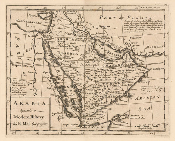
Herman Moll, Arabia Agreable to Modern History, 1750 c.£ 545.00
-
Jonas Hanway, Route map through Arabia, Persia (Iran), and India, 1753£ 895.00
-
Covens (Jean) & Mortier (Cornelius), Persia, 1757£ 1,150.00
-
Richard William Seale, Arabia, 1760 (c.)£ 2,250.00
-
Jacques-Nicolas Bellin, Chart of the Black Sea, Istanbul and the Bosphorus, 1764£ 245.00
-
Jacques-Nicolas Bellin, Town plan of Gallipoli, 1764£ 42.00
-
Jacques-Nicolas Bellin, West Coast of Arabia and the Red Sea, 1764£ 675.00
-
Nicholas Bellin, Istanbul, 1764£ 495.00
-
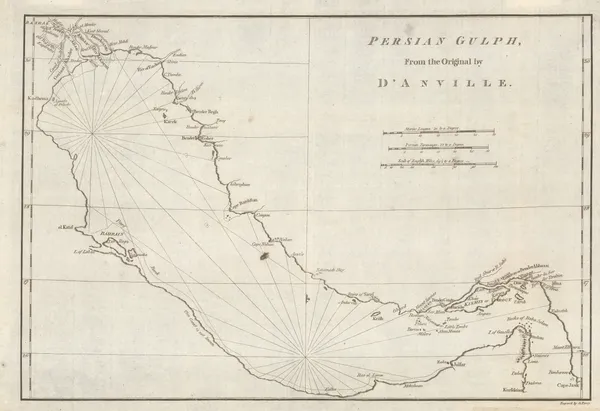
Jacques-Nicolas Bellin, The Persian Gulf, 1764£ 875.00
-
Jacques-Nicolas Bellin, Dardanelles, 1764£ 195.00
-
Jacques-Nicolas Bellin, Acre & Haifa, Israel, 1764£ 115.00
-
Jacques-Nicolas Bellin, Tripoli, Lebanon, 1764£ 125.00
-
Jacques-Nicolas Bellin, Basra & the Mouth of the Euphrates, 1764£ 395.00
-
Jacques-Nicolas Bellin, Türkiye (Asia Minor), 1764£ 225.00
-
Jacques-Nicolas Bellin, Sea of Marmara, 1764£ 395.00
-
Jacques-Nicolas Bellin, Sidon, Lebanon, 1764£ 145.00
-
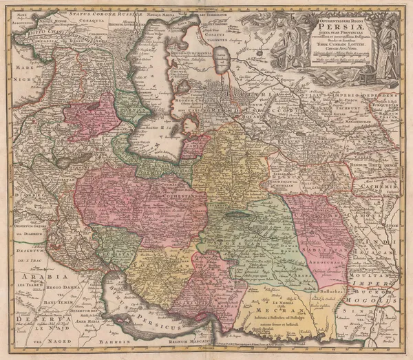
Tobias Conrad Lotter, Persia (Iran), 1765 c.£ 850.00
-
Universal Magazine, Istanbul (Constantinople), 1770£ 725.00
-
Rigobert Bonne, Carte De L'Arabie, 1771£ 695.00
-
Rigobert Bonne, The Eastern Ottoman Empire, 1771 c.£ 345.00
-
Jacques-Nicolas Bellin, Chart of the Sea of Marmara, 1772£ 985.00
-
Carsten Niebuhr, The Red Sea, 1772£ 2,250.00
-
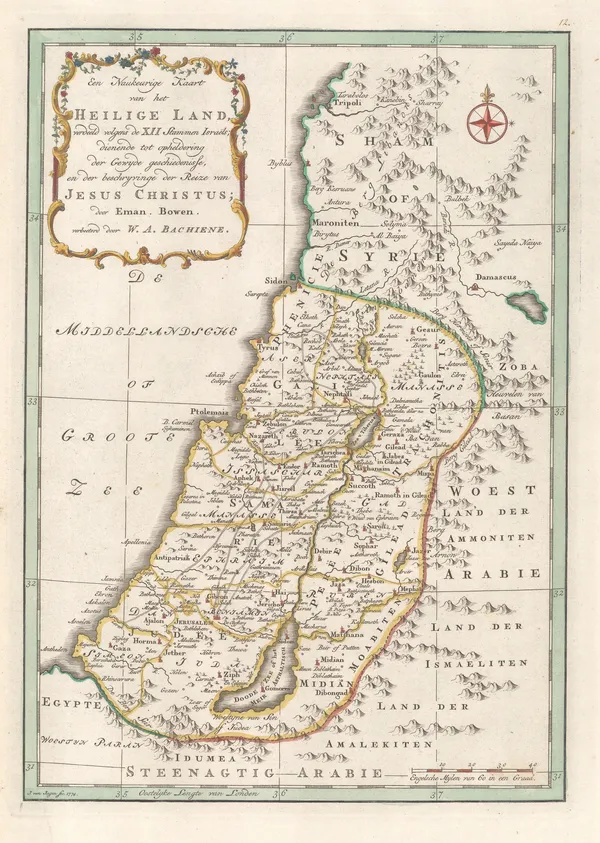
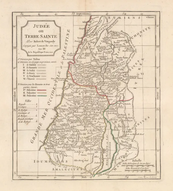
Willem Albert Bachiene, Holy Land, 1774£ 445.00
-
Carsten Niebuhr, Oman, 1774£ 1,250.00
-
Tobias & Gustav Lotter, Yemen, 1774 c.£ 1,250.00
-
London Magazine, View of Ancient Troas together with the Scamander and Mount Ida, 1775£ 175.00
-
Guillaume-Nicolas Delahaye, Chart of the Persian Gulf, 1775 c.£ 2,250.00
-
Robert de Vaugondy, West Asia & The Middle East, 1778£ 445.00
-
Francois Santini, Anatolia, Turkey divided into its provinces, 1779£ 325.00
-
J.B.B. D'Anville, Course of the Euphrates and Tigris Rivers, 1779£ 595.00
-
Carsten Niebuhr, Port of Qishn, Yemen, 1779£ 195.00
-
Carsten Niebuhr, Yemen, 1779£ 985.00
-
Francois Santini, The Persian Empire (Iran), 1779£ 595.00
-
Rigobert Bonne, Arabia, 1780 c.£ 395.00
-
Jean-Baptiste-Claude Delisle de Sales, Arabia, 1782£ 475.00
-
John Harrison, Chart of the Persian Gulf, 1788£ 775.00
-
Laurie & Whittle, A Chart of the Northern Part of the Indian Ocean, 1794£ 2,850.00
-
Charles Francois Delamarche, Holy Land, 1795£ 175.00
-
Robert Wilkinson, The Land of Moriah or Jerusalem and the Adjacent Country, 1798£ 350.00
-
Robert Wilkinson, Ancient Persian Empire, 1798£ 175.00
-
John Cary, A New Map of Persia from the Latest Authorities, 1801£ 425.00
-
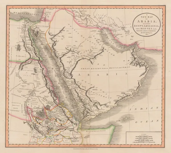
John Cary, A New Map of Arabia, including Egypt, Abyssinia, the Red Sea, &c., 1804£ 2,450.00
-
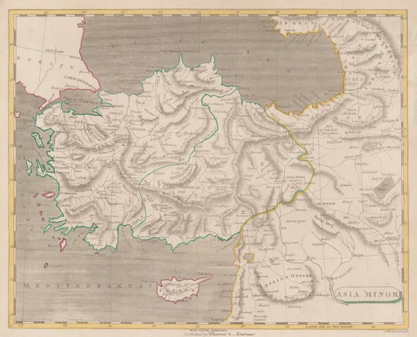
Thomas and Andrews, Asia Minor, 1805£ 145.00
-
Robert Wilkinson, Palaestina seu Terra Sancta, 1806£ 275.00
-
India & the Middle East as it was known during the Classical Era, 1807Robert WilkinsonSeries: LondonRobert Wilkinson, India & the Middle East as it was known during the Classical Era, 1807£ 115.00
-
Robert Wilkinson, Kingdom of Jerusalem, 1807£ 125.00
-
Robert Wilkinson, The Empire of Alexander the Great, 1807£ 145.00
-
Aaron Arrowsmith, Arabia, 1808£ 475.00
-
Aaron Arrowsmith & Samuel Lewis, Persia, 1812£ 125.00
-
Aaron Arrowsmith, Monumental wall map of Iran, 1813£ 4,950.00
-
John Pinkerton, Turkey in Asia, 1813£ 545.00
-
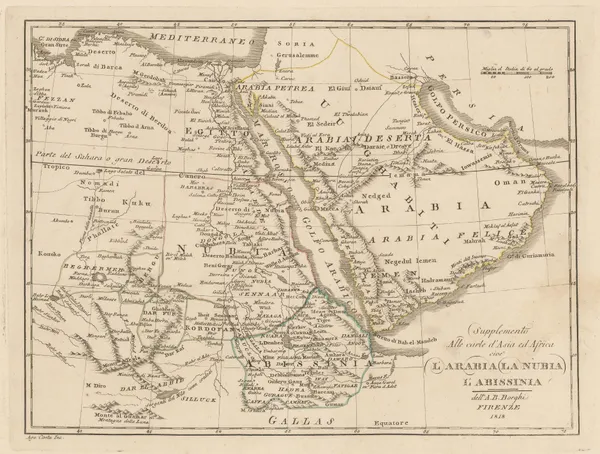
Bartolomeo Borghi, Arabia, Nubia, and Abyssinia, 1818£ 395.00
-
Antoine-Ignace Melling, Bosphorus and Constantinople, 1819£ 1,450.00
-
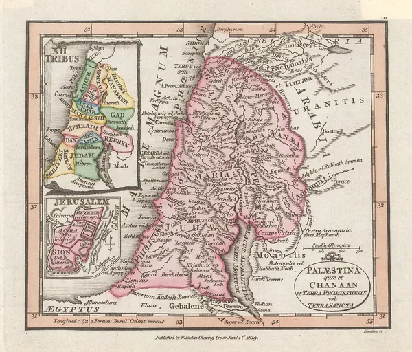
William Faden, Miniature atlas map of the Holy Land, 1819£ 195.00
-
Antoine-Ignace Melling, French plan of Istanbul (Constantinople), 1819£ 2,950.00
-
William Faden, Turkish Dominions in Asia or Asiatic Turkey, 1819£ 125.00
-
Daniel & William Lizars, Persia, 1820 c.£ 295.00
-
Philippe Vandermaelen, Iraq centring on Baghdad, 1827£ 1,150.00
-
Philippe Vandermaelen, Southern Arabia and Yemen, 1827£ 545.00
-
Philippe Vandermaelen, Sinai Peninsula, Jordan, Saudi Arabia and Egypt, 1827£ 750.00


Page
2
of 6