-
 Carl Weiland, Iran, Afghanistan and Beludschistan, 1828£ 345.00
 -
Thomas Starling, Miniature map of the Middle East, 1830£ 115.00
-
Thomas Starling, Turkish Empire, 1830 c.£ 145.00
-
Alexandre Emile Lapie, The Middle East, 1831£ 495.00
-
John Arrowsmith, Turkey in Asia, 1832£ 545.00
-
Charles Smith, Turkey in Asia, 1834£ 175.00
-
Sketch to Illustrate the Paper by E. Stirling Esq, 1835Royal Geographical Society (RGS)Series: LondonRoyal Geographical Society (RGS), Sketch to Illustrate the Paper by E. Stirling Esq, 1835£ 58.00
-
George Washington Boynton, Turkey, Arabia & Persia, 1835 c.£ 145.00
-
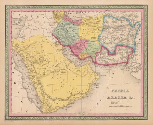
Rest Fenner, Persia and Arabia, 1836£ 98.00
-
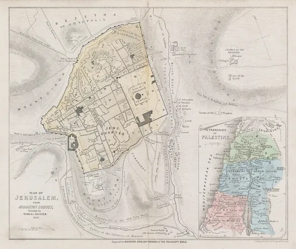
Samuel Bagster, Jerusalem, 1837£ 65.00
-
James Wellsted, Map of Oman in Arabia, 1837£ 3,850.00
-
Royal Geographical Society (RGS), Sketch of The Northern Route from Mokha to Sana, 1838£ 115.00
-
James Wellsted, Mount Sinai Peninsula, 1838£ 395.00
-
Royal Geographical Society (RGS), Sketch map of the Iran and Iraq border, 1839£ 145.00
-
Royal Geographical Society (RGS), Part of Arabia Petraea and Palestine, 1839£ 525.00
-
James Wyld, Map of the Countries lying between Turkey and Burmah, 1839£ 2,450.00
-
Society for the Diffusion of Useful Knowledge (SDUK), Istanbul (Constantinople), 1840£ 485.00
-
A.D. Noel and Louis Vivian de St. Martin, Ottoman Empire, 1840£ 3,250.00
-
Samuel Augustus Mitchell, Arabia, Persia, 1840 c£ 575.00
-
Henry Teesdale, Arabia, Iran (Persia) and Afghanistan (Caubul), 1841£ 375.00
-
John Arrowsmith, Asia Minor or Turkey, 1842£ 445.00
-
Royal Geographical Society (RGS), Sketch of The Kuria-Muria Islands., 1842£ 68.00
-
Topographical Survey of the Plain of Troy with the Ancient Sites, 1842Royal Geographical Society (RGS)Series: LondonRoyal Geographical Society (RGS), Topographical Survey of the Plain of Troy with the Ancient Sites, 1842£ 380.00
-
Robert Wilkinson, Six Chrono-Genealogical Charts of Biblical History, 1842£ 240
-
Robert Wilkinson, Ancient Anatolia, 1842£ 85.00
-
Robert Wilkinson, Syria and Assyria, 1842£ 85.00
-
Robert Wilkinson, The March of the Ten Thousand Greeks, 1842£ 135.00
-
Robert Wilkinson, King Solomon's Twelve Purveyors, 1842£ 85.00
-
Robert Wilkinson, Parthian Empire, 1842£ 125.00
-
Robert Wilkinson, Canaan from the Time of Joshua to the Babylonish Captivity, 1842£ 195.00
-
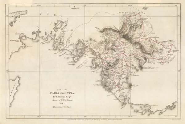
Royal Geographical Society (RGS), Part of Caria and Lycia / Muğla Province, 1843£ 115.00
-
Map to Illustrate Mr. Layard's Paper on Khuzistan, 1846Royal Geographical Society (RGS)Series: LondonRoyal Geographical Society (RGS), Map to Illustrate Mr. Layard's Paper on Khuzistan, 1846£ 98.00
-
Carl Ritter, Jeddah & Environs, 1846£ 895.00
-
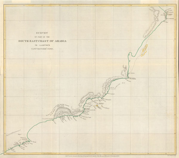
Survey of Part of the South East Coast of Arabia, 1847Royal Geographical Society (RGS)Series: LondonRoyal Geographical Society (RGS), Survey of Part of the South East Coast of Arabia, 1847£ 145.00
-
Joseph Meyer, Karte von Klein Asien, 1848£ 225.00
-
The Shatt el-Arab from Basrah to the Bar of the River Euphrates and the River Karun, 1849Lt. Col. Francis Rawdon ChesneySeries: LondonLt. Col. Francis Rawdon Chesney, The Shatt el-Arab from Basrah to the Bar of the River Euphrates and the River Karun, 1849£ 1,275.00
-
-
-
Joseph Meyer, Anatolia (Turkey) in extraordinary detail, 1850 c.£ 425.00
-
John Tallis, Persia, 1851£ 425.00
-
John Tallis, Turkey in Asia, 1851£ 225.00
-
John Tallis, Asia Minor, 1851£ 225.00
-
Royal Geographical Society (RGS), Map of the Northern Part of Arabia, 1854£ 145.00
-
A New Map of the Frontier Provinces of Turkey, Russia & Austria, the Black Sea &c, 1854Willmer & RogersSeries: New YorkWillmer & Rogers, A New Map of the Frontier Provinces of Turkey, Russia & Austria, the Black Sea &c, 1854£ 550.00
-
Royal Geographical Society (RGS), Palestine, 1854£ 295.00
-
Karl von Spruner, Historical map of the Eastern Caliphate, 1855£ 295.00
-
Sir Archibald Alison, Siege of St. Jean d'Acre, 1855£ 65.00
-
Justus Perthes, Arabia, Ethiopia and Egypt, 1855 c.£ 445.00
-
Royal Geographical Society (RGS), Southern Iraq and Iranian border, 1856£ 145.00
-
Map to Illustrate Notes on Routes from Bushire to Shiraz by Lt. Genl. Monteith and from Shiraz to Darab & thence to Kazerin by Consul Keith E.Abbott, 1857Royal Geographical Society (RGS)Series: LondonRoyal Geographical Society (RGS), Map to Illustrate Notes on Routes from Bushire to Shiraz by Lt. Genl. Monteith and from Shiraz to Darab & thence to Kazerin by Consul Keith E.Abbott, 1857£ 98.00
-
Joseph Hutchins Colton, Middle East, 1858£ 245.00
-
Justus Perthes, Mount Damavand, Iran, 1859£ 95.00
-
Gall & Inglis, Map of Arabia, 1859 c£ 395.00
-
Justus Perthes, Gulf of Aden, 1860£ 225.00
-
Auguste-Henri Dufour, Turkey, Syria, Iraq, Cyprus, the Levant and the Black Sea, 1860£ 225.00
-
John Rapkin, Anatolia (Turkey) Cyprus and Rhodes, 1860 c.£ 82.00
-
Archibald Fullarton, Turkish Empire, 1860 c.£ 285.00
-
John Dower, Turkey in Asia, 1860 c.£ 115.00
-
John Dower, Iran or Persia, 1860 c.£ 175.00
-
Route map from the Persian Gulf to Tehran and Herat, 1861Royal Geographical Society (RGS)Series: LondonRoyal Geographical Society (RGS), Route map from the Persian Gulf to Tehran and Herat, 1861£ 84.00
-
Joseph Hutchins Colton, Arabia, Persia (Iran), Pakistan and Afghanistan, 1861£ 375.00
-
Justus Perthes, Ancient Babylon, 1862£ 95.00
-
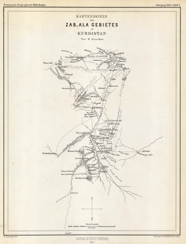
Justus Perthes, Sketch map of Zabala, Kurdistan, 1863£ 68.00
-
Royal Geographical Society (RGS), Map of Syria &c., 1863£ 150.00
-
Royal Geographical Society (RGS), Map of the Island of Kishm, 1864£ 145.00
-
British Admiralty, Chart of the South East Coast of Arabia, 1865£ 3,500.00
-
Royal Geographical Society (RGS), Map of Part of Arabia, 1865£ 485.00
-
Blackie & Son, Syria, 1866£ 78.00
-
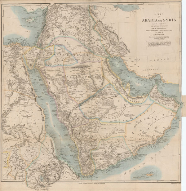
William Gifford Palgrave, Map of Arabia, 1866£ 1,450.00
-
William Gifford Palgrave, Plan of Feysul's Palace in Riyadh , 1866£ 675.00
-
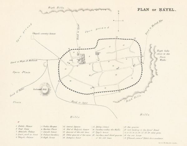
William Gifford Palgrave, Plan of Hayel, 1866£ 445.00
-
Royal Geographical Society (RGS), Persia, Beluchistan and Afghanistan, 1867£ 115.00
-
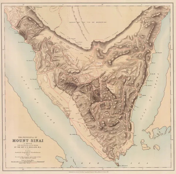
Royal Geographical Society (RGS), Sinai Peninsula, 1868£ 345.00
-
Royal Geographical Society (RGS), Armenia, Kurdistan and Upper Mesopotamia, 1868£ 295.00
-
William Gifford Palgrave, Al-Hofuf, 1869£ 195.00
-
Society for the Diffusion of Useful Knowledge (SDUK), Asia Minor, 1870 c.£ 145.00
-
Royal Geographical Society (RGS), Map of the Southern Coast of Arabia, 1872£ 135.00
-
Justus Perthes, Yemen, 1872£ 245.00
-
Royal Geographical Society (RGS), Route Map of the Tulul el Safa, 1872£ 185.00
-
Royal Geographical Society (RGS), Map of the Vicinity of Aden, 1873£ 175.00


Page
3
of 6