-
 Martin Waldseemüller & Laurent Fries, Crete, 1541£ 1,750.00
 -
Sebastian Münster, Early map of Crete, 1558£ 145.00
-
Sebastian Münster, Nova Graecia, 1572£ 695.00
-
Georg Braun & Frans Hogenberg, Corfu Town & Chania, Crete, 1575 c.£ 1,250.00
-
Tomaso Porcacchi, Early map of Milos, 1576Sold
-
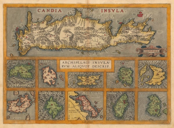
Abraham Ortelius, Crete & the Greek Islands, 1592£ 950.00
-
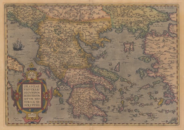
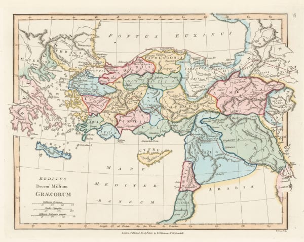
Abraham Ortelius, Greece during the Classical period, 1592£ 2,250.00
-
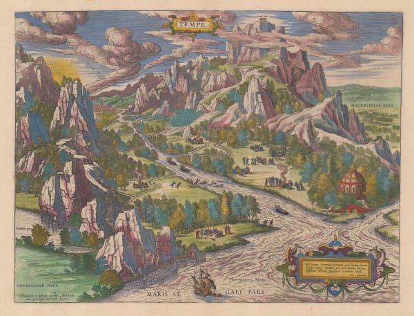
Abraham Ortelius, Map of Tempe and Mount Olympus, 1595£ 1,250.00
-
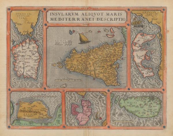
Abraham Ortelius, Sicily, Sardinia, Corfu, Malta, Elba, & Djerba, 1598£ 850.00
-
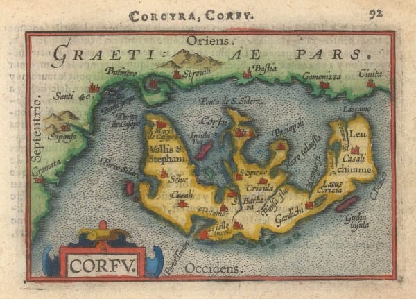
Abraham Ortelius, Miniature map of Corfu, 1601Sold
-
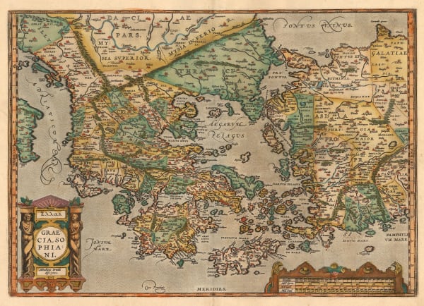
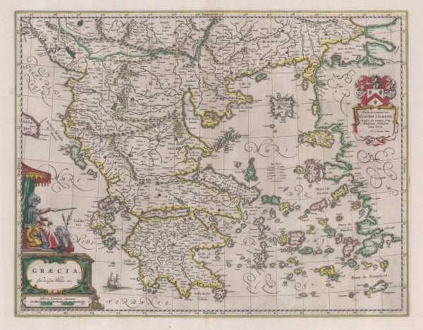
Abraham Ortelius, First atlas map of Greece, 1603£ 2,700.00
-
Petrus Bertius, Miniature map of Greece, 1616Sold
-
Samuel Purchas, Crete, Corfu, Zante, Milos, Naxos & Karpathos, 1625£ 425.00
-
Mercator Hondius, Crete, Corfu, Zante, Milos, Naxos, Santorini & Karpathos, 1628Sold
-
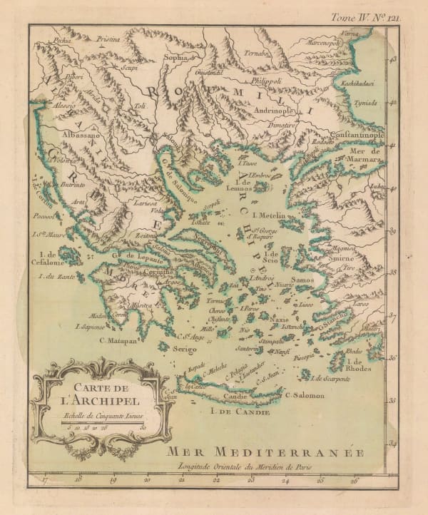
Mercator Hondius, Crete, Corfu, Zante, Milos, Naxos, Santorini & Karpathos, 1630 c.£ 725.00
-
Mercator Hondius, Greece, 1636£ 885.00
-
Jan Jansson, Thrace during the Classical period, 1640 c.£ 625.00
-
Willem & Jan Blaeu, The Peloponnese, 1650 c.£ 595.00
-
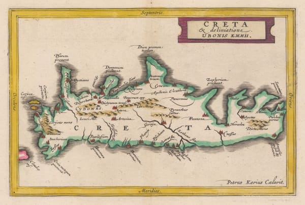
Jan Jansson, Ancient Crete, 1661£ 245.00
-
Jan Jansson, Ancient Greece, 1661£ 325.00
-
Jan Jansson, Ancient Thrace, 1661£ 175.00
-
Willem & Jan Blaeu, Cyclades & Dodecanese Islands, 1662£ 1,750.00
-
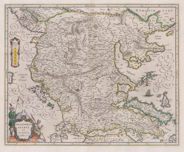
Jan Jansson, Macedonia, 1662£ 695.00
-
Willem & Jan Blaeu, Attica, Macedonia, Epirus, and Thessaly, 1662£ 575.00
-
Jan Jansson, Greek province of Thessaly, 1662£ 625.00
-
Willem & Jan Blaeu, Crete, 1662 (c.)£ 345.00
-
Willem & Jan Blaeu, Dutch Golden Age map of Greece, 1662 (c.)£ 1,250.00
-
Willem & Jan Blaeu, Northern Aegean Islands, 1662 (c.)£ 950.00
-
Philipp Cluver, Central Greece and Attica, 1672Sold
-
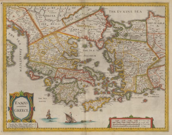
John Speed, Greece, 1676£ 2,850.00
-
Nicolas Sanson, Greece and the Aegean, 1679£ 145.00
-
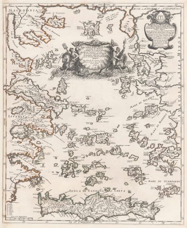
Giovanni Giacomo Rossi, Aegean Sea, 1684£ 1,850.00
-
Robert Morden, Miniature map of Greece, 1688Sold
-
Vincenzo Coronelli, Cyclades, Dodecanese & Southern Aegean Islands, 1692£ 1,200.00
-
Vincenzo Coronelli, Athens during the Classical period, 1692£ 1,350.00
-
Vincenzo Coronelli, Northern Aegean Sea, 1692 c.£ 950.00
-
Vincenzo Coronelli, Corfu, Paxos & Antipaxos, 1696£ 785.00
-
Vincenzo Coronelli, Chart of the southern coast of the Peloponnese, 1696£ 425.00
-
Vincenzo Coronelli, Sea chart of Crete, 1696£ 845.00
-
Vincenzo Coronelli, Rhodes, 1696£ 475.00
-
Vincenzo Coronelli, Crete, 1696£ 1,850.00
-
Philipp Cluver, The Peloponnese during the classical period, 1697Sold
-
Nicolas Sanson, Partie de Turquie en Europe, 1700£ 275.00
-
Olfert Dapper, The City and Harbour of Rhodes, 1702£ 375.00
-
Pieter van der Aa, Corfu, 1714Sold
-
Pieter van der Aa, The Island of Euboea, 1714Sold
-
Alain Manesson Mallet, Corfu, 1719£ 295.00
-
Johann Christoph Homann, Attica and Boeotia, 1720 c.£ 525.00
-
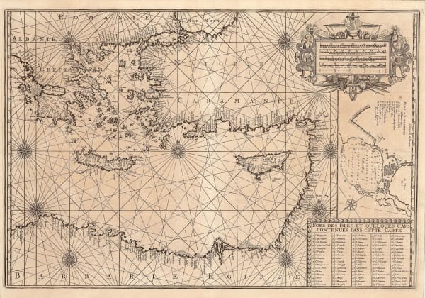
Henri Michelot and Laurent Brémond, Chart of the Aegean Sea, 1726£ 2,250.00
-
Henri Michelot and Laurent Brémond, Eastern Mediterranean Sea Chart, 1726£ 2,650.00
-
Georges-Louis Le Rouge, Greece, 1746£ 125.00
-
Tobias Conrad Lotter, Greece and the Aegean Sea, 1760 c.£ 645.00
-
Jacques-Nicolas Bellin, Greece and the Peloponnese, 1764£ 145.00
-
Joseph Roux, Corfu, 1764£ 185.00
-
Jacques-Nicolas Bellin, Plan of Chania, Crete, 1764£ 125.00
-
Jacques-Nicolas Bellin, Plan of Heraklion, Crete, 1764£ 125.00
-
Greece, the Aegean Sea, the Greek Archipelago and western Anatolia, 1764Jacques-Nicolas BellinSeries: FranceJacques-Nicolas Bellin, Greece, the Aegean Sea, the Greek Archipelago and western Anatolia, 1764£ 195.00
-
Jacques-Nicolas Bellin, Crete, 1764£ 245.00
-
Jacques-Nicolas Bellin, Southern Greece, 1764£ 195.00
-
Homann Heirs, Albania, North Macedonia, Northern Greece , 1770£ 525.00
-
Antonio Zatta, Northern Greece, 1781£ 225.00
-
William Faden, Greece and part of Anatolia, 1791£ 1,185.00
-
Robert Wilkinson, Ancient Greece, 1796£ 95.00
-
Pierre Tardieu, Corfu, 1802 c.£ 325.00
-
Robert Wilkinson, Central Greece in Ancient Times, 1805£ 145.00
-
C.V. Lavoisne, Geographical and Historical Map of Greece, 1813£ 245.00
-
John Thomson, Attica, 1815 c.£ 175.00
-
Richard Holmes Laurie, Ancient Greece, 1820£ 625.00
-
John Thomson, Greece prior to Independence, 1820 (c.)£ 225.00
-
J.C. & J.A. Dezauche, Important map of Greece, 1826£ 895.00
-
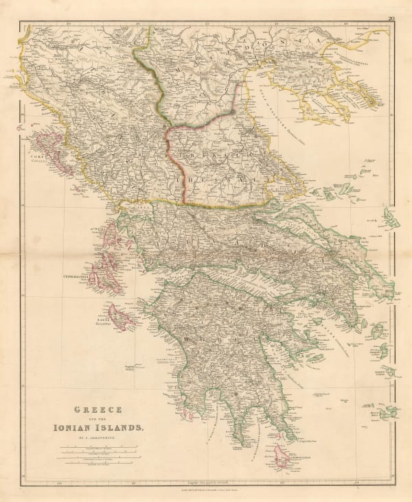
John Arrowsmith, Greece and the Ionian Islands, 1832£ 395.00
-
Rest Fenner, Greece, 1836£ 68.00
-
Rest Fenner, The Peloponnese Peninsula, 1836£ 64.00
-
Royal Geographical Society (RGS), Ancient settlements of Minoa and Nisea, 1837Sold
-
Robert Wilkinson, The March of the Ten Thousand Greeks, 1842£ 135.00
-
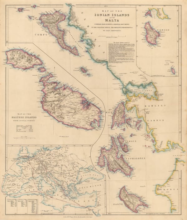
John Arrowsmith, Map of the Ionian Islands and Malta, 1844£ 325.00
-
Society for the Diffusion of Useful Knowledge (SDUK), Ancient Athens, 1844£ 325.00
-
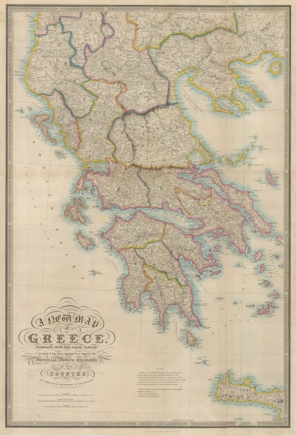
James Wyld, Ancient and modern Greece, 1850 c.£ 545.00
-
John Tallis, Ionian Isles and Greece, 1851£ 150.00
-
John Tallis, British Possessions on the Mediterranean, 1851£ 395.00


Page
1
of 2