-
 Johann Ulrich Muller, Miniature map of France, 1692£ 150.00
 -
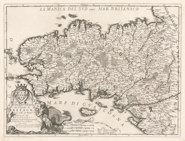
Domenico & Giuseppe Rossi, Brittany, 1692£ 645.00
-
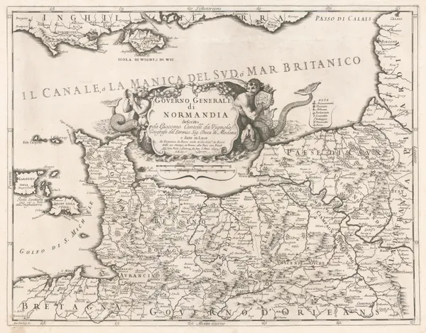
Domenico & Giuseppe Rossi, Normandy, 1692£ 545.00
-
Alexis-Hubert Jaillot, Provence, 1692£ 950.00
-
Vincenzo Coronelli, Chart of the Riviera from Cabo di Mello to San Sebastian, 1696£ 725.00
-
Alexis-Hubert Jaillot, Provence, 1696£ 1,350.00
-
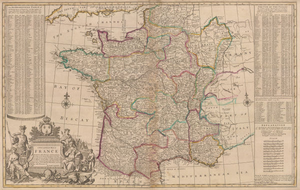
Nicolas Sanson, France, 1700£ 350.00
-
Alexis-Hubert Jaillot, Marseille, 1700 c.£ 155.00
-
Alexis-Hubert Jaillot, Toulon, 1700 c.£ 155.00
-
Nicolas de Fer, Bourges, Centre-Val de Loire, 1705£ 235.00
-
Nicolas de Fer, City plan of Dijon, 1705£ 220.00
-
Nicolas de Fer, Savoy, 1705£ 385.00
-
Nicolas de Fer, Britanny, 1705£ 325.00
-
Nicolas de Fer, Provence, 1705£ 345.00
-
Nicolas de Fer, Normandy, 1705£ 295.00
-
Nicolas de Fer, Languedoc, 1705£ 225.00
-
Nicolas de Fer, Southwest France, 1705£ 725.00
-
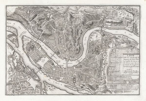
Nicolas de Fer, Lyon, 1705£ 195.00
-
Pierre Mortier, Chart of the coast of Normandy and Brittany, 1708£ 750.00
-
Pierre Mortier, Chart of the coast of Finistère, 1708£ 850.00
-
Pierre Mortier, Chart of the mouth of the Loire River, 1708£ 850.00
-
Pierre Mortier, Western coast of France from Gironde River to Noirmoutier, 1708£ 950.00
-
Romeyn De Hooghe, West coast of France with Isle d'Oleron and Isle de Re, 1708£ 2,500.00
-
Chart of the southwest coast from Bordeaux river to St. Sebastian, 1708Romeyn De HoogheSeries: AmsterdamRomeyn De Hooghe, Chart of the southwest coast from Bordeaux river to St. Sebastian, 1708£ 3,000.00
-
Romeyn De Hooghe, Chart of the coast around Dieppe, Normandy, 1708£ 985.00
-
Pierre Mortier, South eastern coast of the Bay of Biscay, 1708£ 850.00
-
Nicolas de Fer, Savoie & the French Alps, 1709£ 585.00
-
Johann Baptist Homann, Provence, 1710 c.£ 950.00
-
Pieter van der Aa, Languedoc, 1713£ 295.00
-
Pieter van der Aa, France, 1713£ 325.00
-
Pieter van der Aa, Province of Artois, Pas-de-Calais, 1714£ 275.00
-
Pieter van der Aa, Franche-Comté, 1714£ 250.00
-
Pieter van der Aa, Île-de-France, 1714£ 300.00
-
Pieter van der Aa, Champagne, 1714£ 225.00
-
Pieter van der Aa, Alsace, 1714£ 245.00
-
Pieter van der Aa, France, 1714£ 345.00
-
Henri Michelot and Laurent Brémond, Chart of the Bay of Marseilles, 1720£ 1,350.00
-
Johann Georg Schreiber, Provence, 1720 c.£ 325.00
-
Christoph & Johann Christoph Weigel, France, 1720 c.£ 245.00
-
Josua & Reinier Ottens, Normandy, 1720 c.£ 575.00
-
Nicolas de Fer, Paris, 1729£ 950.00
-
Herman Moll, France, 1730 c£ 2,550.00
-
Covens (Jean) & Mortier (Cornelius), Normandy, 1730 c.£ 450.00
-
Covens (Jean) & Mortier (Cornelius), Burgundy, 1730 c.£ 225.00
-
Covens (Jean) & Mortier (Cornelius), Provence, 1730 c.£ 425.00
-
Covens (Jean) & Mortier (Cornelius), Normandy, 1730 c.£ 195.00
-
Covens (Jean) & Mortier (Cornelius), Calais, Dunkirk and Veurne, 1730 c.£ 150.00
-
Covens (Jean) & Mortier (Cornelius), France, 1730 c.£ 245.00
-
Covens (Jean) & Mortier (Cornelius), Languedoc, 1730 c.£ 295.00
-
Covens (Jean) & Mortier (Cornelius), Northern Champagne, 1730 c.£ 450.00
-
Covens (Jean) & Mortier (Cornelius), Picardy, Hauts-de-France, 1730 c.£ 180.00
-
Homann Heirs, City plan and panorama of Strasbourg, 1734£ 1,250.00
-
Johannes Ratelband, Paris, 1735 c.£ 225.00
-
Homann Heirs, Paris and environs, 1739£ 1,550.00
-
Paul de Rapin & Nicolas Tindal, Battle of Malplaquet, 1740 c.£ 325.00
-
Homann Heirs, Provence, 1740 c.£ 575.00
-
Matthaus Seutter, Paris, 1740 c.£ 1,500.00
-
Homann Heirs, Normandy, 1740 c.£ 445.00
-
Paul de Rapin & Nicolas Tindal, Siege map of Toulon, 1740 c.£ 80.00
-
Herman Moll, France, 1745£ 115.00
-
Philippe Buache, Armagnac, 1745£ 395.00
-
Matthaus Seutter, Provence, 1745 c.£ 725.00
-
Jacques Ayrouard, Bay of Villefranche, Provence, 1746£ 545.00
-
Jacques Ayrouard, Chart of the Bay of the Isles D'Hieres, Côte d'Azur, 1746£ 485.00
-
Jacques Ayrouard, Chart of the French Riviera coast from Cannes to Antibes, 1746£ 395.00
-
Jacques Ayrouard, Chart of the bay and port of Toulon, 1746£ 345.00
-
Jacques Ayrouard, Chart of the Isles of St. Marguerite, Provence, 1746£ 395.00
-
Georges-Louis Le Rouge, Île-de-France, 1748£ 65.00
-
Georges-Louis Le Rouge, Savoy, 1748£ 145.00
-
Georges-Louis Le Rouge, Isle de Re, 1748 c.£ 185.00
-
Robert de Vaugondy, Burgundy and Franche-Comté, 1749£ 135.00
-
Johann Georg Schreiber, France, 1749£ 145.00
-
Mount & Page, Bay of Biscay from Olonne to Bermeo, 1750 c.£ 495.00
-
Robert de Vaugondy, Champagne-Ardenne, 1753£ 185.00
-
Herman Moll, France, 1755 c.£ 145.00
-
Georges-Louis Le Rouge, Brittany, 1756£ 95.00
-
London Magazine, The Cotentin Peninsula, Normandy, 1758£ 60.00
-
Covens (Jean) & Mortier (Cornelius), France, 1758 c.£ 575.00
-
London Magazine, A Map of Bell'Isle, 1761£ 95.00
-
Robert de Vaugondy, Northern France, 1762£ 70.00


Page
2
of 7