-
 Christopher & John Greenwood, Map of the County of Derby, 1825£ 1,550.00
 -
Christopher & John Greenwood, Map of the County of Essex, From an Actual Survey, 1825£ 3,750.00
-
William Kemp, Pontefract Race Course, 1825£ 82.00
-
J. & G. Todd, York, 1825£ 245.00
-
Andrew Bryant, Map of the County of Buckingham from actual Survey, 1825£ 3,500.00
-
William Darton, Kent divided into its Hundreds, 1825 c£ 175.00
-
Christopher & John Greenwood, A Map of Northampton, 1826£ 1,250.00
-
Christopher & John Greenwood, Map of County Dorset, 1826£ 3,500.00
-
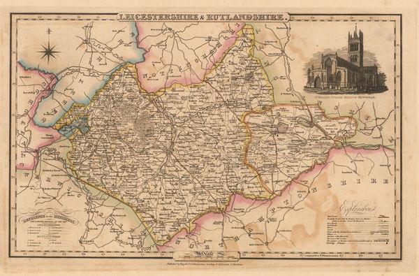
Christopher & John Greenwood, Map of the County of Leicester, 1826£ 1,250.00
-
Andrew Bryant, Map of the County of Norfolk, from Actual Survey, 1826£ 3,500.00
-
Andrew Bryant, Map of the County of Suffolk from Actual Survey, 1826£ 4,750.00
-
Christopher & John Greenwood, Hampshire, 1826£ 3,500.00
-
Christopher & John Greenwood, A Map of the County of Devon, 1827£ 3,750.00
-
John Wilkes, Somersetshire, 1827£ 75.00
-
John Wilkes, Staffordshire, 1827£ 72.00
-
John Wilkes, Sussex, 1827£ 125.00
-
John Piggott-Smith, Brimingham, 1828£ 2,450.00
-
John Wilkes, Warwickshire, 1828£ 75.00
-
John Wilkes, Wiltshire, 1828£ 88.00
-
John Wilkes, Worcestershire, 1828£ 82.00
-
Henry Teesdale, Wall Map of Yorkshire, 1828£ 2,750.00
-
Christopher & John Greenwood, Map of the County of Berks., 1829£ 650.00
-
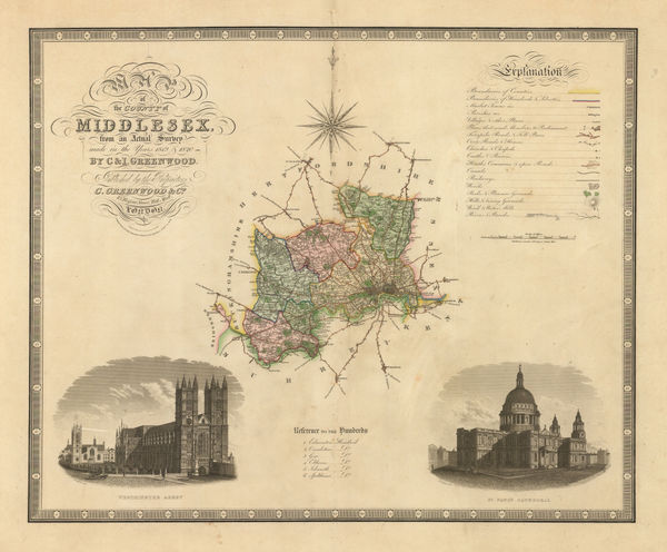
Christopher & John Greenwood, Map of the County of Middlesex, 1829£ 475.00
-
Christopher & John Greenwood, Map of the County of Surrey, 1829£ 525.00
-
Christopher & John Greenwood, Map of the County of Sussex, 1829£ 850.00
-
Andrew Bryant, Map of the East Riding of Yorkshire from Actual Survey, 1829£ 2,750.00
-
Christopher & John Greenwood, Map of the County of Cornwall, 1829£ 975.00
-
Christopher & John Greenwood, Map of the County of Wiltshire, 1829£ 745.00
-
Christopher & John Greenwood, Hampshire, 1829£ 695.00
-
Christopher & John Greenwood, Map of the County of Somerset from an Actual Survey, 1829£ 725.00
-
A Map of the County of Northampton from an Actual Survey, 1830Christopher & John GreenwoodSeries: LondonChristopher & John Greenwood, A Map of the County of Northampton from an Actual Survey, 1830£ 395.00
-
George Hennet, A Map of the County Palatine of Lancaster, 1830£ 2,250.00
-
John Murray, Lincolnshire, 1830£ 85.00
-
Map of the County of Cumberland from an Actual Survey, 1830Christopher & John GreenwoodSeries: LondonChristopher & John Greenwood, Map of the County of Cumberland from an Actual Survey, 1830£ 350.00
-
Christopher & John Greenwood, Map of the County of Leicester, 1830£ 495.00
-
Christopher & John Greenwood, Map of the County of Stafford, 1830£ 385.00
-
Christopher & John Greenwood, Map of the County of Warwick, 1830£ 450.00
-
Christopher & John Greenwood, Map of the County of Westmoreland, 1830£ 395.00
-
Christopher & John Greenwood, Map of the County of Worcester, 1830£ 450.00
-
Christopher & John Greenwood, Map of the County Palatine of Chester, 1830£ 485.00
-
Christopher & John Greenwood, Map of the County Palatine of Lancashire, 1830£ 685.00
-
Henry Teesdale, A Map of the County Palatine of Chester, 1830£ 1,550.00
-
Christopher & John Greenwood, Bristol and Environs, 1830 (c.)£ 150.00
-
Cole & Roper, Hertfordshire, 1830 c£ 82.00
-
Henry Teesdale, Cheshire, 1830 c.£ 95.00
-
James Pigot, Cumberland, 1830 c.£ 85.00
-
Henry Teesdale, Cumberland, 1830 c.£ 95.00
-
Henry Teesdale, England and Wales, 1830 c.£ 295.00
-
Henry Teesdale, Leicestershire, 1830 c.£ 70.00
-
James Pigot, Leicestershire and Rutlandshire, 1830 c.£ 58.00
-
Henry Teesdale, Lincolnshire, 1830 c.£ 125.00
-
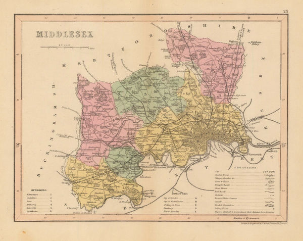
Joshua Archer, Middlesex, 1830 c.£ 44.00
-
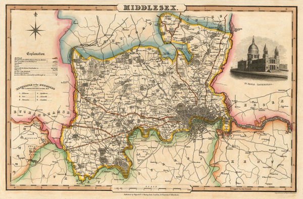
Isaac Slater, Middlesex, 1830 c.£ 180.00
-
Robert Seaton, New Map of England and Wales, 1830 c.£ 3,500.00
-
Henry Teesdale, Northampton, 1830 c.£ 88.00
-
Isaac Slater, Northamptonshire, 1830 c.£ 78.00
-
James Pigot, Nottinghamshire, 1830 c.£ 88.00
-
James Pigot, Shropshire, 1830 c.£ 68.00
-
Henry Teesdale, Staffordshire, 1830 c.£ 115.00
-
James Pigot, Surrey, 1830 c.£ 175.00
-
Thomas Moule, Worcestershire, 1830 c.£ 85.00
-
James Pigot, Worcestershire, 1830 c.£ 110.00
-
Henry Teesdale, Glocestershire, 1830 c.£ 160.00
-
James Pigot, Warwickshire, 1830 c.£ 115.00
-
James Pigot, Devonshire, 1830 c.£ 175.00
-
Map of the County of Bedford from an Actual Survey by C. & J. Greenwood, 1831Christopher & John GreenwoodSeries: LondonChristopher & John Greenwood, Map of the County of Bedford from an Actual Survey by C. & J. Greenwood, 1831£ 395.00
-
Christopher & John Greenwood, Map of the County of Durham, 1831£ 525.00
-
Map of the County of Essex from an Actual Survey made in the Year 1824, 1831Christopher & John GreenwoodSeries: LondonChristopher & John Greenwood, Map of the County of Essex from an Actual Survey made in the Year 1824, 1831£ 675.00
-
Christopher & John Greenwood, Map of the County of Gloucester, 1831£ 625.00
-
Christopher & John Greenwood, Map of the County of Huntingdon, 1831£ 275.00
-
Christopher & John Greenwood, Map of the County of Lincoln, 1831£ 495.00
-
Map of the County of Nottingham from an Actual Survey, 1831Christopher & John GreenwoodSeries: LondonChristopher & John Greenwood, Map of the County of Nottingham from an Actual Survey, 1831£ 325.00
-
Christopher & John Greenwood, Map of the County of Rutland, 1831£ 300.00
-
Christopher & John Greenwood, Map of the County of Suffolk, 1831£ 650.00
-
Thomas Oliver, Newcastle & Gateshead, 1831£ 2,250.00
-
Henry Teesdale, A Map of the County of Stafford, 1832£ 985.00
-
Robert Kearsley Dawson, Cambridge, 1832£ 58.00
-
Robert Kearsley Dawson, Gloucester, 1832£ 38.00
-
Robert Kearsley Dawson, Great Yarmouth, 1832£ 30.00
-
Robert Kearsley Dawson, Lancaster, 1832£ 30.00


Page
9
of 15