-
 Robert Kearsley Dawson, Poole, 1832£ 62.00
 -
Robert Kearsley Dawson, Stockport, 1832£ 30.00
-
George & John Cary, London & the Home Counties, 1832£ 1,450.00
-
Charles Godwin, Bath, 1833£ 550.00
-
Cary's Six Sheet Map of England and Wales, with part of Scotland, 1833George & John CarySeries: LondonGeorge & John Cary, Cary's Six Sheet Map of England and Wales, with part of Scotland, 1833£ 850.00
-
Joshua Archer, Westmoreland, 1833£ 20.00
-
John Walter Froggett, Froggett's Survey of the Country Thirty Miles Round London, 1833£ 3,950.00
-
James Gardner, First Edition O.S. Map of Bicester and Environs, 1833 c.£ 195.00
-
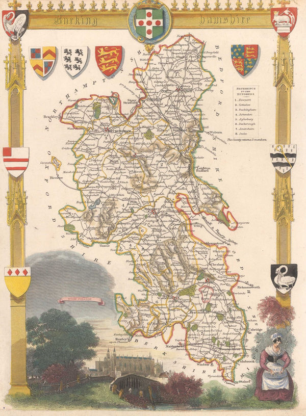
Christopher & John Greenwood, Map of the County of Buckingham, 1834£ 595.00
-
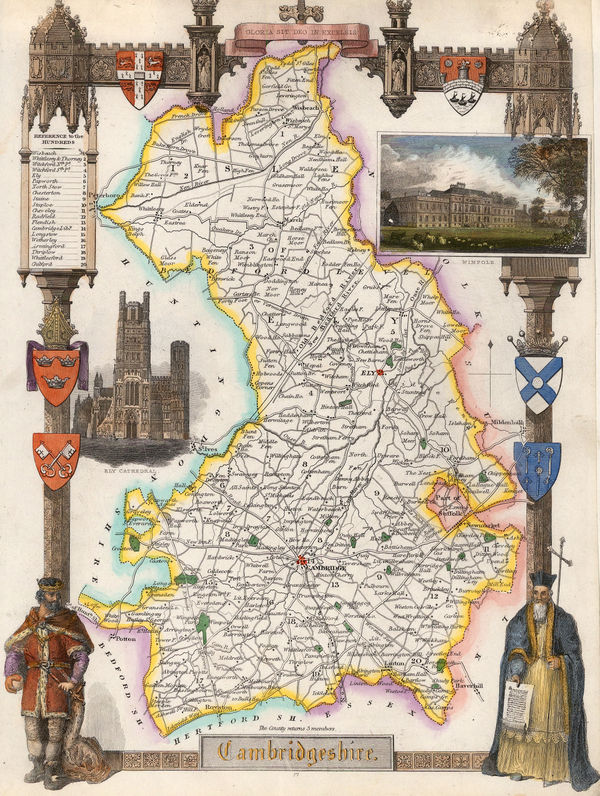
Christopher & John Greenwood, Map of the County of Cambridge, 1834£ 450.00
-
Christopher & John Greenwood, Map of the County of Hereford, 1834£ 325.00
-
Christopher & John Greenwood, Map of the County of Hertford, 1834£ 495.00
-
Christopher & John Greenwood, Map of the County of Norfolk, 1834£ 520.00
-
Christopher & John Greenwood, Map of the East Riding of the County of York, 1834£ 385.00
-
Christopher & John Greenwood, Map of the North Riding of the County of York, 1834£ 575.00
-
Christopher & John Greenwood, Map of the West Riding of the County of York, 1834£ 675.00
-
J. & C. Walker, Gloucestershire, 1835£ 125.00
-
J. & C. Walker, Kent, 1835£ 72.00
-
Edward Mogg, New Map of England and Wales with Part of Scotland, 1835£ 1,350.00
-
J. & C. Walker, Somerset, 1835£ 150.00
-
Henry Teesdale, Derbyshire, 1835 c.£ 85.00
-
Henry Teesdale, Durham, 1835 c.£ 115.00
-
Henry Teesdale, Hertfordshire, 1835 c.£ 125.00
-
James Pigot, Staffordshire, 1835 c.£ 90.00
-
Henry Teesdale, Warwickshire, 1835 c.£ 95.00
-
J. & C. Walker, Cumberland, 1836£ 68.00
-
J. & C. Walker, Durham, 1836£ 82.00
-
J. & C. Walker, East Riding of Yorkshire, 1836£ 72.00
-
J. & C. Walker, A Geological Map of England, Wales, and Part of Scotland, 1837£ 4,500.00
-
J. & C. Walker, Sussex, 1837£ 145.00
-
John Le Keux, Oxford, 1837£ 95.00
-
Commencement of the Roads to Holyhead, as far as (13) Stratford on Avon, Warwick, Coventry & Hinckley, 1838Richard Holmes LaurieSeries: LondonRichard Holmes Laurie, Commencement of the Roads to Holyhead, as far as (13) Stratford on Avon, Warwick, Coventry & Hinckley, 1838£ 45.00
-
Josiah Henshall, Tunbridge Wells, 1838£ 650.00
-
John Colbran, Tunbridge Wells, 1839£ 250.00
-
Ordnance Survey, 20 Miles Around Chesterfield, 1839£ 295.00
-
Society for the Diffusion of Useful Knowledge (SDUK), Birmingham, 1839 c.£ 88.00
-
Samuel Lewis, A Map of England and Wales, 1840£ 1,450.00
-
James Pigot, Cheshire, 1840£ 115.00
-
James Pigot, Cornwall, 1840£ 225.00
-
James Pigot, Derbyshire, 1840£ 92.00
-
J. & C. Walker, England and Wales, 1840£ 1,250.00
-
James Pigot, Lancashire, 1840£ 155.00
-
William Colling Hobson, Map of the County Palatine of Durham, 1840£ 950.00
-
James Pigot, Northumberland, 1840£ 115.00
-
James Pigot, Suffolk, 1840£ 145.00
-
James Pigot, Somersetshire, 1840£ 185.00
-
James Pigot, Berkshire, 1840£ 185.00
-
Isaac Slater, Hertfordshire, 1840£ 135.00
-
Thomas Moule, Bedfordshire, 1840 c.£ 80.00
-
James Pigot, Bedfordshire, 1840 c.£ 85.00
-
Thomas Moule, Berk Shire, 1840 c.£ 125.00
-
John Dower, Birmingham, 1840 c.£ 95.00
-
Thomas Moule, Buckinghamshire, 1840 c.£ 110.00
-
Thomas Moule, Cambridgeshire, 1840 c.£ 145.00
-
Samuel Lewis, Cambridgeshire, 1840 c.£ 35.00
-
Thomas Moule, Cornwall, 1840 c.£ 195.00
-
Thomas Moule, Devonshire, 1840 c.£ 175.00
-
Thomas Moule, Dorsetshire, 1840 c.£ 98.00
-
Thomas Moule, Durham, 1840 c.£ 95.00
-
James Pigot, Durham, 1840 c.£ 95.00
-
Samuel Lewis, Essex, 1840 c.£ 68.00
-
Isaac Slater, Essex, 1840 c.£ 125.00
-
James Pigot, Gloucestershire, 1840 c.£ 145.00
-
Thomas Moule, Hampshire, 1840 c.£ 185.00
-
Thomas Moule, Herefordshire, 1840 c.£ 68.00
-
Thomas Moule, Huntingdonshire, 1840 c.£ 45.00
-
Thomas Moule, Isle of Wight, 1840 c.£ 135.00
-
Samuel Lewis, Kent, 1840 c.£ 68.00
-
Thomas Moule, Lancashire, 1840 c.£ 175.00
-
Thomas Moule, Leicestershire, 1840 c.£ 95.00
-
Samuel Lewis, Leicestershire, 1840 c.£ 40.00
-
Thomas Moule, Lincolnshire, 1840 c.£ 118.00
-
James Pigot, Norfolk, 1840 c.£ 175.00
-
Thomas Moule, Oxfordshire, 1840 c.£ 145.00
-
Thomas Moule, Boston, 1840 c.£ 65.00
-
Thomas Moule, Rutlanshire, 1840 c.£ 68.00
-
Thomas Moule, Shropshire, 1840 c.£ 85.00
-
Thomas Moule, Somersetshire, 1840 c.£ 118.00
-
Thomas Moule, Staffordshire, 1840 c.£ 115.00
-
Thomas Moule, Surrey, 1840 c.£ 245.00


Page
10
of 15