-
 Richard Warner, Plan of the City of Bath A.D.1717, 1801£ 525.00
 -
John Cary, A Map of Wiltshire, 1801£ 325.00
-
John Cary, A New Map of Surrey, 1801£ 595.00
-
John Cary, A New Map of Northamptonshire, 1801£ 275.00
-
John Wilkes, Bedfordshire, 1802£ 65.00
-
John Wilkes, Cambridgeshire, 1802£ 88.00
-
John Wilkes, Cumberland, 1802£ 75.00
-
Charles Smith, The Lake District, 1802£ 485.00
-
John Wilkes, Cornwall, 1802£ 115.00
-
John Wilkes, Derbyshire, 1802£ 145.00
-
John Wilkes, Essex, 1803£ 95.00
-
John Cary, Map of England and Wales, 1803£ 485.00
-
Charles Smith, A New Map of the County of Cornwall, 1804£ 395.00
-
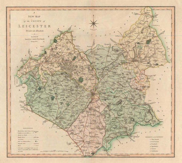
Charles Smith, A New Map of the County of Leicester, 1804£ 90.00
-
Charles Smith, A New Map of the County of Nottingham, 1804£ 150.00
-
Cole & Roper, Berkshire, 1804£ 88.00
-
John Cary, A Map of Essex from the Best Authorities, 1805£ 175.00
-
A Map of the Principal Roman Camps, Forts and Walls & c between the River Tyne in England and Tay in Scotland, 1805John CarySeries: LondonJohn Cary, A Map of the Principal Roman Camps, Forts and Walls & c between the River Tyne in England and Tay in Scotland, 1805£ 145.00
-
John Cary, A New Map of Oxfordshire, 1805£ 425.00
-
Cole & Roper, Cheshire, 1805£ 68.00
-
Cole & Roper, Cumberland, 1805£ 78.00
-
Cole & Roper, Derbyshire, 1805£ 45.00
-
Cole & Roper, Durham, 1805£ 72.00
-
Cole & Roper, Gloucester, 1805£ 95.00
-
John Wilkes, Glocestershire, 1805£ 115.00
-
John Cary, Map of Bedfordshire from the Best Authorities, 1805£ 145.00
-
John Cary, Map of Buckinghamshire from the Best Authorities, 1805£ 175.00
-
John Cary, Map of Cambridgeshire from the Best Authorities, 1805£ 155.00
-
John Cary, Map of Durham from the Best Authorities, 1805£ 160.00
-
Map of East Riding of Yorkshire with Ainsty Liberty from the Best Authorities, 1805John CarySeries: LondonJohn Cary, Map of East Riding of Yorkshire with Ainsty Liberty from the Best Authorities, 1805£ 195.00
-
John Cary, Map of Essex from the Best Authorities, 1805£ 295.00
-
John Cary, Map of Hertfordshire from the Best Authorities, 1805£ 245.00
-
John Cary, Map of Lancashire from the Best Authorities, 1805£ 275.00
-
John Cary, Map of Lincolnshire from the Best Authorities, 1805£ 225.00
-
John Cary, Map of Northamptonshire from the Best Authorities, 1805£ 225.00
-
John Cary, Map of Staffordshire from the Best Authorities, 1805£ 165.00
-
John Cary, Map of Suffolk from the Best Authorities, 1805£ 325.00
-
John Cary, Map of Surrey from the Best Authorities, 1805£ 375.00
-
John Cary, Map of Sussex from the Best Authorities, 1805£ 345.00
-
John Cary, Map of Worcestershire from the Best Authorities, 1805£ 175.00
-
John Cary, Map of Dorsetshire from the Best Authorities, 1805£ 275.00
-
John Cary, A Map of Berkshire, 1805£ 375.00
-
Cole & Roper, Winchester, 1805£ 125.00
-
John Cary, A New Map of Staffordshire, 1806£ 295.00
-
John Cary, A New Map of Warwickshire, 1806£ 325.00
-
Cole & Roper, Hereford, 1806£ 55.00
-
John Wilkes, Hertfordshire, 1806£ 78.00
-
John Cary, A New Map of Lancashire, 1806£ 445.00
-
A New Map of Devonshire divided into Hundreds exhibiting its Roads, Rivers, Parks &c., 1807John CarySeries: LondonJohn Cary, A New Map of Devonshire divided into Hundreds exhibiting its Roads, Rivers, Parks &c., 1807£ 495.00
-
Samuel John Neele, Cheshire, 1807£ 80.00
-
Cole & Roper, Herefordshire, 1807£ 62.00
-
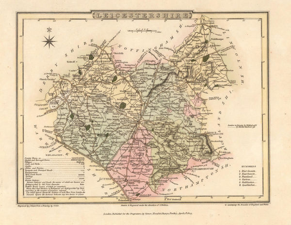
Cole & Roper, Leicestershire, 1807£ 70.00
-
Cole & Roper, Norwich, 1807£ 115.00
-
Cole & Roper, Warwickshire, 1807£ 55.00
-
Cole & Roper, Westmoreland, 1807£ 62.00
-
John Albin, The Isle of Wight, 1807£ 1,150.00
-
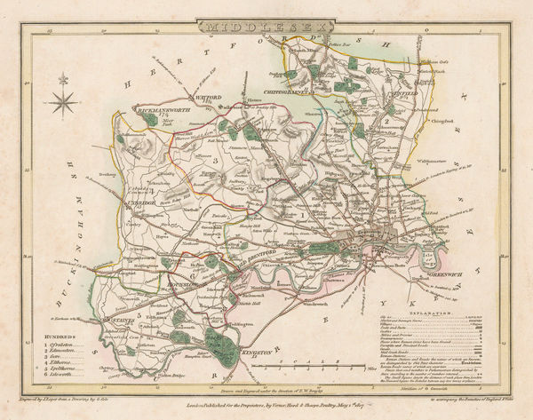
Cole & Roper, Middlesex, 1807£ 55.00
-
John Cary, A New Map of Cambridgeshire, 1808£ 245.00
-
Charles Smith, A New Map of the County of Durham Divided into Wards, 1808£ 145.00
-
Charles Smith, A New Map of the County of Gloucestershire, 1808£ 195.00
-
Charles Smith, A New Map of the County of Surrey, 1808£ 285.00
-
Charles Smith, A New Map of the County of Sussex, 1808£ 245.00
-
Charles Smith, A New Map of the County Palatine of Cheshire, 1808£ 145.00
-
Charles Smith, A New Map of Yorkshire, 1808£ 595.00
-
Richard Phillips, Berkshire, 1808£ 40.00
-
Richard Phillips, Cumberland, 1808£ 38.00
-
Richard Phillips, Durham, 1808£ 35.00
-
Richard Phillips, Hereford, 1808£ 35.00
-
Richard Phillips, Northumberland, 1808£ 28.00
-
Cole & Roper, Rutlandshire, 1808£ 40.00
-
Richard Phillips, Salop, 1808£ 35.00
-
Cole & Roper, Shropshire, 1808£ 55.00
-
Richard Phillips, Westmoreland, 1808£ 24.00
-
Cole & Roper, Worcester, 1808£ 75.00
-
John Cary, A New Map of Yorkshire, 1808£ 1,450.00
-
John Cary, Berkshire, 1809£ 155.00
-
John Cary, Cheshire, 1809£ 98.00
-
John Cary, Cornwall, 1809£ 155.00
-
John Cary, Devonshire, 1809£ 135.00
-
John Cary, Glocestershire, 1809£ 145.00


Page
7
of 15