-
 J. Freeman & Samuel Dana, A Geological Map of Boston and its Vicinity, 1818£ 1,450.00
 -
A Geological Sketch of Malwa, and part of the Adjoining Provinces, 1823Capt. F. DangerfieldSeries: LondonCapt. F. Dangerfield, A Geological Sketch of Malwa, and part of the Adjoining Provinces, 1823£ 95.00
-
William Buckland, Ideal Cross-Section of the Earth, 1836£ 2,500.00
-
J. & C. Walker, A Geological Map of England, Wales, and Part of Scotland, 1837£ 4,500.00
-
James Hall, Geological Map of the Middle and Western States, 1843£ 1,250.00
-
Ashford & Loader, Map and Sections of the Staffordshire Coal Field, 1845£ 125.00
-
W. & A.K. Johnston, Geological Phenomena, 1848£ 395.00
-
W. & A.K. Johnston, Illustrations of the Glacier Systems of the Alps, 1848£ 425.00
-
James Reynolds, Geological map of England, 1849£ 545.00
-
James Reynolds, Geological Map of the World, 1850 c£ 545.00
-
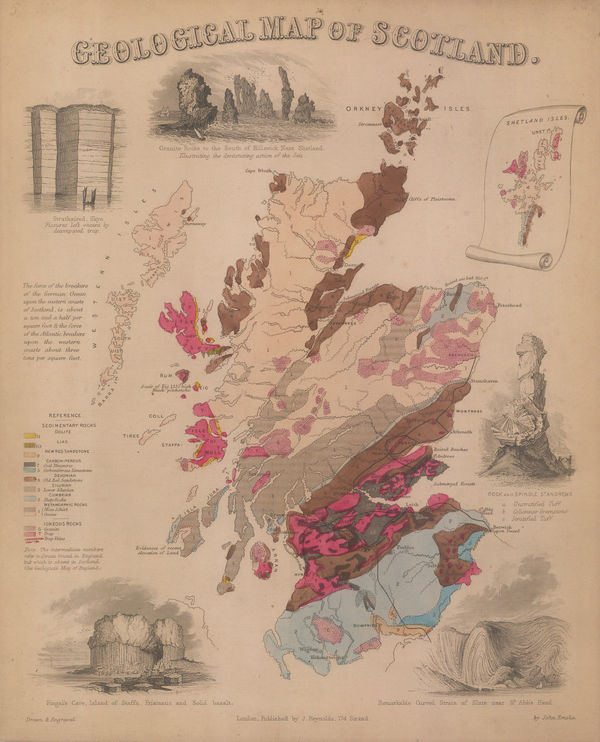
James Reynolds, Geological map of Scotland, 1850 c£ 545.00
-
Edward Hitchcock, A Geological Map of the United States and Canada, 1853£ 985.00
-
Joseph Meyer, Geological Map of the United States, 1853£ 475.00
-
Geological Map of the Mississippi River to the Pacific Ocean, 1855United States Pacific Railroad Expeditions (USPRR)Series: Washington, D.C.United States Pacific Railroad Expeditions (USPRR), Geological Map of the Mississippi River to the Pacific Ocean, 1855£ 775.00
-
Geological Section from the Mississippi River to the Pacific Ocean, 1855United States Pacific Railroad Expeditions (USPRR)Series: Washington, D.C.United States Pacific Railroad Expeditions (USPRR), Geological Section from the Mississippi River to the Pacific Ocean, 1855£ 675.00
-
Justus Perthes, Geological Map of India, 1855£ 145.00
-
W. & A.K. Johnston, Geological Map of the World, 1855£ 750.00
-
William P. Blake, Geological Map of California, 1855£ 795.00
-
W. & A.K. Johnston, Geological Map of Europe, 1856£ 3,500.00
-
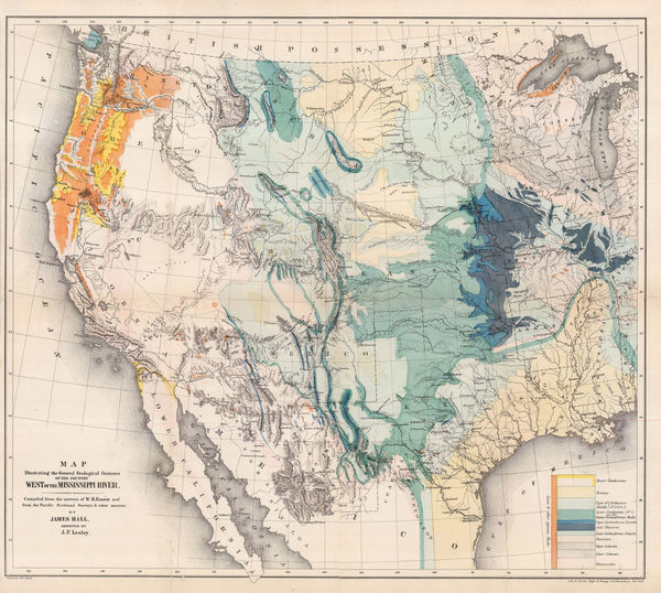
Map Illustrating the General Geological features of the Country West of the Mississippi River, 1857James HallSeries: Washington, D.C.James Hall, Map Illustrating the General Geological features of the Country West of the Mississippi River, 1857£ 1,350.00
-
Robert William Mylne, Geological and Topographical Map of London & its Environs, 1858£ 2,500.00
-
Justus Perthes, Geological Map of Austria-Hungary, 1863£ 125.00
-
Justus Perthes, Geological map of Victoria, 1865£ 195.00
-
Ordnance Survey, Geological map of Western Surrey, 1868£ 375.00
-
Bernhard Studer, Geological map of Switzerland, 1869 c.£ 1,650.00
-
Geological Map of the Lead Region in the States of Wisconsin, Illinois and Iowa, 1870 c.J.D. WhitneyJ.D. Whitney, Geological Map of the Lead Region in the States of Wisconsin, Illinois and Iowa, 1870 c.£ 585.00
-
Newton Horace Winchell, A Geological Map of The Black Hills, 1875£ 585.00
-
Jules Marcou, Geological Map of the World, 1875£ 4,250.00
-
Reginald A.F. Murray, Geological Map of Gipps Land, 1875£ 825.00
-
Justus Perthes, Coalfields of the United States, 1875£ 125.00
-
Ferdinand Moritz Krause, Ararat Gold Field, 1876£ 495.00
-
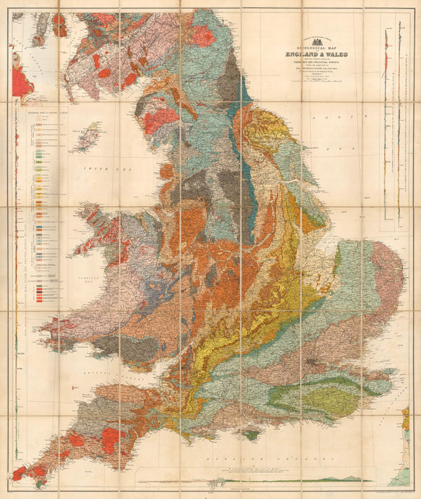
Sir Andrew Crombie Ramsay, Geological Map of England & Wales, 1876£ 725.00
-
Survey of India, Preliminary Sketch of the Geology of India, 1877£ 1,750.00
-
Edward Stanford, Geological Map of Ireland, 1878£ 1,200.00
-
James Wyld, Map of the Superficial Geology of London and its Environs, 1878 c.£ 825.00
-
Edward Stanford, Geological Map of Newfoundland, 1879£ 3,250.00
-
-
J. van Voorst, Geological Map of Surrey, 1880 c.£ 485.00
-
Justus Perthes, Geological Map of Haida Gwaii, British Columbia, 1881£ 125.00
-
Ordnance Survey, Geological Survey of England and Wales, 1882£ 120.00
-
Justus Perthes, Geological Map of West Africa, 1882£ 425.00
-
Ordnance Survey, Geological Survey of England and Wales, 1883£ 120.00
-
Reginald A.F. Murray, Geological Survey of Gipps Land, 1884£ 125.00
-
Ordnance Survey, Geological Survey of Great Britain, 1884£ 375.00
-
Justus Perthes, Geological map of Southeast Africa, 1884£ 295.00
-
Edward Stanford, The World in Hemispheres, 1885£ 245.00
-
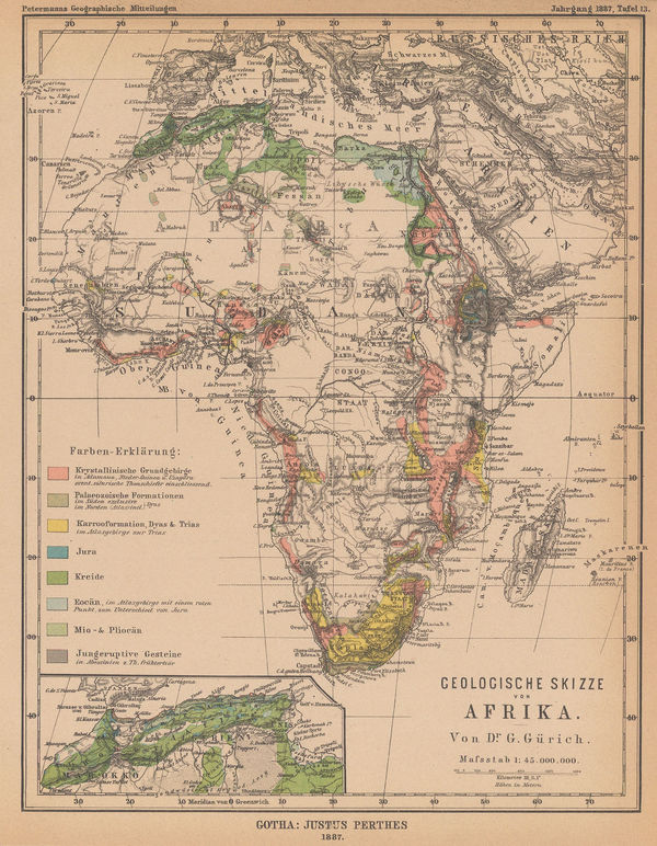
Justus Perthes, Geological sketch map of Africa, 1887£ 88.00
-
Ordnance Survey, Geological Survey of England and Wales, 1888£ 175.00
-
Ordnance Survey, Geological Survey of England and Wales, 1889£ 375.00
-
Ordnance Survey, Geological Survey of England and Wales, 1891£ 120.00
-
Ordnance Survey, Geological Survey of England and Wales, 1892£ 120.00
-
Royal Geographical Society (RGS), Geological map of Hokkaido, 1893£ 185.00
-
Ordnance Survey, Isle of Wight, 1893£ 325.00
-
Royal Geographical Society (RGS), Botswana & the Kalahari Desert, 1893£ 98.00
-
Scottish Geographical Society (SGS), Map of the Labrador Peninsula, 1895£ 325.00
-
Justus Perthes, Geological Map of Southeast Iceland, 1895£ 78.00
-
Sir Archibald Geikie, Geological Map of the British Isles, 1896£ 4,000.00
-
Sir Archibald Geikie, Geological Map of England & Wales, 1897 (c.)£ 550.00
-
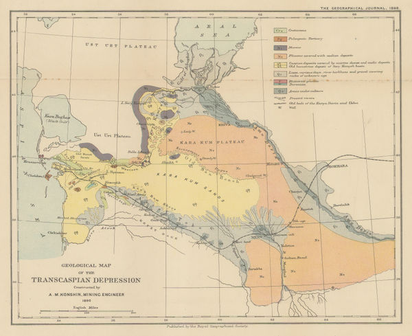
Royal Geographical Society (RGS), Geological map of the Transcaspian Depression, 1898£ 95.00
-
Edward Stanford, Stanford's Geological Map of London Shewing Superficial Deposits, 1899£ 425.00
-
John Bartholomew & Co., Geological Map of Scotland, 1900 (c.)£ 550.00
-
Dr. G.A.F Molengraff, Geological Sketchmap of the Transvaal, 1902£ 825.00
-
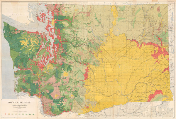
George Howard Plummer, Timber Map of Washington State, 1902£ 2,750.00
-
Geological Survey, Geological Map of London, 1904£ 725.00
-
Ordnance Survey, Geological Survey of England and Wales, 1904£ 150.00
-
Deep Sea Deposits of the South Atlantic Ocean and Weddell Sea, 1905Scottish Geographical Society (SGS)Series: EdinburghScottish Geographical Society (SGS), Deep Sea Deposits of the South Atlantic Ocean and Weddell Sea, 1905£ 950.00
-
Ordnance Survey, Geological Survey of England and Wales, 1907£ 120.00
-
Ordnance Survey, Geological Survey of England and Wales Sheet 18 & Part of 17, 1907£ 150.00
-
Ordnance Survey, Geological Map of Oxford & Environs, 1908£ 175.00
-
Edward Stanford, Geological Map of Ireland, 1912£ 55.00
-
Edward Fisher Pittman, Geological Map of New South Wales, 1914£ 1,450.00
-
James Perrin Smith, Geological Map of California, 1916£ 4,000.00
-
Royal Geographical Society (RGS), Geological Map of New Caledonia, 1917£ 285.00
-
Louis Gentil, Geological map of Morocco, 1920£ 945.00
-
Ordnance Survey, Geological Survey of England and Wales, 1920£ 150.00
-
Clason Map Co., Prospector's Guide of Colorado, 1920 c.£ 425.00
-
Kinosuke Inouye, Map of Applied Geology - Japan - Copper, 1922£ 495.00
-
Royal Geographical Society (RGS), The Geology of the Mount Everest Region, 1922£ 675.00
-
Ordnance Survey, Geological Map of the British Isles, 1924£ 885.00
-
Ordnance Survey, Geological Survey of England and Wales, 1925£ 120.00


Page
1
of 2