-
 Laurie & Whittle, Madeira & the Canary Islands, 1794£ 925.00
 -
Laurie & Whittle, A Chart of the Nicobar Islands in the Gulf of Bengal, 1794£ 750.00
-
Laurie & Whittle, Chart of the East China Sea, 1794£ 2,450.00
-
Laurie & Whittle, A Chart of the Northern Part of the Indian Ocean, 1794£ 2,850.00
-
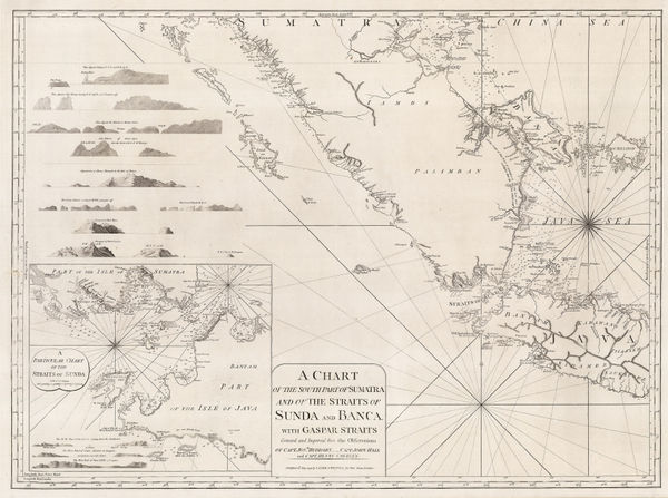
A Chart of the Southern Part of Sumatra and of the Straits of Sunda and Banca, 1794Laurie & WhittleSeries: LondonLaurie & Whittle, A Chart of the Southern Part of Sumatra and of the Straits of Sunda and Banca, 1794£ 925.00
-
Laurie & Whittle, Chart of entrance to the Hooghly River, 1794£ 1,650.00
-
Laurie & Whittle, A New Chart of the Southern Coast of Africa, 1794£ 3,250.00
-
Laurie & Whittle, Chart of the South Atlantic, 1794£ 750.00
-
Laurie & Whittle, Bali Strait, 1794£ 395.00
-
Laurie & Whittle, A Plan of Table Bay with the Road of the Cape of Good Hope, 1794£ 2,950.00
-
Laurie & Whittle, Rare chart of the Pearl River, 1794£ 4,250.00
-
Laurie & Whittle, Bay of Biscay, 1794£ 1,250.00
-
Laurie & Whittle, Sea Chart of the Devon Coast from Exmouth Bar to Stoke Point, 1794£ 650.00
-
Laurie & Whittle, Chart of the Entrance of Hudson's River, 1794£ 3,750.00
-
Laurie & Whittle, Chart of the west Coast of Sumatra, 1794£ 495.00
-
-
Laurie & Whittle, Phuket and the Mergui Archipelago, 1794£ 795.00
-
Laurie & Whittle, Chart of the Riau Islands in the Singapore Strait, 1794£ 1,250.00
-
Laurie & Whittle, Chart of Subic Bay on Luzon Island, 1794£ 825.00
-
The Coast of India and China from the Point and River of Camboja to Canton, 1794Laurie & WhittleSeries: LondonLaurie & Whittle, The Coast of India and China from the Point and River of Camboja to Canton, 1794£ 2,250.00
-
The Coast of India between Calymere and Gordeware Points including the Coast of Coromandel, 1794Laurie & WhittleSeries: LondonLaurie & Whittle, The Coast of India between Calymere and Gordeware Points including the Coast of Coromandel, 1794£ 1,250.00
-
Laurie & Whittle, The Coast of India from Point Gordeware to the Ganges, 1794£ 985.00
-
Laurie & Whittle, The Coast of India from Point Jigat to Cape Ramas, 1794£ 1,250.00
-
Laurie & Whittle, Rare chart of the Gulf of Thailand and the South China Sea, 1794£ 1,350.00
-
Charles Stedman, Revolutionary War- Battle of the Capes, 1794£ 495.00
-
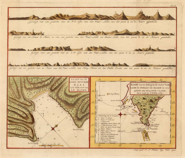
Capt. James Cook, Le Maire Straits, 1794£ 295.00
-
Charles Stedman, Plan of the siege of Yorktown in Virginia , 1794£ 2,250.00
-
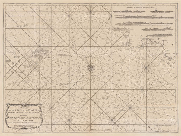
A Chart of the Chops of the Channel, to the South of Scilly Islands: Containing the West Coast of Cornwall and Scilly Islands, 1795Laurie & WhittleSeries: LondonLaurie & Whittle, A Chart of the Chops of the Channel, to the South of Scilly Islands: Containing the West Coast of Cornwall and Scilly Islands, 1795£ 545.00
-
William Heather, Caribbean Islands from the Virgin Islands to Trinidad and Tobago, 1795£ 1,950.00
-
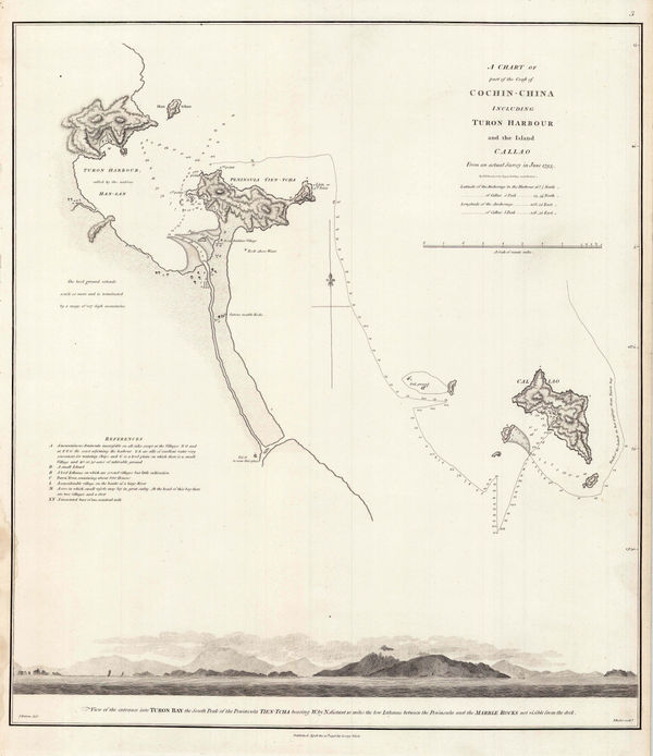
Sir George Staunton, Danang (Turon) Harbour, 1796£ 325.00
-
Sir George Staunton, Track of H.M.S. Clarence through the Zhoushan Archipelago, 1796£ 295.00
-
Sir George Staunton, Chart of the ship routes of Sir George Staunton expedition, 1796£ 725.00
-
Sir George Staunton, A General Chart on Mercator's Projection, 1796£ 1,450.00
-
Laurie & Whittle, Chart of Madagascar and Mozambique coast, 1797£ 1,250.00
-
Laurie & Whittle, Plan of the Harbour of Colombo, on the West Coast of Ceylon, 1797£ 925.00
-
Laurie & Whittle, A Hydrographic Survey of False Bay or Bay False, 1798£ 1,650.00
-
John Brydon, Battle of the Nile, 1798£ 4,950.00
-
Laurie & Whittle, Plymouth Sound, Hamoaze & Catwater, 1798£ 595.00
-
The Division of the World between the Sons of Noah after the Great Flood, 1798Robert WilkinsonSeries: LondonRobert Wilkinson, The Division of the World between the Sons of Noah after the Great Flood, 1798£ 195.00
-
Robert Wilkinson, The Trojan War, 1798£ 325.00
-
Robert Wilkinson, Ancient Persian Empire, 1798£ 175.00
-
-
William Heather, Sea Chart of the South Atlantic & South America, 1799£ 2,250.00
-
William Heather, Chart of the coast of Portugal and Spain, 1800£ 1,550.00
-
William Heather, Two charts of Islands in the Banda Sea, 1800£ 2,950.00
-
Robert Wilkinson, Roman Britain, 1800£ 165.00
-
Robert Wilkinson, Saxon England, 1800£ 185.00
-
Robert Wilkinson, Siciliae Antiquae Tabula, 1800£ 145.00
-
Robert Wilkinson, Roman Britain, 1800£ 145.00
-
William Heather, Chart of the Cape Verde Islands, 1800 c.£ 325.00
-
William Heather, Plymouth Sound, Portland and Falmouth & Helford, 1800 c.£ 950.00
-
-
William Heather, Chart of Madeira and the Canary Islands, 1801£ 1,450.00
-
William Heather, The Entrances to the River Thames, 1801£ 1,650.00
-
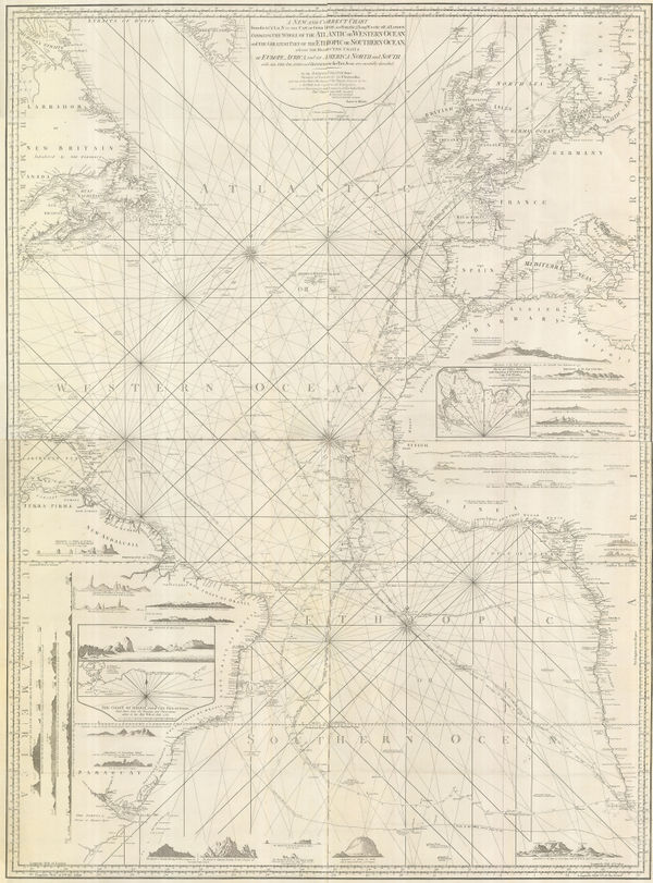
Laurie & Whittle, Extraordinary chart of the Atlantic Ocean, 1802£ 4,450.00
-
William Heather, Chart of the East Coast of England, 1802£ 950.00
-
William Heather, Bay of Biscay, 1802£ 1,950.00
-
British Admiralty, Plan of the River Saigon, 1802£ 675.00
-
William Heather, The Downs and Margate Roads, 1802£ 750.00
-
-
Robert Wilkinson, The Ancient World According to Herodotus, 1802£ 175.00
-
William Heather, Boulogne coast and environs, 1803£ 645.00
-
William Heather, Chart of the Andaman and Nicobar Islands, 1803£ 3,200.00
-
William Heather, Chart of the Azores, 1803£ 850.00
-
William Heather, Sea chart of the Bay of Bengal, 1803£ 2,250.00
-
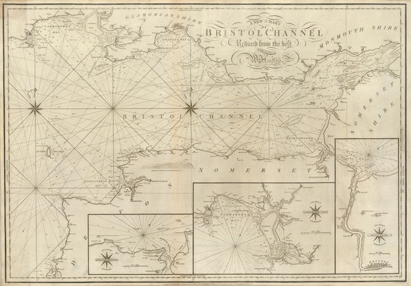
William Heather, A New Chart of the Bristol Channel, 1803£ 1,450.00
-
William Heather, Georgian chart of the Sunda Straits, 1803£ 1,950.00
-
A New Chart Shewing the Navigation through the Sunda Straights to Batavia, 1803William HeatherSeries: LondonWilliam Heather, A New Chart Shewing the Navigation through the Sunda Straights to Batavia, 1803£ 2,950.00
-
William Faden, Chart of the Baltic Sea, 1803£ 1,150.00
-
William Heather, Sea Chart of the Øresund & Copenhagen, 1803£ 1,850.00
-
Heather's New and Improved Chart of the Orkney Isles. Drawn from the Most Accurate Surveys., 1804William HeatherSeries: LondonWilliam Heather, Heather's New and Improved Chart of the Orkney Isles. Drawn from the Most Accurate Surveys., 1804£ 1,650.00
-
William Heather, Sea Chart of the British Isles, 1804£ 1,850.00
-
Robert Wilkinson, The Islamic World, 1804£ 985.00
-
-
-
Laurie & Whittle, Nelson’s Victory at the Battle of Trafalgar, 1805£ 3,500.00
-
William Faden, General Chart of the Mediterranean Sea, 1805£ 2,250.00
-
New Chart of the Coasts of England and Holland from the Latest Surveys, 1805William HeatherSeries: LondonWilliam Heather, New Chart of the Coasts of England and Holland from the Latest Surveys, 1805£ 1,750.00
-
Robert Wilkinson, Central Greece in Ancient Times, 1805£ 145.00
-
Robert Wilkinson, The Peloponnese in Ancient Times, 1805£ 175.00


Page
3
of 15