-
 Ernest Dudley Chase, The United States of America, 1935£ 1,450.00
 -
Imperial Airways, Imperial Airways - The Greatest Air Service in the World', 1935Reserved
-
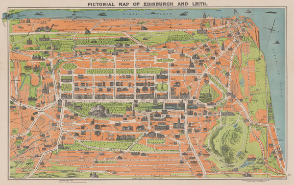
George Reid, Pictorial Map of Edinburgh and Leith, 1935£ 325.00
-
Clifford & Rosemary Ellis, Christmas Shopping by Underground Poster, 1935£ 4,000.00
-
Mississippi Coast Hotel Association, The Gulf Coast of Mississippi, 1935 (c.)£ 180.00
-
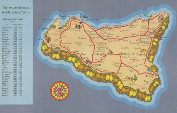
Off. Tipo-Litografiche IRES, Sicily - The Gem of the Mediterranean, 1935 (c.)£ 95.00
-
Rudolf Seeland, Berlin, 1936£ 165.00
-
Buohl's Illustrated Map and Guide to Tour The Gettysburg Battlefield, 1936George W. BuohlSeries: Gettysburg, PAGeorge W. Buohl, Buohl's Illustrated Map and Guide to Tour The Gettysburg Battlefield, 1936£ 250.00
-
Lith. Ypiranga, Rio de Janeiro, 1936£ 950.00
-
Edward Stanford, Chart of the Thames Estuary, 1936£ 345.00
-
Kingu Magazine (キング), Pre-WW2 Japanese Map of Europe, 1936£ 950.00
-
-
-
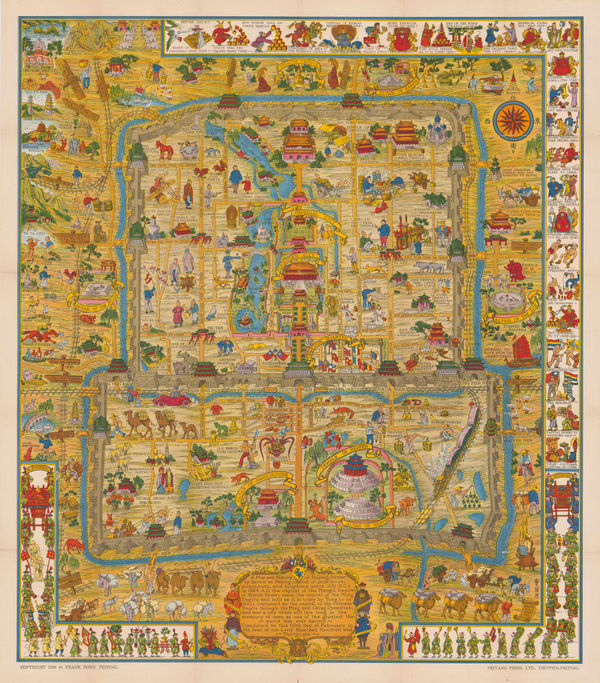
Frank Dorn, Beijing, 1936£ 2,850.00
-
Imperial Airways, Map of the Empire and European Air Routes, 1936£ 3,000 (framed)
-
-
MacDonald Gill, A Great Industry - Where Our Tea Comes From, 1937£ 4,950.00
-
British Admiralty, Arabian Sea, 1937£ 1,565.00
-
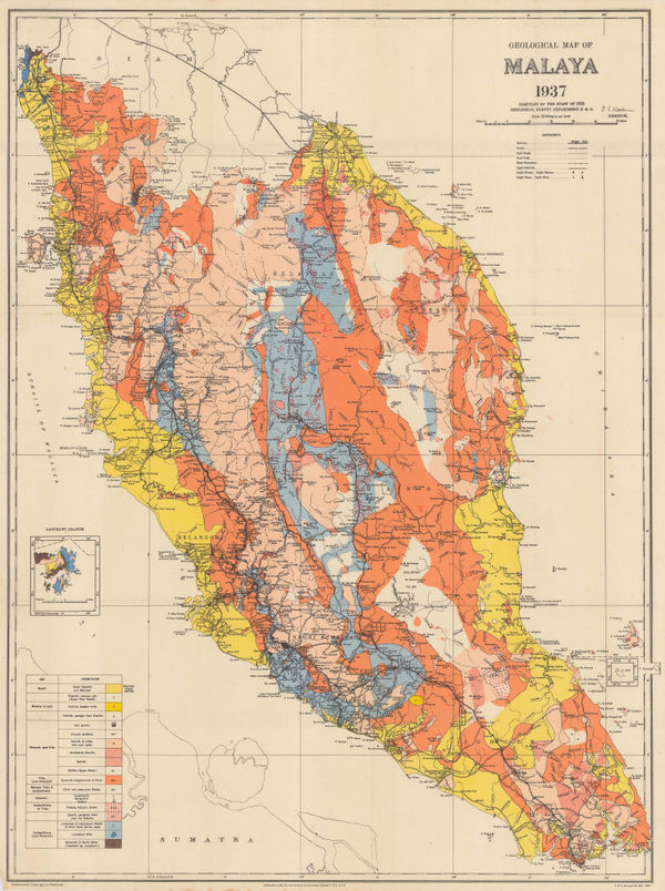
Fed. Malay States, Geological map of the Malay Peninsula, 1937£ 695.00
-
French State Railway, Paris Welcomes You, 1937£ 2,000.00
-
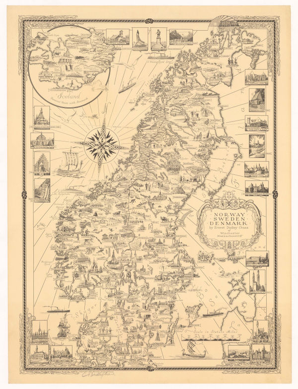
Ernest Dudley Chase, Norway, Sweden, and Denmark, 1937£ 1,250.00
-
J. Loeb, Spanish Civil War News Map, 1937£ 950.00
-
London Transport, Underground Railway Map, 1937£ 450.00
-
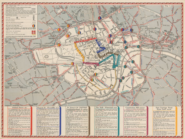
Geographia Ltd., The Coronation Area, 1937£ 450 (framed)
-
-
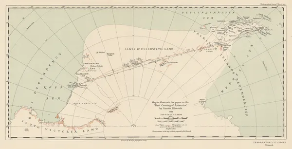
Royal Geographical Society (RGS), The "First Crossing of Antarctica", 1937£ 650.00
-
Air France, Air France 'Reseau Aerien Mondial', 1937 c.£ 4,500.00
-
Ernest Dudley Chase, Boston (Massachusetts) and Vicinity, 1938£ 950.00
-
J.G. Bartholomew, Environs of Paris: Rail and Automobile Routes, 1938£ 28.00
-
Ernest Dudley Chase, Europe - A Pictorial Map, 1938£ 1,450.00
-
James Imray, Needles Channel to Start Point, 1938£ 525.00
-
-
John Groth, WW2 Pictorial map of South America, 1938£ 950.00
-
Wolodymyr Kubijowytsch, Ethnographic Map of Ukraine, 1938£ 1,500.00
-
Stuart F. Ball, Pictorial Map of Cincinnati, 1938£ 345.00
-
Flying Magazine, The Empire Air Mail Scheme, 1938 c.£ 265.00
-
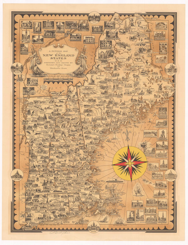
Ernest Dudley Chase, A Pictorial Map of the New England States, 1939£ 1,250.00
-
Service géographique de l'Indochine, Vintage archaeological map of the Angkor region, Cambodia, 1939£ 3,250.00
-
Hagstrom Co. Inc., New York and Routes to the New York World's Fair, 1939£ 325.00
-
Ernest Dudley Chase, Pictorial Map of Manhattan, 1939£ 1,800.00
-
Swiss Federal Railways, Switzerland, 1939£ 2,200.00
-
London Underground, Bakerloo Line Extension, 1939£ 225.00
-
Anonymous, WW2 Map of Europe, 1939£ 750.00
-
Giovanni De Agostini, Piedmont (Piemonte), 1939£ 395.00
-
J.G. Bartholomew, The Western Front at the Outbreak of WW2, 1939£ 175.00
-
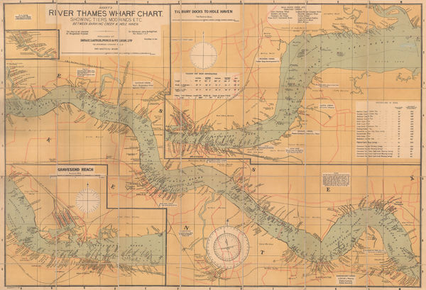
Imray & Co., River Thames Wharf Chart from Barking Creek to Hole Haven, 1939 c.£ 295.00
-
Anonymous, Nazi War Aims: Grab! Grab! GRAB!!!, 1939 c.£ 850.00
-
Mitt Schenkofsky, Merry-maker's Map of San Francisco, 1940£ 2,950.00
-
Ruth Taylor, Wine Map of California, 1940 c.£ 1,800.00
-
British Admiralty, Chart of the Windward Islands from Guadeloupe to Trinidad, 1941£ 445.00
-
Giovanni De Agostini, Lucania, 1941£ 325.00
-
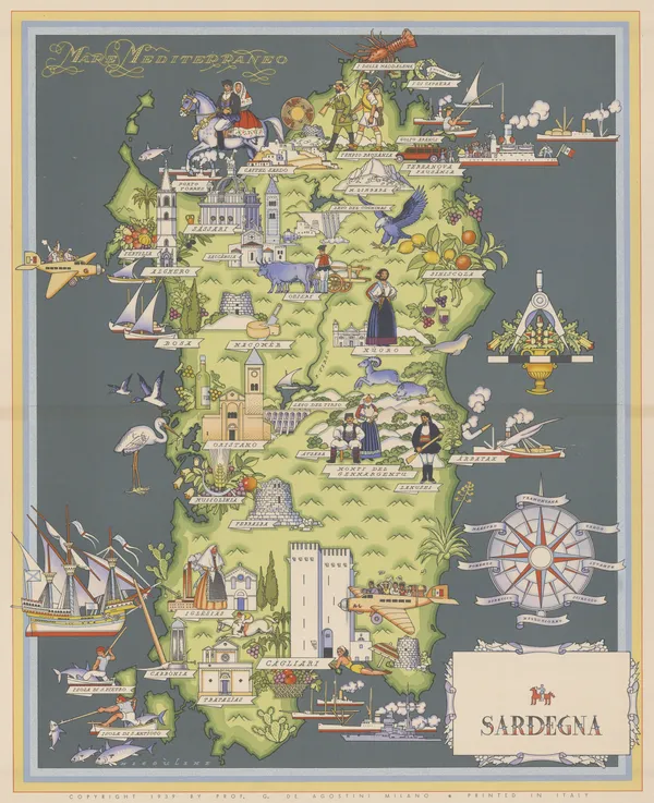
Giovanni De Agostini, Sardinia, 1941£ 525.00
-
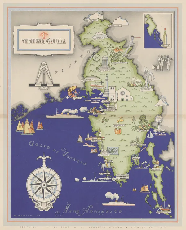
Giovanni De Agostini, Venezia Giulia, 1941£ 395.00
-
Giovanni De Agostini, Lazio, 1941£ 495.00
-
Giovanni De Agostini, Marche e San Marino, 1941£ 350.00
-
Giovanni De Agostini, Sicily, 1941£ 495.00
-
Giovanni De Agostini, Puglia, 1941£ 445.00
-
Giovanni De Agostini, Liguria, 1941£ 395.00
-
Giovanni De Agostini, Veneto, 1941£ 425.00
-
Giovanni De Agostini, Venezia Tridentina, 1941£ 325.00
-
Giovanni De Agostini, Lombardy, 1941£ 395.00
-
Giovanni De Agostini, Emilia Romagna, 1941£ 395.00
-
Giovanni De Agostini, Campania, 1941£ 425.00
-
Giovanni De Agostini, Abruzzo , 1941£ 395.00
-
André Deran, WWII - Vichy French Propaganda, 1941£ 2,500.00
-
Arthur B. Suchy, Cayo Hueso - Key West, Florida, 1941 c.£ 425.00
-
Luftwaffe, WW2-era map of Minsk, 1941 c.£ 595.00
-
S.P.K., WWII, 1941 c.£ 850.00
-
WWII commemorative map of northern Ethiopia, 1942East African Survey Group, British ArmySeries: East AfricaEast African Survey Group, British Army, WWII commemorative map of northern Ethiopia, 1942£ 495.00
-
British Admiralty, Cape San Blas to Vermilion Bay, 1942£ 750.00
-
-
S.P.K., Vichy French Churchill Octopus Map, 1942£ 2,500.00
-
British Admiralty, North America East Coast - Delaware Bay to Florida Strait, 1942£ 950.00
-
Richard Edes Harrison, One World One War, 1942£ 1,800.00
-
Plans on the Northeast Coast of Bahrein Island, 1942United States Hydrographic OfficeSeries: Washington, D.C.United States Hydrographic Office, Plans on the Northeast Coast of Bahrein Island, 1942£ 3,950.00
-
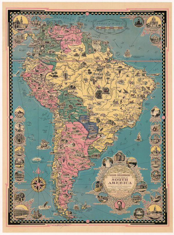
Ernest Dudley Chase, The Good Neighbor Pictorial Map of South America, 1942£ 750.00
-
-
Wings Over the World... Yesterday, Today and Tomorrow - Aviation Cavalcade, 1942F.E. CheesemanSeries: MilwaukeeF.E. Cheeseman, Wings Over the World... Yesterday, Today and Tomorrow - Aviation Cavalcade, 1942£ 750.00
-
Geographical Section, General Staff (GSGS), WW2 Map of the East Indies, 1942£ 450.00
-
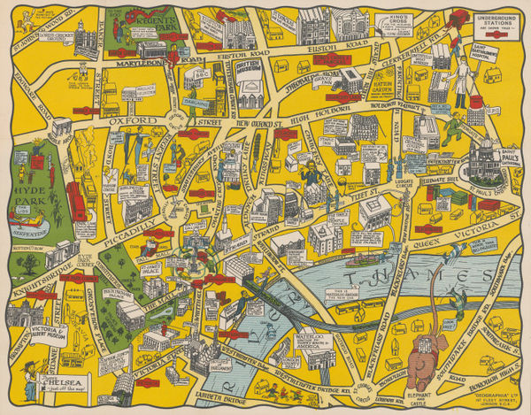
George Philip & Son Ltd., The New Pictorial Map of London, 1942 c£ 295.00


Page
11
of 15