-
 British Admiralty, Mediterranean France - South Coast - Approaches to Toulon, 1927£ 225.00
 -
British Admiralty, Chart of Sardinia on two sheets, 1927£ 1,250.00
-
British Admiralty, Chart of the Port and Harbour of Toulon, 1927£ 295.00
-
Frederic M. Thrasher, Chicago's Gangland, 1927 c.£ 2,950.00
-
Edward Stanford, Dorsetshire, Somersetshire and South Wiltshire, 1928£ 56.00
-
Edward Stanford, Hampshire, 1928£ 52.00
-
Edward Stanford, Herefordshire and Monmouthshire, 1928£ 28.00
-
Edward Stanford, Lincolnshire, 1928£ 36.00
-
Edward Stanford, Norfolk, 1928£ 42.00
-
Edward Stanford, Northumberland, 1928£ 28.00
-
Edward Stanford, Suffolk, 1928£ 42.00
-
British Admiralty, The Channel Islands and Adjacent Coasts of France, 1928£ 675.00
-
Arthur B. Suchy, The Heart of Cleveland Ohio, 1928£ 495.00
-
Railway Clearing House, Cardiff, 1928£ 55.00
-
E.G. Perman, Underground Railways of London, 1928£ 1,250.00
-
Rand, McNally & Co., A Pictorial Chart of English Literature, 1929£ 1,450.00
-
James Daugherty, This World of Ours, 1929 c.£ 2,500.00
-
Anton van der Valk, Humorous pictorial map of Dutch history, 1930£ 295.00
-
French Admiralty, French chart of Guernsey, Herm and Sark, 1930£ 675.00
-
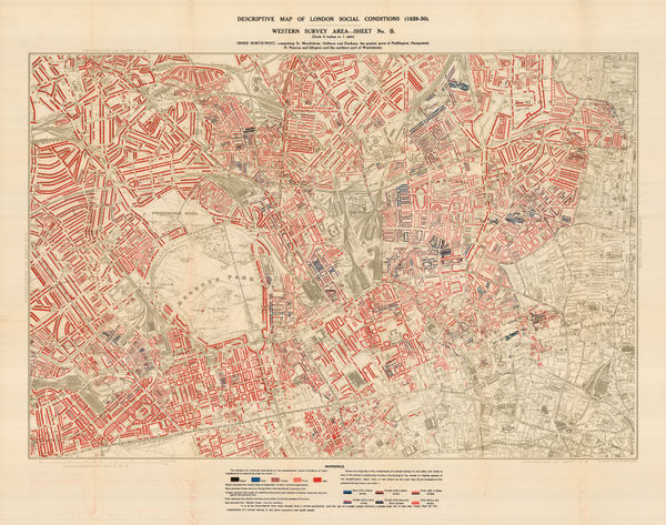
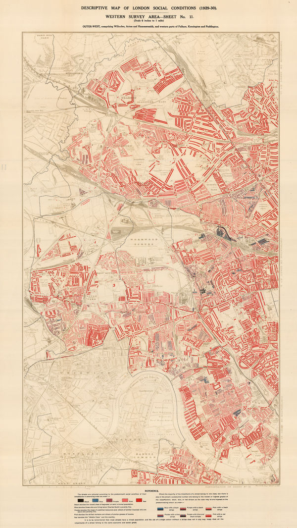
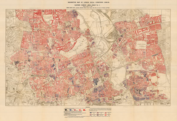
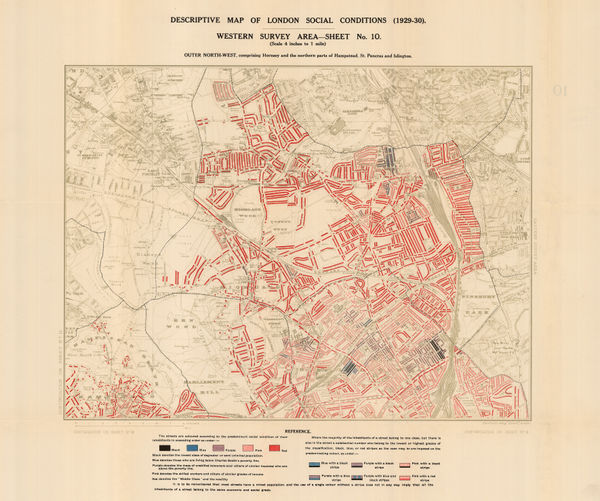
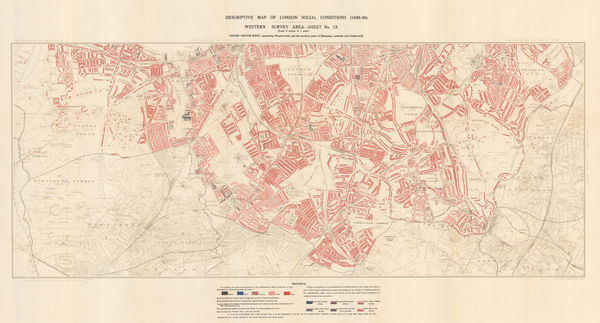
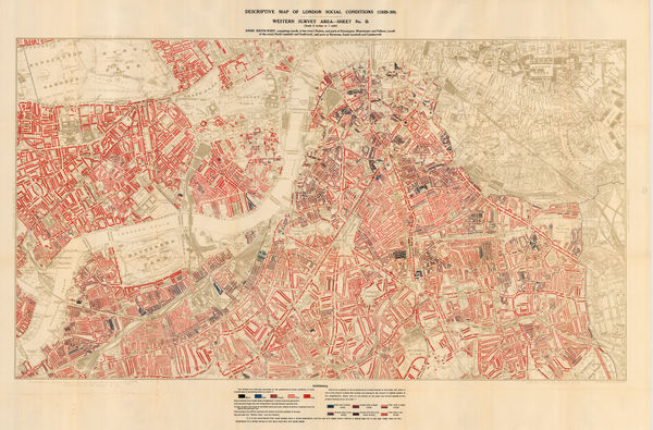
Charles Booth, Descriptive Map of London Social Conditions (1929-1930), 1930£ 1,950.00
-
Charles Booth, Descriptive Map of London Social Conditions (1929-1930), 1930£ 1,550.00
-
Charles Booth, Poverty Map of Whitechapel, Hackney, Shoreditch & Stratford, 1930£ 1,350.00
-
Charles Booth, Descriptive Map of London Social Conditions (1929-1930), 1930£ 950.00
-
Charles Booth, Poverty Map of Wandsworth, Streatham, Tooting, Clapham & Dulwich, 1930£ 1,450.00
-
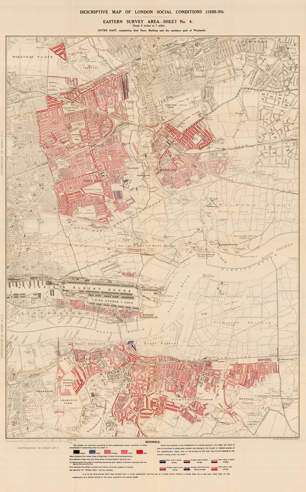
Charles Booth, Poverty Map of Royal Docks, Barking & Woolwich, 1930£ 650.00
-
Charles Booth, Descriptive Map of London Social Conditions (1929-1930), 1930£ 2,500.00
-
Royal Geographical Society (RGS), Great Barrier Reef - Low Isles, 1930£ 385.00
-
British Admiralty, The Brothers to Ockseu Is., 1930£ 1,750.00
-
Royal Geographical Society (RGS), Three Isles (Great Barrier Reef), 1930£ 385.00
-
Jean Dollfus, Rhone Valley, 1930£ 950.00
-
Fred H. Stingemore, Map of London's Underground Railways, 1930£ 795.00
-
-
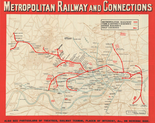
London Underground, Metropolitan Railway and Connections, 1930 (c.)£ 550.00
-
Jean Dollfus, Burgundy Nievres, 1930 c.£ 950.00
-
John Kirk Sewall, Pictorial map of Beijing, 1930 c.£ 3,500.00
-
Intourist, Pictorial Map of the Caucasus, 1930 c.£ 1,750.00
-
Alexander Nicohosoff, Tourist Map of Cairo, 1930 c.£ 145.00
-
McCorquodale & Co., Gilbey's Rubicon Burgundy, 1930 c.£ 200.00
-
Turzak & Chapman, Chicago USA, 1931£ 2,500.00
-
-
-
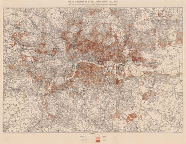
Charles Booth, Map of Overcrowding in the London Survey Area (1931), 1931£ 1,950.00
-
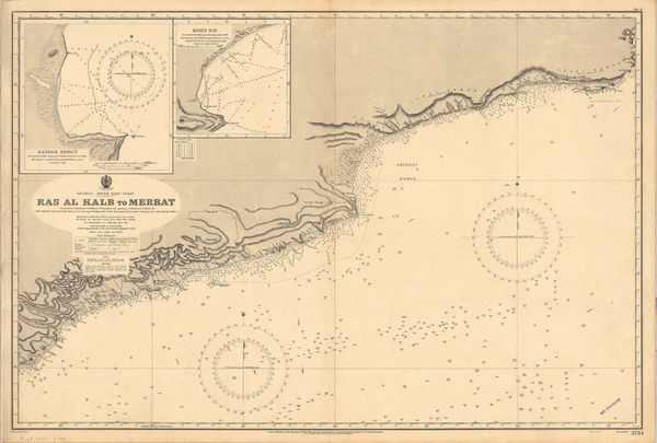
British Admiralty, Merbat to Masira Island., 1931£ 1,550.00
-
British Admiralty, Chart of the South Arabian coast, 1931£ 1,550.00
-
Fred H. Stingemore, Map of London's Underground Railways, 1931£ 795.00
-
British Admiralty, Bassein River to Pulo Penang, 1932£ 1,550.00
-
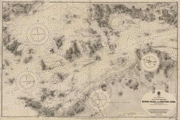
British Admiralty, Channels between Bingo Naga and Ozuchi Jima., 1932£ 495.00
-
British Admiralty, Gulf of Siam, 1932£ 2,850.00
-
-
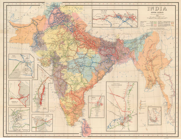
Survey of India, India Showing Railways, 1932£ 475.00
-
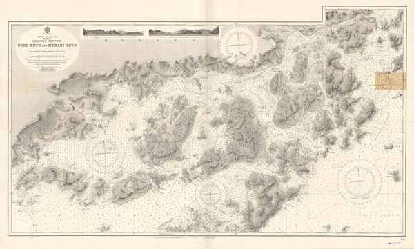
British Admiralty, Japan Inland Sea. Channels between Neko Seto & Mekari Seto, 1932£ 625.00
-
British Admiralty, Kiaochow Bay, 1932£ 1,850.00
-
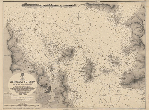
British Admiralty, Kurusima No Seto (Kaikyo), 1932£ 295.00
-
André Galland, French Anti-Disarmament Propaganda, 1932£ 1,800.00
-
Intourist, Pictorial map of St. Petersburg (Leningrad), 1932£ 145.00
-
Edward Stanford, Hyde Park Corner Tube Station and 1/4 Miles Around, 1932£ 1,250.00
-
British Admiralty, Ockseu Is. to Tung Yung, 1932£ 885.00
-
British Admiralty, Southern Approach to the Yangtze Kiang, 1932£ 1,450.00
-
British Admiralty, Tien Pak to Macao, 1932£ 1,550.00
-
British Admiralty, Tung Yung to Wen Chau Bay, 1932£ 885.00
-
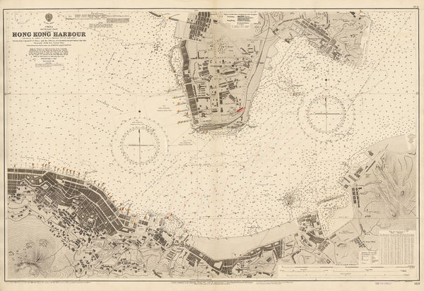
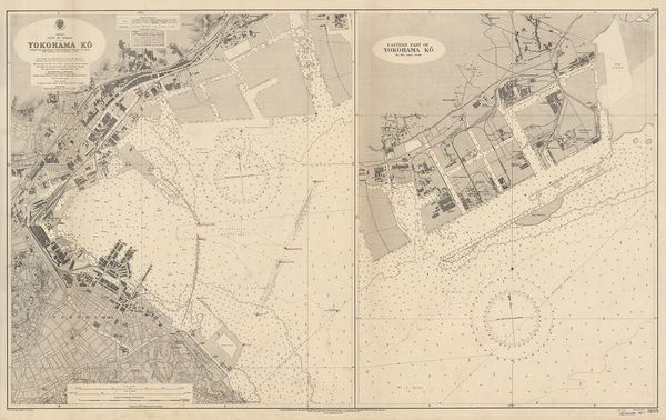
British Admiralty, YokoHama-Ko, 1932£ 725.00
-
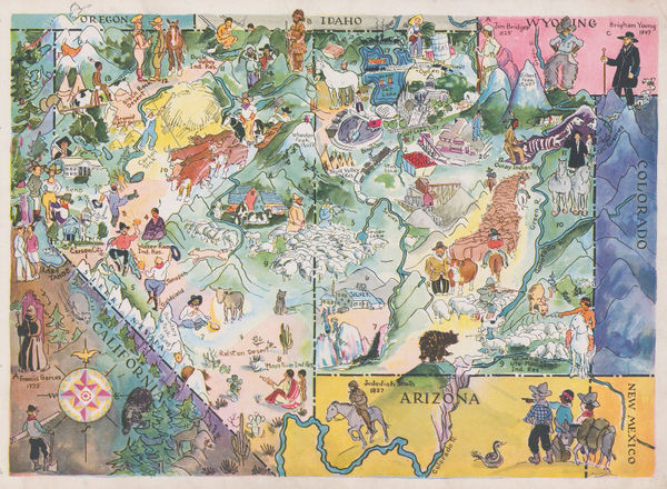
Elmer & Berta Hader, Colorado and Wyoming, 1932£ 95.00
-
Elmer & Berta Hader, Nevada and Utah, 1932£ 85.00
-
Elmer & Berta Hader, Kansas and Nebraska, 1932£ 85.00
-
Elmer & Berta Hader, Kentucky and Tennessee, 1932£ 95.00
-
London Transport, London Tramways, 1932£ 150.00
-
-
Harry Beck, September/October Edition, 1933£ 1,450.00
-
British Admiralty, Bingo Nada and Ozuchi Jima, 1934£ 495.00
-
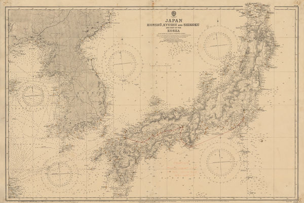
British Admiralty, Japan, Honshu, Kyushu & Shikoku and part of the Korea, 1934£ 895.00
-
British Admiralty, Malta and Gozo Islands, 1934£ 1,750.00
-
Luis de la Pena, Geological map of Spain and Portugal, 1934£ 325.00
-
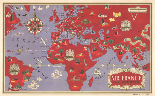
Air France, Air France - 'Reseau Aerien Mondial', 1934£ 3,500.00
-
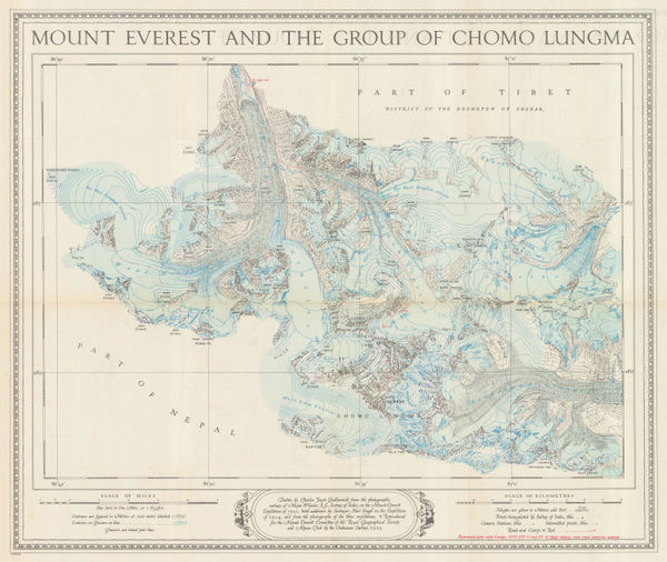
Ordnance Survey, Mount Everest and the Group of Chomo Lungma, 1934£ 1,500.00
-
Harry Beck, No. 1, 1934£ 750.00
-
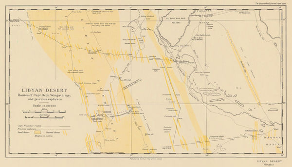
Royal Geographical Society (RGS), Orde Wingate's Egypt Expedition, 1934£ 175.00
-
Ernest Dudley Chase, A Pictorial Map of the British Isles, 1935£ 950.00
-
Walter Riemer, Romanian Map of Germany for the 1936 Berlin Olympics, 1935£ 750.00
-
A. de Boeck, Brussels (Bruxelles), 1935£ 350.00
-
Ernest Dudley Chase, The United States of America, 1935£ 1,450.00


Page
10
of 15