-
 Claudius Ptolemy & Laurent Fries, Ptolemaic Map of France, 1541£ 1,750.00
 -
-
Abraham Ortelius, Ancient Belgium, 1592£ 945.00
-
Abraham Ortelius, Ancient Germany, 1592£ 495.00
-
Samuel Purchas, Holy Land during Biblical times, 1625£ 395.00
-
John Speed, The Ancient Roman Empire , 1627£ 3,950.00
-
Benito Arias Montanus, Ancient Jerusalem, 1640 c.£ 575.00
-
Jan Jansson, Thrace during the Classical period, 1640 c.£ 625.00
-
Jan Jansson, Ancient Crete, 1661£ 245.00
-
Jan Jansson, Ancient Greece, 1661£ 325.00
-
Jan Jansson, Northern Italy, or Cisalpine Gaul, 1661£ 195.00
-
Jan Jansson, Ancient Thrace, 1661£ 175.00
-
Jan Jansson, Tuscany during the Roman Period, 1661£ 285.00
-
John Speed, Anglo-Saxon Britain, 1676£ 4,750.00
-
Vincenzo Coronelli, Ancient World, 1692 c£ 950.00
-
Nicolas Sanson, The Middle East and Mediterranean illustrating Biblical Geography, 1700£ 595.00
-
Herman Moll, Historical Map of the Roman Empire, 1730 c£ 2,450.00
-
Robert de Vaugondy, The Ancient World, 1752£ 2,750.00
-
Robert Sayer, Ancient Egypt, 1780 c.£ 195.00
-
Battlefields. A Graphical Guide to the Places described in the History of England, 1790 c.J.M. WauthierSeries: LondonJ.M. Wauthier, Battlefields. A Graphical Guide to the Places described in the History of England, 1790 c.£ 495.00
-
Robert Wilkinson, Terra Veteribus Nota, 1796£ 145.00
-
The Division of the World between the Sons of Noah after the Great Flood, 1798Robert WilkinsonSeries: LondonRobert Wilkinson, The Division of the World between the Sons of Noah after the Great Flood, 1798£ 195.00
-
Robert Wilkinson, Roman Empire, 1798£ 245.00
-
Robert Wilkinson, The Trojan War, 1798£ 325.00
-
Robert Wilkinson, Ancient Persian Empire, 1798£ 175.00
-
Robert Wilkinson, Ancient Empires, 1800£ 95.00
-
Robert Wilkinson, Roman Britain, 1800£ 165.00
-
Robert Wilkinson, Saxon England, 1800£ 185.00
-
Robert Wilkinson, Siciliae Antiquae Tabula, 1800£ 145.00
-
Robert Wilkinson, Roman Britain, 1800£ 145.00
-
Robert Wilkinson, The Ancient World According to Herodotus, 1802£ 175.00
-
Robert Wilkinson, The Islamic World, 1804£ 985.00
-
Robert Wilkinson, Central Greece in Ancient Times, 1805£ 145.00
-
Robert Wilkinson, The Empire of Alexander the Great, 1807£ 145.00
-
C.V. Lavoisne, Geographical and Historical Map of Greece, 1813£ 245.00
-
Thomas Kitchin, The Roman Empire (East & West), 1815£ 550.00
-
Richard Holmes Laurie, Ancient Greece, 1820£ 625.00
-
J. Vincent, Ancient Scythia , 1828£ 64.00
-
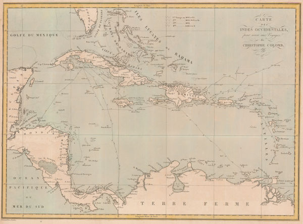
Pierre Tardieu, The Voyages of Christopher Columbus, 1828£ 950.00
-
Edward Quin, A.D. 1100. Period of the First Crusade, 1830 c.£ 245.00
-
Edward Quin, A.D. 1294. The Empire of Kublai Khan, 1830 c.£ 545.00
-
Edward Quin, A.D. 1551. At the Death of Charles V., 1830 c.£ 495.00
-
Edward Quin, A.D. 1660. At the Restoration of the Stuarts, 1830 c.£ 495.00
-
Edward Quin, A.D. 395. The Division of the Roman Empire, 1836£ 225.00
-
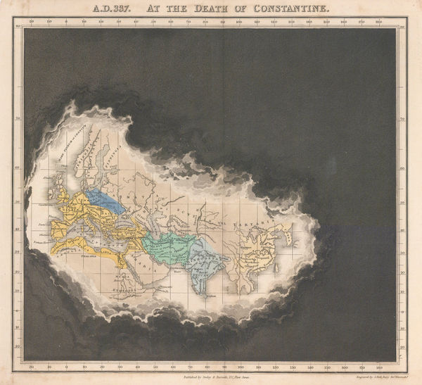
Edward Quin, A.D. 337 At the Death of Constantine, 1836£ 295.00
-
Edward Quin, B.C. 753 The Foundation of Rome , 1836£ 115.00
-
Edward Quin, B.C. 301. Exhibiting the Partition of the Empire of Alexander, 1836£ 95.00
-
Royal Geographical Society (RGS), Ancient settlements of Minoa and Nisea, 1837£ 58.00
-
Royal Geographical Society (RGS), Sketch map of the Iran and Iraq border, 1839£ 145.00
-
Sketch of the Acquisitions of Russia since the Accession of Peter 1st to the Throne, 1842John ArrowsmithSeries: LondonJohn Arrowsmith, Sketch of the Acquisitions of Russia since the Accession of Peter 1st to the Throne, 1842£ 495.00
-
Topographical Survey of the Plain of Troy with the Ancient Sites, 1842Royal Geographical Society (RGS)Series: LondonRoyal Geographical Society (RGS), Topographical Survey of the Plain of Troy with the Ancient Sites, 1842£ 380.00
-
Robert Wilkinson, Six Chrono-Genealogical Charts of Biblical History, 1842£ 240
-
Robert Wilkinson, The Heart of the Roman Empire, 1842£ 125.00
-
Robert Wilkinson, The Empire of Charlemagne, 1842£ 95.00
-
Robert Wilkinson, Ancient Anatolia, 1842£ 85.00
-
Robert Wilkinson, Syria and Assyria, 1842£ 85.00
-
Robert Wilkinson, The March of the Ten Thousand Greeks, 1842£ 135.00
-
Robert Wilkinson, King Solomon's Twelve Purveyors, 1842£ 85.00
-
Robert Wilkinson, Parthian Empire, 1842£ 125.00
-
Robert Wilkinson, Canaan from the Time of Joshua to the Babylonish Captivity, 1842£ 195.00
-
Robert Wilkinson, The Route of St. Paul, 1842£ 125.00
-
Society for the Diffusion of Useful Knowledge (SDUK), Ancient Britain, 1843£ 95.00
-
Society for the Diffusion of Useful Knowledge (SDUK), Ancient Rome, 1844£ 325.00
-
Royal Geographical Society (RGS), Ruins of Ancient Milos, 1852£ 88.00
-
Edward Quin, A.D. 1660. At the Restoration of the Stuarts, 1856£ 385.00
-
Edward Quin, A.D. 476. The Dissolution of the Western Empire, 1856 c.£ 125.00
-
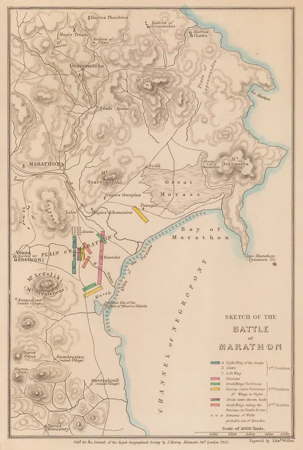
Royal Geographical Society (RGS), Sketch of the Battle of Marathon, 1857£ 88.00
-
J. & C. Walker, The Early Caliphates, 1862£ 275.00
-
Edward Quin, A.D. 1783. Independence of the United States, 1865 c.£ 495.00
-
Society for the Diffusion of Useful Knowledge (SDUK), Ancient Egypt, 1879£ 145.00
-
Emil Reich, Campaigns in India, 1903£ 55.00
-
Emil Reich, India in 1804, 1903£ 65.00
-
Emil Reich, Anglo-Mysore Wars, 1903£ 58.00
-
Emil Reich, Campaigns in India 1802-1852, 1903£ 62.00
-
Emil Reich, Battle of Marston Moor and Battle of Naseby, 1903£ 55.00
-
Emil Reich, Spanish Peninsular War, 1903£ 60.00
-
Emil Reich, The British Empire about 1800, 1903£ 70.00
-
Emil Reich, English Voyages of Discovery during the Tudor Period, 1903£ 68.00
-
Emil Reich, Roman Britain, 1903£ 58.00
-
Emil Reich, Wars of the Roses, 1903£ 55.00


Page
1
of 2