-

-
-
Vincenzo Coronelli, Third printed map of Australia, 1692£ 3,450.00
-
-
-
Jacques-Nicolas Bellin, Important and early map of Australia, 1758 c.£ 2,550.00
-
Capt. James Cook, Endeavour Strait to Cape Tribulation, Queensland, 1773£ 750.00
-
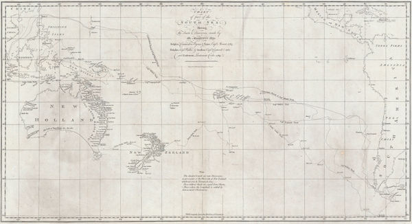
Capt. James Cook, Cook's Discoveries in Australia, New Zealand & the Pacific, 1773£ 1,750.00
-
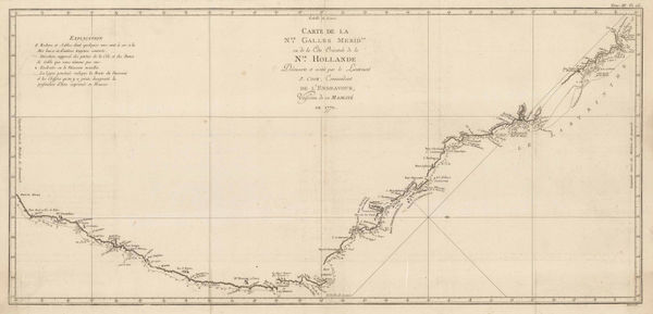
Capt. James Cook, James Cook's Map of New South Wales & Queensland, 1774£ 1,250.00
-
Capt. James Cook, Botany Bay and the mouth of the Endeavour River, 1784£ 245.00
-
John Stockdale, Plan of Port Jackson, New South Wales, 1789£ 1,250.00
-
Franz Anton Schraembl, Rare, very early map of Port Jackson and environs, 1795£ 825.00
-
-
Louis-Claude de Freycinet, Joseph Bonaparte Gulf, 1811£ 650.00
-
Louis-Claude de Freycinet, 80 Mile Beach, Western Australia , 1811£ 550.00
-
Louis-Claude de Freycinet, Bonaparte Archipelago, Western Australia, 1811£ 550.00
-
Louis-Claude de Freycinet, North-west coast from Exmouth Gulf to Darwin, 1811£ 950.00
-
Louis-Claude de Freycinet, Chart of Tasmania, 1811£ 1,550.00
-
-
Louis-Claude de Freycinet, Port Jackson and Sydney Harbour, 1811£ 4,950.00
-
Aaron Arrowsmith & Samuel Lewis, Australasia, 1812£ 375.00
-
-
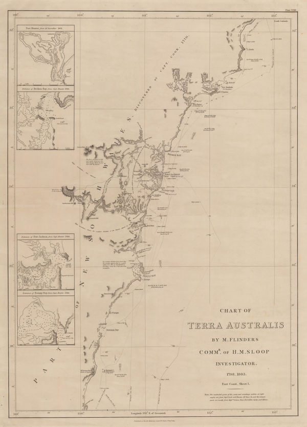
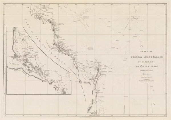
Matthew Flinders, Sea Chart from Brisbane to Port Macquarie, 1814£ 3,500.00
-
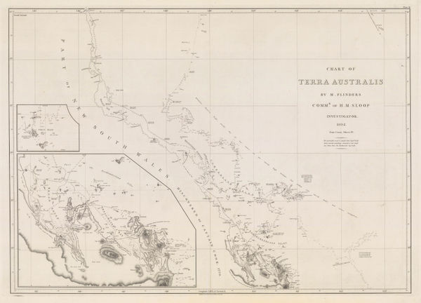
The Coast of Queensland from the Sunshine Coast to Shoalwater Bay, 1814Matthew FlindersSeries: LondonMatthew Flinders, The Coast of Queensland from the Sunshine Coast to Shoalwater Bay, 1814£ 4,500.00
-
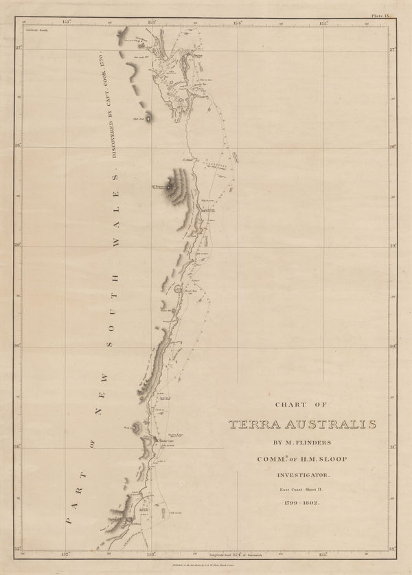
Matthew Flinders, The Coast of Queensland from Shoalwater Bay to Cairns, 1814£ 4,500.00
-
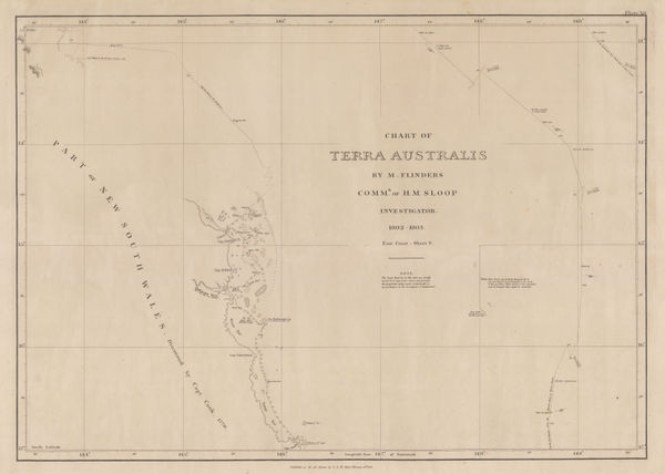
Matthew Flinders, The Coast of Queensland from Cairns to Cape Flattery, 1814£ 3,000.00
-
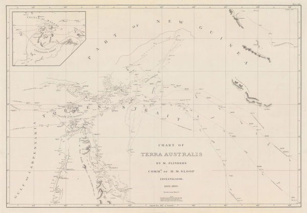
Matthew Flinders, Sea Chart of the Torres Strait, 1814£ 3,500.00
-
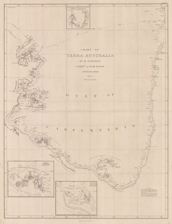
Matthew Flinders, The Gulf of Carpentaria, 1814£ 4,000.00
-
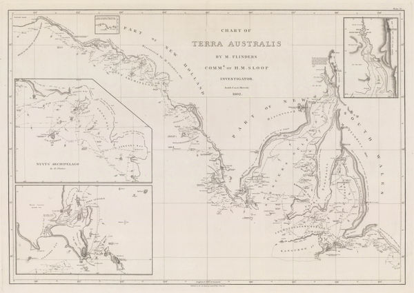
Matthew Flinders, South coast of Western Australia from Cape Leeuwin to Cape Arid, 1814£ 3,500.00
-
-
-
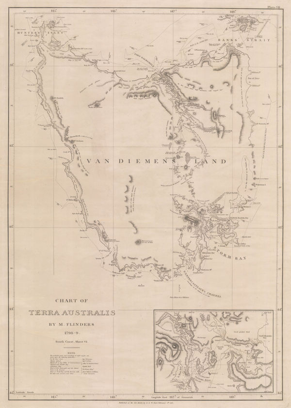
Matthew Flinders, Chart of Tasmania, 1814£ 4,500.00
-
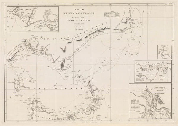
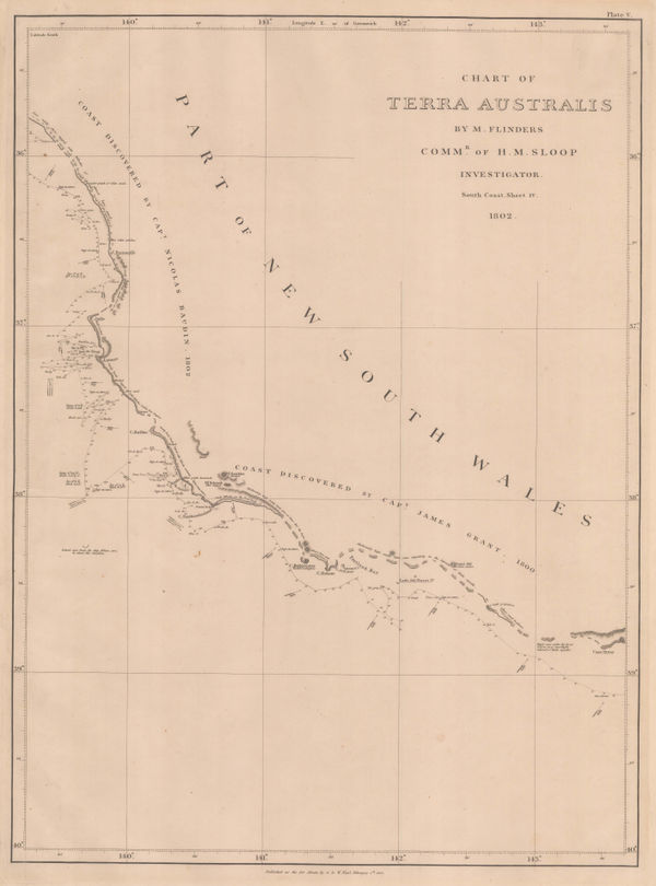
Matthew Flinders, Southern Australian coast from Melbourne to Adelaide, 1814£ 2,500.00
-
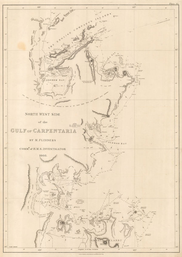
Matthew Flinders, Gulf of Carpentaria, northwest shore, 1814£ 2,000.00
-
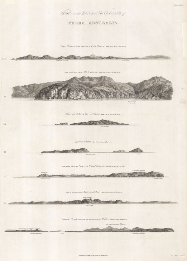
Matthew Flinders, Views of Queensland and the Torres Strait coast, 1814£ 750.00
-
Southern coast of Tasmania from Macquarie Harbour to Freycinet peninsula., 1827Philippe VandermaelenSeries: BrusselsPhilippe Vandermaelen, Southern coast of Tasmania from Macquarie Harbour to Freycinet peninsula., 1827£ 295.00
-
Western Australia coast from North west Cape to Roebuck Bay, 1827Philippe VandermaelenSeries: BrusselsPhilippe Vandermaelen, Western Australia coast from North west Cape to Roebuck Bay, 1827£ 495.00
-
Philippe Vandermaelen, The Great Barrier Reef & Queensland Coast, 1827£ 1,450.00
-
Western Australia coast from Mount Peron to Esperance Bay, 1827Philippe VandermaelenSeries: BrusselsPhilippe Vandermaelen, Western Australia coast from Mount Peron to Esperance Bay, 1827£ 625.00
-
Philippe Vandermaelen, Melville Island and Timor Sea, 1827£ 295.00
-
Philippe Vandermaelen, Western Australia coast east of Recherche Archipelago, 1827£ 445.00
-
Philippe Vandermaelen, South Australia & Adelaide, 1827£ 645.00
-
Western Australian coast from Cape Cuvier to Moresby Range, 1827Philippe VandermaelenSeries: BrusselsPhilippe Vandermaelen, Western Australian coast from Cape Cuvier to Moresby Range, 1827£ 445.00
-
Philippe Vandermaelen, North Western coast from Cape Boileau to Cambridge Gulf, 1827£ 345.00
-
Philippe Vandermaelen, Australia - Northern Territory inc. Darwin, 1827£ 425.00
-
Philippe Vandermaelen, The Gulf of Carpentaria, 1827£ 395.00
-
Philippe Vandermaelen, Southern coast from Long Bay to Cape Otway, 1827£ 335.00
-
Philippe Vandermaelen, The colony of New South Wales, 1827£ 985.00
-
Philippe Vandermaelen, Coast of Queensland from Cape Melville to Cairns, 1827£ 425.00
-
Bass Strait, southern New South Wales and northern Tasmania, 1827Philippe VandermaelenSeries: BrusselsPhilippe Vandermaelen, Bass Strait, southern New South Wales and northern Tasmania, 1827£ 595.00
-
Justus Perthes, New South Wales, 1828£ 395.00
-
Baron Hyacinthe de Bougainville, Important plan of Port Jackson, 1828£ 3,450.00
-
John Thomson, New South Wales and Tasmania, 1828£ 1,250.00
-
Selina Hall, Australia, 1830 c.£ 525.00
-
Royal Geographical Society (RGS), New South Wales and South Eastern Australia, 1832£ 795.00
-
Royal Geographical Society (RGS), Southwest Australia from Perth to Albany, 1832£ 1,350.00
-
Western Australia and Tasmania, 1833Society for the Diffusion of Useful Knowledge (SDUK)Series: LondonSociety for the Diffusion of Useful Knowledge (SDUK), Western Australia and Tasmania, 1833£ 135.00
-
Justus Perthes, Southeastern Australia, 1834£ 375.00
-
Charles Smith, Australia and New Zealand, 1834£ 445.00
-
Rest Fenner, Colony of New South Wales, 1836£ 125.00
-
John Arrowsmith, The Colony of Western Australia, 1839£ 2,450.00
-
W. & A.K. Johnston, Australia, 1840 c£ 675.00
-
John Arrowsmith, Detailed map of Tasmania, 1842£ 575.00
-
John Arrowsmith, Australia, 1842£ 2,850.00
-
Royal Geographical Society (RGS), South Australia, east of the Flinders Range, 1844£ 98.00
-
Royal Geographical Society (RGS), Northern Tablelands, New South Wales, 1844£ 175.00
-
Society for the Diffusion of Useful Knowledge (SDUK), New South Wales, 1844£ 395.00
-
Society for the Diffusion of Useful Knowledge (SDUK), Australia in 1839, 1844£ 525.00
-
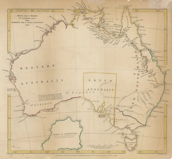
Sketch map to illustrate Dr. Leichardt's route from Moreton Bay to Port Essington, 1846Royal Geographical Society (RGS)Series: LondonRoyal Geographical Society (RGS), Sketch map to illustrate Dr. Leichardt's route from Moreton Bay to Port Essington, 1846£ 225.00
-
Thomas Ham, Victoria, 1847£ 3,850.00
-
Royal Geographical Society (RGS), Western Australia, Mount Fairfax to Perth, 1848£ 175.00
-
John Rapkin, Australia, 1850 c.£ 285.00
-
John Tallis, New South Wales, 1851£ 385.00
-
John Tallis, South Australia, Spencer Gulf and Kangaroo Island, 1851£ 425.00
-
John Tallis, Victoria or Port Phillip, 1851£ 425.00
-
John Tallis, Tasmania, 1851£ 445.00
-
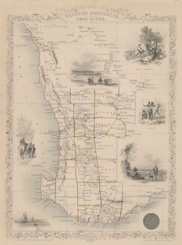
John Tallis, Western Australia, 1851£ 495.00
-
Course of the Maranoa, Victoria (Barcoo), and Warrego Rivers, 1852Royal Geographical Society (RGS)Series: LondonRoyal Geographical Society (RGS), Course of the Maranoa, Victoria (Barcoo), and Warrego Rivers, 1852£ 125.00
-
Wester Australia, Routes from Perth to Shark Bay and Russel Range, 1852Royal Geographical Society (RGS)Series: LondonRoyal Geographical Society (RGS), Wester Australia, Routes from Perth to Shark Bay and Russel Range, 1852£ 265.00
-
George Philip & Son Ltd., Australia, 1856£ 550.00


Page
1
of 3