West & Southwest London Maps
-
 Willem & Jan Blaeu, Middlesex, or North & West London, 1650 c.£ 725.00
 -
Richard Blome, Middlesex, or North & West London, 1673£ 475.00
-
John Seller, Middlesex, 1690 c.£ 195.00
-
John Norden, Westminster, 1723£ 295.00
-
John Rocque, Plan of the Royal Palace and Gardens of Hampton Court Palace, 1736£ 1,150.00
-
John Rocque, Middlesex, or North & West London, 1757£ 1,450.00
-
John Gwynn, Hyde Park, Mayfair and Westminster, 1766£ 1,650.00
-
Russell & Price, Middlesex, 1769£ 115.00
-
Thomas Bowen, County of Middlesex, 1777£ 585.00
-
Richard Horwood, Knightsbridge, 1794£ 1,950.00
-
George Bickham, Bird's-Eye view of London, 1796£ 550.00
-
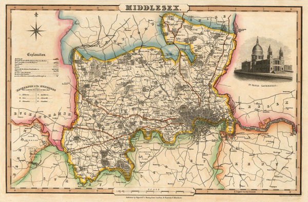
John Cary, A New Map of Middlesex, 1801£ 525.00
-
Thomas Faulkner, Chelsea, 1810£ 1,150.00
-
Hansard, St. James's Park Improvement Plan, 1827£ 1,450.00
-
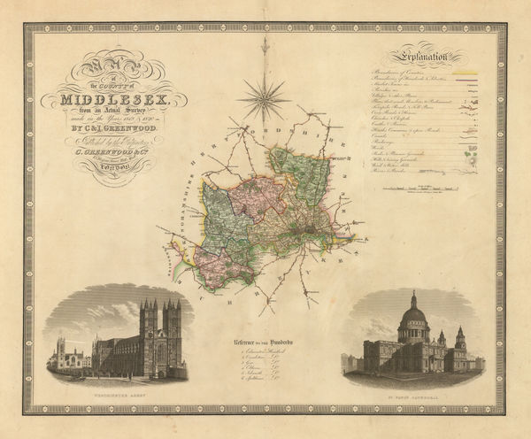
Christopher & John Greenwood, Map of the County of Middlesex, 1829£ 475.00
-
Joshua Archer, Middlesex, 1830 c.£ 44.00
-
Isaac Slater, Middlesex, 1830 c.£ 180.00
-
-
-
James Wyld, Clapham, Battersea, Brixton, Streatham, Tooting & Camberwell, 1849£ 1,250.00
-
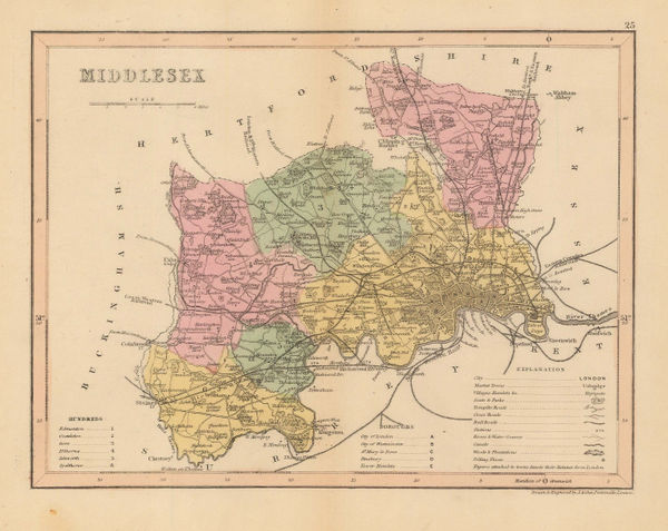
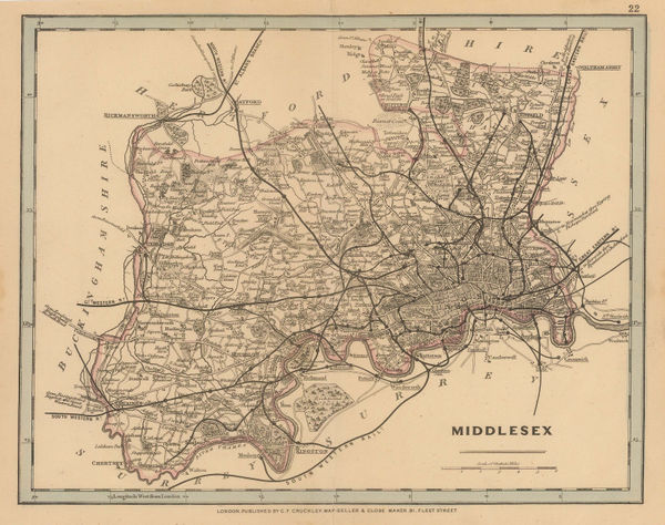
George Frederick Cruchley, Middlesex, 1850 c.£ 48.00
-
Edward Weller, London (South West Sheet), 1863£ 2,550.00
-
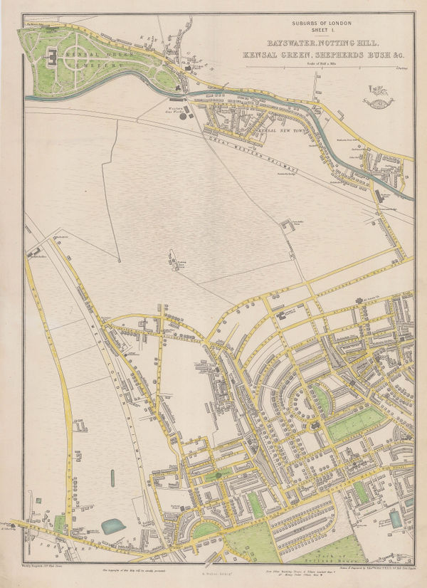
Edward Weller, Bayswater, Notting Hill, Kensal Green, Shepherds Bush &c., 1863£ 495.00
-
Edward Weller, Suburbs of London - Stockwell Clapham &c., 1863£ 285.00
-
Ordnance Survey, Knightsbridge & Kensington Gore, 1867£ 2,500.00
-
Ordnance Survey, Kensington Palace to Kensington Gore, 1867£ 1,850.00
-
John Cassell, Hammersmith, Shepherd's Bush & Holland Park, 1868£ 495.00
-
John Cassell, Paddington, Bayswater, Marylebone & Regent's Park, 1868£ 775.00
-
John Cassell, Kensal Green, Kilburn & Notting Hill, 1868£ 575.00
-
Ordnance Survey, Knightsbridge, Kensington & Brompton, 1869£ 3,500.00
-
Ordnance Survey, Knightsbridge & Belgravia, 1870£ 1,850.00
-
Alfred W. Oborne, Wimbledon Park Estate, 1875£ 885.00
-
Edward Stanford, West Central London, 1877£ 1,850.00
-
Edward Stanford, Fulham, Parson's Green & West Brompton, 1877£ 1,350.00
-
Edward Stanford, Chelsea, Battersea, Pimlico & Nine Elms, 1877£ 1,450.00
-
Edward Stanford, Kensington, Notting Hill, Bayswater & Holland Park, 1877£ 1,750.00
-
Edward Stanford, Wimbledon & Merton, 1877£ 675.00
-
Edward Stanford, Clapham, Balham, Upper Tooting & Streatham Hill, 1877£ 985.00
-
Edward Stanford, Putney, Wandsworth & Wimbledon, 1877£ 495.00
-
Edward Stanford, Tooting, Streatham & Mitcham, 1877£ 395.00
-
Thomas Sulman, Regent Street from Waterloo Place to Portland Place, 1880£ 185.00
-
Pettitt & Cox, The Wimbledon House Estate, 1880 c.£ 545.00
-
George W. Bacon, Clapham, Wandsworth & Battersea, 1880 c.£ 750.00
-
George W. Bacon, Fulham & Putney, 1880 c.£ 795.00
-
George W. Bacon, Stockwell, Brixton & Camberwell, 1880 c.£ 295.00
-
George W. Bacon, Wimbledon, Merton, Balham, Tooting & Streatham, 1880 c.£ 895.00
-
George W. Bacon, Notting Hill, Holland Park, Shepherds Bush & Kensal Green, 1885 c.£ 595.00
-
George W. Bacon, London (South West Sheet), 1885 c.£ 2,950.00
-
George W. Bacon, Battersea, Wandsworth & Clapham Junction, 1886£ 325.00
-
George W. Bacon, Clapham, Stockwell & Brixton, 1886£ 375.00
-
George W. Bacon, Notting Hill, Holland Park & Shepherd's Bush, 1886£ 395.00
-
George W. Bacon, Fulham, Putney, Parson's Green & Wandsworth, 1886£ 475.00
-
George W. Bacon, West London, 1886£ 395.00
-
George W. Bacon, West Central London, 1886£ 395.00
-
George W. Bacon, Ealing, Acton, Gunnersbury & Brentford, 1886£ 295.00
-
George W. Bacon, Hammersmith, Fulham, Baron's Court & Barnes, 1886£ 295.00
-
George W. Bacon, Hampton Court, Norbiton, Surbiton, Kingston & Thames Ditton, 1886£ 275.00
-
George W. Bacon, Central London, 1886£ 525.00
-
George W. Bacon, Fulham, Barnes, Putney, Wandsworth, 1886£ 545.00
-
George W. Bacon, Paddington, Bayswater, St. John's Wood & Maida Vale, 1886£ 395.00
-
Edward Stanford, Southwest London, 1886£ 1,450.00
-
George W. Bacon, Chelsea, Knightsbridge & Belgravia, 1886£ 845.00
-
George Philip & Son Ltd., The County of Middlesex, 1888£ 35.00
-
Charles Booth, Charles Booth's Poverty Map of London (NW), 1889£ 3,750.00
-
-
Charles Booth, Putney & Wandsworth Poverty Map, 1890 c.£ 450.00
-
Charles Booth, Fulham, West Brompton, Earl's Court, 1890 c.£ 1,150.00
-
Edward Stanford, Stanford's Map of the County of London - Sheet 17, 1894£ 925.00
-
Edward Stanford, Stanford's Map of the County of London - Sheet 6, 1894£ 325.00
-
Edward Stanford, Hampton Wick, Kingston, Norbiton & Petersham, 1894£ 475.00
-
George W. Bacon, Wimbledon, Merton & Earlsfield, 1895 c.£ 445.00
-
Charles Booth, Battersea & Clapham Poverty Map, 1900£ 1,650.00
-
Charles Booth, Poverty Map of Notting Hill, Hammersmith & West Kensington, 1900£ 1,650.00
-
George W. Bacon, South & Southwest London, 1900£ 395.00
-
George W. Bacon, Twickenham, Teddington & Richmond Park, 1900£ 295.00
-
George Philip & Son Ltd., Willesden, Cricklewood & Dollis Green, 1900 c.£ 36.00
-
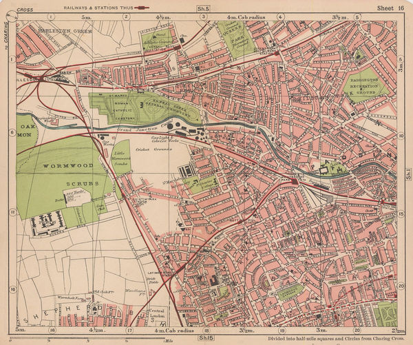
George W. Bacon, North Kensington, Kensal Green, Queens Park & Wormwood Scrubs, 1900 c.£ 165.00
-
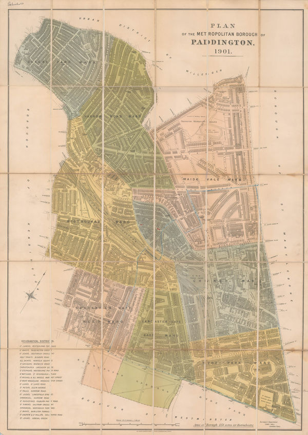
Sir Joseph Causton & Sons, The Metropolitan Borough of Paddington, 1901£ 950.00
-
George W. Bacon, Bayswater, Kensington, Paddington, Kilburn & Queens Park, 1902£ 68.00
-
Charles Edward Goad, Battersea Square, 1903£ 250.00


Page
1
of 2