
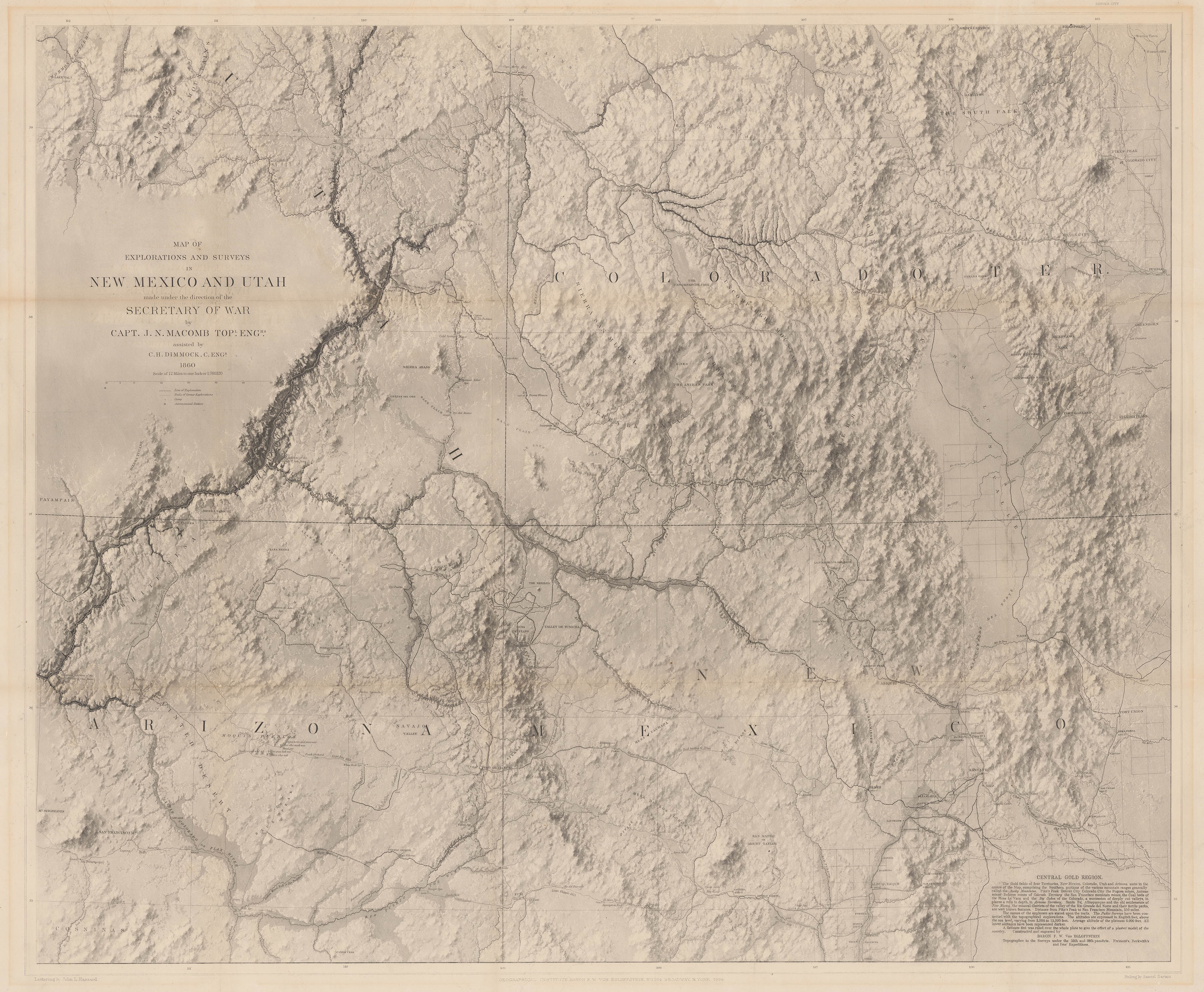
This month’s entry to Map of the Month, “Map of Exploration and Surveys in New Mexico and Utah”, by Captain John N. Macomb was published in 1864 and details the “Four Corners”: The area where the modern states of New Mexico, Arizona, Utah and Colorado meet.
Regarded as “one of the most beautiful maps ever published by the Army”, this extraordinary piece has the clarity and accuracy of a satellite image taken today. A map so advanced it has been highlighted as a cartographic landmark in the exploration of the American West
Captain John Navarre Macomb (1811-1889) was appointed Second Lieutenant in 1853 by the U. S. Army to assist in the Pacific Railroad Survey. The survey was a series of explorations to find routes for a trans-continental railroad across North America. It was an enormous undertaking spanning thousands of miles and employing people from many different disciplines to collate information for the United States War Department.
In 1859 Macomb was ordered to lead an expedition, separate from the Pacific Railroad Survey, to establish the best logistical routes for U.S. Army military supplies in the south-west. The route would unfold across the “Four Corners”, in part following the Santa Fé section of the Old Spanish Trail, (a historic trade route that in its entirety stretched over 1,200 miles between Santa Fé, New Mexico and Los Angeles, California).
As was common to these expeditions, Macomb was joined by a handful of seasoned explorers, botanists, geologists and artists to aid him in collecting information. Several of these gentlemen were veterans and had previously embarked on a similar expedition a few years earlier, exploring the length and environs of the Colorado River. (You can see these maps here and here).
For cartographic purposes the most important member of his team, and the man to patent and invent the method used to make the ‘Four Corners’ map, was Baron Frederick Wilhelm von Egloffstein. Egloffstein was a German-born American who joined the group after being conscripted by the U. S. Army.
When the American Civil War broke out Macomb’s expedition was halted, sending all of the party members home and giving Egloffstein the time and opportunity to create the ‘Four Corners’ map. His technique was innovative in theory and pioneering in practice. Taking the extensively described, photographed and sketched information from Macomb’s report, he was able to create a plaster cast model of the region. He then took an aerial photograph of the plaster cast, and pasted it to steel plate to engrave the details for printing. The result was incredible; even though he was using nineteenth century tools and equipment he had managed to create a map that successfully emulates satellite photography of the twenty first. The similarity between the two is quite uncanny.
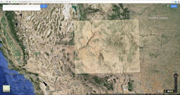
The images below compare a satellite photograph and a map of the terrain from Google Maps (2014), to Eggloffstein’s map. We have also superimposed the two to highlight the similarity.
Though ground-breaking, Egloffstein’s technique was not recognised as a productive or efficient method of map publication. The process was lengthy and rather expensive for the purposes of the U.S. Army. Though impractical for mass production, it was a notable achievement in the annals of cartography and created one of the finest maps of the nineteenth-century.