-
 Guillaume De L'Isle, The United States, the Caribbean, Mexico and Central America, 1783£ 3,950.00
 -
William Faden, Leeward and Windward Islands, 1784£ 3,650.00
-
A Chart of the English Channel with the Coasts of France, Spain, and Portugal, 1784John HarrisonSeries: LondonJohn Harrison, A Chart of the English Channel with the Coasts of France, Spain, and Portugal, 1784£ 95.00
-
Thomas Kitchin, Plan of St. Petersburg, 1784£ 395.00
-
Jacques-Nicolas Bellin, Carte Reduites des parties connues du Globe Terrestre, 1784£ 3,750.00
-
Andrew Bell, East Indies, 1784£ 275.00
-
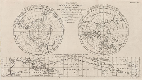
A Map of the World in Three Sections describing the Polar Regions to the Tropics, 1784Andrew BellSeries: LondonAndrew Bell, A Map of the World in Three Sections describing the Polar Regions to the Tropics, 1784£ 445.00
-
Francois Santini, Italy, Sicily, Sardinia and Corsica, 1784£ 425.00
-
Antonio Zatta, West Africa from Senegal to Ghana, 1784£ 175.00
-
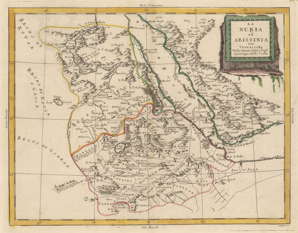
Antonio Zatta, Nubia (Sudan) and Abyssinia (Ethiopia and Eritrea), 1784£ 125.00
-
Antonio Zatta, India and Southeast Asia, 1784£ 625.00
-
Gerhard Friedrich Muller, Russian Discoveries in Siberia, Alaska & the Bering Strait, 1784£ 1,200.00
-
The London Directory, or a New & Improved Plan of London, Westminster, & Southwark, 1784Robert WilkinsonSeries: LondonRobert Wilkinson, The London Directory, or a New & Improved Plan of London, Westminster, & Southwark, 1784£ 1,350.00
-
Capt. James Cook, Botany Bay and the mouth of the Endeavour River, 1784£ 245.00
-
Joseph Tiefenthaler, The River Ganges, 1784£ 4,500.00
-
-
A Draught of Portland the Shambles and the Race of Portland, 1785Capt. Greenvile CollinsSeries: LondonCapt. Greenvile Collins, A Draught of Portland the Shambles and the Race of Portland, 1785£ 625.00
-
A New and Correct Plan of the Citie of London, Westminster and Borough of Southwark, 1785Robert SayerRobert Sayer, A New and Correct Plan of the Citie of London, Westminster and Borough of Southwark, 1785£ 1,850.00
-
John Harrison, South America with political divisions, 1785£ 92.00
-
Carington Bowles, Bowles's New Medium Map of Cornwall, Divided into its Hundreds, 1785£ 295.00
-
Carington Bowles, Bowles's New Medium map of Hereford Shire, 1785£ 65.00
-
Carington Bowles, Bowles's New Medium Map of Monmouth Shire, 1785£ 95.00
-
Capt. Greenvile Collins, Scarborough, Hartlepool, and Bridlington, 1785£ 275.00
-
One of the earliest maps to recognize the newly-independent United States, 1785Hendrik KlockhoffSeries: ParisHendrik Klockhoff, One of the earliest maps to recognize the newly-independent United States, 1785£ 2,450.00
-
Charles Francois Delamarche, Scarce early map of the newly-independent USA, 1785£ 1,850.00
-
Harwich, Woodbridg and Handfordwater with the Sands from Nazeland to Hosely Bay, 1785Capt. Greenvile CollinsSeries: LondonCapt. Greenvile Collins, Harwich, Woodbridg and Handfordwater with the Sands from Nazeland to Hosely Bay, 1785£ 1,250.00
-
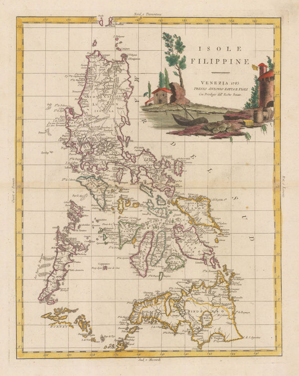
Antonio Zatta, Philippine Islands, 1785£ 1,950.00
-
Antonio Zatta, Japan divided into six regions, 1785£ 1,650.00
-
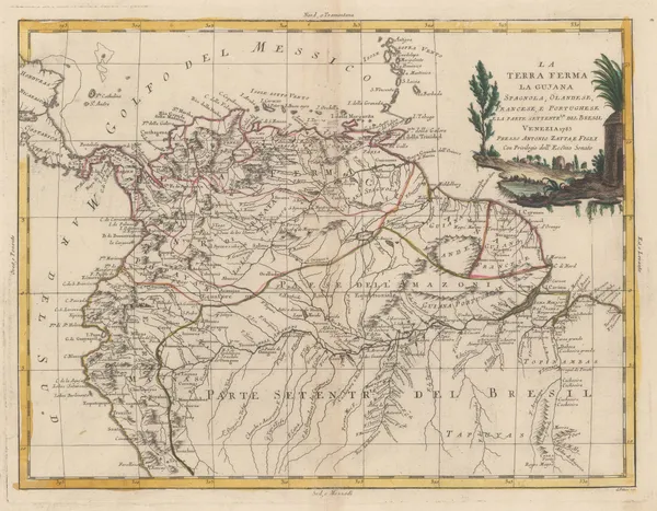
Antonio Zatta, Northern half of South America, 1785£ 525.00
-
Capt. Greenvile Collins, Milford-Haven, 1785£ 395.00
-
J.C. & J.A. Dezauche, Auvergne, Rouergue, and Quercy, 1785£ 245.00
-
Capt. Greenvile Collins, Plymouth, 1785£ 495.00
-
Antonio Zatta, Malay Peninsula and Bay of Bengal, 1785£ 1,150.00
-
Capt. Greenvile Collins, The East Coast of Scotland, 1785£ 445.00
-
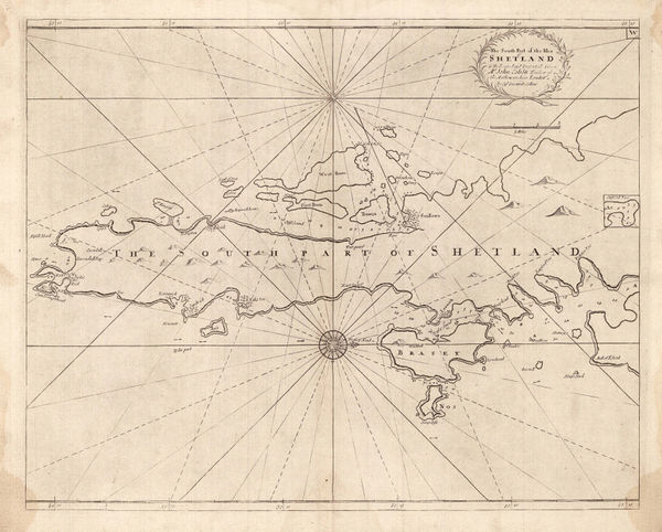
Capt. Greenvile Collins, The South Part of the Isles of Shetland, 1785£ 385.00
-
Capt. Greenvile Collins, Yarmouth and the Sands about it, 1785£ 395.00
-
Capt. Greenvile Collins, Sea Chart of Land's End & the Scilly Isles, 1785£ 445.00
-
Capt. Greenvile Collins, Sea Chart of the Devon Coast, 1785£ 595.00
-
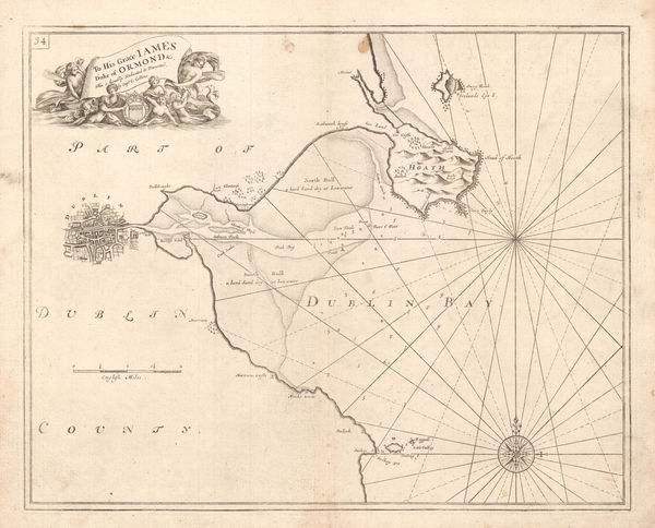
Capt. Greenvile Collins, Dublin Bay, 1785£ 745.00
-
Capt. Greenvile Collins, Sea Chart of the Harbours of Dundee, Aberdeen & Montrose, 1785£ 495.00
-
Capt. Greenvile Collins, Isle of Wight, 1785£ 1,250.00
-
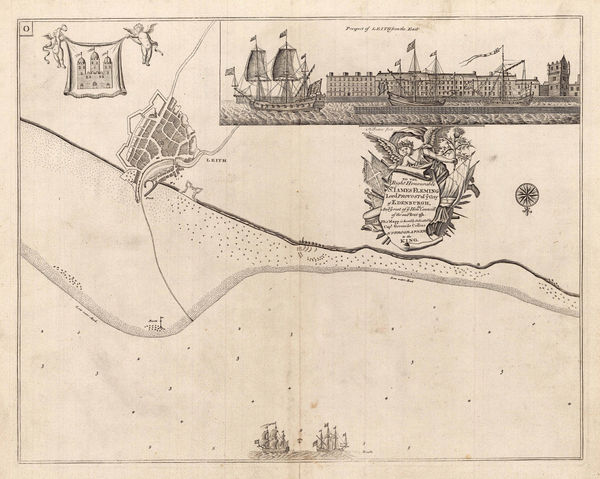
Capt. Greenvile Collins, Sea Chart of Leith, Edinburgh, 1785£ 575.00
-
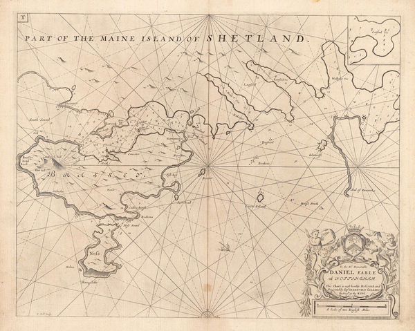
Capt. Greenvile Collins, Shetland - Lerwick, Bressay & Noss, 1785£ 345.00
-
Capt. Greenvile Collins, Sea Chart of the North Sea & East Coast of England, 1785£ 785.00
-
Capt. Greenvile Collins, St. George's Channel, 1785£ 445.00
-
Capt. Greenvile Collins, English Sea Chart of the North Sea, 1785£ 745.00
-
Capt. Greenvile Collins, Bristol, 1785£ 445.00
-
Thomas Kitchin, Italy, 1785£ 195.00
-
Thomas Kitchin, Africa, 1785£ 225.00
-
Carington Bowles, Sussex, 1785£ 325.00
-
Antonio Zatta, Stato del Mogol, 1785£ 795.00
-
Thomas Kitchin, South America, 1785£ 145.00
-
Pierre Tardieu, Europe showing political borders, 1785£ 75.00
-
Paul de Rapin & Nicolas Tindal, Attack of the Rebels upon Fort Penobscot, 1785£ 1,950.00
-
Pierre Tardieu, Diametres du Soleil et des Planetes comparés à celiu de la Terre, 1785£ 275.00
-
John Chapman & Peter André, Monumental Wall Map of Essex, 1785£ 4,500.00
-
Capt. James Cook, Hawaii, 1785£ 1,850.00
-
A Plan of the Cities of London and Westminster, The Borough of Southwark and their Suburbs, 1785William FadenWilliam Faden, A Plan of the Cities of London and Westminster, The Borough of Southwark and their Suburbs, 1785£ 2,750.00
-
Pierre Tardieu, South America divided into Spanish provinces, 1785£ 85.00
-
Antonio Zatta, Mexico, Texas & the Southern USA, 1785£ 795.00
-
James Rennell, Ganges Delta, 1785£ 1,450.00
-
William Guthrie, Chart of the World, 1785 c£ 275.00
-
Bowles & Carver, Worcestershire, 1785 c£ 195.00
-
William Guthrie, Newly-independent United States, 1785 c.£ 945.00
-
Tardieu, Eastern United States, 1785 c.£ 745.00
-
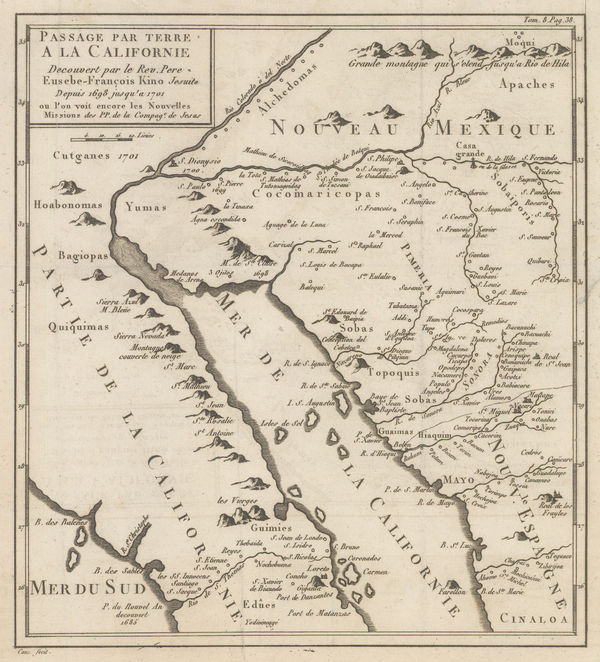
Late French rendition of the important map by Eusebio Kino, 1785 c.Eusebio Francisco KinoSeries: ParisEusebio Francisco Kino, Late French rendition of the important map by Eusebio Kino, 1785 c.£ 885.00
-
Rigobert Bonne, The World on Mercator's Projection, 1785 c.£ 295.00
-
Robert Sayer, A Chart of the Island of Jersey, 1786£ 1,850.00
-
Robert Sayer, A New Hydrographic Sketch of the North, South and Middle Channels, 1786£ 495.00
-
-
-
Vicente Maria Tofino, Rare Spanish Sea Chart of Mallorca, Menorca & Ibiza, 1786£ 3,450.00
-
Jacques-Nicolas Bellin, Chart of the North Atlantic Ocean, 1786£ 1,200.00
-
Thomas Kitchin, Oxfordshire, 1786£ 82.00
-
Vicente Maria Tofino, Rare Spanish Chart of Gibraltar, 1786£ 1,450.00
-
-
Vicente Maria Tofino, Rare Spanish Sea Chart of Ibiza & Formentera, 1786£ 3,450.00
-
Thomas Bowen, Very early map of the newly formed United States, 1787£ 985.00
-
-
John Seller, Berkshire, 1787£ 95.00


Page
45
of 130