-
 John Cary, Staffordshire, 1793£ 72.00
 -
John Cary, Westmoreland, 1793£ 72.00
-
John Cary, Cumberland, 1793£ 88.00
-
Charles Stedman, Sketch of General Grants Position on Long Island, 1793£ 1,250.00
-
Laurie & Whittle, A Chart of the Coast of India, from Goa to Cape Comorin, 1794£ 1,250.00
-
Laurie & Whittle, Madeira & the Canary Islands, 1794£ 925.00
-
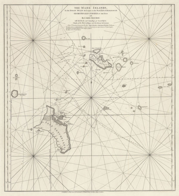
Laurie & Whittle, A Chart of the Mahe and Amirantes Islands, 1794£ 2,450.00
-
Laurie & Whittle, A Chart of the Nicobar Islands in the Gulf of Bengal, 1794£ 750.00
-
Laurie & Whittle, Chart of the East China Sea, 1794£ 2,450.00
-
Laurie & Whittle, A Chart of the Northern Part of the Indian Ocean, 1794£ 2,850.00
-
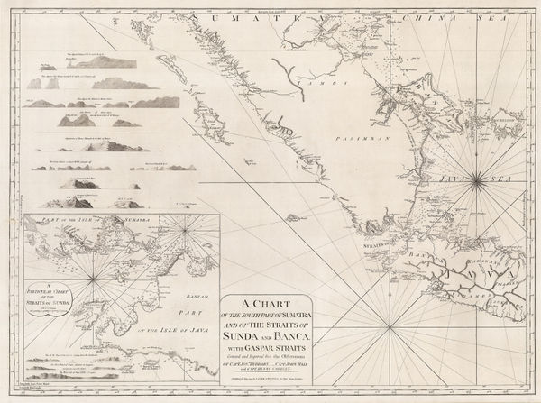
A Chart of the Southern Part of Sumatra and of the Straits of Sunda and Banca, 1794Laurie & WhittleSeries: LondonLaurie & Whittle, A Chart of the Southern Part of Sumatra and of the Straits of Sunda and Banca, 1794£ 925.00
-
John Armstrong, Menorca, 1794£ 2,750.00
-
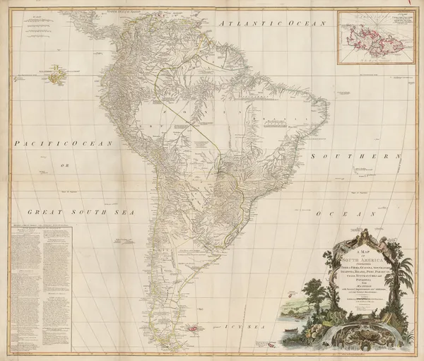
Laurie & Whittle, Wall map of South America, 1794£ 4,950.00
-
Laurie & Whittle, Uttar Pradesh, 1794£ 450.00
-
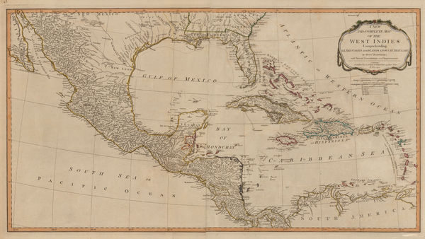
Laurie & Whittle, Central America and the West Indies, 1794£ 985.00
-
A New and General Map of the Southern Dominions Belonging to The United States of America, 1794Laurie & WhittleSeries: LondonLaurie & Whittle, A New and General Map of the Southern Dominions Belonging to The United States of America, 1794£ 3,500.00
-
Laurie & Whittle, Chart of entrance to the Hooghly River, 1794£ 1,650.00
-
Laurie & Whittle, A New Chart of the Southern Coast of Africa, 1794£ 3,250.00
-
Laurie & Whittle, Chart of the South Atlantic, 1794£ 750.00
-
Robert Wilkinson, Miniature map of South America, 1794£ 155.00
-
Laurie & Whittle, Switzerland, 1794£ 200.00
-
Laurie & Whittle, The Kingdom of France, 1794£ 375.00
-
Laurie & Whittle, Spain, Portugal and the Balearic Islands, 1794£ 445.00
-
Laurie & Whittle, Belgium, 1794£ 225.00
-
Laurie & Whittle, Bali Strait, 1794£ 395.00
-
Laurie & Whittle, A Plan of Table Bay with the Road of the Cape of Good Hope, 1794£ 2,950.00
-
Laurie & Whittle, Rare chart of the Pearl River, 1794£ 4,250.00
-
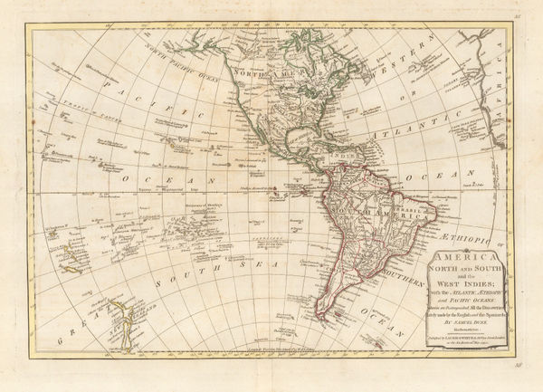
Laurie & Whittle, America North and South and the West Indies, 1794£ 525.00
-
Laurie & Whittle, Bay of Biscay, 1794£ 1,250.00
-
Robert Wilkinson, The West Indies, 1794£ 195.00
-
Laurie & Whittle, Sea Chart of the Devon Coast from Exmouth Bar to Stoke Point, 1794£ 650.00
-
Laurie & Whittle, Chart of the Entrance of Hudson's River, 1794£ 3,750.00
-
Laurie & Whittle, Chart of the west Coast of Sumatra, 1794£ 495.00
-
Laurie & Whittle, Egypt and the Nile, 1794£ 275.00
-
Capt. James Cook, Coast of New Caledonia, 1794£ 185.00
-
Charles Francois Delamarche, French map of Asia, 1794£ 225.00
-
Bryan Edwards, Dominica, 1794£ 225.00
-
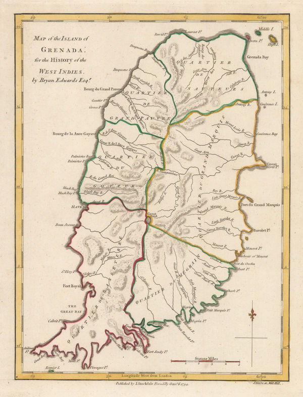
Bryan Edwards, Grenada divided into quartiers, 1794£ 195.00
-
Bryan Edwards, Map of the Island of St. Vincent, 1794£ 225.00
-
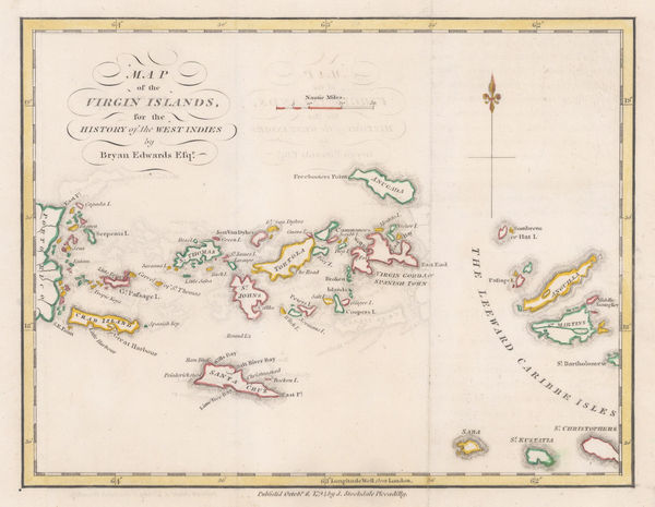
Bryan Edwards, Map of the Virgin Islands for The History of the West Indies, 1794£ 895.00
-
-
Laurie & Whittle, Phuket and the Mergui Archipelago, 1794£ 795.00
-
Laurie & Whittle, Chart of the Riau Islands in the Singapore Strait, 1794£ 1,250.00
-
Laurie & Whittle, Chart of Subic Bay on Luzon Island, 1794£ 825.00
-
Capt. James Cook, Dusky Sound and Resolution Island, 1794£ 295.00
-
The Coast of India and China from the Point and River of Camboja to Canton, 1794Laurie & WhittleSeries: LondonLaurie & Whittle, The Coast of India and China from the Point and River of Camboja to Canton, 1794£ 2,250.00
-
The Coast of India between Calymere and Gordeware Points including the Coast of Coromandel, 1794Laurie & WhittleSeries: LondonLaurie & Whittle, The Coast of India between Calymere and Gordeware Points including the Coast of Coromandel, 1794£ 1,250.00
-
Laurie & Whittle, The Coast of India from Point Gordeware to the Ganges, 1794£ 985.00
-
Laurie & Whittle, The Coast of India from Point Jigat to Cape Ramas, 1794£ 1,250.00
-
Laurie & Whittle, Rare chart of the Gulf of Thailand and the South China Sea, 1794£ 1,350.00
-
Laurie & Whittle, European Russia, 1794£ 495.00
-
Laurie & Whittle, Bohemia and Silesia, 1794£ 385.00
-
John Cary, The London Docks, 1794£ 895.00
-
Laurie & Whittle, The Seychelles, or Mahe Islands, 1794£ 2,450.00
-
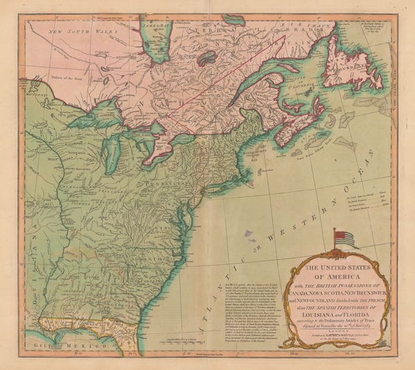
Laurie & Whittle, The United States of America, 1794£ 3,000.00
-
Capt. James Cook, Van Kerguelens Land, 1794£ 145.00
-
Charles Stedman, Revolutionary War- Battle of the Capes, 1794£ 495.00
-
Richard Horwood, Knightsbridge, 1794£ 1,950.00
-
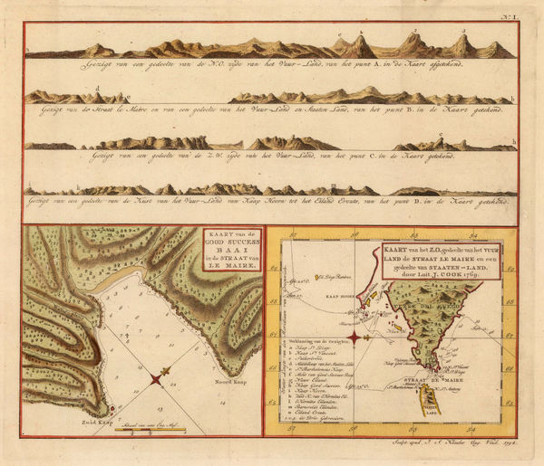
Capt. James Cook, Le Maire Straits, 1794£ 295.00
-
William Guthrie, The United States of America, 1794£ 295.00
-
Bryan Edwards, Barbados, 1794£ 465.00
-
Charles Stedman, Plan of the siege of Yorktown in Virginia , 1794£ 2,250.00
-
William Faden, Scandinavia, 1794£ 1,350.00
-
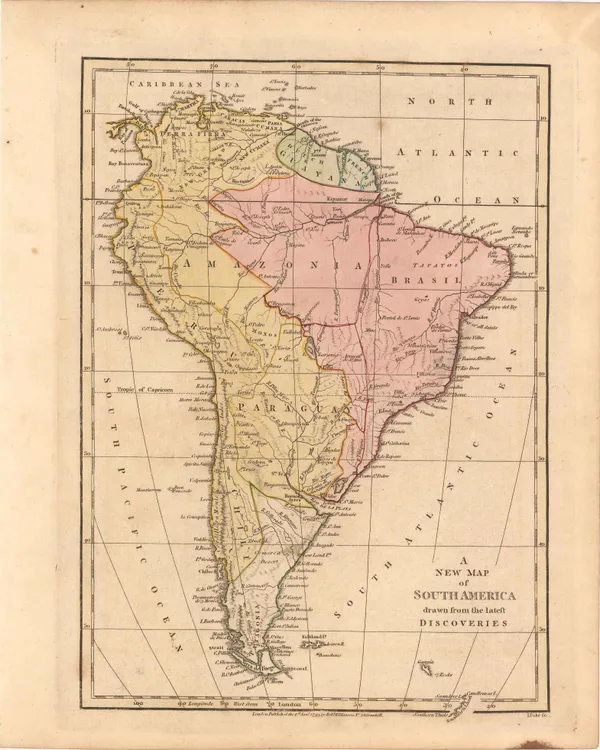
Bowles & Carver, Bowles's New One-Sheet Map of South America, 1794 c.£ 925.00
-
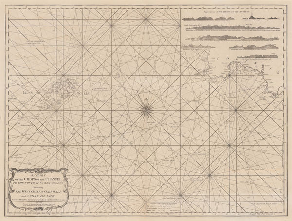
A Chart of the Chops of the Channel, to the South of Scilly Islands: Containing the West Coast of Cornwall and Scilly Islands, 1795Laurie & WhittleSeries: LondonLaurie & Whittle, A Chart of the Chops of the Channel, to the South of Scilly Islands: Containing the West Coast of Cornwall and Scilly Islands, 1795£ 545.00
-
Smith, Reid & Wayland, North America with manuscript annotations, 1795£ 985.00
-
William Faden, Northern France and Southern Belgium, 1795£ 140.00
-
William Heather, Caribbean Islands from the Virgin Islands to Trinidad and Tobago, 1795£ 1,950.00
-
Franz Ludwig Gussefeld, The West Indies, 1795£ 1,175.00
-
Charles Francois Delamarche, Southern & Central Africa, 1795£ 325.00
-
Franz Von Reilly, Das Konigreich England Nach Kitchin, 1795£ 380.00
-
John Russell, Dominions of Russia, 1795£ 58.00
-
William Faden, European Dominions of the Ottomans or Turkey in Europe, 1795£ 695.00
-
John Russell, France, 1795£ 48.00
-
Antonio Zatta, China and Japan, 1795£ 725.00
-
Charles Francois Delamarche, India and Southeast Asia, 1795£ 285.00
-
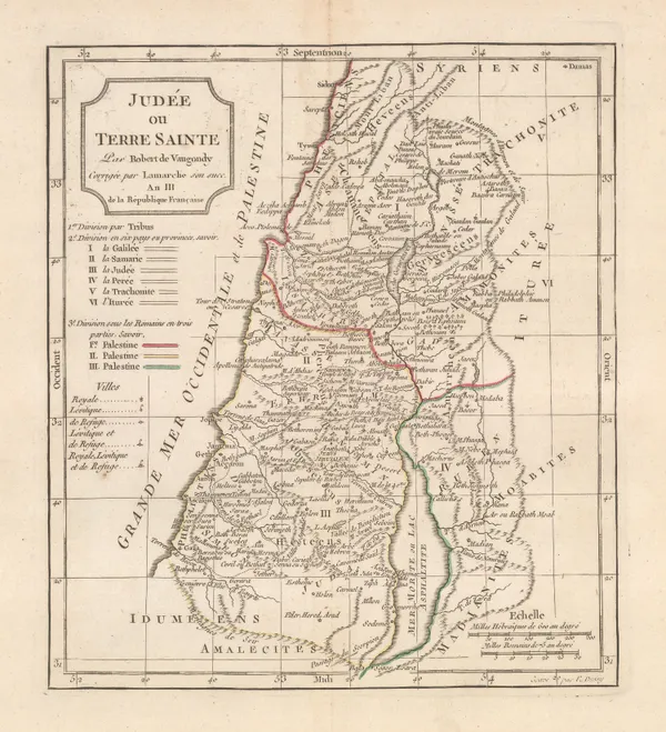
Charles Francois Delamarche, Holy Land, 1795£ 175.00
-
Franz Anton Schraembl, Rare, very early map of Port Jackson and environs, 1795£ 825.00
-
Franz Von Reilly, Kingdom of Portugal with diagram of the Solar system, 1795£ 180.00
-
Franz Von Reilly, France, 1795£ 100.00


Page
47
of 130