-
 The County of Suffolk, reduced from the Large Map in Six Sheets Surveyed by Joseph Hodskinson; & planned from a Scale of Half an Inch to One Mile, 1797William FadenSeries: LondonWilliam Faden, The County of Suffolk, reduced from the Large Map in Six Sheets Surveyed by Joseph Hodskinson; & planned from a Scale of Half an Inch to One Mile, 1797£ 650.00
 -
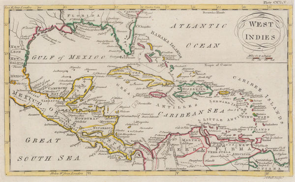
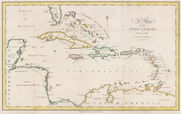
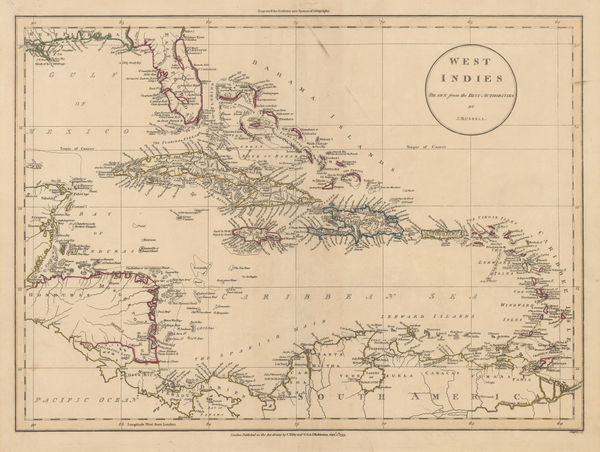
Andrew Bell, West Indies, 1797£ 195.00
-
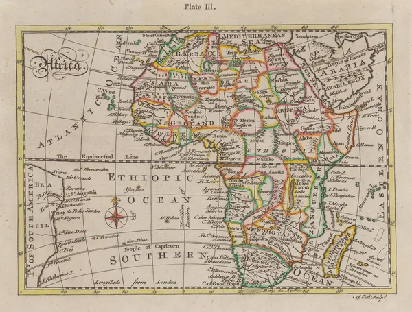
Andrew Bell, Africa, 1797£ 165.00
-
Count Jean-Francois de la Perouse, Chart of the North Pacific, 1797£ 750.00
-
Laurie & Whittle, A Hydrographic Survey of False Bay or Bay False, 1798£ 1,650.00
-
John Wilkes, Ancient Africa, 1798£ 145.00
-
William Faden, North Africa from Morocco to Libya, 1798£ 92.00
-
William Faden, East coast of the USA and Canada, 1798£ 385.00
-
William Faden, Miniature map of China, Japan and Korea, 1798£ 295.00
-
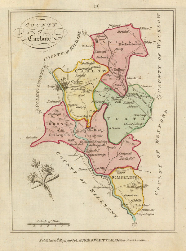
Laurie & Whittle, County of Carlow, 1798£ 85.00
-
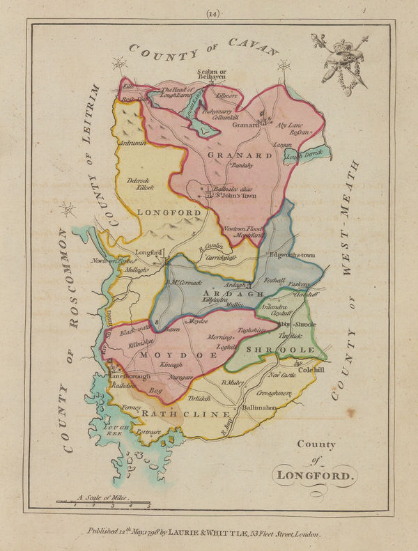
Laurie & Whittle, County of Longford, 1798£ 125.00
-
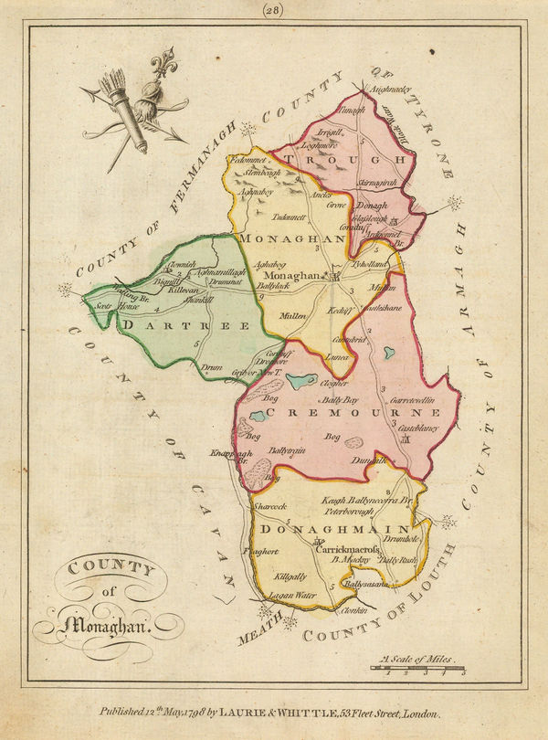
Laurie & Whittle, County of Monaghan, 1798£ 95.00
-
William Faden, Europe and its General Divisions, 1798£ 245.00
-
Pierre Tardieu, Southern India and Sri Lanka (Ceylon), 1798£ 175.00
-
-
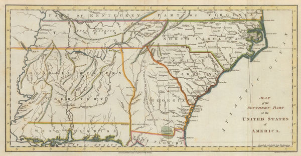
John Russell, Map of the Southern Part of the United States of America, 1798£ 745.00
-
Teodore Viero, Venice, 1798£ 2,450.00
-
John Stockdale, Eastern United States, 1798£ 845.00
-
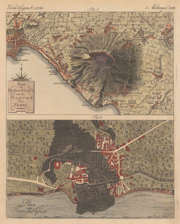
Friedrich Justin Bertuch, Naples and Mt Vesuvius with Torre del Greco, 1798£ 125.00
-
Friedrich Justin Bertuch, Caves of Maastricht, 1798Sold
-
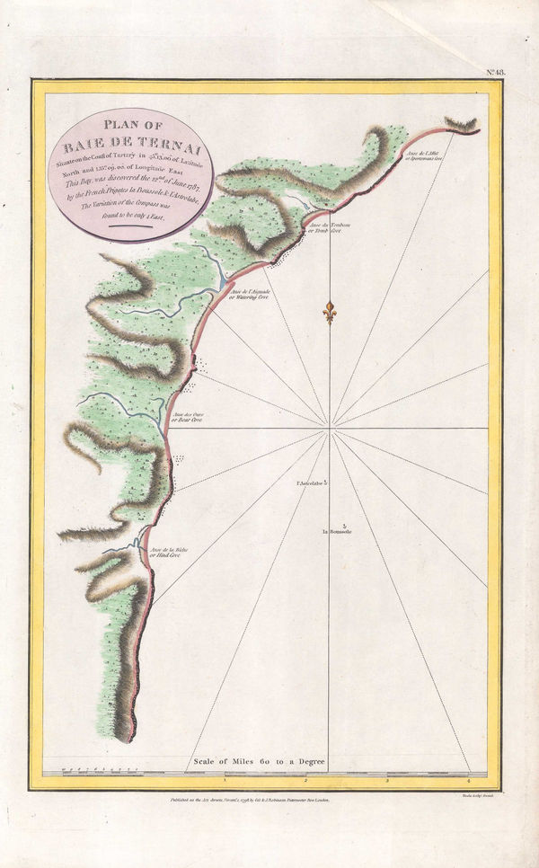
Jean Francois de La Perouse, Bay of Terney, Siberia, 1798£ 70.00
-
John Brydon, Battle of the Nile, 1798£ 4,950.00
-
Laurie & Whittle, Plymouth Sound, Hamoaze & Catwater, 1798£ 595.00
-
William Faden, Poland, Prussia and Lithuania, 1798£ 185.00
-
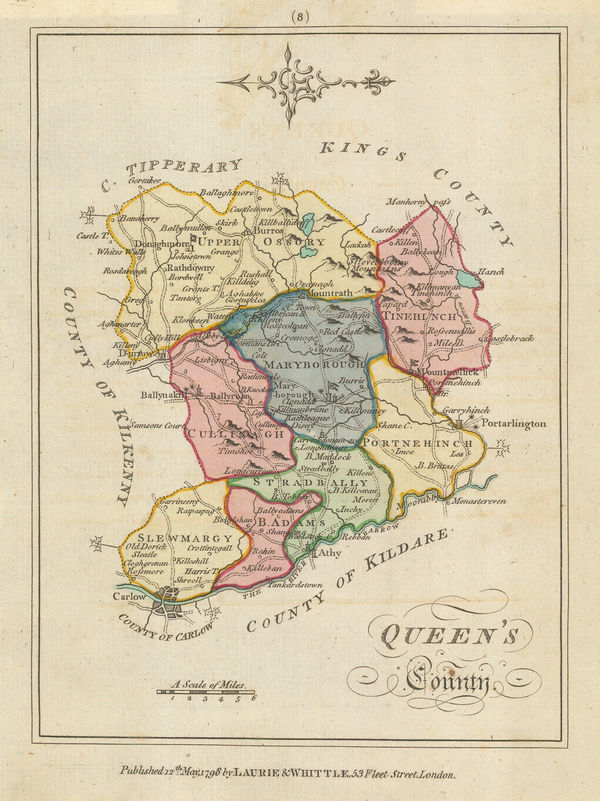
Laurie & Whittle, Queens County, 1798£ 62.00
-
William Faden, Miniature Map of Siberia, 1798£ 95.00
-
John Walker, South America, 1798£ 78.00
-
William Faden, India and Southeast Asia, 1798£ 175.00
-
James Rennell, The Lines of Magnetic Variations in the Seas around Africa, 1798£ 385.00
-
William Faden, The New World and the Old World, 1798£ 525.00
-
William Faden, Western Coast of North America, 1798£ 345.00
-
The Division of the World between the Sons of Noah after the Great Flood, 1798Robert WilkinsonSeries: LondonRobert Wilkinson, The Division of the World between the Sons of Noah after the Great Flood, 1798£ 195.00
-
John Wilkes, Astronomy - Phenomena of the Moon, 1798£ 275.00
-
John Wilkes, The Ptolemaic, Tychonic and Copernican Systems, 1798£ 325.00
-
Jedediah Morse, A Map of the Northern and Middle States, 1798£ 925.00
-
John Walker, Hindoostan, or India, 1798£ 75.00
-
Robert Wilkinson, The Land of Moriah or Jerusalem and the Adjacent Country, 1798£ 350.00
-
Robert Wilkinson, Ancient Persian Empire, 1798£ 175.00
-
J. Coche, Brussels (Bruxelles), 1798 c.£ 895.00
-
John Stockdale, The West Indies or Caribbean, 1799£ 225.00
-
John Cary, Ireland divided into provinces and counties, 1799£ 625.00
-
John Cary, Russian Empire in the Napoleonic era, 1799£ 925.00
-
John Cary, The Netherlands, 1799£ 165.00
-
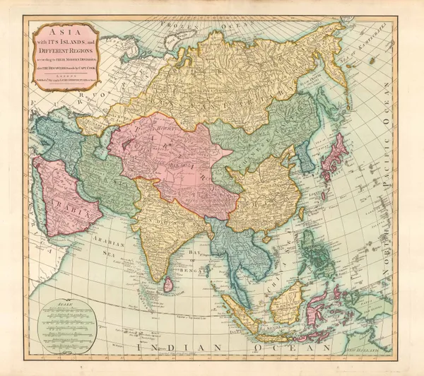
John Russell, Asia, 1799£ 245.00
-
Laurie & Whittle, Asia with its Islands, and Different Regions, 1799£ 465.00
-
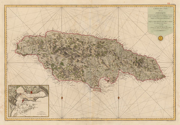
Depot de la Marine, Jamaica, 1799£ 725.00
-
-
John Russell, North America, 1799£ 850.00
-
Anonymous, Southern France, 1799£ 565.00
-
William Faden, Provence & the South of France, 1799£ 950.00
-
John Russell, West Indies, 1799£ 395.00
-
Richard Horwood, Southwark, Bermondsey, Rotherhithe & Wapping, 1799£ 4,850.00
-
William Heather, Sea Chart of the South Atlantic & South America, 1799£ 2,250.00
-
Franz Von Reilly, Isle of Man, 1799£ 395.00
-
William Faden, A Map of the Peninsula of India, 1800£ 1,550.00
-
William Heather, Chart of the coast of Portugal and Spain, 1800£ 1,550.00
-
William Heather, Two charts of Islands in the Banda Sea, 1800Reserved
-
John Stockdale, Venice, 1800£ 375.00
-
Michael Symes, Myanmar (Burmese Empire) and Indo-China, 1800£ 245.00
-
George Cooke, Asia, 1800£ 155.00
-
Tardieu, North and South Carolina and Virginia, 1800£ 825.00
-
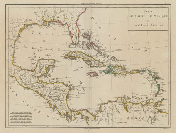
Pierre Tardieu, The West Indies and Central America, 1800£ 525.00
-
Ferdinand Gotze, Survey of the Black Sea coast, 1800£ 395.00
-
George Cooke, Southeast Asia, 1800£ 175.00
-
George Cooke, Hindoostan, 1800£ 325.00
-
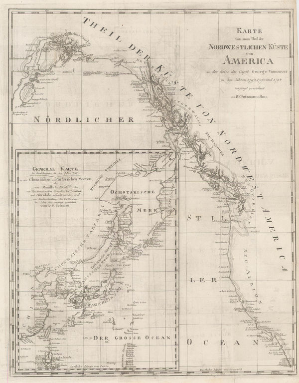
Daniel Friedrich Sotzmann, North West Pacific coast of America, 1800£ 795.00
-
Charles Francois Delamarche, L'Amerique, 1800£ 1,950.00
-
New Pocket Plan of the Cities of London and Westminster with the Borough of Southwark, 1800Bowles & CarverSeries: LondonBowles & Carver, New Pocket Plan of the Cities of London and Westminster with the Borough of Southwark, 1800£ 895.00
-
Carl Jaettnig, Eastern United States, 1800£ 545.00
-
Laurie & Whittle, Plan of the Isle of Trinidad, 1800£ 2,850.00
-
George Cooke, Russia in Europe, 1800£ 225.00
-
Scotland drawn and engraved from a series of Angles and Astronomical Observations, 1800John AinslieSeries: EdinburghJohn Ainslie, Scotland drawn and engraved from a series of Angles and Astronomical Observations, 1800£ 4,500.00
-
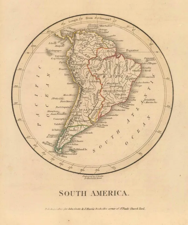
George Cooke, South America, 1800£ 165.00
-
George Cooke, Miniature map of Greece and the Balkans, 1800£ 125.00
-
Darton & Harvey, London, Westminster & Southwark, 1800£ 1,450.00
-
Robert Wilkinson, Roman Britain, 1800£ 165.00
-
Robert Wilkinson, Saxon England, 1800£ 185.00
-
Robert Wilkinson, Siciliae Antiquae Tabula, 1800£ 145.00
-
Robert Wilkinson, Roman Britain, 1800£ 145.00
-
William Heather, Chart of the Cape Verde Islands, 1800 c.£ 325.00


Page
49
of 130