-
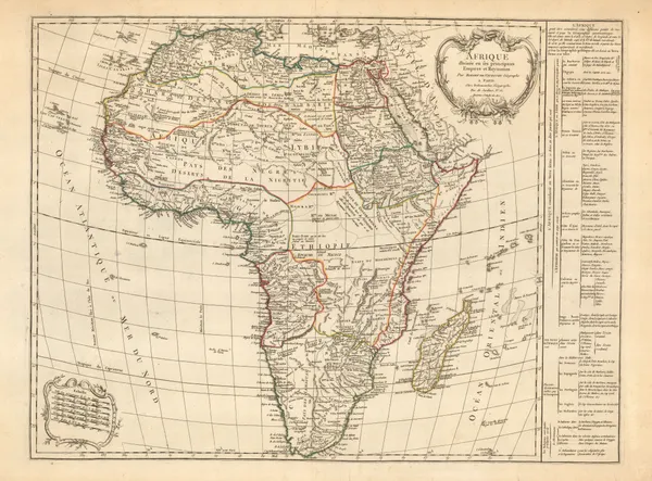
 Charles Francois Delamarche, Africa, 1800 c.£ 825.00
 -
John Russell, Asia, 1800 c.£ 44.00
-
Voyage en Italie, City plan of Parma, 1800 c.£ 240.00
-
Voyage en Italie, City plan of Mantua, 1800 c.£ 240.00
-
Voyage en Italie, City plan of Naples, 1800 c.£ 260.00
-
Thomas Jefferys, Plan of La Hogue with the Intended Works, 1800 c.£ 75.00
-
John Cary, Warwickshire, 1800 c.£ 45.00
-
William Heather, Plymouth Sound, Portland and Falmouth & Helford, 1800 c.£ 950.00
-
-
William Faden, A Map of England, Wales and Scotland, 1801£ 825.00
-
T. Chantry, Bath, 1801£ 1,750.00
-
-
William Heather, Chart of Madeira and the Canary Islands, 1801£ 1,450.00
-
John Cary, A New Map of Bedfordshire, 1801£ 245.00
-
John Cary, A New Map of Berkshire, 1801£ 425.00
-
John Cary, A New Map of Buckinghamshire, 1801£ 325.00
-
John Cary, A New Map of Cumberland, 1801£ 295.00
-
John Cary, A New Map of Derbyshire, 1801£ 295.00
-
John Cary, A New Map of Essex, 1801£ 445.00
-
John Cary, A New Map of Hertfordshire, 1801£ 275.00
-
John Cary, A New Map of Huntingdonshire Divided into Hundreds, 1801£ 75.00
-
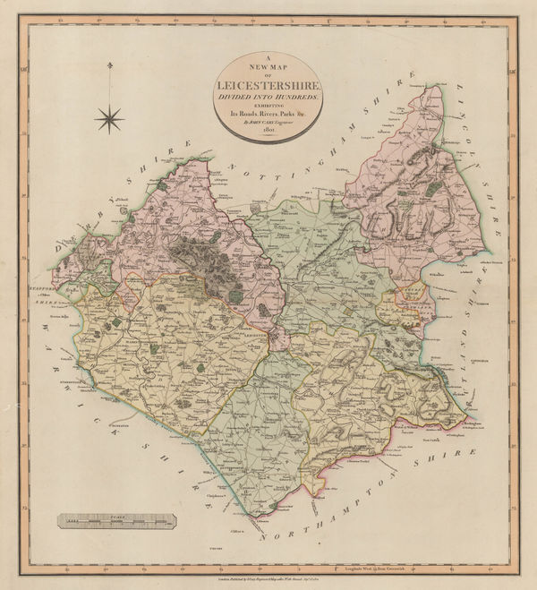
John Cary, A New Map of Leicestershire, 1801£ 395.00
-
John Cary, A New Map of Middlesex, 1801£ 525.00
-
A New Map of Nottinghamshire divided into Hundreds exhibiting its Roads, Rivers, Parks &c., 1801John CarySeries: LondonJohn Cary, A New Map of Nottinghamshire divided into Hundreds exhibiting its Roads, Rivers, Parks &c., 1801£ 285.00
-
John Cary, A New Map of Scotland, 1801£ 1,550.00
-
John Cary, A New Map of Somersetshire, 1801£ 395.00
-
John Cary, A New Map of Sussex, 1801£ 545.00
-
John Cary, Scandinavia, 1801£ 350.00
-
John Cary, A New Map of Turkey in Europe, 1801£ 325.00
-
John Cary, A New Map of Westmoreland, 1801£ 245.00
-
John Cary, A New Map of Worcestershire, 1801£ 295.00
-
John Wilkes, Berkshire, 1801£ 78.00
-
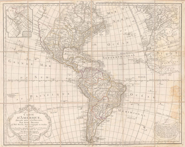
J.C. & J.A. Dezauche, Carte d'Amerique, 1801£ 850.00
-
Johann Christoph Reinecke, German atlas map of India, and South East Asia, 1801£ 1,250.00
-
Laurie & Whittle, Switzerland, 1801£ 95.00
-
William Guthrie, Switzerland, 1801£ 78.00
-
William Heather, The Entrances to the River Thames, 1801£ 1,650.00
-
Richard Warner, Plan of the City of Bath A.D.1717, 1801£ 525.00
-
John Cary, A Map of Wiltshire, 1801£ 325.00
-
John Wallis, Wallis's Plan of the Cities of London and Westminster, 1801£ 1,950.00
-
John Cary, A New Map of Surrey, 1801£ 595.00
-
William Guthrie, The West Indies or Caribbean, 1801£ 145.00
-
John Cary, A New Map of Northamptonshire, 1801£ 275.00
-
John Cary, Portugal during the Napoleonic Wars, 1801£ 175.00
-
John Cary, A New Map of Persia from the Latest Authorities, 1801£ 425.00
-
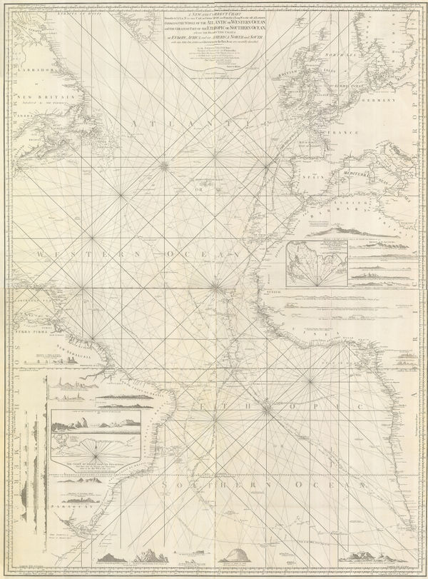
Laurie & Whittle, Extraordinary chart of the Atlantic Ocean, 1802£ 4,450.00
-
-
John Wilkes, Bedfordshire, 1802£ 65.00
-
John Wilkes, Cambridgeshire, 1802£ 88.00
-
William Heather, Chart of the East Coast of England, 1802£ 950.00
-
John Wilkes, Cumberland, 1802£ 75.00
-
Chart of the Atlantic based on the findings of the Malaspina-Bustamante Expedition, 1802Isidoro de AntillonSeries: MadridIsidoro de Antillon, Chart of the Atlantic based on the findings of the Malaspina-Bustamante Expedition, 1802£ 2,800.00
-
William Heather, Bay of Biscay, 1802£ 1,950.00
-
Charles Francois Delamarche, French atlas map of Africa, 1802£ 875.00
-
William Faden, Nile Delta, 1802£ 675.00
-
-
Jon Eiríksson & Gerhard Schøning, Iceland, 1802£ 945.00
-
Depot de la Marine, San Juan, Puerto Rico, 1802£ 2,450.00
-
British Admiralty, Plan of the River Saigon, 1802£ 675.00
-
George Cooke, Spain and Portugal, 1802£ 125.00
-
Tables for computing the effect of refraction on Lunar Distances, 1802Peter DelamarSeries: PhiladelphiaPeter Delamar, Tables for computing the effect of refraction on Lunar Distances, 1802£ 450.00
-
William Heather, The Downs and Margate Roads, 1802£ 750.00
-
Aaron Arrowsmith, The World from the Latest Voyages & Travels, 1802£ 185.00
-
William Faden, Western Hemisphere & Eastern Hemisphere, 1802£ 2,750.00
-
-
Charles Smith, The Lake District, 1802£ 485.00
-
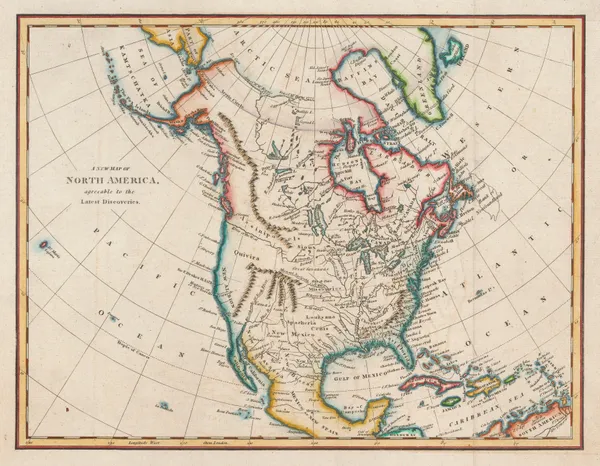
Thomas Kelly, North America, 1802£ 185.00
-
Matthew Carey, The State of Maryland, 1802£ 1,350.00
-
John Wilkes, Cornwall, 1802£ 115.00
-
Robert Wilkinson, The Ancient World According to Herodotus, 1802£ 175.00
-
Richard Phillips, London, 1802£ 795.00
-
John Wilkes, Derbyshire, 1802£ 145.00
-
Plan des Villes de Londres et Westminster et du Bourg de Southwark, 1802Bureau d'IndustrieSeries: WeimarBureau d'Industrie, Plan des Villes de Londres et Westminster et du Bourg de Southwark, 1802£ 795.00
-
-
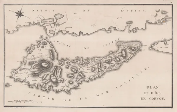
Pierre Tardieu, Corfu, 1802 c.£ 325.00
-
William Heather, Boulogne coast and environs, 1803£ 645.00
-
William Heather, Chart of the Andaman and Nicobar Islands, 1803£ 3,200.00
-
William Heather, Chart of the Azores, 1803£ 850.00
-
William Heather, Sea chart of the Bay of Bengal, 1803£ 2,250.00
-
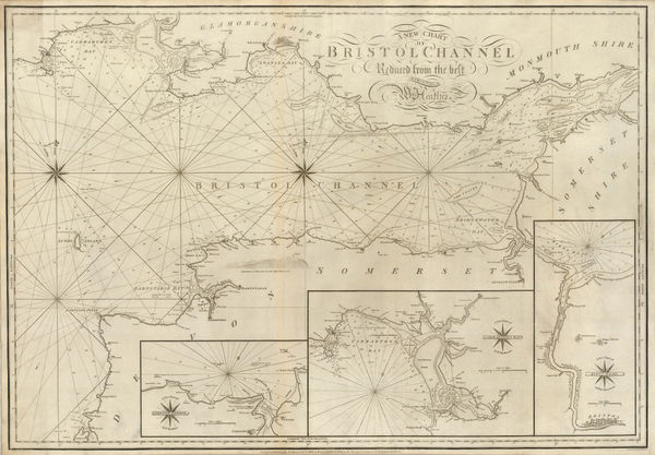
William Heather, A New Chart of the Bristol Channel, 1803£ 1,450.00


Page
50
of 130