-
 William Heather, Georgian chart of the Sunda Straits, 1803£ 1,950.00
 -
A New Chart Shewing the Navigation through the Sunda Straights to Batavia, 1803William HeatherSeries: LondonWilliam Heather, A New Chart Shewing the Navigation through the Sunda Straights to Batavia, 1803£ 2,950.00
-
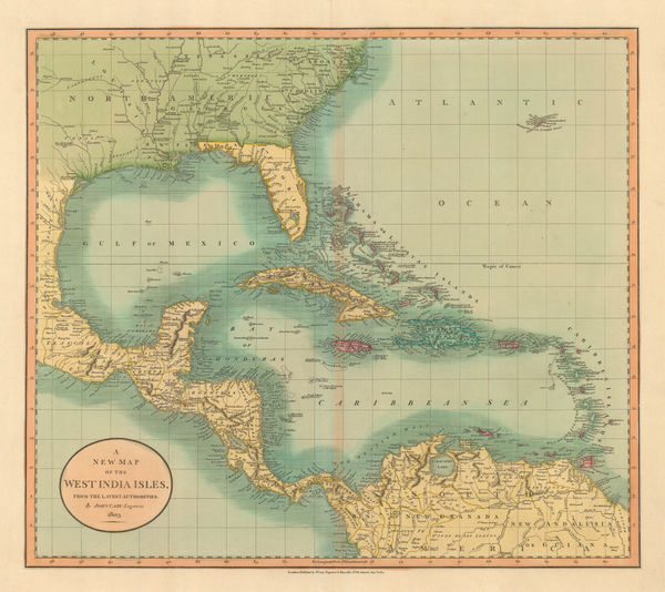
John Cary, West Indies and Southern United States, 1803£ 645.00
-
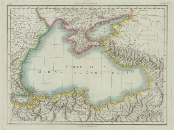
Pierre Tardieu, The Black Sea and Crimea, 1803£ 175.00
-
Johann Christoph Reinecke, Charte America, 1803£ 730.00
-
John Wilkes, Denmark, 1803£ 62.00
-
John Wilkes, Essex, 1803£ 95.00
-
William Faden, Chart of the Baltic Sea, 1803£ 1,150.00
-
John Cary, Map of England and Wales, 1803£ 485.00
-
Robert Orme, Pondicherry, 1803£ 265.00
-
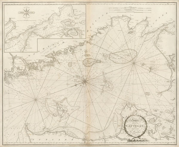
William Heather, Chart of the Kattegat, 1803£ 1,350.00
-
William Heather, Sea Chart of the Øresund & Copenhagen, 1803£ 1,850.00
-
Robert Wilkinson, Hannibal's Campaign, 1803£ 125.00
-
Jean-Baptiste Poirson, India, 1803£ 525.00
-
Rare French derivation of Aaron Arrowsmith's 1803 map of Ceylon (Sri Lanka), 1803 c.Aaron ArrowsmithSeries: FranceAaron Arrowsmith, Rare French derivation of Aaron Arrowsmith's 1803 map of Ceylon (Sri Lanka), 1803 c.£ 775.00
-
Charles Smith, A New Map of the County of Cornwall, 1804£ 395.00
-
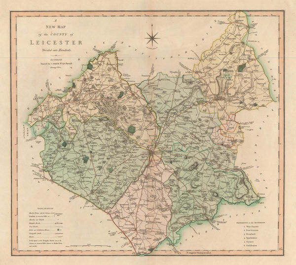
Charles Smith, A New Map of the County of Leicester, 1804£ 90.00
-
Charles Smith, A New Map of the County of Nottingham, 1804£ 150.00
-
John Cary, Belgium, 1804£ 145.00
-
Cole & Roper, Berkshire, 1804£ 88.00
-
Adolf Stieler, China divided into provinces, 1804£ 595.00
-
Christian Gottlieb Reichard, Chart of the North Pacific Ocean, 1804£ 785.00
-
Johann Christoph Reinecke, Australia and the Pacific Islands, 1804£ 885.00
-
Heather's New and Improved Chart of the Orkney Isles. Drawn from the Most Accurate Surveys., 1804William HeatherSeries: LondonWilliam Heather, Heather's New and Improved Chart of the Orkney Isles. Drawn from the Most Accurate Surveys., 1804£ 1,650.00
-
Johann Christoph Reinecke, Iceland, 1804£ 775.00
-
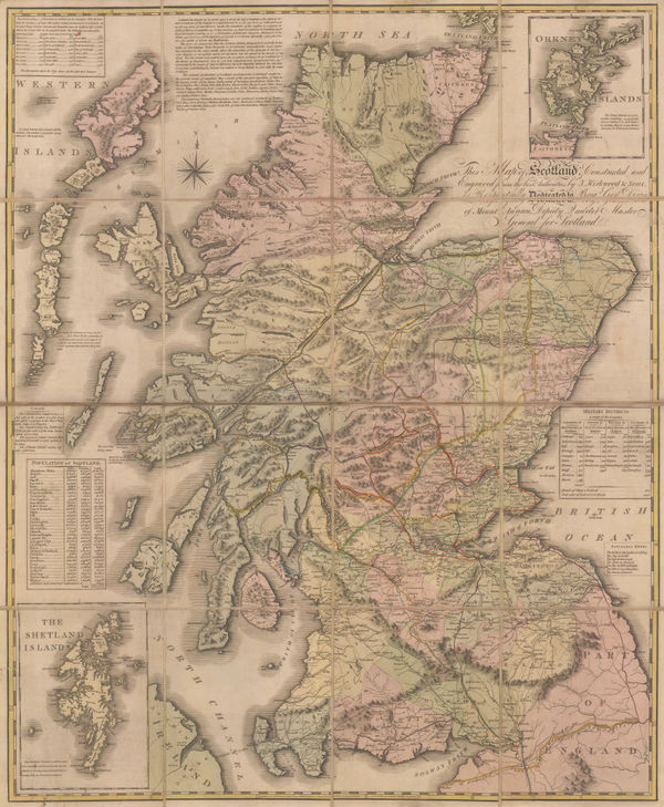
Kirkwood & Sons' Travelling Map of Scotland, 1804James Kirkwood & SonsSeries: Edinburgh, Perth & LondonJames Kirkwood & Sons, Kirkwood & Sons' Travelling Map of Scotland, 1804£ 975.00
-
-
Joseph Roux, Plan of Messina, 1804£ 95.00
-
-
William Heather, Sea Chart of the British Isles, 1804£ 1,850.00
-
-
-
-
-
Joseph Roux, Bay of Marseille, 1804£ 85.00
-
Joseph Roux, Chart of Palermo harbour, 1804£ 95.00
-
Mahmoud Raif Efendi, Rare Ottoman Map of the Channel Islands, 1804£ 2,200.00
-
Joseph Roux, [Toulon], 1804£ 85.00
-
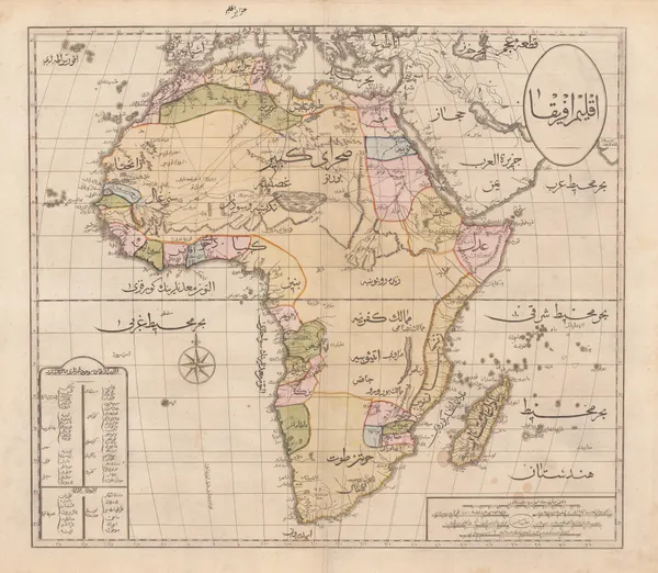
Robert Wilkinson, The Islamic World, 1804£ 985.00
-
Depot de la Guerre, Napoleonic Invasion Map of London, 1804£ 3,500.00
-
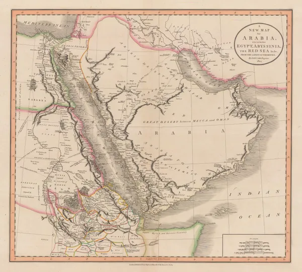
John Cary, A New Map of Arabia, including Egypt, Abyssinia, the Red Sea, &c., 1804£ 2,450.00
-
Charles Francois Delamarche, Amerique or Indes Occidentales, 1804 c.£ 1,250.00
-
John Cary, A Map of Essex from the Best Authorities, 1805£ 175.00
-
John Cary, A Map of South Wales, 1805£ 165.00
-
John Cary, A Map of the Island of Jersey, 1805£ 395.00
-
A Map of the Principal Roman Camps, Forts and Walls & c between the River Tyne in England and Tay in Scotland, 1805John CarySeries: LondonJohn Cary, A Map of the Principal Roman Camps, Forts and Walls & c between the River Tyne in England and Tay in Scotland, 1805£ 145.00
-
-
George & John Cary, Egypt and the Nile delta, 1805£ 365.00
-
John Cary, A New Map of Oxfordshire, 1805£ 425.00
-
Morse and Andrews, Asia, 1805£ 68.00
-
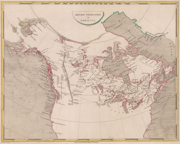
Thomas and Andrews, British Possessions in America, 1805£ 295.00
-
-
Johann Walch, German map of India and Southeast Asia, 1805£ 1,150.00
-
Cole & Roper, Cheshire, 1805£ 68.00
-
Morse and Andrews, China, 1805£ 225.00
-
Thomas and Andrews, Connecticut, 1805£ 265.00
-
Cole & Roper, Cumberland, 1805£ 78.00
-
Cole & Roper, Derbyshire, 1805£ 45.00
-
Cole & Roper, Durham, 1805£ 72.00
-
Laurie & Whittle, Nelson’s Victory at the Battle of Trafalgar, 1805£ 3,500.00
-
John Wilkes, France during the Napoleonic period, 1805£ 65.00
-
William Faden, General Chart of the Mediterranean Sea, 1805£ 2,250.00
-
Thomas and Andrews, Georgia, 1805£ 345.00
-
Cole & Roper, Gloucester, 1805£ 95.00
-
John Wilkes, Glocestershire, 1805£ 115.00
-
Charles Francois Delamarche, Wall map of Europe with Napoleon's conquests, 1805£ 3,950.00
-
John Cary, Map of Bedfordshire from the Best Authorities, 1805£ 145.00
-
John Cary, Map of Buckinghamshire from the Best Authorities, 1805£ 175.00
-
John Cary, Map of Cambridgeshire from the Best Authorities, 1805£ 155.00
-
John Cary, Map of Durham from the Best Authorities, 1805£ 160.00
-
Map of East Riding of Yorkshire with Ainsty Liberty from the Best Authorities, 1805John CarySeries: LondonJohn Cary, Map of East Riding of Yorkshire with Ainsty Liberty from the Best Authorities, 1805£ 195.00
-
John Cary, Map of Essex from the Best Authorities, 1805£ 295.00
-
John Cary, Map of Hertfordshire from the Best Authorities, 1805£ 245.00
-
John Cary, Map of Lancashire from the Best Authorities, 1805£ 275.00
-
John Cary, Map of Lincolnshire from the Best Authorities, 1805£ 225.00
-
John Cary, Map of Northamptonshire from the Best Authorities, 1805£ 225.00
-
John Cary, Map of Staffordshire from the Best Authorities, 1805£ 165.00
-
John Cary, Map of Suffolk from the Best Authorities, 1805£ 325.00
-
John Cary, Map of Surrey from the Best Authorities, 1805£ 375.00
-
John Cary, Map of Sussex from the Best Authorities, 1805£ 345.00


![Joseph Roux, [Toulon], 1804](https://static-assets.artlogic.net/w_600,c_limit,f_auto,fl_lossy,q_auto/artlogicstorage/themaphouse/images/view/82a0f77582740298dc8cc8514aa7032dj/themaphouse-joseph-roux-toulon-1804.jpg)


Page
51
of 130