-
 John Thomson, Fife & Kinross-Shire (West Sheet), 1827£ 325.00
 -
Charles Smith, Smith's New Map of the United Kingdom, 1827£ 3,750.00
-
Philippe Vandermaelen, Korea, 1827£ 795.00
-
Philippe Vandermaelen, Costa Rica & Nicaragua, 1827£ 445.00
-
John Walker, Thailand, Malaysia, Singapore, Vietnam, Laos and Cambodia., 1828£ 1,150.00
-
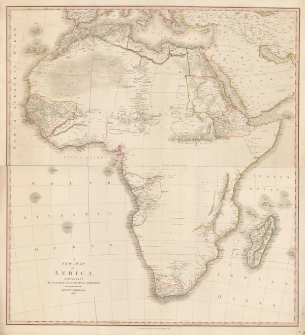
John Cary, A New Map of Africa exhibiting its Natural and Political Divisions, 1828£ 1,850.00
-
Carl Weiland, America, 1828£ 595.00
-
Samuel Arrowsmith, Asia, 1828£ 60.00
-
Adrien Brue, Spain and Portugal, 1828£ 95.00
-
George Frederick Cruchley, Cruchley's New Plan of London, 1828£ 800.00
-
C.V. Lavoisne, Geographical and Statistical Map of Italy, 1828£ 165.00
-
C.V. Lavoisne, Poland, Prussia, and Hungary, 1828£ 245.00
-
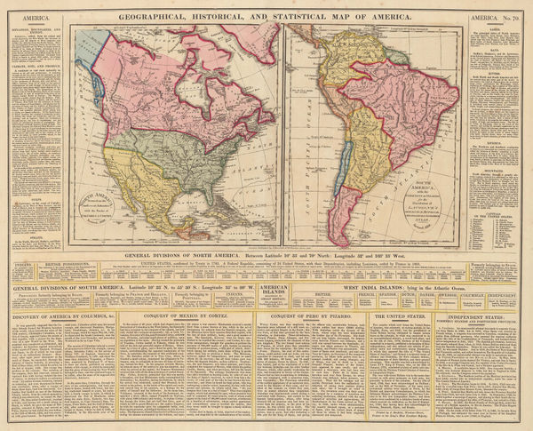
C.V. Lavoisne, Geographical, Historical, and Statistical Map of America, 1828£ 395.00
-
John Thomson, Haiti & the Dominican Republic, 1828£ 215.00
-
Carl Weiland, Iran, Afghanistan and Beludschistan, 1828£ 345.00
-
John Piggott-Smith, Brimingham, 1828£ 2,450.00
-
Map of North Africa Intended to Illustrate the Progress of Discovery in that Country, 1828Charles SmithSeries: LondonCharles Smith, Map of North Africa Intended to Illustrate the Progress of Discovery in that Country, 1828£ 495.00
-
John Thomson, Martinique and Dominica, 1828£ 195.00
-
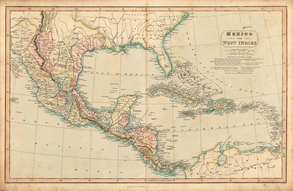
Charles Smith, Mexico and West Indies, 1828£ 345.00
-
John Thomson, Milanese States or Kingdom of Lombardy-Venetia, 1828£ 175.00
-
John Thomson, Southern Italy and Sicily, 1828£ 295.00
-
Justus Perthes, New South Wales, 1828£ 395.00
-
John Cary, New Sheet Map of Scotland from the Latest Authorities, 1828£ 425.00
-
John Thomson, Northern Balkans, 1828£ 145.00
-
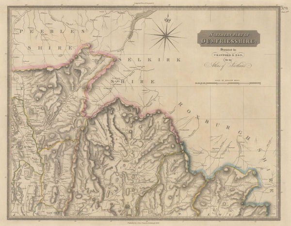
John Thomson, Dumfriesshire (Northeast Sheet), 1828£ 325.00
-
John Thomson, Dumfriesshire (Northwest Sheet), 1828£ 295.00
-
Baron Hyacinthe de Bougainville, Important plan of Port Jackson, 1828£ 3,450.00
-
John Thomson, Porto Rico and Virgin Islands & Haiti, Hispaniola or St.Domingo, 1828£ 345.00
-
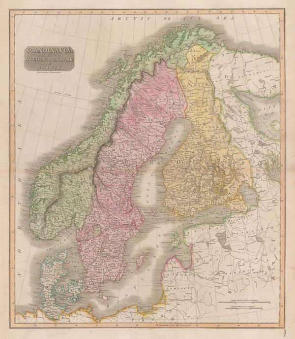
John Thomson, Scandinavia, 1828£ 175.00
-
J. Vincent, Ancient Scythia , 1828£ 64.00
-
John Crawfurd, Early map of Bangkok, 1828£ 445.00
-
John Thomson, Ayrshire (Southeast & Southwest Sheet), 1828£ 625.00
-
John Thomson, Dumfriesshire (Southwest Sheet), 1828£ 325.00
-
Sidney Hall, Switzerland, 1828£ 125.00
-
British Admiralty, Sea Chart of the coast of Mozambique, 1828£ 145.00
-
British Admiralty, Sea Chart of the coast of Mozambique, 1828£ 225.00
-
John Wilkes, The Balkans and Greece, 1828£ 195.00
-
John Wilkes, Warwickshire, 1828£ 75.00
-
John Wilkes, Wiltshire, 1828£ 88.00
-
John Wilkes, Worcestershire, 1828£ 82.00
-
John Thomson, Ayrshire (Northeast & Northwest Sheet), 1828£ 625.00
-
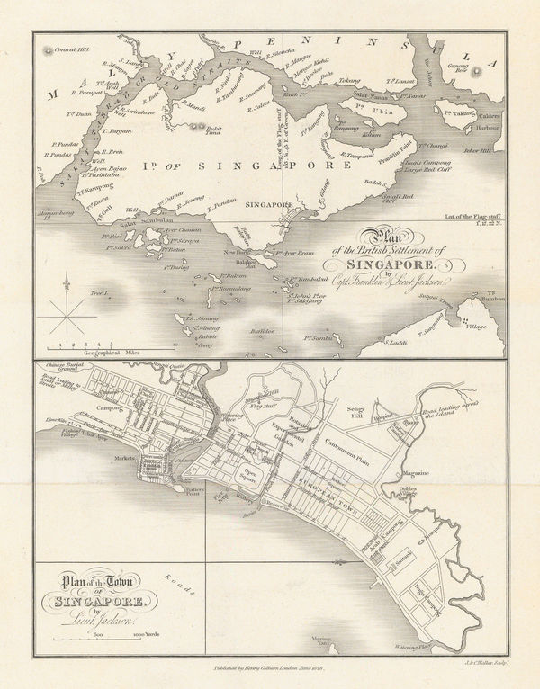
Philip Jackson, Plan of the British Settlement of Singapore, 1828£ 3,250.00
-
J. Vincent, Coast and Islands of the Aegean Sea, 1828£ 75.00
-
Glamorgan, Brecknockshire (Powys) and Radnorshire (Powys), 1828Christopher & John GreenwoodSeries: LondonChristopher & John Greenwood, Glamorgan, Brecknockshire (Powys) and Radnorshire (Powys), 1828£ 1,250.00
-
John Thomson, New South Wales and Tasmania, 1828£ 1,250.00
-
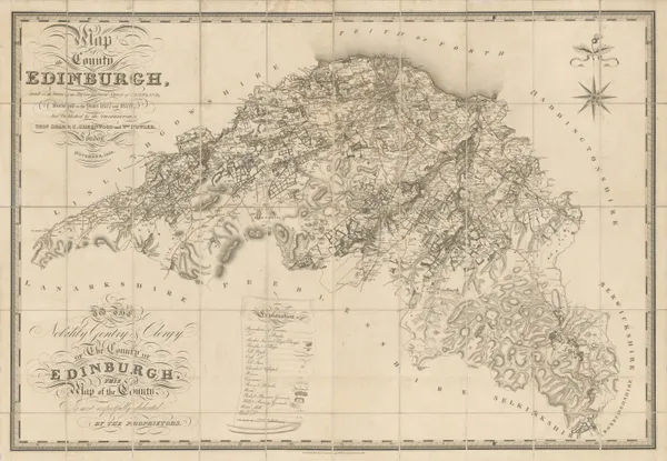
Christopher & John Greenwood, Edinburgh, 1828£ 2,250.00
-
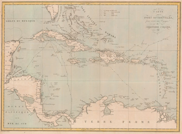
Pierre Tardieu, The Voyages of Christopher Columbus, 1828£ 950.00
-
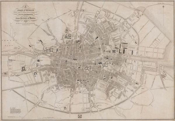
James Kirkwood & Sons, A Plan of Dublin with the latest Improvements, 1828£ 950.00
-
Henry Teesdale, Wall Map of Yorkshire, 1828£ 2,750.00
-
Adrien Brue, Southern Africa & the Cape Colony, 1828 c.£ 250.00
-
John Crawfurd, Myanmar, John Crawfurd's journey to the Court of the King of Burma, 1829Reserved
-
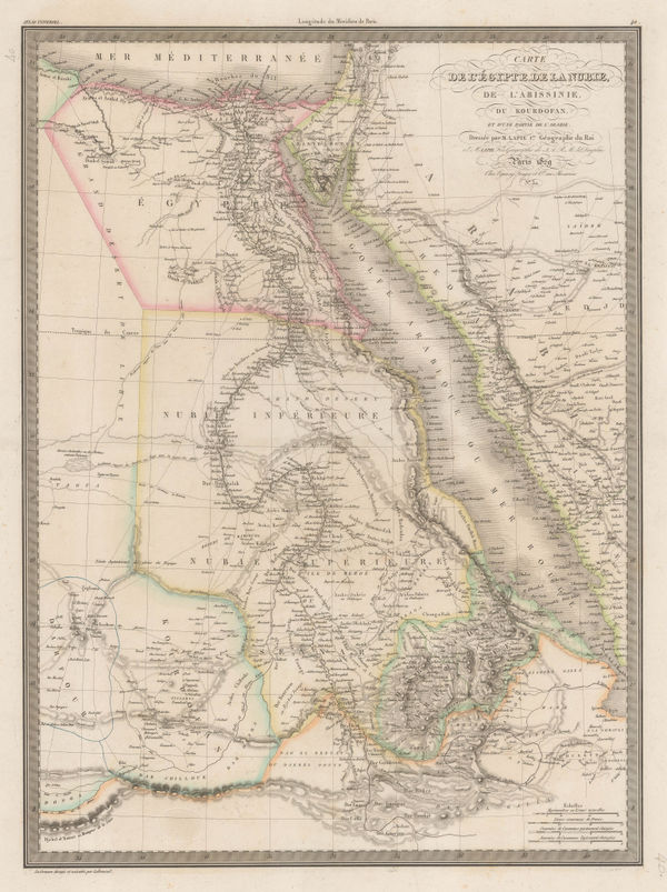
Egypt, the Nile Valley, Sudan, Eritrea, and parts of Ethiopia, 1829Alexandre Emile LapieSeries: ParisAlexandre Emile Lapie, Egypt, the Nile Valley, Sudan, Eritrea, and parts of Ethiopia, 1829£ 140.00
-
Alexandre Emile Lapie, Australia, New Zealand and the South Pacific, 1829£ 175.00
-
Christopher & John Greenwood, Map of the County of Berks., 1829£ 650.00
-
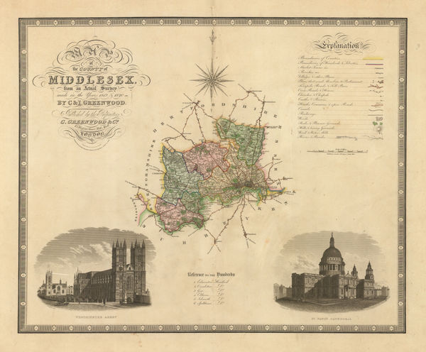
Christopher & John Greenwood, Map of the County of Middlesex, 1829£ 475.00
-
Christopher & John Greenwood, Map of the County of Surrey, 1829£ 525.00
-
Christopher & John Greenwood, Map of the County of Sussex, 1829£ 850.00
-
Andrew Bryant, Map of the East Riding of Yorkshire from Actual Survey, 1829£ 2,750.00
-
Frederick Trench, Westminster, the Strand, and the Southbank, 1829£ 275.00
-
Christopher & John Greenwood, Map of the County of Cornwall, 1829£ 975.00
-
Christopher & John Greenwood, Map of the County of Wiltshire, 1829£ 745.00
-
Aaron Arrowsmith, Hindoostan, 1829£ 125.00
-
Christopher & John Greenwood, Hampshire, 1829£ 695.00
-
Christopher & John Greenwood, Map of the County of Somerset from an Actual Survey, 1829£ 725.00
-
Henry Fisher, South America, 1829£ 115.00
-
A Map of the County of Northampton from an Actual Survey, 1830Christopher & John GreenwoodSeries: LondonChristopher & John Greenwood, A Map of the County of Northampton from an Actual Survey, 1830£ 395.00
-
George Hennet, A Map of the County Palatine of Lancaster, 1830£ 2,250.00
-
Carl Weiland, Australia and the Pacific Ocean, 1830£ 875.00
-
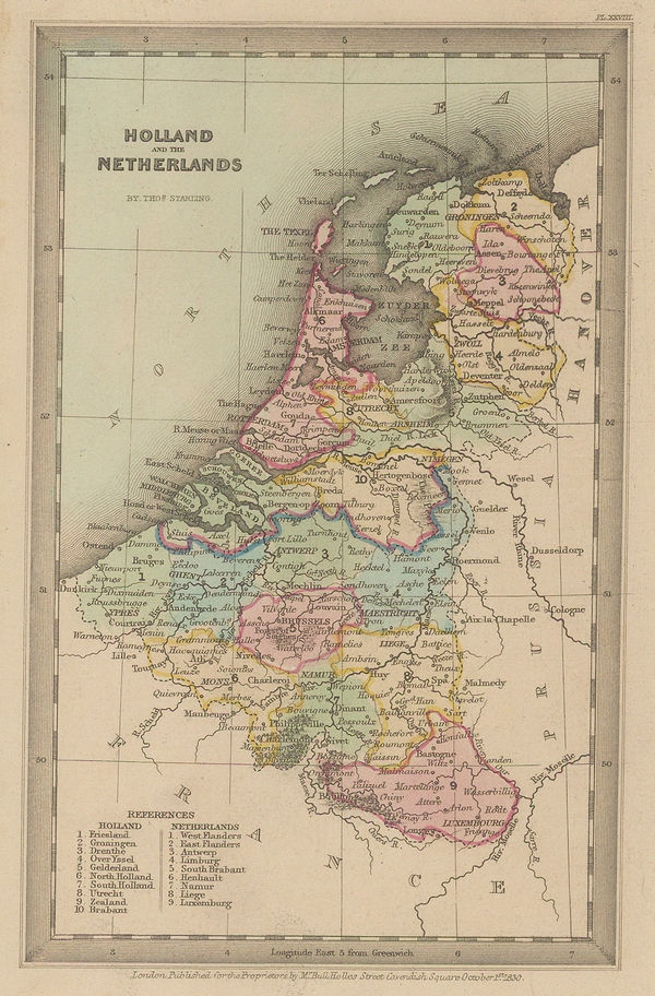
Thomas Starling, Netherlands, Belgium and Luxembourg, 1830£ 80.00
-
John Murray, Lincolnshire, 1830£ 85.00
-
Map of the County of Cumberland from an Actual Survey, 1830Christopher & John GreenwoodSeries: LondonChristopher & John Greenwood, Map of the County of Cumberland from an Actual Survey, 1830£ 350.00
-
Christopher & John Greenwood, Map of the County of Leicester, 1830£ 495.00
-
Christopher & John Greenwood, Map of the County of Stafford, 1830£ 385.00
-
Christopher & John Greenwood, Map of the County of Warwick, 1830£ 450.00
-
Christopher & John Greenwood, Map of the County of Westmoreland, 1830£ 395.00
-
Christopher & John Greenwood, Map of the County of Worcester, 1830£ 450.00
-
Christopher & John Greenwood, Map of the County Palatine of Chester, 1830£ 485.00
-
Christopher & John Greenwood, Map of the County Palatine of Lancashire, 1830£ 685.00
-
John Thomson, Nairn and Elgin, 1830£ 395.00
-
John Thomson, Inverness-shire, 1830£ 1,200.00


Page
61
of 130