-
 Thomas Moule, Staffordshire, 1840 c.£ 115.00
 -
Thomas Moule, Surrey, 1840 c.£ 245.00
-
James Pigot, Sussex, 1840 c.£ 185.00
-
W. & A.K. Johnston, Sweden & Norway, 1840 c.£ 125.00
-
Thomas Kelly, Sweden & Norway, 1840 c.£ 95.00
-
Daniel & William Lizars, Switzerland, 1840 c.£ 70.00
-
Charles V. Monin, Tableau Comparatif de la Hauteur des Montagnes, 1840 c.£ 475.00
-
Thomas Moule, Warwickshire, 1840 c.£ 165.00
-
Samuel Lewis, Warwickshire, 1840 c.£ 35.00
-
Royal Geographical Society (RGS), West Coast of Africa, 1840 c.£ 125.00
-
W. & A.K. Johnston, West Indies, 1840 c.£ 395.00
-
John Dower, West Indies, 1840 c.£ 72.00
-
James Pigot, Westmoreland, 1840 c.£ 88.00
-
Thomas Moule, Westmoreland, 1840 c.£ 55.00
-
James Pigot, Wiltshire, 1840 c.£ 115.00
-
Cole & Roper, Worcestershire, 1840 c.£ 92.00
-
Thomas Moule, Yorkshire East Riding, 1840 c.£ 92.00
-
John Tallis, [Blackfriars Rd], 1840 c.£ 80.00
-
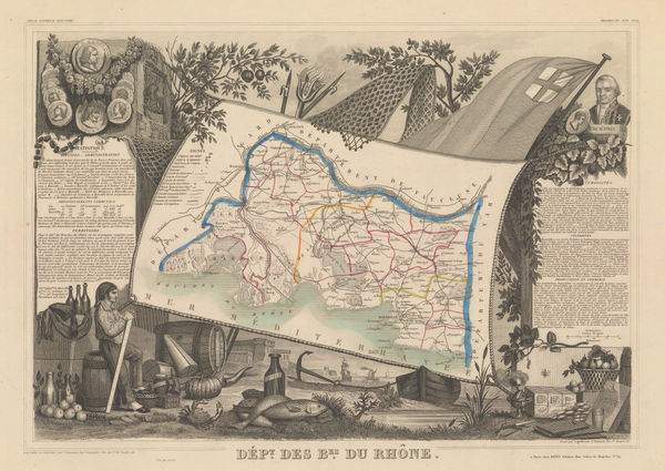
Victor Levasseur, Bouches-du-Rhône, 1840 c.£ 60.00
-
Thomas Moule, Sussex, 1840 c.£ 345.00
-
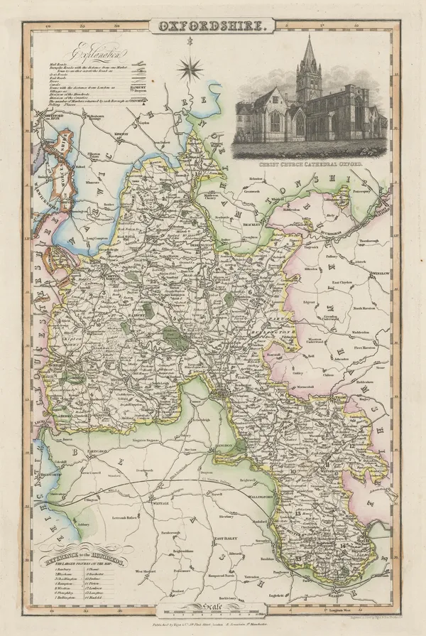
James Pigot, Oxfordshire, 1840 c.£ 195.00
-
Thomas Moule, Essex, 1840 c.£ 115.00
-
Thomas Moule, Northamptonshire, 1840 c.£ 145.00
-
Samuel Lewis, A Plan of London and its Environs, 1840 c.£ 750.00
-
Thomas Moule, Cumberland, 1840 c.£ 85.00
-
Thomas Moule, Cheshire, 1840 c.£ 110.00
-
Thomas Moule, Cambridge, 1840 c.£ 245.00
-
Thomas Moule, Oxford, 1840 c.£ 285.00
-
Henry Teesdale, China and Japan, 1841£ 395.00
-
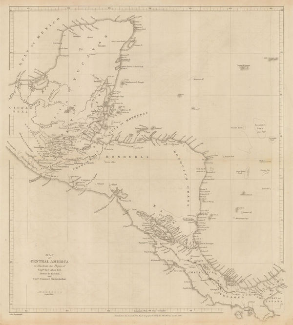
Royal Geographical Society (RGS), Central America, 1841£ 385.00
-
John Walker, Map of the Countries on the North West Frontier of India, 1841£ 4,850.00
-
John Arrowsmith, Map of the West Coast of Africa, 1841£ 1,450.00
-
James Wyld, The West Indies, 1841£ 1,375.00
-
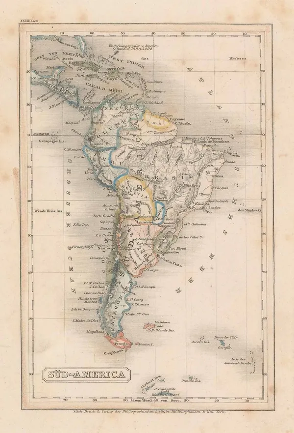
Carl Christian Franz Radefeld, Miniature map of South America, 1841£ 50.00
-
The Caspian Sea with parts of Kazakhstan, Uzbekistan & Turkmenistan, 1841John ArrowsmithSeries: LondonJohn Arrowsmith, The Caspian Sea with parts of Kazakhstan, Uzbekistan & Turkmenistan, 1841£ 765.00
-
James Wyld, The United States of North America with the British Territories, 1841£ 1,850.00
-
Carl Christian Franz Radefeld, West Indies, 1841£ 45.00
-
-
Henry Teesdale, Arabia, Iran (Persia) and Afghanistan (Caubul), 1841£ 375.00
-
-
W. & A.K. Johnston, Johnston's County Map of Lanarkshire, 1841£ 850.00
-
James Wyld, Plan of London and Westminster, 1841£ 2,000.00
-
Society for the Diffusion of Useful Knowledge (SDUK), Geneva, 1841£ 225.00
-
Ordnance Survey, The Peak District, 1841 (c.)£ 150.00
-
Thomas Moule, Portsmouth, 1841 c.£ 88.00
-
John Arrowsmith, Asia, 1842£ 245.00
-
John Arrowsmith, Asia Minor or Turkey, 1842£ 445.00
-
J. Blumethal, Asia, 1842£ 70.00
-
John Arrowsmith, Austrian Empire, 1842£ 425.00
-
John Arrowsmith, Cape of Good Hope, 1842£ 850.00
-
John Arrowsmith, Cape of Good Hope, 1842£ 68.00
-
Benedetto Marzolla, Carta Generale dell'Antartica, 1842£ 1,450.00
-
-
John Arrowsmith, Egypt, 1842£ 185.00
-
Royal Geographical Society (RGS), Frobisher Strait & Northumberland Inlet, 1842£ 145.00
-
John Arrowsmith, Ireland, 1842£ 345.00
-
James Wyld, Lower Egypt or the Nile Delta, 1842£ 285.00
-
Map of Afghaunistan, Caubul, The Punjab, Rajpootana and the River Indus, 1842James WyldSeries: LondonJames Wyld, Map of Afghaunistan, Caubul, The Punjab, Rajpootana and the River Indus, 1842£ 1,950.00
-
James Wyld, North and South America with Pacific Ocean, 1842£ 750.00
-
J. & C. Walker, Map of the British Isles, 1842£ 1,450.00
-
John Arrowsmith, Windward Isles, 1842£ 495.00
-
Thomas Kelly, Mexico & Central America, 1842£ 150.00
-
Daniel Veelward, The Discovery of America, 1842£ 350.00
-
John Arrowsmith, Pacific Ocean, 1842£ 185.00
-
Forrester & Ruthven, Bath, 1842£ 58.00
-
John Arrowsmith, Russia in Europe, 1842£ 52.00
-
Sketch of the Acquisitions of Russia since the Accession of Peter 1st to the Throne, 1842John ArrowsmithSeries: LondonJohn Arrowsmith, Sketch of the Acquisitions of Russia since the Accession of Peter 1st to the Throne, 1842£ 495.00
-
Royal Geographical Society (RGS), Sketch of The Kuria-Muria Islands., 1842£ 68.00
-
John Arrowsmith, South America, 1842£ 62.00
-
James Wyld, South America, 1842£ 94.00
-
John Arrowsmith, Spain & Portugal, 1842£ 125.00
-
Topographical Survey of the Plain of Troy with the Ancient Sites, 1842Royal Geographical Society (RGS)Series: LondonRoyal Geographical Society (RGS), Topographical Survey of the Plain of Troy with the Ancient Sites, 1842£ 380.00
-
John Arrowsmith, Greece and the Balkans, 1842£ 245.00
-
John Arrowsmith, Victorian map of the Eastern United States, 1842£ 595.00
-
John Arrowsmith, Detailed map of Tasmania, 1842£ 575.00
-
John Arrowsmith, West Indies, 1842£ 60.00
-
Society for the Diffusion of Useful Knowledge (SDUK), Boston, 1842£ 695.00
-
Samuel Lewis, Lancashire, 1842£ 75.00
-
Samuel Lewis, Devon, 1842£ 85.00
-
Samuel Lewis, Gloucestershire, 1842£ 75.00


![John Tallis, [Blackfriars Rd], 1840 c.](https://static-assets.artlogic.net/w_600,c_limit,f_auto,fl_lossy,q_auto/artlogicstorage/themaphouse/images/view/3b1bd440ddfe2ce5d75946d0c0776cbcj/themaphouse-john-tallis-blackfriars-rd-1840-c..jpg)


Page
67
of 130