-
 Royal Geographical Society (RGS), Sketch of Routes in Kachhi Gandava, 1844£ 76.00
 -
Royal Geographical Society (RGS), Southern Somalia, 1844£ 78.00
-
Royal Geographical Society (RGS), The Cross River, Nigeria, 1844£ 48.00
-
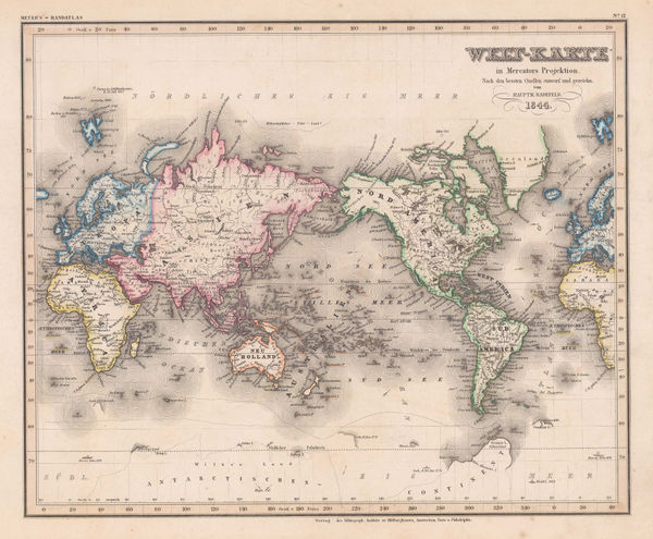
Joseph Meyer, Welt-Karte in Mercators Projektion, 1844£ 275.00
-
Joseph Meyer, West African coast, 1844£ 145.00
-
Bellerby & Sampson, York, 1844£ 295.00
-
Society for the Diffusion of Useful Knowledge (SDUK), Madrid, 1844£ 295.00
-
Virginia, Maryland, Delaware, Pennsylvania & New Jersey, 1844Society for the Diffusion of Useful Knowledge (SDUK)Series: LondonSociety for the Diffusion of Useful Knowledge (SDUK), Virginia, Maryland, Delaware, Pennsylvania & New Jersey, 1844£ 145.00
-
Society for the Diffusion of Useful Knowledge (SDUK), New England, 1844£ 145.00
-
Joseph Meyer, Munich, 1844£ 495.00
-
Royal Geographical Society (RGS), Northern Tablelands, New South Wales, 1844£ 175.00
-
Edward Mogg, London in Miniature with Surrounding Villages, 1844£ 1,850.00
-
Society for the Diffusion of Useful Knowledge (SDUK), Warsaw, 1844£ 395.00
-
Society for the Diffusion of Useful Knowledge (SDUK), New South Wales, 1844£ 395.00
-
Society for the Diffusion of Useful Knowledge (SDUK), Lisbon, 1844£ 495.00
-
Joseph Meyer, Europaeisches Russland, 1844£ 185.00
-
William Houghton Allen & Co., The Punjab, Pakistan & Afghanistan, 1844£ 950.00
-
Society for the Diffusion of Useful Knowledge (SDUK), Marseille, 1844£ 98.00
-
Society for the Diffusion of Useful Knowledge (SDUK), Ancient Athens, 1844£ 325.00
-
Society for the Diffusion of Useful Knowledge (SDUK), Moscow, 1844£ 595.00
-
Society for the Diffusion of Useful Knowledge (SDUK), Porto, 1844£ 475.00
-
Society for the Diffusion of Useful Knowledge (SDUK), St. Petersburg, 1844£ 325.00
-
Society for the Diffusion of Useful Knowledge (SDUK), Stockholm, 1844£ 375.00
-
Society for the Diffusion of Useful Knowledge (SDUK), Copenhagen, 1844£ 325.00
-
Society for the Diffusion of Useful Knowledge (SDUK), Ancient Rome, 1844£ 325.00
-
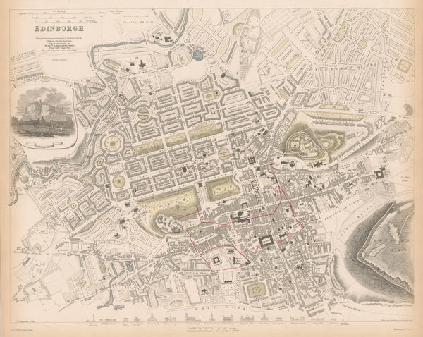
Society for the Diffusion of Useful Knowledge (SDUK), Edinburgh, 1844£ 445.00
-
Society for the Diffusion of Useful Knowledge (SDUK), Australia in 1839, 1844£ 525.00
-
Society for the Diffusion of Useful Knowledge (SDUK), Amsterdam, 1844£ 295.00
-
Society for the Diffusion of Useful Knowledge (SDUK), Florence, 1844£ 425.00
-
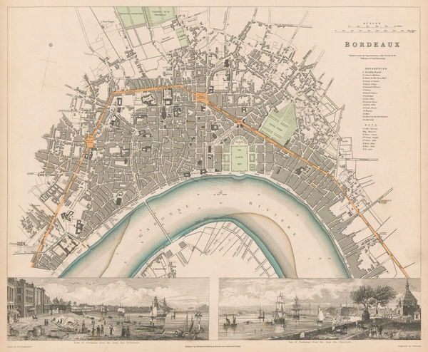
Society for the Diffusion of Useful Knowledge (SDUK), Bordeaux, 1844£ 195.00
-
Society for the Diffusion of Useful Knowledge (SDUK), Philadelphia, 1844£ 495.00
-
A Map of the Principal Rivers shewing their Courses, Countries, and Comparative Lengths, 1844Society for the Diffusion of Useful Knowledge (SDUK)Series: LondonSociety for the Diffusion of Useful Knowledge (SDUK), A Map of the Principal Rivers shewing their Courses, Countries, and Comparative Lengths, 1844£ 195.00
-
Society for the Diffusion of Useful Knowledge (SDUK), The Pacific Ocean, 1844£ 95.00
-
Society for the Diffusion of Useful Knowledge (SDUK), Chile & Argentina, 1844£ 145.00
-
Joseph Meyer, Brussels (Bruxelles), 1844 c.£ 325.00
-
James Wyld, The Kingdom of France, 1844 c.£ 295.00
-
-
Joseph Meyer, Antwerp, 1845£ 275.00
-
Joseph Meyer, Asiatic Russia, 1845£ 135.00
-
J. & C. Walker, Bedfordshire, 1845£ 68.00
-
Henry Teesdale, Canada, New Brunswick and Nova Scotia, 1845£ 185.00
-
General Land Office (GLO), Diagram of the State of Illinois, 1845£ 120.00
-
Royal Geographical Society (RGS), Australia and South-East Asia, 1845£ 345.00
-
Joseph Meyer, Frankfurt, 1845£ 485.00
-
Hansard, Eton - Frogmore Estate, 1845£ 295.00
-
Reuben Ramble, Herefordshire, 1845£ 65.00
-
J. & C. Walker, Herefordshire, 1845£ 58.00
-
J. & C. Walker, Lincolnshire, 1845£ 68.00
-
Ashford & Loader, Map and Sections of the Staffordshire Coal Field, 1845£ 125.00
-
Map of an Exploring Expedition to the Rocky Mountains in the Year 1842 and to Oregon & North California in the Years 1845-44, 1845John C. FremontSeries: Washington, D.C.John C. Fremont, Map of an Exploring Expedition to the Rocky Mountains in the Year 1842 and to Oregon & North California in the Years 1845-44, 1845£ 3,950.00
-
Map of the Railways Showing the Various Stations with the Hills, Rivers, Canals and Principal Roads of England and Wales, 1845Aaron ArrowsmithSeries: LondonAaron Arrowsmith, Map of the Railways Showing the Various Stations with the Hills, Rivers, Canals and Principal Roads of England and Wales, 1845£ 2,450.00
-
General Land Office (GLO), Map of the State of Florida, 1845£ 725.00
-
William Colling Hobson, Map of Yorkshire, 1845£ 845.00
-
J. & C. Walker, Monmouthshire, 1845£ 44.00
-
Joseph Meyer, Naples, 1845£ 495.00
-
Joseph Meyer, Kentucky, 1845£ 275.00
-
Joseph Meyer, Coastal countries of the Black Sea, 1845£ 145.00
-
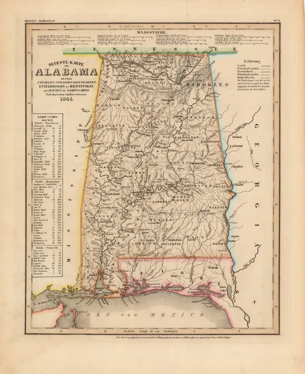
Joseph Meyer, Alabama, 1845£ 265.00
-
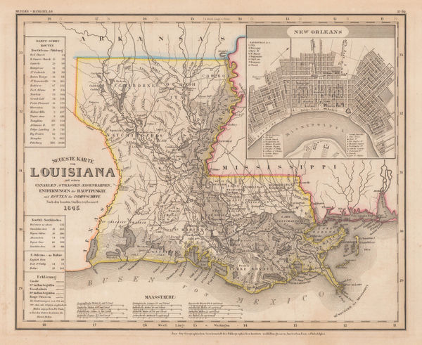
Joseph Meyer, Louisiana and New Orleans, 1845£ 325.00
-
Joseph Meyer, Maine, 1845£ 255.00
-
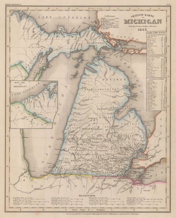
Joseph Meyer, Michigan, 1845£ 345.00
-
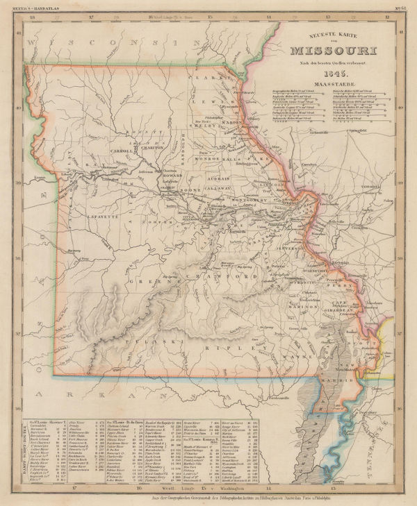
Joseph Meyer, Missouri, 1845£ 160.00
-
Joseph Meyer, German map of Ohio, 1845£ 245.00
-
Joseph Meyer, Pennsylvania, 1845£ 275.00
-
Isaac Slater, Ireland with railways and canals, 1845£ 825.00
-
George Frederick Cruchley, North America, 1845£ 120.00
-
Royal Geographical Society (RGS), The Grijalva River, 1845£ 85.00
-
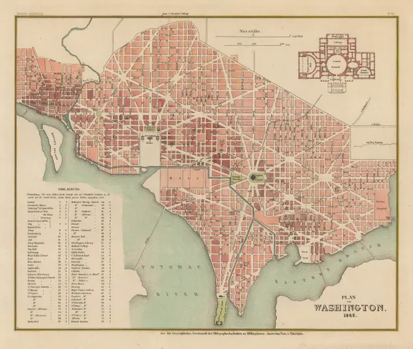
Joseph Meyer, Street plan of Washington D. C., 1845£ 745.00
-
James Wyld, Post Map of Europe, 1845£ 450.00
-
James Wyld, Railway Map of England Wales and Scotland, 1845£ 1,850.00
-
General Land Office (GLO), Sketch of the Public Surveys of Michigan, 1845£ 155.00
-
George Frederick Cruchley, South America, 1845£ 85.00
-
Henry Teesdale, Spain & Portugal, 1845£ 75.00
-
Ashford & Loader, The Heights of the Mountains of the Eastern Hemisphere, 1845£ 975.00
-
Royal Geographical Society (RGS), The Ural Mountains, 1845£ 345.00
-
George Frederick Cruchley, United States, 1845£ 140.00
-
J. & C. Walker, Westmorland, 1845£ 62.00
-
Joseph Meyer, Illinois, 1845£ 325.00
-
Henry Teesdale, Egypt, 1845£ 145.00
-
Isaac Slater, Lincolnshire, 1845£ 145.00


Page
69
of 130