-
 Royal Geographical Society (RGS), Southern Iraq and Iranian border, 1856£ 145.00
 -
Royal Geographical Society (RGS), Southern Central Africa, 1856£ 225.00
-
David H. Burr, Map Showing the Surveys in the Territory of Utah, 1856£ 1,550.00
-
Map to illustrate A Visit to Moselekatse, King of the Matebele, 1856Royal Geographical Society (RGS)Series: LondonRoyal Geographical Society (RGS), Map to illustrate A Visit to Moselekatse, King of the Matebele, 1856£ 145.00
-
Royal Geographical Society (RGS), Western Australia from Shark Bay to Perth, 1856£ 85.00
-
George Philip, Martinique & Dominica, 1856£ 140.00
-
Lallemand, Tourist map of Paris, 1856£ 445.00
-
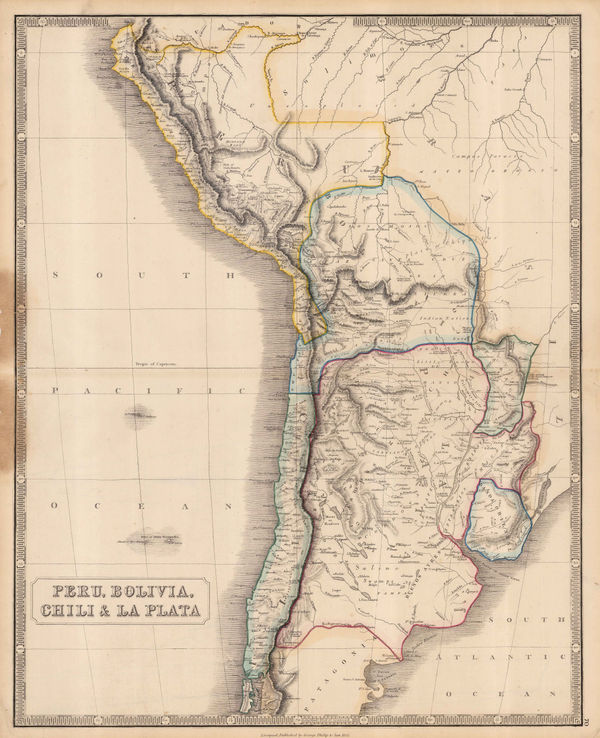
George Philip & Son Ltd., Peru, Bolivia, Chili & La Plata, 1856£ 295.00
-
Jean Andriveau-Goujon, Plan of Paris, 1856£ 695.00
-
George Philip, Russia in Europe, 1856£ 185.00
-
Thailand (Siam) and the Chao Phraya (Menam) River, 1856Royal Geographical Society (RGS)Series: LondonRoyal Geographical Society (RGS), Thailand (Siam) and the Chao Phraya (Menam) River, 1856£ 245.00
-
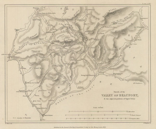
Royal Geographical Society (RGS), Valley of Beaufort and parts of Upper Savoy, 1856£ 175.00
-
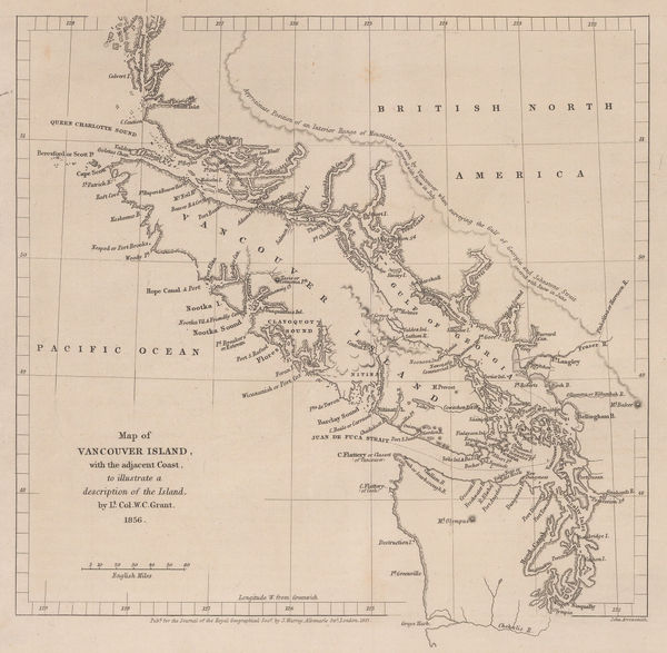
Royal Geographical Society (RGS), Southern coast of Vancouver Island, 1856£ 195.00
-
Justus Perthes, Kenya and Tanzania, 1856£ 595.00
-
Royal Geographical Society (RGS), The Mythical Sea of Uniamesi &c., 1856£ 295.00
-
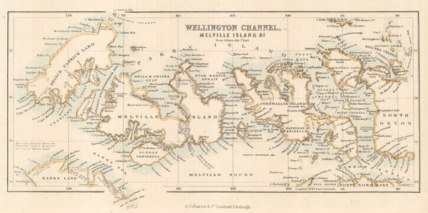
Archibald Fullarton, Wellington Channel, Melville Island &c., 1856£ 82.00
-
-
Justus Perthes, Natal Colony, 1856£ 88.00
-
Edward Quin, A.D. 476. The Dissolution of the Western Empire, 1856 c.£ 125.00
-
Morse & Gaston, Arkansas, 1857£ 32.00
-
Carl & Adolf Graf, Australasia, 1857£ 325.00
-
Carl Flemming, California, Oregon, Utah and New Mexico, 1857£ 395.00
-
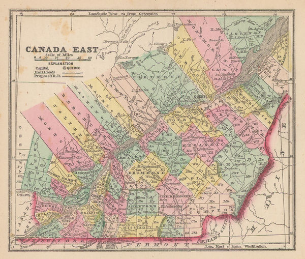
Morse & Gaston, Quebec Province, 1857£ 32.00
-
Auguste-Henri Dufour, Iberian peninsula with border of Spanish cities, 1857£ 2,450.00
-
Morse & Gaston, Connecticut, Rhode Island, and Long Island, 1857£ 38.00
-
Royal Geographical Society (RGS), Isthmus of Panama, 1857£ 225.00
-
Justus Perthes, Brazil - Bolivia border, 1857£ 175.00
-
Morse & Gaston, Kentucky and Tennessee, 1857£ 36.00
-
Letts & Son, London and its Environs, 1857£ 925.00
-
Morse & Gaston, Maine, 1857£ 36.00
-
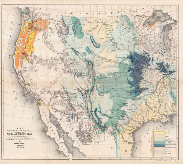
Map Illustrating the General Geological features of the Country West of the Mississippi River, 1857James HallSeries: Washington, D.C.James Hall, Map Illustrating the General Geological features of the Country West of the Mississippi River, 1857£ 1,350.00
-
Royal Geographical Society (RGS), Myanmar (Burma), 1857£ 495.00
-
Hansard, Railway and Cotton District Map of India, 1857£ 950.00
-
Map of the State of Florida Showing the Progress of the Surveys, 1857General Land Office (GLO)Series: PhiladelphiaGeneral Land Office (GLO), Map of the State of Florida Showing the Progress of the Surveys, 1857£ 425.00
-
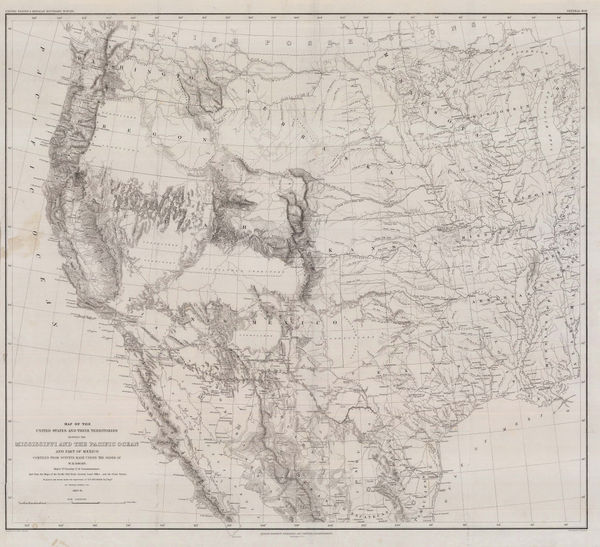
Map of the Unites States and their Territories between the Mississippi and the Pacific Ocean, 1857William Hemsley EmorySeries: Washington, D.C.William Hemsley Emory, Map of the Unites States and their Territories between the Mississippi and the Pacific Ocean, 1857£ 850.00
-
Royal Geographical Society (RGS), Vancouver Island and coast of British Columbia, 1857£ 485.00
-
Map to Illustrate Notes on Routes from Bushire to Shiraz by Lt. Genl. Monteith and from Shiraz to Darab & thence to Kazerin by Consul Keith E.Abbott, 1857Royal Geographical Society (RGS)Series: LondonRoyal Geographical Society (RGS), Map to Illustrate Notes on Routes from Bushire to Shiraz by Lt. Genl. Monteith and from Shiraz to Darab & thence to Kazerin by Consul Keith E.Abbott, 1857£ 98.00
-
Alexander Dallas Bache, St. Mary's River and Fernandina Harbour, 1857£ 275.00
-
Morse & Gaston, Vermont & New Hampshire, 1857£ 36.00
-
Morse & Gaston, Wisconsin, 1857£ 32.00
-
George Frederick Cruchley, India during the Mutinies, 1857£ 3,750.00
-
Joseph Hutchins Colton, Map of New York with Adjacent Cities, 1857£ 825.00
-
Adrian J. Bogaerts, Wall Map of the Dutch East Indies (Indonesia), 1857£ 2,850.00
-
Justus Perthes, Malacca Province, 1857£ 72.00
-
Justus Perthes, Uruguay, 1857£ 115.00
-
Justus Perthes, Lake Baikal, 1857£ 125.00
-
George Woolworth Colton, Kansas and Nebraska, 1857 c.£ 185.00
-
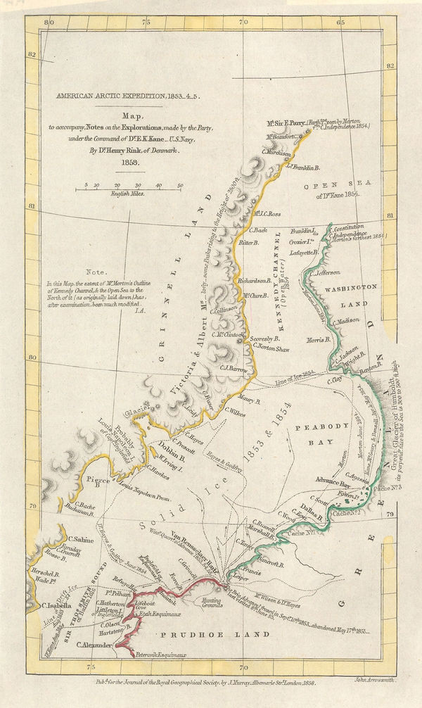
Royal Geographical Society (RGS), American Arctic Expedition, 1853_4_5, 1858£ 185.00
-
Samuel Lewis, Cardiganshire, 1858£ 32.00
-
Samuel Lewis, Carnarvonshire, 1858£ 32.00
-
Der Warme Meeresstrom des Atlantischen und Der Kalte Strom des Grossen Oceans, 1858Carl Christian Franz RadefeldSeries: HildburghausenCarl Christian Franz Radefeld, Der Warme Meeresstrom des Atlantischen und Der Kalte Strom des Grossen Oceans, 1858£ 88.00
-
Samuel Lewis, Flintshire, 1858£ 28.00
-
Robert William Mylne, Geological and Topographical Map of London & its Environs, 1858£ 2,500.00
-
Samuel Lewis, Herefordshire, 1858£ 35.00
-
Justus Perthes, Sketch map of northern Senegal, 1858£ 68.00
-
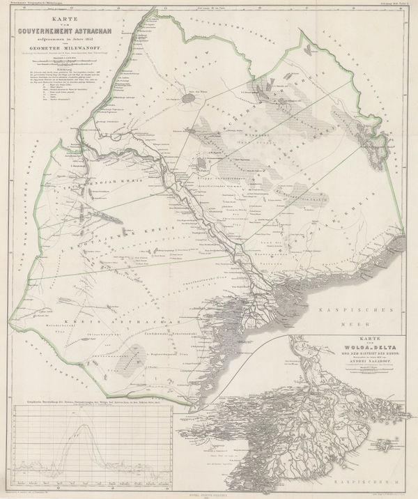
Justus Perthes, Astrakhan & Volga River delta, 1858£ 295.00
-
Royal Geographical Society (RGS), Map of the Amur and Adjacent Districts, 1858£ 225.00
-
A.C. Gregory's North Australian Exploring Expedition, 1858Royal Geographical Society (RGS)Series: LondonRoyal Geographical Society (RGS), A.C. Gregory's North Australian Exploring Expedition, 1858£ 675.00
-
W. Saunders, Brighton, 1858£ 1,450.00
-
J.A. Sala, Plan of Barcelona, 1858£ 1,450.00
-
Joseph Christmas Ives, Rio Colorado of the West, 1858£ 1,250.00
-
Joseph Christmas Ives, Rio Colorado of the West, 1858£ 1,250.00
-
Samuel Lewis, Rutlandshire, 1858£ 22.00
-
Royal Geographical Society (RGS), South Africa, 1858£ 145.00
-
Justus Perthes, Great Salt Lake and Utah Lake, 1858£ 88.00
-
John Arrowsmith, South America, 1858£ 1,650.00
-
Justus Perthes, Korea & Manchuria, 1858£ 145.00
-
Joseph Hutchins Colton, Middle East, 1858£ 245.00
-
Justus Perthes, The Moon - Three Views of the Sea of Crises, 1858£ 225.00
-
Alexander Keith Johnston, New South Wales and Victoria, 1858 c.£ 495.00
-
Royal Geographical Society (RGS), Portuguese Exploration in Central Africa, 1859£ 385.00
-
Royal Geographical Society (RGS), Burton & Speke's exploratory route in Tanzania, 1859£ 195.00
-
F.A. Brockhaus, Decorative map of Europe, 1859£ 485.00
-
Justus Perthes, European Russia, Scandinavia and Central Europe, 1859£ 50.00
-
Jan van Brederode, Dutch caricature map of Europe during the Franco-Austrian War, 1859£ 1,250.00
-
Survey of India, Map of Kashmir with Part of Adjacent Mountains, 1859£ 2,450.00
-
Map Showing the Positions of the Coffee Estates in the Central Province of Ceylon, 1859John ArrowsmithSeries: LondonJohn Arrowsmith, Map Showing the Positions of the Coffee Estates in the Central Province of Ceylon, 1859£ 495.00
-
Map to illustrate a journey to the North Western Provinces of Mexico by Ch. Sevin., 1859Royal Geographical Society (RGS)Series: LondonRoyal Geographical Society (RGS), Map to illustrate a journey to the North Western Provinces of Mexico by Ch. Sevin., 1859£ 215.00
-
F.A. Brockhaus, Decorative map of North America, 1859£ 675.00
-
Alexander Dallas Bache, Port Royal Entrance, 1859£ 125.00


Page
78
of 131