-
 Royal Geographical Society (RGS), Bangkok to Phnom Penh, 1859£ 85.00
 -
Honduras & El Salvador showing the proposed railway from Puerto Cortés to Amapala, 1859Royal Geographical Society (RGS)Series: LondonRoyal Geographical Society (RGS), Honduras & El Salvador showing the proposed railway from Puerto Cortés to Amapala, 1859£ 125.00
-
Sketch to Accompany a Trading Trip into the Orange River Free States, 1859Royal Geographical Society (RGS)Series: LondonRoyal Geographical Society (RGS), Sketch to Accompany a Trading Trip into the Orange River Free States, 1859£ 92.00
-
F.A. Brockhaus, Spain and Portugal, 1859£ 380.00
-
Übersichtskarte der wahrscheinlichen Route von Sir J. Franklin's Expedition, 1859Justus PerthesSeries: GothaJustus Perthes, Übersichtskarte der wahrscheinlichen Route von Sir J. Franklin's Expedition, 1859£ 95.00
-
Western Africa - To Illustrate Travels in the Yoruba and Nupe Countries, 1859Royal Geographical Society (RGS)Series: LondonRoyal Geographical Society (RGS), Western Africa - To Illustrate Travels in the Yoruba and Nupe Countries, 1859£ 145.00
-
Justus Perthes, Mount Damavand, Iran, 1859£ 95.00
-
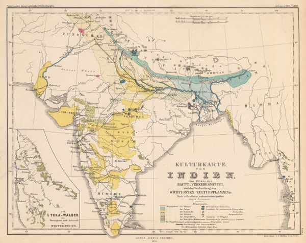
Justus Perthes, Commodity map of India, 1859£ 125.00
-
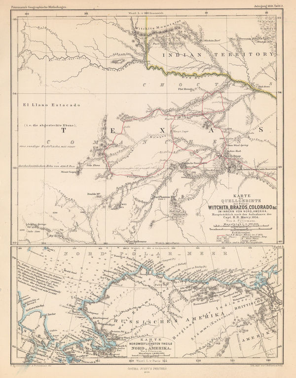
Justus Perthes, North Texas & Alaska, 1859£ 125.00
-
Justus Perthes, Colonial Possessions in the Pacific, 1859£ 125.00
-
Justus Perthes, Bajuda Desert, Sudan, 1859£ 125.00
-
Justus Perthes, Speke's journey to Lake Victoria, 1859£ 175.00
-
North Africa - Map Showing the Caravan routes between Tripoli and Ghadamis, 1859Royal Geographical Society (RGS)Series: LondonRoyal Geographical Society (RGS), North Africa - Map Showing the Caravan routes between Tripoli and Ghadamis, 1859£ 125.00
-
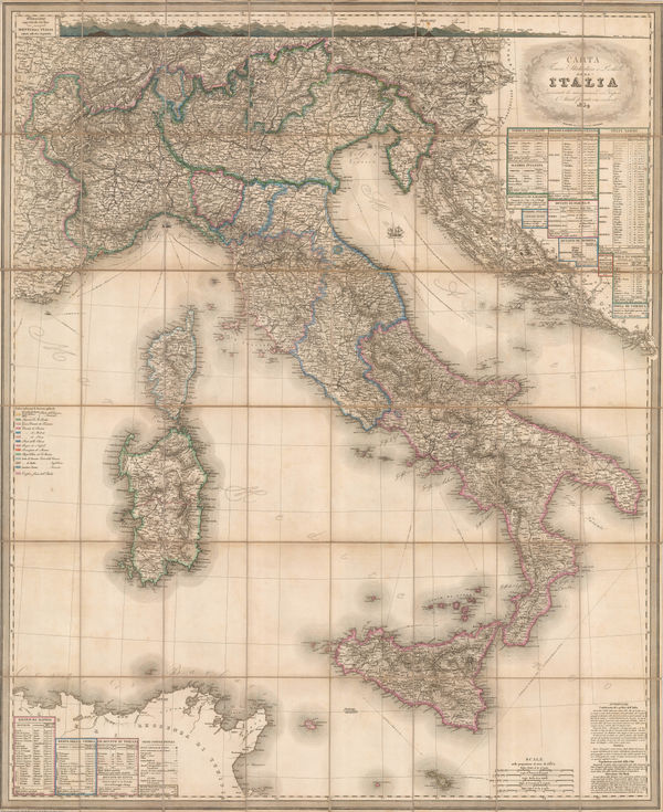
Stanislao Stucchi, Wall Map of Italy prior to Unification, 1859£ 1,350.00
-
Gall & Inglis, Map of Arabia, 1859 c£ 395.00
-
Henry Francis Walling, A New Map of the Vicinity of Boston, 1860£ 950.00
-
Archibald Fullarton, Aberdeen, 1860£ 54.00
-
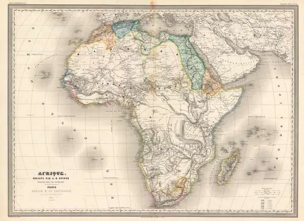
Auguste-Henri Dufour, French Atlas map of Africa, 1860£ 495.00
-
F.A. Garnier, Asia, 1860£ 245.00
-
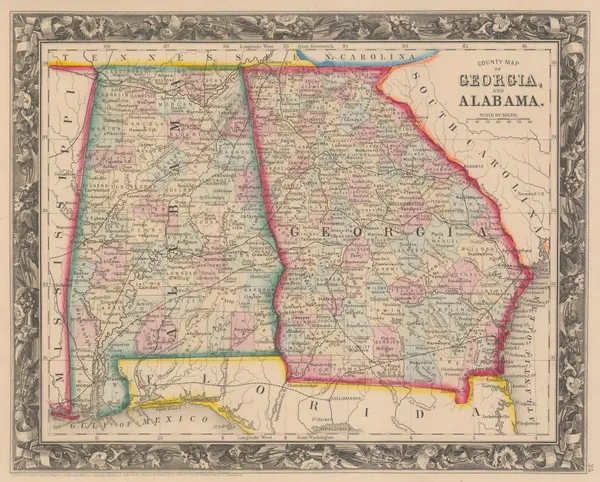
Samuel Augustus Mitchell, County Map of Georgia and Alabama, 1860£ 145.00
-
Samuel Augustus Mitchell, County Map of Kentucky and Tennessee, 1860£ 95.00
-
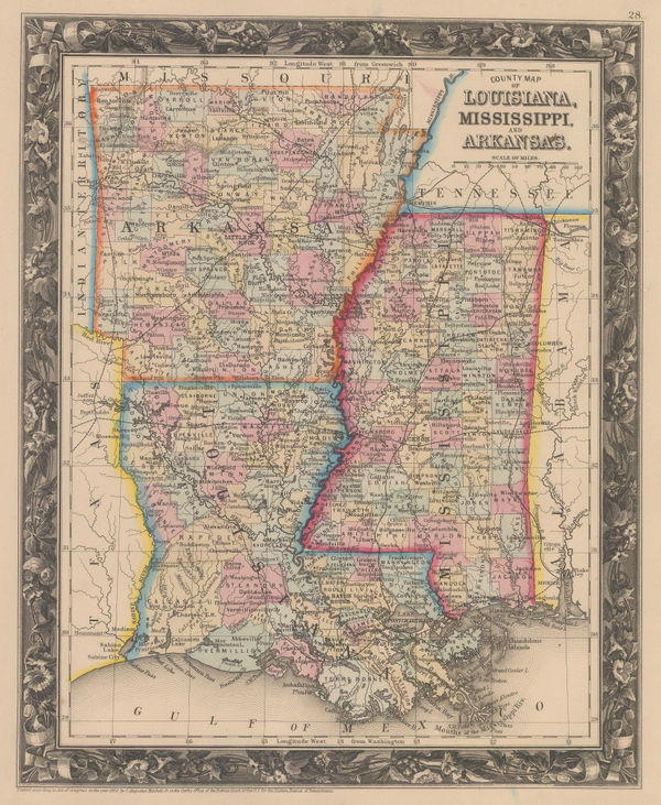
Samuel Augustus Mitchell, County Map of Louisiana, Mississippi and Arkansas, 1860£ 145.00
-
Samuel Augustus Mitchell, County Map of Ohio and Indiana, 1860£ 125.00
-
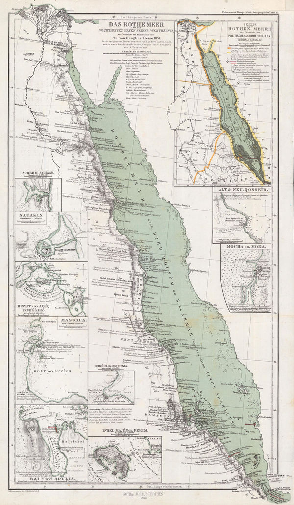
Justus Perthes, The Red Sea, 1860£ 78.00
-
Justus Perthes, Lakes Torrens and Gairdner, 1860£ 72.00
-
Auguste-Henri Dufour, Southeast Asia showing French and Portuguese Colonies, 1860£ 375.00
-
Auguste-Henri Dufour, Italy, Sicily, Sardinia and Corsica, 1860£ 345.00
-
Justus Perthes, Gulf of Aden, 1860£ 225.00
-
Justus Perthes, Lake Khövsgöl & Irkutsk, 1860£ 78.00
-
Samuel Augustus Mitchell, Asia with political divisions, 1860£ 68.00
-
Samuel Augustus Mitchell, Map of Mexico, Central America and the West Indies, 1860£ 275.00
-
-
W. & A.K. Johnston, Map of the Chinese Rebellion, 1860£ 1,200.00
-
Map Showing the Routes travelled by the Command of Maj. E. Steen U.S. Dragn., 1860Lt. Joseph DixonSeries: Washington, D.C.Lt. Joseph Dixon, Map Showing the Routes travelled by the Command of Maj. E. Steen U.S. Dragn., 1860£ 750.00
-
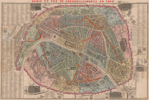
A. Bernard, Paris divided into 20 Arrondissements, 1860£ 950.00
-
Service Hydrographique de la Marine, Rare chart of Panarea, Aeolian Islands, 1860£ 350.00
-
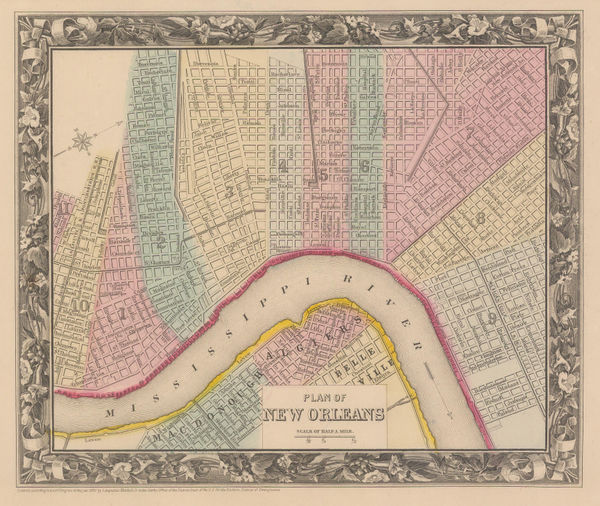
Samuel Augustus Mitchell, Plan of New Orleans, 1860£ 225.00
-
Samuel Augustus Mitchell, Plan of Philadelphia, 1860£ 225.00
-
Auguste-Henri Dufour, Turkey, Syria, Iraq, Cyprus, the Levant and the Black Sea, 1860£ 225.00
-
Justus Perthes, Environs of Beijing / Province of Pe-Tschili, 1860£ 82.00
-
Eugène Andriveau-Goujon, East & Southeast Asia, 1860£ 885.00
-
Samuel Augustus Mitchell, County Map of Texas, 1860£ 495.00
-
G. C. Castellini, Monaco, 1860£ 1,450.00
-
D.T. Valentine, Map of the City & County of New York, 1860£ 875.00
-
James Miller, New York City Map, 1860 (c.)£ 1,150.00
-
James Wyld, Allied Forces in Western China and Beijing, 1860 (c.)£ 2,950.00
-
Archibald Fullarton, Scilly Isles, 1860 (c.)£ 75.00
-
A. Fullarton & Co., Dorsetshire, 1860 c£ 68.00
-
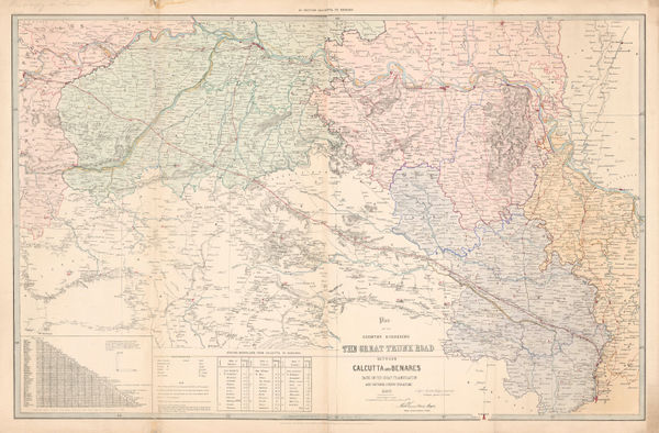
Survey of India, Grand Trunk Road of India between Calcutta and Benares, 1860 c£ 2,000.00
-
Survey of India, Great Trunk Road of India between Benares and Delhi, 1860 c£ 4,000.00
-
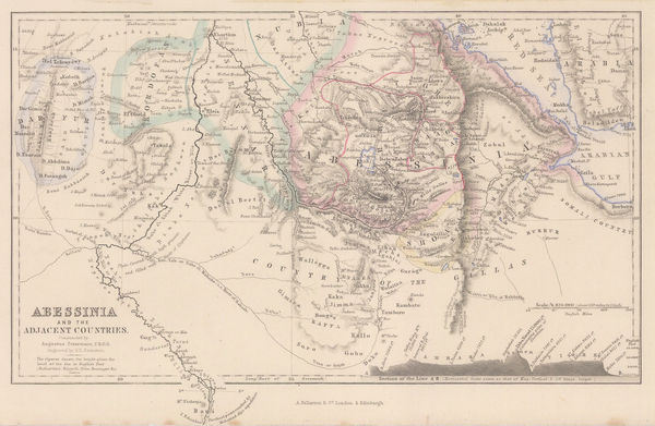
Archibald Fullarton, Abyssinia, 1860 c.£ 68.00
-
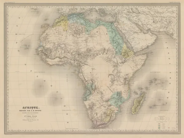
Archibald Fullarton, Africa, 1860 c.£ 325.00
-
Victor Levasseur, Africa, 1860 c.£ 395.00
-
Victor Levasseur, Algérie (Northern Algeria), 1860 c.£ 195.00
-
Daniel & William Lizars, America, 1860 c.£ 350.00
-
Auguste-Henri Dufour, North America, 1860 c.£ 325.00
-
John Dower, Asia, 1860 c.£ 125.00
-
Archibald Fullarton, Asia, 1860 c.£ 85.00
-
John Rapkin, Anatolia (Turkey) Cyprus and Rhodes, 1860 c.£ 82.00
-
Justus Perthes, Asia, 1860 c.£ 80.00
-
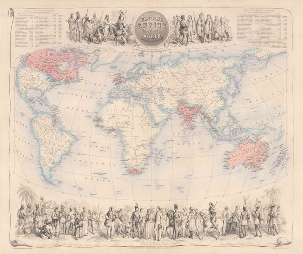
British Empire Throughout the World Exhibited in One View, 1860 c.Archibald FullartonSeries: Edinburgh, London & DublinArchibald Fullarton, British Empire Throughout the World Exhibited in One View, 1860 c.£ 2,250.00
-
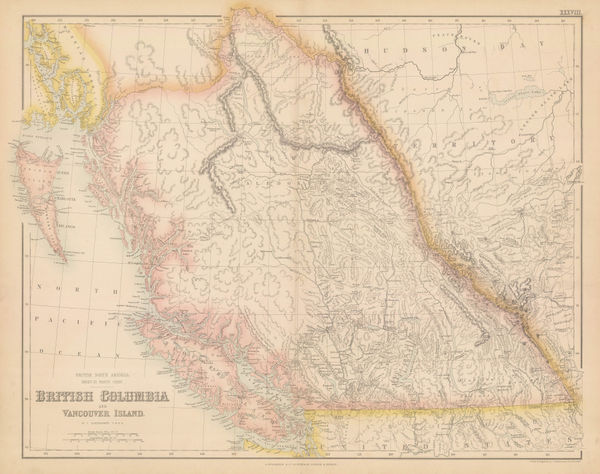
Archibald Fullarton, British Columbia & Vancouver Island, 1860 c.£ 545.00
-
Archibald Fullarton, Trinidad and Guyana, 1860 c.£ 295.00
-
Archibald Fullarton, Buteshire, 1860 c.£ 38.00
-
Archibald Fullarton, Caithness Shire, 1860 c.£ 48.00
-
Victor Levasseur, Carte Administrative et Physique de L'Angleterre, 1860 c.£ 175.00
-
John Dower, Northern Chile and Argentina, 1860 c.£ 75.00
-
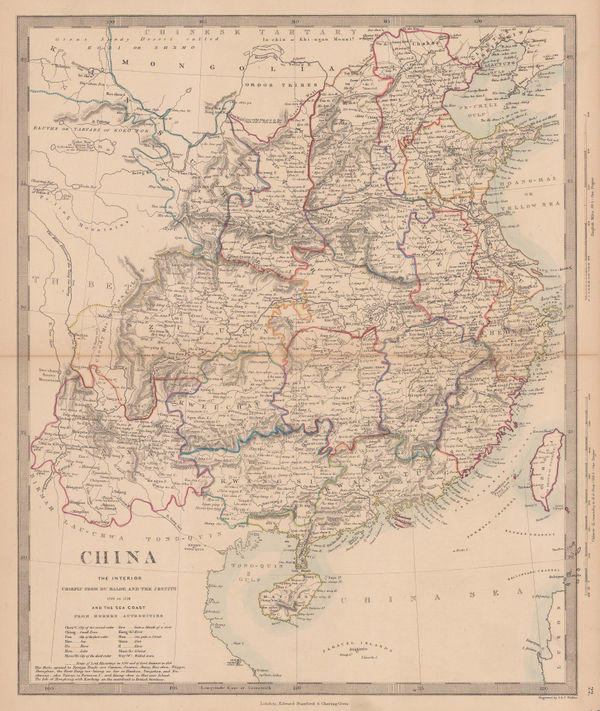
Society for Promoting Christian Knowledge (SPCK), China, 1860 c.£ 195.00
-
Archibald Fullarton, Ethiopia & Central Africa, 1860 c.£ 195.00
-
Archibald Fullarton, Crimea, 1860 c.£ 58.00
-
George Frederick Cruchley, Cruchley's Reduced Ordnance Map - Sheet 26, 1860 c.£ 295.00
-
Royal Geographical Society (RGS), Dr. Barth's Route from Tin-Tellust to Agadez, 1860 c.£ 185.00
-
Archibald Fullarton, Dumfries shire, 1860 c.£ 44.00
-
Suriname and the Dutch Caribbean islands, 1860 c.Archibald FullartonSeries: London, Edinburgh & DublinArchibald Fullarton, Suriname and the Dutch Caribbean islands, 1860 c.£ 325.00
-
East Canada and New Brunswick, 1860 c.Society for the Diffusion of Useful Knowledge (SDUK)Series: LondonSociety for the Diffusion of Useful Knowledge (SDUK), East Canada and New Brunswick, 1860 c.£ 95.00
-
Coast of Bahia and the Province of Rio de Janeiro, 1860 c.Archibald FullartonSeries: Edinburgh, London & DublinArchibald Fullarton, Coast of Bahia and the Province of Rio de Janeiro, 1860 c.£ 295.00
-
John Dower, East India Isles, 1860 c.£ 195.00
-
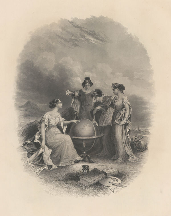
Frontispiece: Colton's General Atlas Of The World, Containing Two Hundred And Twelve Maps And Plans, 1860 c.George Woolworth ColtonSeries: PhiladelphiaGeorge Woolworth Colton, Frontispiece: Colton's General Atlas Of The World, Containing Two Hundred And Twelve Maps And Plans, 1860 c.£ 95.00
-
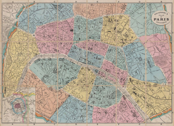
A. & W. Galignani & Co., Paris divided into Arrondissements, 1860 c.£ 345.00
-
Archibald Fullarton, General Map of Channel Islands, 1860 c.£ 86.00


Page
79
of 131