-
 J. Domingo Sulsona, Puerto Rico, 1899£ 985.00
 -
One-Inch OS Map of Stratford-upon-Avon, Leamington Spa & Banbury, 1899Ordnance SurveySeries: SouthamptonOrdnance Survey, One-Inch OS Map of Stratford-upon-Avon, Leamington Spa & Banbury, 1899£ 295.00
-
Edward Stanford, Africa, 1899 c.£ 685.00
-
Charles Booth, Battersea & Clapham Poverty Map, 1900£ 1,650.00
-
Charles Edward Goad, Cambridge, 1900£ 325.00
-
Scottish Geographical Society (SGS), Chart of the South Polar Regions, 1900£ 725.00
-
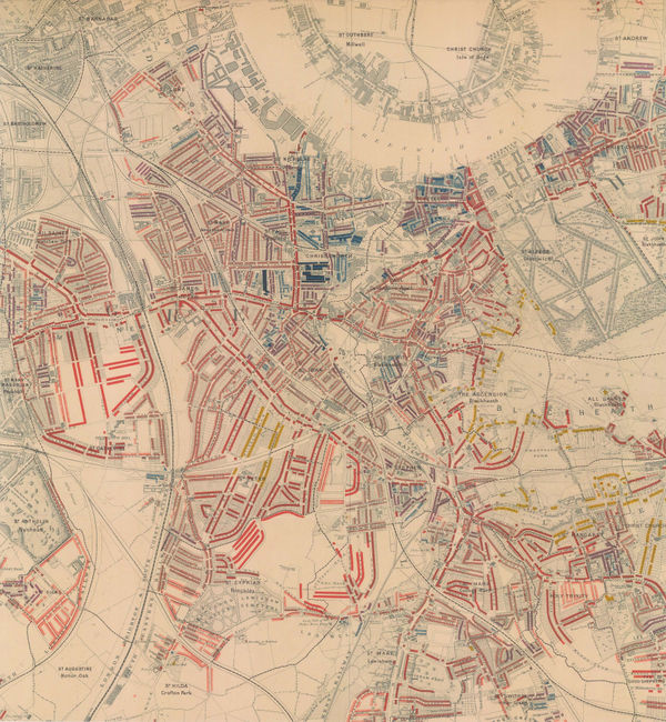
Charles Booth, Poverty Map of Greenwich, Deptford & Lewisham, 1900£ 1,275.00
-
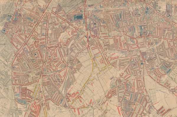
Charles Booth, Poverty Map of Stoke Newington, Dalston, Haggerston & Hackney, 1900£ 795.00
-
Arthur Cotton, Irrigation and Navigation Map of India, 1900£ 695.00
-
Anonymous, Japanese Binoculars, 1900£ 4,500.00
-
James Gall, Map 12. Taurus, 1900£ 45.00
-
James Gall, Map 16. Leo, 1900£ 45.00
-
James Gall, Map 2. Cassiopeia & Cepheus, 1900£ 45.00
-
James Gall, Map 20. Serpens & Ophiuchus, 1900£ 45.00
-
James Gall, Map 21. Hercules, the Crown, and Ophiuchus, 1900£ 45.00
-
James Gall, Map 24. Aquarius, Capricorn & Piscis Australis, 1900£ 55.00
-
James Gall, Map 5. Draco, 1900£ 45.00
-
James Gall, Map 7. Cygnus, 1900£ 45.00
-
James Gall, Map 8. Aquila & Delphinus, 1900£ 45.00
-
James Gall, Map 9. Pegasus, 1900£ 45.00
-
Map of Part of the Coastline of South Victoria Land, 1900Royal Geographical Society (RGS)Series: LondonRoyal Geographical Society (RGS), Map of Part of the Coastline of South Victoria Land, 1900£ 2,650.00
-
Map of the Baram District, Sarawak, Northern Borneo, 1900Royal Geographical Society (RGS)Series: LondonRoyal Geographical Society (RGS), Map of the Baram District, Sarawak, Northern Borneo, 1900£ 1,150.00
-
Map Shewing The Gold Districts of Mashonaland & Matabeleland, 1900Scottish Geographical Society (SGS)Series: EdinburghScottish Geographical Society (SGS), Map Shewing The Gold Districts of Mashonaland & Matabeleland, 1900£ 395.00
-
Map Showing Places of Religious Worship, Public Elementary Schools, and Houses Licensed for the Sale of Intoxicating Drinks, 1900Charles BoothSeries: LondonCharles Booth, Map Showing Places of Religious Worship, Public Elementary Schools, and Houses Licensed for the Sale of Intoxicating Drinks, 1900£ 2,950.00
-
Map to Illustrate Explorations in North East Africa, 1900Royal Geographical Society (RGS)Series: LondonRoyal Geographical Society (RGS), Map to Illustrate Explorations in North East Africa, 1900£ 325.00
-
F Bianconi, Southern Africa during the Boer War, 1900£ 495.00
-
Charles Booth, Poverty Map of Bow, Poplar, Stepney & Limehouse, 1900£ 745.00
-
Charles Booth, Poverty Map of Peckham, Brixton & Camberwell, 1900£ 1,250.00
-
Royal Geographical Society (RGS), Part of Tibet and Sin-Chiang, 1900£ 545.00
-
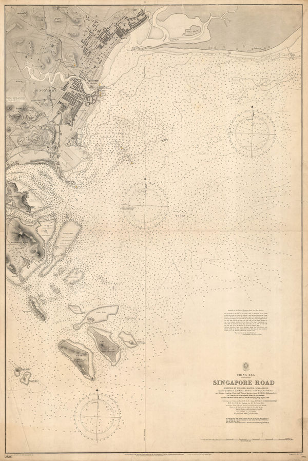
British Admiralty, Singapore Sea Chart, 1900£ 3,750.00
-
Royal Geographical Society (RGS), La Paz and environs, 1900£ 225.00
-
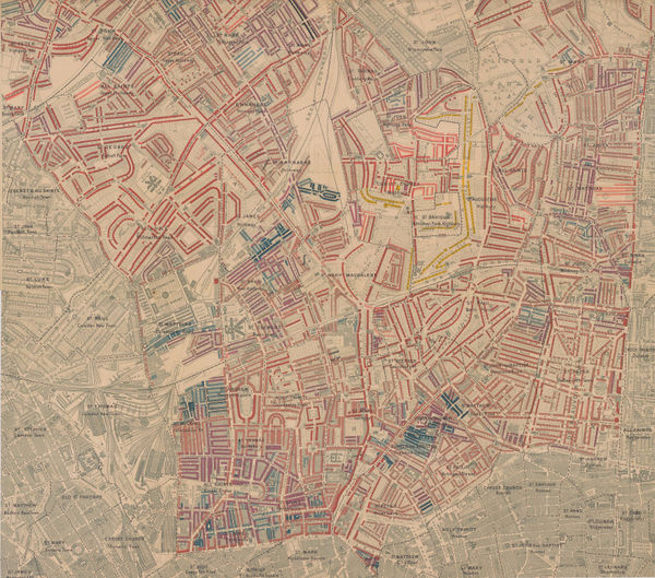
Charles Booth, Poverty Map of Notting Hill, Hammersmith & West Kensington, 1900£ 1,650.00
-
Rand, McNally & Co., Washington, 1900£ 400.00
-
Thomas Ferguson, Waterways near Shanghai, 1900£ 4,500.00
-
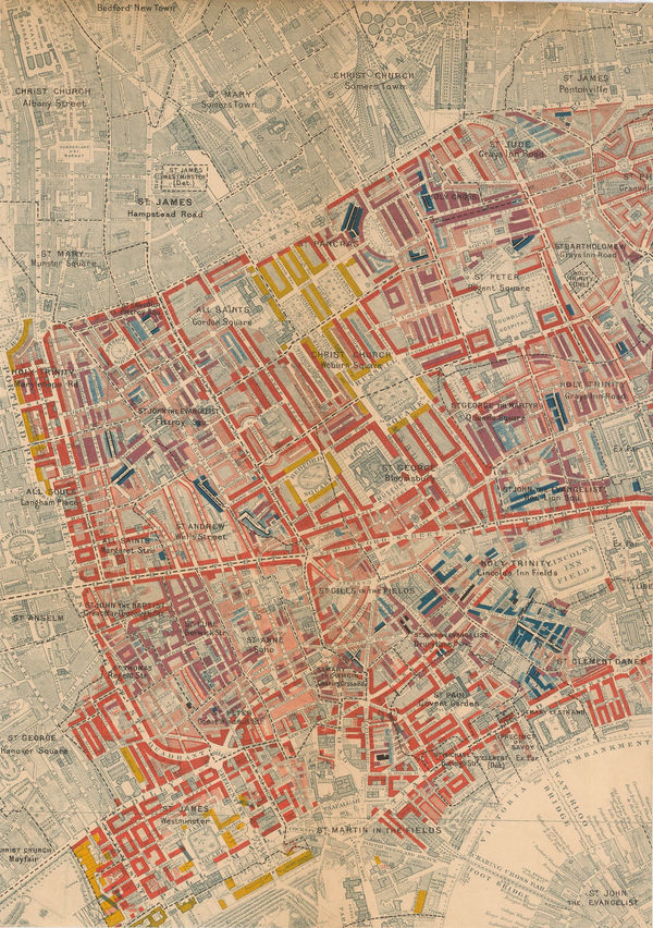
Charles Booth, West Central London, 1900£ 925.00
-
Ordnance Survey, Windsor and Ascot, 1900£ 1,200.00
-
Charles Booth, Poverty Map of Islington, Highbury, & Stoke Newington, 1900£ 1,550.00
-
Charles Booth, Poverty Map of Camden, King's Cross & Kentish Town, 1900£ 985.00
-
George W. Bacon, Tottenham, Walthamstow, Edmonton & Epping Forest, 1900£ 195.00
-
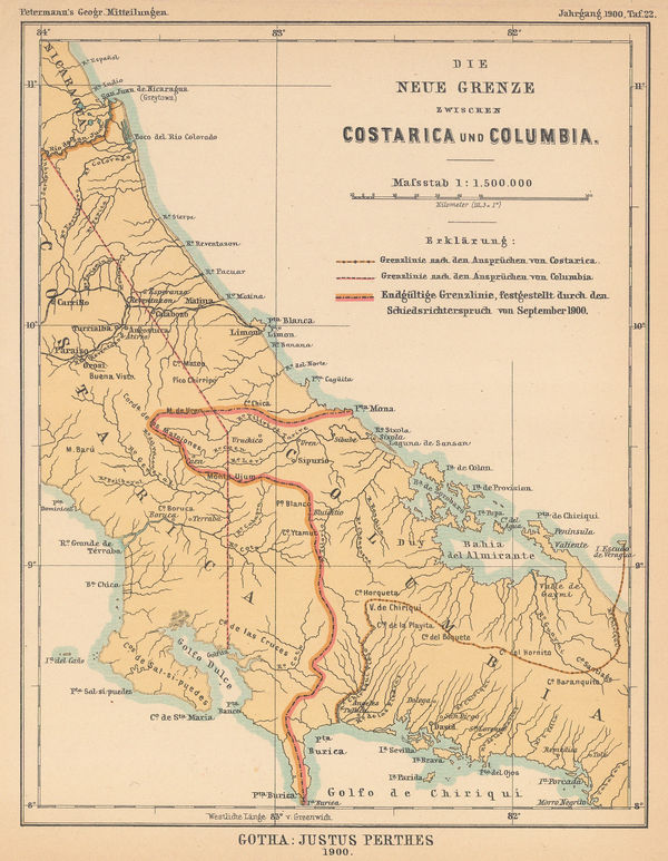
Justus Perthes, Settling the Costa Rica-Colombia Border Dispute, 1900£ 145.00
-
Scottish Geographical Society (SGS), A Map of Rhodesia, 1900£ 375.00
-
Wood & Ortlepp, "Briton or Boer" Special Map of the Boer Republics, 1900£ 850.00
-
Royal Geographical Society (RGS), The First European Ascent of Mount Kenya, 1900£ 375.00
-
George W. Bacon, South & Southwest London, 1900£ 395.00
-
Charles Booth, East Central London, 1900£ 775.00
-
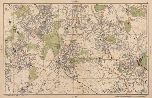
George W. Bacon, Tooting, Dulwich & Streatham, 1900£ 245.00
-
George W. Bacon, Twickenham, Teddington & Richmond Park, 1900£ 295.00
-
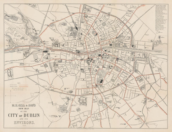
M. H. Gill, New Map of the City of Dublin, 1900£ 495.00
-
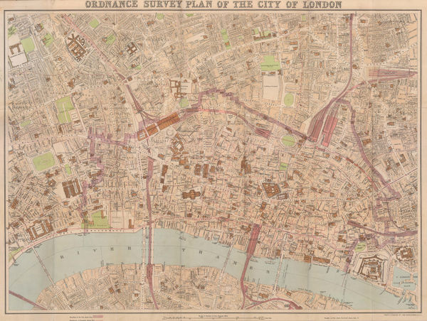
John Bartholomew, Ordnance Survey Plan of the City of London, 1900 (c.)£ 745.00
-
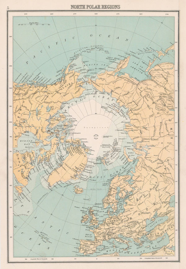
John Bartholomew & Co., North Polar Regions, 1900 (c.)£ 95.00
-
George Philip & Son Ltd., New Zealand, 1900 (c.)£ 450.00
-
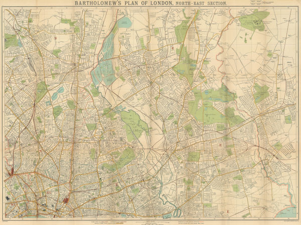
J.G. Bartholomew, North & East London, 1900 (c.)£ 375.00
-
John Bartholomew & Co., Geological Map of Scotland, 1900 (c.)£ 550.00
-
Rand McNally, New Map of New York City, 1900 (c.)£ 375.00
-
Star Map of the Northern & Southern Hemispheres, 1900 (c.)William ChambersSeries: London, Edinburgh & New YorkWilliam Chambers, Star Map of the Northern & Southern Hemispheres, 1900 (c.)£ 345.00
-
Larousse, Paris , 1900 c£ 125.00
-
J.G. Bartholomew, Cambridge, 1900 c£ 145.00
-
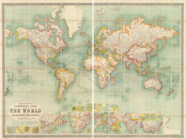
Commercial Chart of the World on Mercator's Projection., 1900 cGeorge Philip & Son Ltd.Series: LondonGeorge Philip & Son Ltd., Commercial Chart of the World on Mercator's Projection., 1900 c£ 4,500.00
-
F.A. Brockhaus, Papua New Guinea and the Solomon Islands, 1900 c£ 195.00
-
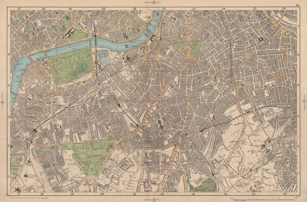
George Philip & Son Ltd., New Plan of London, 1900 c£ 950.00
-
George Philip & Son Ltd., Willesden, Cricklewood & Dollis Green, 1900 c.£ 36.00
-
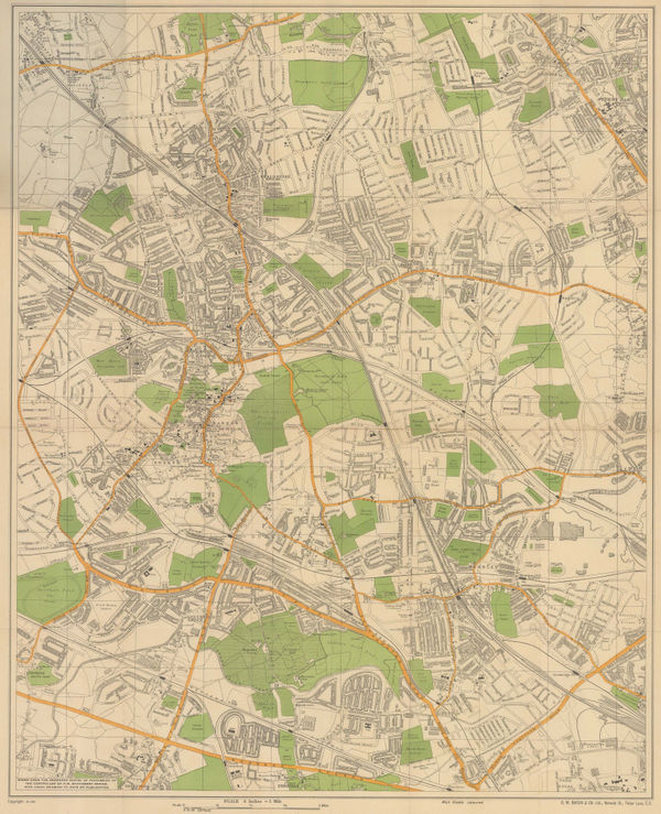
George Philip & Son Ltd., Golders Green, Brent Cross & Hendon, 1900 c.£ 44.00
-
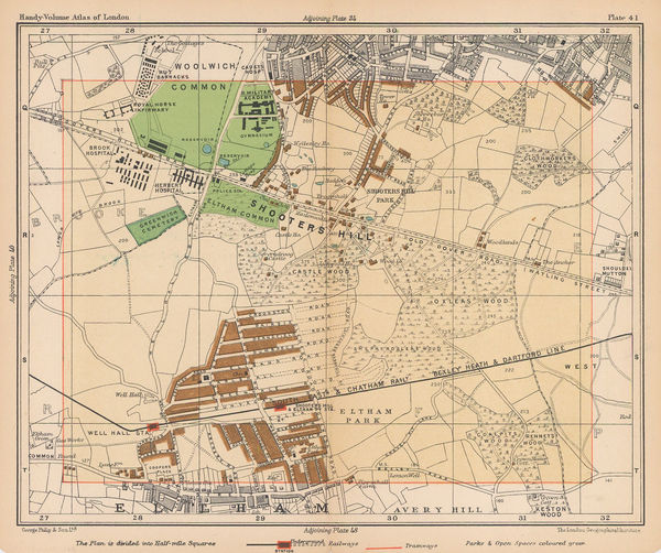
George Philip & Son Ltd., Shooters Hill & Eltham Park, 1900 c.£ 38.00
-
George W. Bacon, Bolton, 1900 c.£ 175.00
-
Anonymous, Belgium and Netherlands, 1900 c.£ 38.00
-
Karl Baedeker, Geneva, 1900 c.£ 58.00
-
George W. Bacon, Large Scale Plan of Harrow, 1900 c.£ 115.00
-
Wagner & Debes, Lausanne, 1900 c.£ 32.00
-
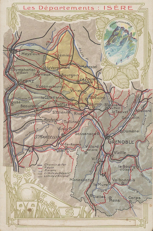
Chocolat d'Aiguebelle, Isère, 1900 c.£ 48.00
-
Karl Baedeker, Central and southern Mexico, 1900 c.£ 38.00
-
George Philip, Map of the Eastern Indian Railway, 1900 c.£ 385.00
-
New Map, with compliments of the Broadway Central Hotel, 1900 c.Tilly HaynesSeries: Springfield, Mass.Tilly Haynes, New Map, with compliments of the Broadway Central Hotel, 1900 c.£ 175.00
-
J.G. Bartholomew, Plan of Aberdeen, 1900 c.£ 125.00
-
George W. Bacon, Bradford, 1900 c.£ 95.00
-
George W. Bacon, Brighton & Hove, 1900 c.£ 395.00
-
The Times Map of British South Africa, the Transvaal and Orange Free State, 1900 c.The TimesSeries: LondonThe Times, The Times Map of British South Africa, the Transvaal and Orange Free State, 1900 c.£ 695.00
-
Andrew Iredale, Torquay, 1900 c.£ 450.00
-
Karl Baedeker, Canada, 1900 c.£ 58.00
-
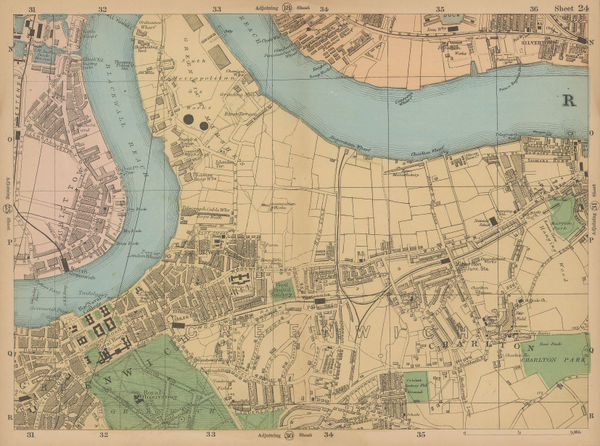
George W. Bacon, Greenwich & Charlton, 1900 c.£ 62.00
-
Karl Baedeker, Lake Lugano, 1900 c.£ 38.00


Page
103
of 130