-
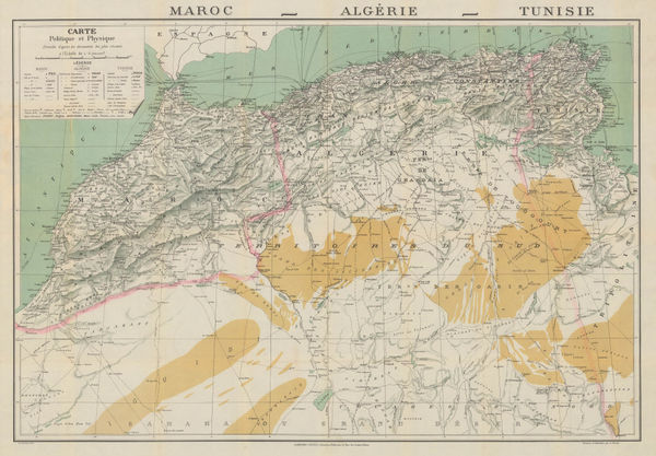
 Garnier Frères, Morocco, Algeria & Tunisia, 1900 c.£ 195.00
 -
Troughton & Simms, Surveyor's Theodolite, 1900 c.£ 4,000.00
-
W. & A.K. Johnston, Japan, Korea & Taiwan, 1900 c.£ 88.00
-
W. & A.K. Johnston, Thailand, Cambodia, Laos & Vietnam, 1900 c.£ 95.00
-
George W. Bacon, Plan of Cheltenham, 1900 c.£ 225.00
-
W. & A.K. Johnston, Bombay Island & Town, 1900 c.£ 115.00
-
Antonio Vallardi, Aeolian Islands, 1900 c.£ 55.00
-
Charles Booth, Poverty Map of Hampstead and St. John's Wood, 1900 c.£ 1,350.00
-
John Bartholomew & Co., Brighton, 1900 c.£ 195.00
-
George W. Bacon, Large Scale Plan of Newcastle, 1900 c.£ 395.00
-
John Bartholomew, Manchester and Salford, 1900 c.£ 375.00
-
War Office, Early 20th century plan of Beijing (Peking), 1900 c.£ 4,500.00
-
Cassell & Company, London and Environs, 1900 c.£ 125.00
-
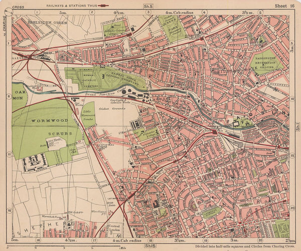
George W. Bacon, North Kensington, Kensal Green, Queens Park & Wormwood Scrubs, 1900 c.£ 165.00
-
George Cram, Idaho, 1900 c.£ 185.00
-
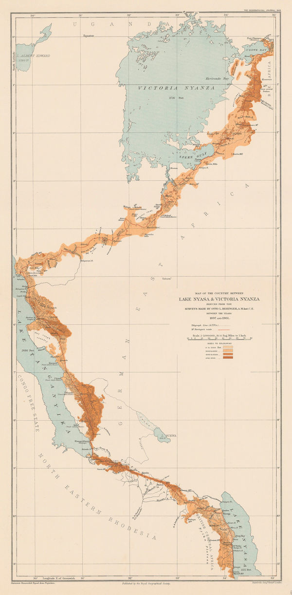
Royal Geographical Society (RGS), A Map of Marotseland, 1901£ 425.00
-
Karl Baedeker, Alicante, 1901£ 42.00
-
Rand, McNally & Co., City of Havana, 1901£ 395.00
-
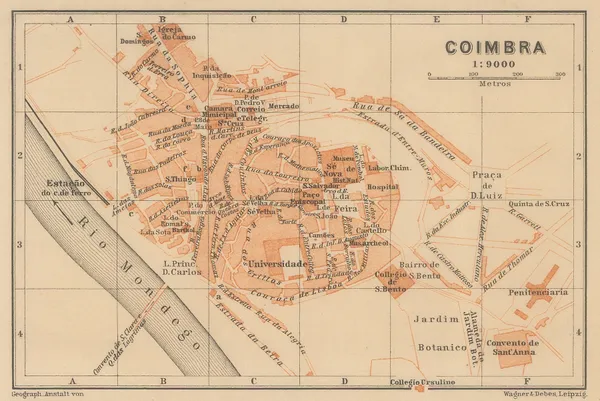
Karl Baedeker, Coimbra, 1901£ 38.00
-
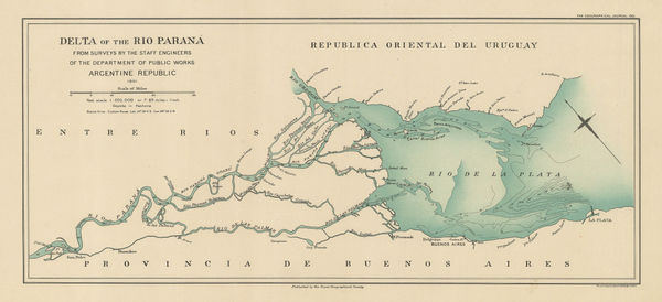
Royal Geographical Society (RGS), Delta of the Rio Parana, 1901£ 225.00
-
-
Karl Baedeker, Malaga, 1901£ 58.00
-
Royal Geographical Society (RGS), Great Bear Lake and environs, 1901£ 95.00
-
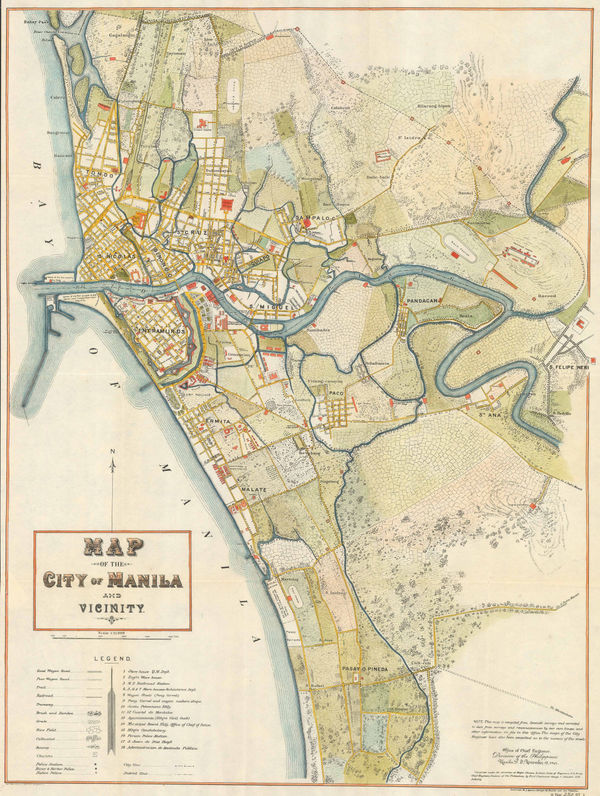
George F. Stewart, Map of the City of Manila and Vicinity, 1901£ 2,450.00
-
Rand, McNally & Co., Rand McNally & Co's Map of the World, 1901£ 985.00
-
Sketch of Danco Land the Belgica Strait and Palmer Archipelago, 1901Royal Geographical Society (RGS)Series: LondonRoyal Geographical Society (RGS), Sketch of Danco Land the Belgica Strait and Palmer Archipelago, 1901£ 850.00
-
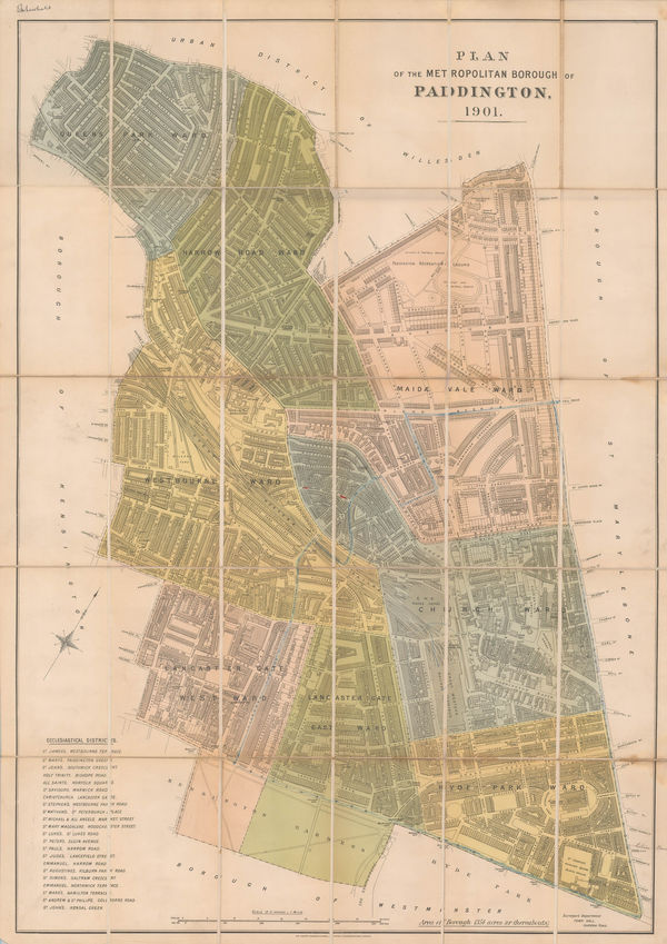
Sir Joseph Causton & Sons, The Metropolitan Borough of Paddington, 1901£ 950.00
-
Where to Go and How to Get There Map of Colororado Springs and Colorado City, 1901Gilbert McClurgSeries: Colorado SpringsGilbert McClurg, Where to Go and How to Get There Map of Colororado Springs and Colorado City, 1901£ 445.00
-
Richard Anthony Proctor, Stars for July & August, 1901£ 95.00
-
Richard Anthony Proctor, Stars for August & September, 1901£ 95.00
-
Karl Baedeker, Granada, 1901£ 85.00
-
Edward Stanford, Alexandria, 1901£ 62.00
-
Edward Stanford, The Country Around Jerusalem, 1901£ 65.00
-
Edward Stanford, Naples, 1901£ 72.00
-
Edward Stanford, Naples & the Amalfi Coast, 1901£ 64.00
-
Edward Stanford, Cairo, 1901£ 78.00
-
Edward Stanford, Malta & Gozo, 1901£ 115.00
-
Ethelbert William Bullinger, V. Libra (The Scales), 1901£ 75.00
-
Edward Stanford, Damascus, 1901£ 55.00
-
Royal Geographical Society (RGS), Map of Central Kurdistan by Major F.R. Maunsell, 1901£ 155.00
-
Edward Stanford, Jerusalem, 1901£ 145.00
-
Richard Anthony Proctor, Stars for September & October, 1901£ 95.00
-
Royal Geographical Society (RGS), Delta of the Amazon, 1901£ 195.00
-
Richard Anthony Proctor, Stars for October & November, 1901£ 85.00
-
Bacon's County Map and Guide, Gloucester with parts of Adjoining Counties, 1901 c.George W. BaconSeries: LondonGeorge W. Bacon, Bacon's County Map and Guide, Gloucester with parts of Adjoining Counties, 1901 c.£ 75.00
-
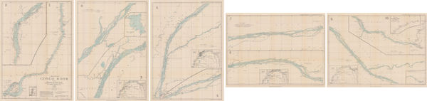
Royal Geographical Society (RGS), The Congo River, 1902£ 445.00
-
Dr. G.A.F Molengraff, Geological Sketchmap of the Transvaal, 1902£ 825.00
-
British Admiralty, Sea Chart of Seattle & Tacoma, 1902£ 1,950.00
-
Land Journey from Nasser to the Uganda Railway at Lake Nakuro, 1902Royal Geographical Society (RGS)Series: LondonRoyal Geographical Society (RGS), Land Journey from Nasser to the Uganda Railway at Lake Nakuro, 1902£ 185.00
-
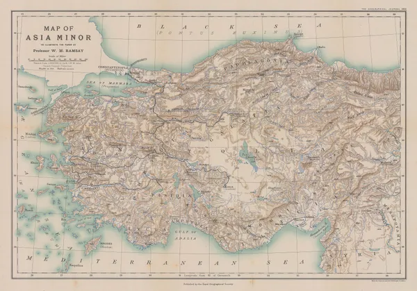
Royal Geographical Society (RGS), Map of Asia Minor, 1902£ 225.00
-
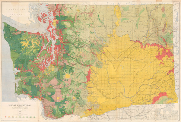
George Howard Plummer, Timber Map of Washington State, 1902£ 2,750.00
-
Royal Geographical Society (RGS), Xinjiang province, western China, 1902£ 445.00
-
Royal Geographical Society (RGS), Iran, Arghanistan and Pakistan, 1902£ 325.00
-
Survey of India, Railway System of India, 1902£ 585.00
-
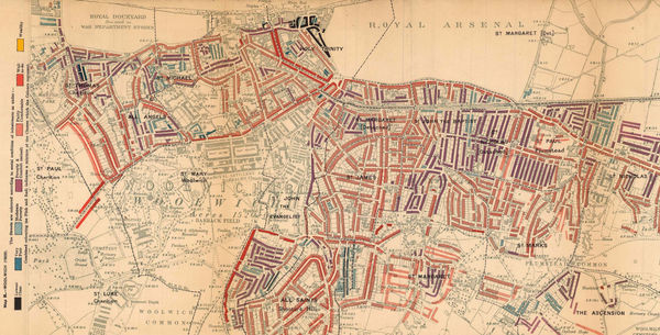
Charles Booth, Poverty Map of Woolwich & Plumstead, 1902£ 325.00
-
George Philip & Son Ltd., Ipswich and Environs, 1902£ 275.00
-
George W. Bacon, Bayswater, Kensington, Paddington, Kilburn & Queens Park, 1902£ 68.00
-
-
Charles Booth, Isle of Dogs, 1902£ 395.00
-
The "District Map" of Greater London and Environs - 1st Edition, 1902Sampson Low, Marston & CompanySeries: LondonSampson Low, Marston & Company, The "District Map" of Greater London and Environs - 1st Edition, 1902£ 400.00
-
C. Legresle, La Cote d'Azur, 1902£ 895.00
-
Royal Geographical Society (RGS), Rwanda, Burundi, Tanzania and Uganda, 1902£ 195.00
-
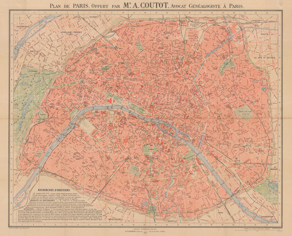
A. Simon, Plan of Paris, 1902£ 325.00
-
Kenyon Printing & Mfg. Co., Map of Colorado, 1902£ 275.00
-
John Bartholomew, Belfast, 1902£ 65.00
-
Weyss, Map of the United States and Texas Boundary and adjacent Territory, 1902£ 775.00
-
Century Company, California Northern Part, 1902£ 75.00
-
Royal Geographical Society (RGS), Uganda, 1902£ 525.00
-
Waterlow & Sons, The Isle of Wight, 1902£ 150.00
-
George Philip & Son Ltd., The Daily Mail Map of the Boer Republics, 1902 c.£ 445.00
-
W. & A.K. Johnston, 6-Inch W. & A.K. Johnston's Globe, 1902 c.£ 500.00
-
Edward Stanford, A Chart of the World on Mercator's Projection, 1903£ 1,450.00
-
Edward Stanford, Map of China prepared for The China Inland Mission, 1903£ 3,500.00
-
Royal Geographical Society (RGS), Earthquake Districts of the World, 1903£ 165.00
-
Map Showing Discoveries of Commander Peary's Expedition, 1900-2, 1903Scottish Geographical Society (SGS)Series: EdinburghScottish Geographical Society (SGS), Map Showing Discoveries of Commander Peary's Expedition, 1900-2, 1903£ 285.00
-
Hawaiian Government Survey, Maui - Hawaiian Islands, 1903£ 3,450.00
-
Royal Geographical Society (RGS), Mexico, 1903£ 110.00
-
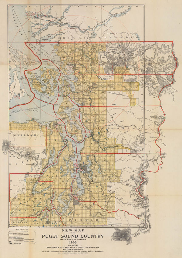
New Map of the Puget Sound Country - Seattle, 1903Bellingham Bay Abstract & Title Insurance Co.Series: WashingtonBellingham Bay Abstract & Title Insurance Co., New Map of the Puget Sound Country - Seattle, 1903£ 1,950.00
-
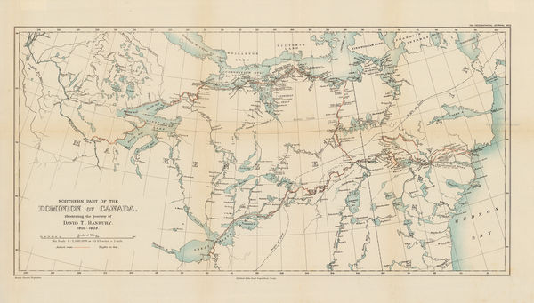
Royal Geographical Society (RGS), Northeastern Canada, 1903£ 295.00
-
Rand, McNally & Co., Oregon, 1903£ 395.00


Page
104
of 131