-
 Baddeley and Ward, Penzance, 1903£ 45.00
 -
Royal Geographical Society (RGS), Capri & Pozzuoli, 1903£ 115.00
-
Part of the Canadian Rocky Mountains, British Columbia, 1903Royal Geographical Society (RGS)Series: LondonRoyal Geographical Society (RGS), Part of the Canadian Rocky Mountains, British Columbia, 1903£ 275.00
-
Sketch Map to Illustrate the North Polar Explorations, 1903Royal Geographical Society (RGS)Series: LondonRoyal Geographical Society (RGS), Sketch Map to Illustrate the North Polar Explorations, 1903£ 225.00
-
Royal Geographical Society (RGS), South Western China, 1903£ 195.00
-
Royal Geographical Society (RGS), Uganda and Kenya, 1903£ 425.00
-
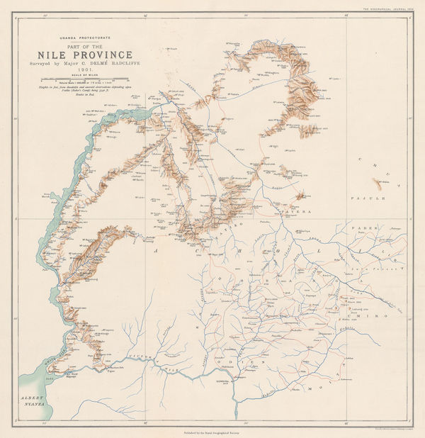
Royal Geographical Society (RGS), Northwest Uganda & the White Nile, 1903£ 225.00
-
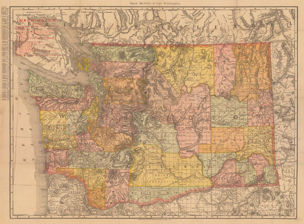
Rand, McNally & Co., Washington, 1903£ 445.00
-
Charles Edward Goad, Battersea Square, 1903£ 250.00
-
Charles Edward Goad, Battersea - Church Rd & Bolingbroke Walk, 1903£ 250.00
-
Emil Reich, Campaigns in India, 1903£ 55.00
-
Emil Reich, India in 1804, 1903£ 65.00
-
Emil Reich, Anglo-Mysore Wars, 1903£ 58.00
-
Emil Reich, Campaigns in India 1802-1852, 1903£ 62.00
-
Emil Reich, Battle of Marston Moor and Battle of Naseby, 1903£ 55.00
-
Emil Reich, Spanish Peninsular War, 1903£ 60.00
-
Emil Reich, The British Empire about 1800, 1903£ 70.00
-
Emil Reich, English Voyages of Discovery during the Tudor Period, 1903£ 68.00
-
Emil Reich, Roman Britain, 1903£ 58.00
-
Captain Sverdrup's Arctic Expedition in the 'Fram.' 1899-1902, 1903Scottish Geographical Society (SGS)Series: EdinburghScottish Geographical Society (SGS), Captain Sverdrup's Arctic Expedition in the 'Fram.' 1899-1902, 1903£ 325.00
-
Emil Reich, Wars of the Roses, 1903£ 55.00
-
Emil Reich, The Hundred Years' War I (1338-1396), 1903£ 60.00
-
Emil Reich, The Hundred Years' War II (1396-1453), 1903£ 60.00
-
Emil Reich, The Seven Years' War in Europe and America, 1903£ 65.00
-
C. J. Pilkey, Plan of the City of Toronto, 1903£ 625.00
-
H. T. Wade, Shanghai, Wuhu and Ningpo, 1903£ 4,500.00
-
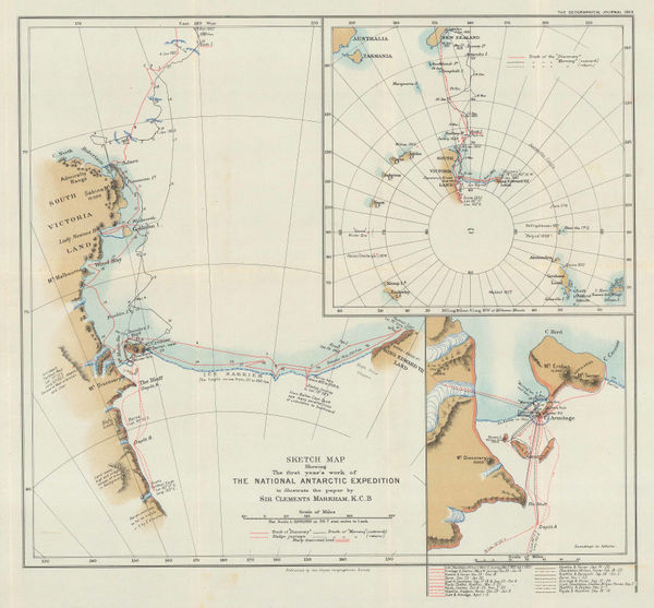
Sketch Map Showing the First Year's Work of The National Antarctic Exhibition, 1903Royal Geographical Society (RGS)Series: LondonRoyal Geographical Society (RGS), Sketch Map Showing the First Year's Work of The National Antarctic Exhibition, 1903£ 1,650.00
-
Homolka József, Budapest, 1903£ 2,450.00
-
British Admiralty, Wilkes Land, Adelie Land & George V Land, 1904£ 2,500.00
-
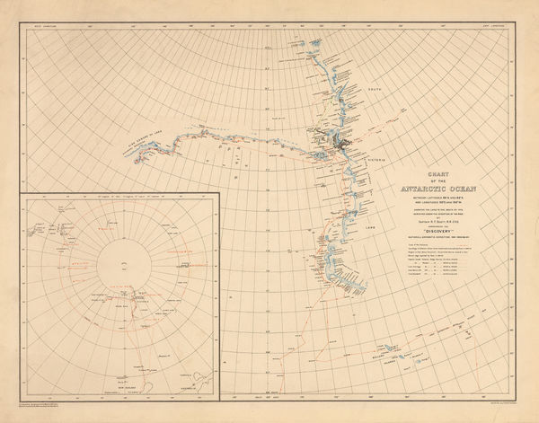
George F. A. Mulock, Chart of the Antarctic Ocean, 1904£ 1,750.00
-
Dawes Commission, Creek & Seminole Nations, Indian Territory, 1904£ 375.00
-
Geological Survey, Geological Map of London, 1904£ 725.00
-
Ordnance Survey, Geological Survey of England and Wales, 1904£ 150.00
-
British Admiralty, Hong Kong to Gulf of Liau-Tung, 1904£ 595.00
-
Dawes Commission, Indian Territory Showing Railroad Systems, 1904£ 225.00
-
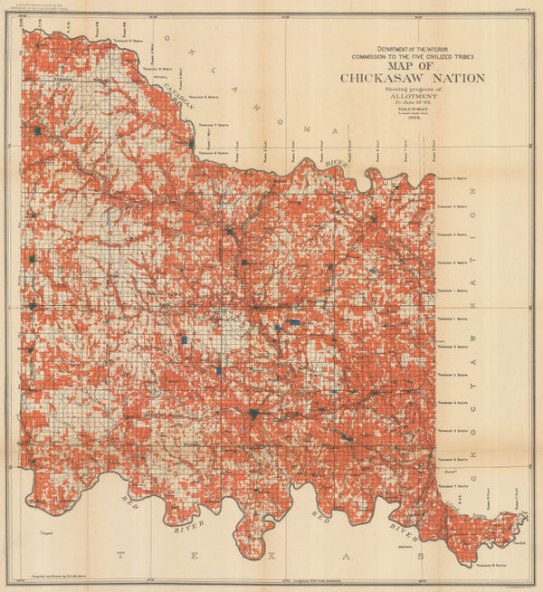
Dawes Commission, Map of Chickasaw Nation Showing progress of Allotment, 1904£ 450.00
-
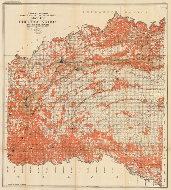
Dawes Commission, Map of Choctaw Nation, Indian Territory, 1904£ 450.00
-
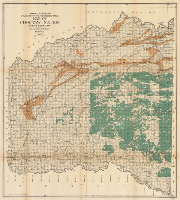
Map of Choctaw Nation. Indian Territory, Coal and Asphalt Segregation, 1904Dawes CommissionSeries: Washington, D.C.Dawes Commission, Map of Choctaw Nation. Indian Territory, Coal and Asphalt Segregation, 1904£ 450.00
-
Edward Weller, Map of the Orange River Colony, 1904£ 195.00
-
Edward Stanford, The Russo-Japanese War, 1904£ 1,450.00
-
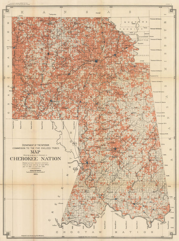
Dawes Commission, Map Showing Progress of Allotment in Cherokee Nation, 1904£ 375.00
-
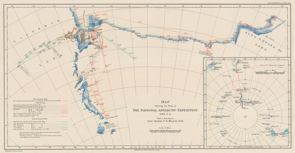
Map Showing the Work of The National Antarctic Expedition 1902-03-04, 1904Royal Geographical Society (RGS)Series: LondonRoyal Geographical Society (RGS), Map Showing the Work of The National Antarctic Expedition 1902-03-04, 1904£ 2,950.00
-
Royal Geographical Society (RGS), Map Showing Track of the S.Y. 'Morning', 1904£ 600.00
-
US Navy, Nassau Harbour, 1904£ 2,750.00
-
Columbus Lithograph, Railroad Map of Ohio, 1904£ 295.00
-
Scottish Geographical Society (SGS), Scottish National Antarctic Expedition, 1904£ 1,800.00
-
Royal Geographical Society (RGS), Sketch Map of Western Uganda, 1904£ 145.00
-
Royal Geographical Society (RGS), Journeys in Angola, 1904£ 115.00
-
Sketch Maps Showing the Track & Expeditions of the German South Polar Expedition 1902-3, 1904Royal Geographical Society (RGS)Series: LondonRoyal Geographical Society (RGS), Sketch Maps Showing the Track & Expeditions of the German South Polar Expedition 1902-3, 1904£ 750.00
-
Edward Stanford, The Canary Islands, 1904£ 175.00
-
The Position of the Main Ground-Water Table on Long Island, New York, 1904United States Geological Survey (USGS)Series: Washington, D.C.United States Geological Survey (USGS), The Position of the Main Ground-Water Table on Long Island, New York, 1904£ 495.00
-
The Seat of War: Bird's-Eye View of the Theatre of Operations, 1904The Graphic MagazineSeries: LondonThe Graphic Magazine, The Seat of War: Bird's-Eye View of the Theatre of Operations, 1904£ 325.00
-
George Bradshaw, Amsterdam, 1904£ 445.00
-
The Underground Electric Railways of London, 1904Underground Electric Railways Company of London (UERL)Series: LondonUnderground Electric Railways Company of London (UERL), The Underground Electric Railways of London, 1904£ 2,800 (framed)
-
George Bradshaw, Budapest, 1904£ 325.00
-
George Philip & Son Ltd., Hackney, Clapton, Leyton & Homerton, 1904£ 68.00
-
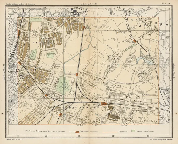
George Philip & Son Ltd., Lower Sydenham, Beckenham & Penge, 1904£ 58.00
-
Edward Stanford, South London, 1904£ 445.00
-
George Philip & Son Ltd., Wimbledon, Roehampton & Putney Heath, 1904£ 85.00
-
Edward Stanford, Palestine, 1904£ 200.00
-
Edward Stanford, Newfoundland, 1904£ 295.00
-
Sketch Map Showing the Track of the Swedish Antarctic Expedition, 1904Royal Geographical Society (RGS)Series: LondonRoyal Geographical Society (RGS), Sketch Map Showing the Track of the Swedish Antarctic Expedition, 1904£ 550.00
-
Edward Stanford, Athens, 1904£ 65.00
-
Edward Stanford, West Africa showing the British Possessions, 1904£ 275.00
-
George Philip & Son Ltd., Willesden Green and Cricklewood, 1904£ 55.00
-
Edward Stanford, Istanbul (Constantinople), 1904£ 85.00
-
Edward Stanford, The Aegean Sea & Greek Islands, 1904£ 95.00
-
Edward Stanford, Central London, South West, 1904£ 1,750.00
-
George Philip & Son Ltd., Walthamstow, 1904£ 90.00
-
George Philip & Son Ltd., Notting Hill, Shepherd's Bush & Holland Park, 1904£ 85.00
-
George Philip & Son Ltd., Streatham, Lower Streatham and Norwood, 1904£ 55.00
-
Edward Stanford, Central Africa, 1904£ 425.00
-
Edward Stanford, Borneo, 1904£ 345.00
-
George Bradshaw, Madrid, 1904£ 225.00
-
George Bradshaw, Lisbon, 1904£ 245.00
-
George Bradshaw, Stockholm, 1904£ 225.00
-
George Bradshaw, Copenhagen, 1904£ 175.00
-
George Bradshaw, Oslo (Christiania), 1904£ 225.00
-
Edward Stanford, Venice, 1904£ 88.00
-
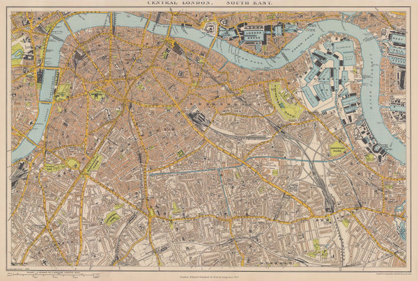
Edward Stanford, Central London, North West, 1904£ 745.00


Page
105
of 131