-
 Edward Stanford, Ancient Greece with Thessaly, 1904£ 75.00
 -
Rand, McNally & Co., Colorado, 1904£ 395.00
-
Edward Stanford, Cyprus, 1904£ 68.00
-
George Philip & Son Ltd., Limehouse, Poplar, Stepney, Rotherhithe & Canary Wharf, 1904£ 65.00
-
Edward Stanford, Thebes, 1904£ 58.00
-
George Philip & Son Ltd., Woolwich, 1904£ 55.00
-
George Philip & Son Ltd., Stratford, Leytonstone & Wanstead Flats, 1904£ 50.00
-
George Philip & Son Ltd., Canning Town, Blackwall, Victoria Dock & Silvertown, 1904£ 65.00
-
Streatham Hill, Tooting Common, Tulse Hill & Brixton Hill, 1904George Philip & Son Ltd.Series: LondonGeorge Philip & Son Ltd., Streatham Hill, Tooting Common, Tulse Hill & Brixton Hill, 1904£ 65.00
-
George Philip & Son Ltd., Barking & East Ham, 1904£ 55.00
-
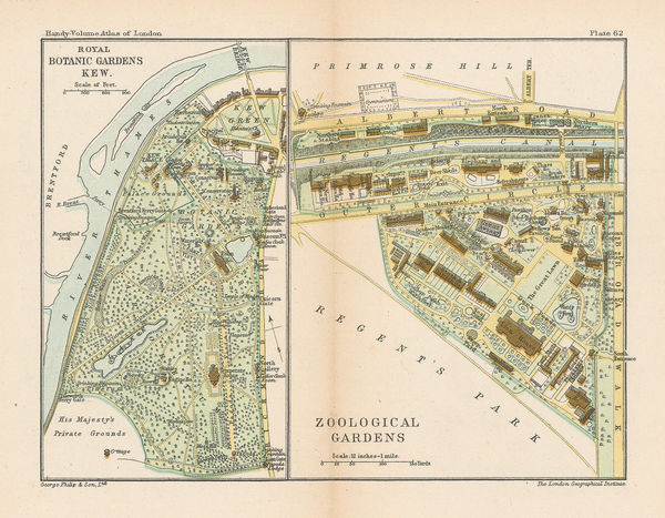
George Philip & Son Ltd., Kew Gardens & London Zoo, 1904£ 58.00
-
George Philip & Son Ltd., Kew, Richmond, Twickenham, Kingston & Hampton Court, 1904£ 68.00
-
George F. A. Mulock, Scott's Map of the Ross Barrier Ice Shelf, 1904£ 2,750.00
-
Edward Stanford, Constantinople (Istanbul), 1904£ 145.00
-
George Philip & Son Ltd., Wimbledon, 1904£ 74.00
-
Royal Geographical Society (RGS), The New Zealand Lakes, 1904£ 495.00
-
Karl Baedeker, Savannah, 1904£ 68.00
-
Anguilla to Puerto Rico shewing the Approaches to the Virgin Islands, 1905British AdmiraltySeries: LondonBritish Admiralty, Anguilla to Puerto Rico shewing the Approaches to the Virgin Islands, 1905£ 3,000.00
-
Bathymetrical Survey of the South Atlantic Ocean and Weddell Sea, 1905Scottish Geographical Society (SGS)Series: EdinburghScottish Geographical Society (SGS), Bathymetrical Survey of the South Atlantic Ocean and Weddell Sea, 1905£ 1,250.00
-
George F. A. Mulock, Robert Falcon Scott's Discovery Expedition, 1905£ 2,850.00
-
Scottish Geographical Society (SGS), Congo Free State, 1905£ 175.00
-
Scottish Geographical Society (SGS), Congo Free State, 1905£ 225.00
-
Deep Sea Deposits of the South Atlantic Ocean and Weddell Sea, 1905Scottish Geographical Society (SGS)Series: EdinburghScottish Geographical Society (SGS), Deep Sea Deposits of the South Atlantic Ocean and Weddell Sea, 1905£ 950.00
-
Hans Krämer, Near Side of the Moon, 1905£ 275.00
-
Geographical Section, General Staff (GSGS), Kilimanjaro, 1905£ 895.00
-
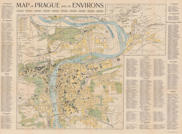
Charles Bellmann, Prague, 1905£ 325.00
-
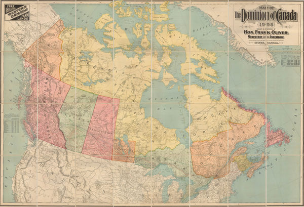
Frank Oliver, Map of the Dominion of Canada, 1905£ 3,950.00
-
General Land Office (GLO), Map of the Territory of Hawaii, 1905£ 885.00
-
Scottish National Antarctic Expedition - Map showing the track of the "Scotia", 1903-1904, 1905Scottish Geographical Society (SGS)Series: EdinburghScottish Geographical Society (SGS), Scottish National Antarctic Expedition - Map showing the track of the "Scotia", 1903-1904, 1905£ 1,800.00
-
Royal Geographical Society (RGS), Sketch Map of the Republic of Liberia, 1905£ 245.00
-
Sketch map to Illustrate the paper by Dr. Charcot on the French Antarctic Expedition, 1905Royal Geographical Society (RGS)Series: LondonRoyal Geographical Society (RGS), Sketch map to Illustrate the paper by Dr. Charcot on the French Antarctic Expedition, 1905£ 950.00
-
George F. A. Mulock, Sledge Journeys from Winter Quarters, 1905£ 2,850.00
-
Royal Geographical Society (RGS), Uganda - Tanzania Border Commission, 1905£ 145.00
-
Tibet, Map showing Explorations by Major C. H. D. Ryder RE DSO and Captains H. Wood RE & H. W. Cowie RE of the Tibet Frontier Commission 1904, 1905Royal Geographical Society (RGS)Series: LondonRoyal Geographical Society (RGS), Tibet, Map showing Explorations by Major C. H. D. Ryder RE DSO and Captains H. Wood RE & H. W. Cowie RE of the Tibet Frontier Commission 1904, 1905£ 375.00
-
United States Geological Survey (USGS), Two-Sheet Chart of Nantucket, 1905£ 525.00
-
De Dion-Bouton, Automobile Racing through the Pyrenees, 1905£ 395.00
-
Royal Geographical Society (RGS), Plan of Lhasa, 1905£ 295.00
-
The Territories of the Maharaja of Jummoo and Kashmir, 1905 (c.)Thacker, Spink & Co.Series: CalcuttaThacker, Spink & Co., The Territories of the Maharaja of Jummoo and Kashmir, 1905 (c.)£ 375.00
-
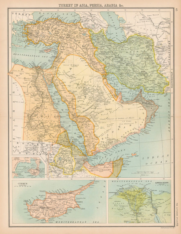
John Bartholomew & Co., Turkey in Asia, Arabia, Persia &c., 1905 (c.)£ 245.00
-
George W. Bacon, Oxford, 1905 (c.)£ 525.00
-
Officine "Chiattone", Lakes Como, Lugano & Maggiore, 1905 (c.)£ 250.00
-
George W. Bacon, West and Northwest London, 1905 c£ 595.00
-
George W. Bacon, Bacon's Large-Print Map of London and Suburbs, 1905 c£ 575.00
-
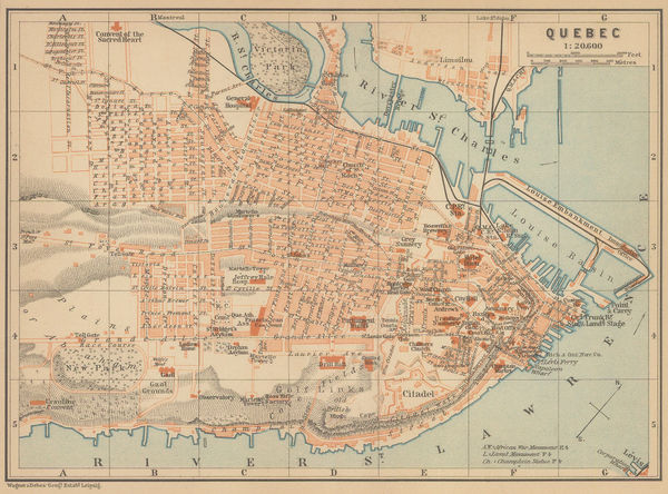
Karl Baedeker, Quebec City, 1905 c.£ 48.00
-
Ernst Schotte & Co, Schottes Schul- & Familien-Globus, 1905 c.£ 3,500.00
-
J.G. Bartholomew, London, 1905 c.£ 395.00
-
Royal Geographical Society (RGS), Iraq, Syria, Armenia and eastern Turkey, 1906£ 325.00
-
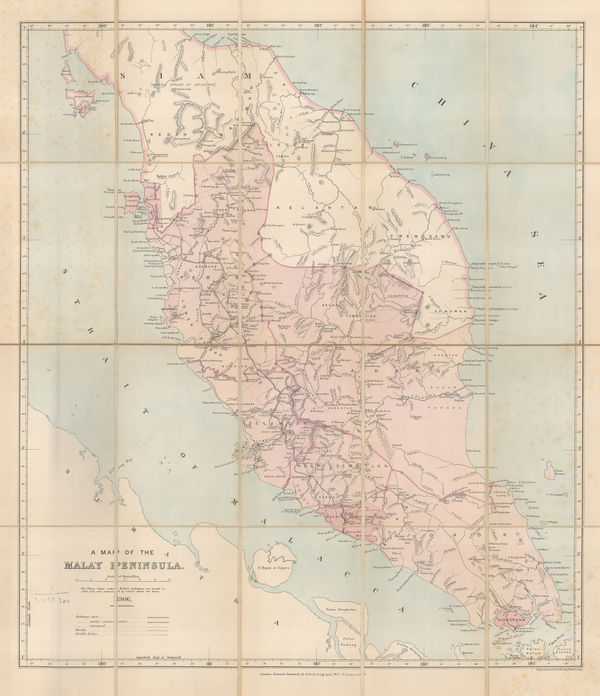
Edward Stanford, A Map of the Malay Peninsula, 1906£ 1,250.00
-
Canadian Government, Map of natural resource of Canada, 1906£ 445.00
-
James White, Ethnographic map of Ontario and Quebec, 1906£ 225.00
-
J.G. Bartholomew, Rubber Growing Countries, 1906£ 125.00
-
Geographical Publishing Co., Intermediate Series: United States, 1906£ 575.00
-
Weller & Grahams Ltd., Map of the Transvaal Colony, 1906£ 245.00
-
Julius Bien, Panama Canal, 1906£ 1,450.00
-
Map to Illustrate the Physical Features of the Transvaal, 1906Royal Geographical Society (RGS)Series: LondonRoyal Geographical Society (RGS), Map to Illustrate the Physical Features of the Transvaal, 1906£ 145.00
-
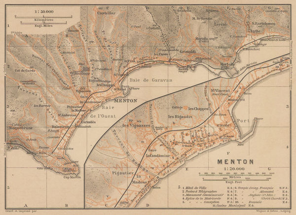
Karl Baedeker, Menton, 1906£ 36.00
-
Hawaiian Government Survey, Oahu - Hawaiian Islands, 1906£ 4,450.00
-
Rand, McNally & Co., Oklahoma and Indian Territory, 1906£ 175.00
-
J.G. Bartholomew, States and British Representation, 1906£ 345.00
-
Rand, McNally & Co., Texas, 1906£ 495.00
-
Royal Geographical Society (RGS), The Southern Japanese Alps, 1906£ 245.00
-
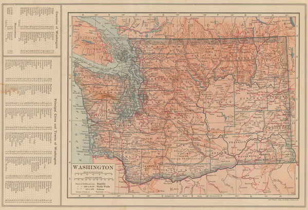
Dodd, Mead & Co., Washington, 1906£ 95.00
-
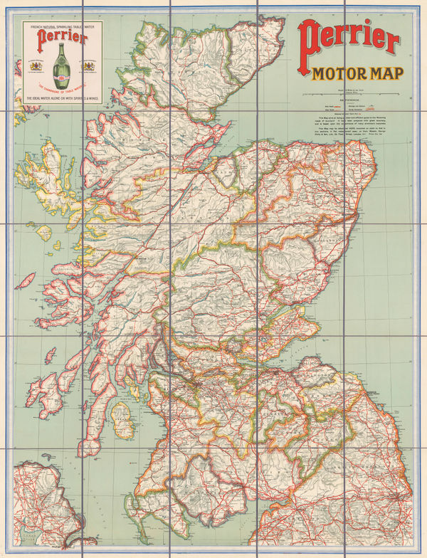
George Philip & Son Ltd., Perrier Motor Map of Scotland, 1906£ 400.00
-
C. N. Hoover, Map of the City of Denver, 1906£ 950.00
-
Royal Geographical Society (RGS), Indian Ocean, 1906£ 195.00
-
George Philip & Son Ltd., Perrier Motor Map of England & Wales, 1906 (c.)£ 295.00
-
W. & A.K. Johnston, The World on Mercator's Projection, 1906 (c.)£ 2,200.00
-
Bathymetrical Chart of North Polar Seas by Dr.Fridtjof Nansen, 1907Royal Geographical Society (RGS)Series: LondonRoyal Geographical Society (RGS), Bathymetrical Chart of North Polar Seas by Dr.Fridtjof Nansen, 1907£ 185.00
-
George Bradshaw, Brussels (Bruxelles), 1907£ 145.00
-
Karl Baedeker, Cannes, 1907£ 44.00
-
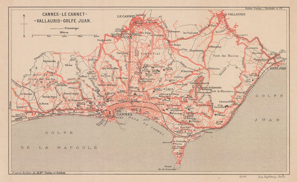
Eugène Dufrenoy, Cannes and environs, 1907£ 68.00
-
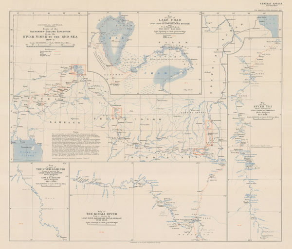
Across Central Africa from Nigeria to the Red Sea, 1907Royal Geographical Society (RGS)Series: LondonRoyal Geographical Society (RGS), Across Central Africa from Nigeria to the Red Sea, 1907£ 195.00
-
Royal Geographical Society (RGS), Central Asia - Leh to Peking, 1907£ 445.00
-
Royal Geographical Society (RGS), China - Routes and Rivers in An-Hui, 1907£ 225.00
-
Cutch and the Ran showing the Mount of the Indus, 1907Royal Geographical Society (RGS)Series: LondonRoyal Geographical Society (RGS), Cutch and the Ran showing the Mount of the Indus, 1907£ 295.00
-
Ordnance Survey, Geological Survey of England and Wales, 1907£ 120.00
-
Ordnance Survey, Geological Survey of England and Wales Sheet 18 & Part of 17, 1907£ 150.00
-
Map Showing Indian Reservations within the Limits of the United States, 1907Francis Ellington LeuppSeries: Washington, D.C.Francis Ellington Leupp, Map Showing Indian Reservations within the Limits of the United States, 1907£ 945.00
-
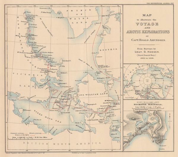
Roald Amundsen's Gjøa Expedition through the Northwest Passage, 1907Royal Geographical Society (RGS)Series: LondonRoyal Geographical Society (RGS), Roald Amundsen's Gjøa Expedition through the Northwest Passage, 1907£ 395.00
-
Royal Geographical Society (RGS), Eastern Zambia, 1907£ 175.00


Page
106
of 131