-
 George Philip & Son Ltd., Part of Orange Free State Province, 1914£ 48.00
 -
Part of the North-Eastern Frontier and Tibet showing the routes of Captains Morshead and Bailey 1913, 1914Royal Geographical Society (RGS)Series: LondonRoyal Geographical Society (RGS), Part of the North-Eastern Frontier and Tibet showing the routes of Captains Morshead and Bailey 1913, 1914£ 285.00
-
Regional Map Showing the Area Covered by the Australasian Antarctic Expedition, 1914Royal Geographical Society (RGS)Series: LondonRoyal Geographical Society (RGS), Regional Map Showing the Area Covered by the Australasian Antarctic Expedition, 1914£ 795.00
-
Sketch Map to illustrate the paper by Raymond E. Priestly on The Work of the Northern Party, 1914Royal Geographical Society (RGS)Series: LondonRoyal Geographical Society (RGS), Sketch Map to illustrate the paper by Raymond E. Priestly on The Work of the Northern Party, 1914£ 675.00
-
Southern Provinces of Nigeria - The Eket District, 1914Royal Geographical Society (RGS)Series: LondonRoyal Geographical Society (RGS), Southern Provinces of Nigeria - The Eket District, 1914£ 145.00
-
-
-
-
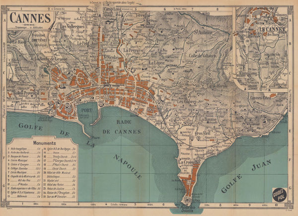
E. Fonne, Cannes, 1914£ 250.00
-
Karl Baedeker, Valladolid, 1914£ 55.00
-
E. Fonne, Ajaccio, 1914£ 55.00
-
E. Fonné, Menton, 1914£ 68.00
-
E. Fonne, Monaco, 1914£ 345.00
-
George Philip & Son Ltd., Chart of the Panama Canal, 1914 c.£ 495.00
-
Clason Map Co., Clason's Guide Map of Washington, 1914 c.£ 195.00
-
Editions-G.D., WWI French caricature map of Europe, 1915£ 4,500.00
-
Indian Reservations in the United States, 1915, 1915United States Geological Survey (USGS)Series: Washington, D.C.United States Geological Survey (USGS), Indian Reservations in the United States, 1915, 1915£ 525.00
-
War Office, Marsabit, Northern Kenya, 1915£ 395.00
-
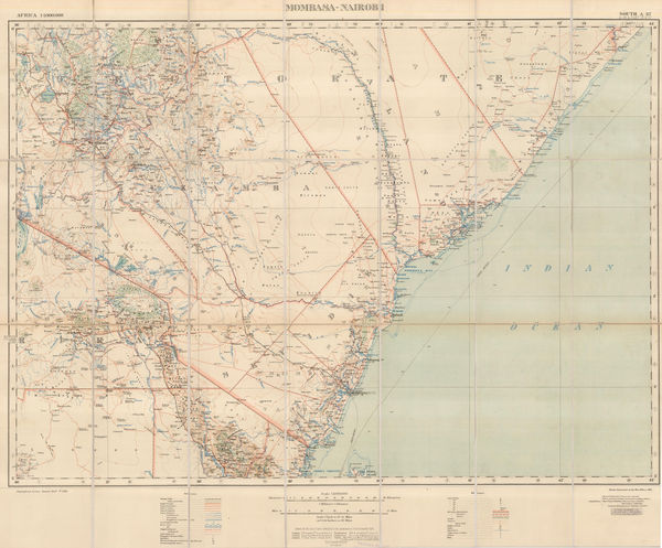
War Office, Kenya from Mombasa to Nairobi, 1915£ 695.00
-
Royal Geographical Society (RGS), Routes Through Barga and North Eastern Mongolia, 1915£ 155.00
-
Royal Geographical Society (RGS), The Geography of the War, 1915£ 125.00
-
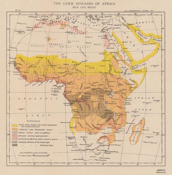
Royal Geographical Society (RGS), The Germ Diseases of Africa: Man and Beast, 1915£ 145.00
-
Royal Geographical Society (RGS), The Mineral and Vegetable Values of Africa, 1915£ 125.00
-
The Political map of Africa in July 1914 | Africa as it Might Have been in 1916 | Africa as it May be when the War is Finished., 1915Royal Geographical Society (RGS)Series: LondonRoyal Geographical Society (RGS), The Political map of Africa in July 1914 | Africa as it Might Have been in 1916 | Africa as it May be when the War is Finished., 1915£ 950.00
-
War Office, Southern Iraq from Baghdad to the Persian Gulf, 1915£ 1,250.00
-
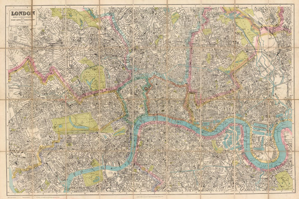
Thomas Kelly, London, 1915£ 545.00
-
Wm. C. Gentry, North-East Kent, 1915 (c.)£ 295.00
-
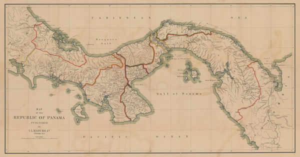
I.L. Maduro Jr., Map of the Republic of Panama, 1915 c.£ 775.00
-
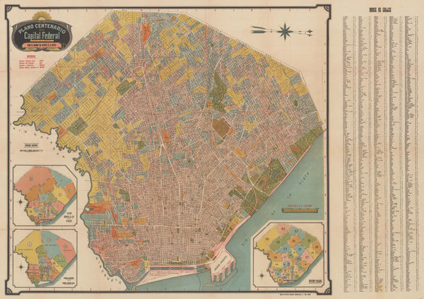
A. Bemporat, Wall map of Buenos Aires, 1915 c.£ 975.00
-
George Philip & Son Ltd., Glasgow, 1915 c.£ 68.00
-
John Bartholomew & Son, South Polar Regions, 1915 c.£ 95.00
-
John Bartholomew & Son, North Polar Regions, 1915 c.£ 65.00
-
C.N. Caspar & Co., Caspar's Official Map of the City of Milwaukee and Vicinity, 1916£ 595.00
-
James Perrin Smith, Geological Map of California, 1916£ 4,000.00
-
D.G. Hatchell, Malabar District Map for the use of Touring Officers, 1916£ 495.00
-
Royal Geographical Society (RGS), Railway map of Africa, 1916£ 485.00
-
The Graphic Magazine, WWI - the Battle of Verdun, 1916£ 125.00
-
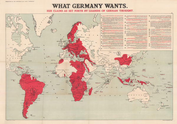
Edward Stanford, What Germany Wants, 1916£ 1,650.00
-
London Underground, Underground Map of London with some Motor Bus Extensions, 1916£ 625 (framed)
-
Royal Geographical Society (RGS), Map of Rhodesia, 1916£ 425.00
-
Royal Geographical Society (RGS), Eurasia Commercial Development, 1917£ 95.00
-
Royal Geographical Society (RGS), Geological Map of New Caledonia, 1917£ 285.00
-
War Office, Lake Victoria, 1917£ 595.00
-
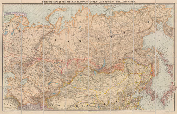
Edward Stanford, Trans-Siberian Railway, 1917£ 1,250.00
-
British Admiralty, Turks Islands, 1917£ 945.00
-
Survey of India, India and Adjacent Countries - Baroda, 1917£ 795.00
-
G. Delattre & Cie., First World War French propaganda poster, 1917 c.£ 825.00
-
Official Tourist Bureau (OTB), Vintage tourist map of Java, 1918£ 165.00
-
Brady Standard Print, McCulloch County Texas, 1918£ 885.00
-
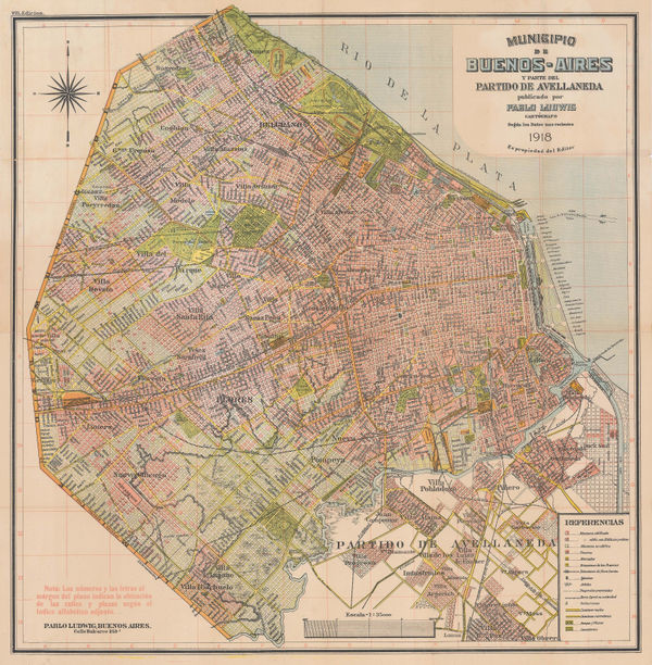
Pablo Ludwig, Municipality of Buenos Aires, 1918£ 1,450.00
-
Railway Clearing House, Official Railway Map of the West of England, 1918£ 395.00
-
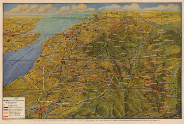
Otto Kurth, WWI - Western Front in September, 1918, 1918£ 250.00
-
Geographical Section, General Staff (GSGS), Iraq, Iran & Kuwait, 1918£ 2,850.00
-
Royal Geographical Society (RGS), East Africa, 1918£ 525.00
-
Edward Stanford, Cairo, 1918£ 75.00
-
George W. Bacon, New Map of the Cape Peninsula, 1918 c.£ 925.00
-
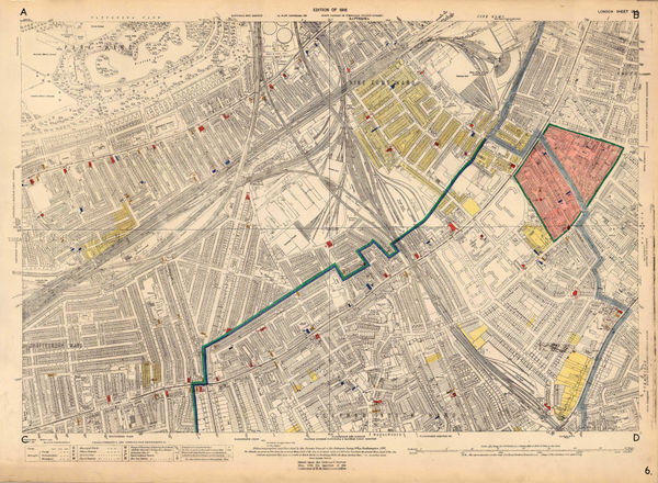
Ordnance Survey, Nine Elms, 1918 c.£ 850.00
-
Ordnance Survey, Heligoland 28th August 1914 General Chart of the Action, 1919£ 225.00
-
Indian Reservations West of the Mississippi River, 1919United States Geological Survey (USGS)Series: Washington, D.C.United States Geological Survey (USGS), Indian Reservations West of the Mississippi River, 1919£ 975.00
-
J.C. Juta & Co., Plan of Cape Town, 1919£ 1,950.00
-
Australian Survey Co, Western Australia - Perth, 1919£ 1,250.00
-
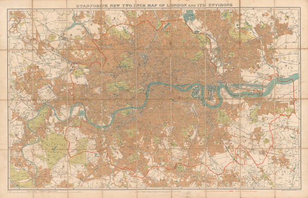
Edward Stanford, Stanford's New Two Inch Map of London and Its Environs, 1919£ 975.00
-
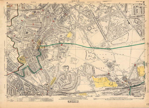
Ordnance Survey, Blackheath, 1919 c.£ 775.00
-
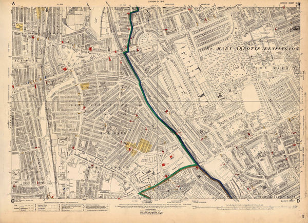
Ordnance Survey, Holland Park to Shepherds Bush, 1919 c.£ 1,350.00
-
Louis Gentil, Geological map of Morocco, 1920£ 945.00
-
W.C.S. Ingles, Motoring map of Sri Lanka (Ceylon), 1920£ 750.00
-
Ordnance Survey, Canterbury, 1920£ 195.00
-
Ordnance Survey, York, 1920£ 275.00
-
Alexander Gross, Commercial & Political Map of the World, 1920£ 4,950.00
-
John Murray, Fort of Gwalior, 1920£ 38.00
-
Ordnance Survey, Geological Survey of England and Wales, 1920£ 150.00
-
John Murray, Lucknow Intrenched Position of the British Garrison, 1920£ 48.00
-
Harrison & Eaton, Map of Ranger-Strawn-Stephens Co. Area, 1920£ 4,500.00
-
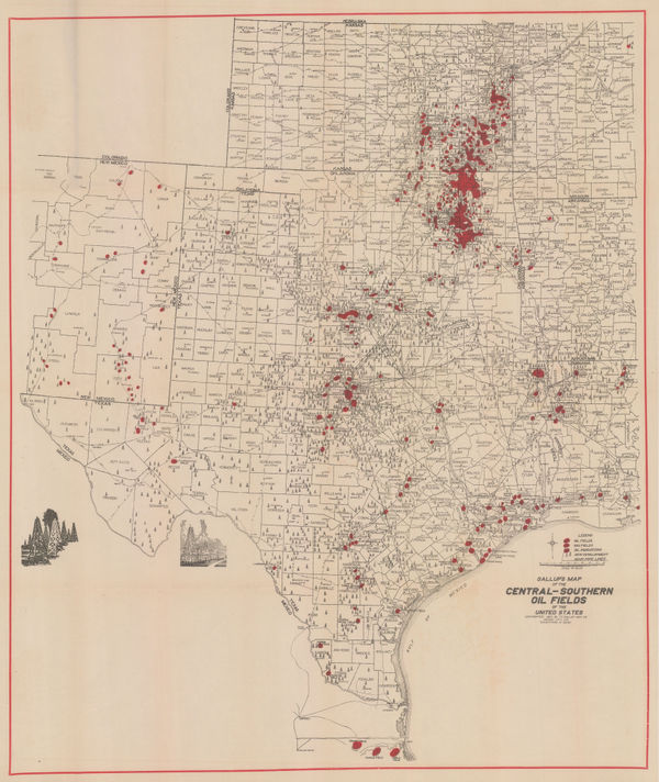
F.E. Gallup, Map of the Central-Southern Oil Fields, 1920£ 3,450.00
-
Map of the Petrolia Gas Fields Texas, 1920United States Geological Survey (USGS)Series: Washington, D.C.United States Geological Survey (USGS), Map of the Petrolia Gas Fields Texas, 1920£ 445.00
-
Africa showing British possessions at their height, 1920Royal Geographical Society (RGS)Series: LondonRoyal Geographical Society (RGS), Africa showing British possessions at their height, 1920£ 345.00
-
Edward Stanford, Eastern Brazil, 1920£ 295.00
-
Relief Map of the Territory Served by the Lines of the Pacific Electric Railway in Southern California, 1920O.A. SmithO.A. Smith, Relief Map of the Territory Served by the Lines of the Pacific Electric Railway in Southern California, 1920£ 950.00
-
Survey of India, The Himalaya Mountains and Surrounding Regions, 1920£ 4,450.00
-
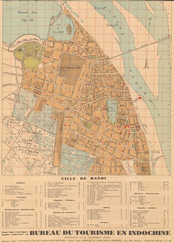
Anonymous, Hanoi, 1920£ 1,650.00


Page
112
of 131