-
 Edward Stanford, Brentford & Kew Gardens, 1920£ 42.00
 -
Fred Wild Company, Chicago, 1920£ 850.00
-
George Philip & Son Ltd., India, 1920 (c.)£ 275.00
-
George W. Bacon, Plan of the Borough of Sunderland, 1920 (c.)£ 125.00
-
Finland Travel Bureau, Helsinki, 1920 (c.)£ 145.00
-
John Bartholomew & Co., Skye, 1920 (c.)£ 375.00
-
G. Thomas, 8-inch Globe Terrestre, 1920 (c.)£ 650.00
-
George Philip & Son Ltd., Commercial Map of the Indian Empire, 1920 (c.)£ 2,500.00
-
George W. Bacon, Halifax, West Yorkshire, 1920 (c.)£ 150.00
-
George W. Bacon, Nightingale's New Library & Route Chart of the World, 1920 (c.)£ 1,450.00
-
George W. Bacon, Plan of Belfast, 1920 c£ 450.00
-
Robert & Cie, Vintage road map of Corsica, 1920 c£ 495.00
-
George Philip & Son Ltd., Strategic Record Map of the Western Front, 1920 c£ 345.00
-
Ordnance Survey, Map of the Parish of Hammersmith, 1920 c£ 325.00
-
A. C. Braby, Map of Natal and Zululand, 1920 c£ 650.00
-
Canadian Pacific Railway, Railway map of the Canadian Rocky Mountains, 1920 c£ 485.00
-
Alexander Nicohosoff, A New Map of Cairo and Environs, 1920 c£ 345.00
-
Alexander Gross, North West India, Pakistan & Afghanistan, 1920 c£ 425.00
-
George W. Bacon, Leeds, 1920 c.£ 295.00
-
Brett's Pharmacy, Tourist guide of Yokohama, 1920 c.£ 145.00
-
Harmsworth, Dixmude to Arras, 1920 c.£ 44.00
-
Anonymous, Eastern District of Victoria City, 1920 c.£ 445.00
-
George W. Bacon, Bournemouth, 1920 c.£ 325.00
-
Pharus, Leeds, 1920 c.£ 650.00
-
Harmsworth, Lens and Arras, 1920 c.£ 42.00
-
Map Showing the Position of the Rubber Estates in South India and Ceylon, 1920 c.The Financial TimesSeries: LondonThe Financial Times, Map Showing the Position of the Rubber Estates in South India and Ceylon, 1920 c.£ 495.00
-
Service Géographique de l'Armée, Relief map of Morocco, 1920 c.£ 250.00
-
Rand, McNally & Co., New Commercial Atlas Map of Minnesota, 1920 c.£ 345.00
-
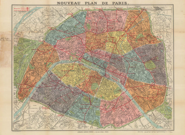
Garnier Frères, Railway map of Paris, 1920 c.£ 195.00
-
George W. Bacon, Portsmouth, 1920 c.£ 295.00
-
George W. Bacon, Scarborough, 1920 c.£ 325.00
-
George W. Bacon, Tunbridge Wells, 1920 c.£ 195.00
-
Clason Map Co., Prospector's Guide of Colorado, 1920 c.£ 425.00
-
Pharus, Tallinn (Reval), 1920 c.£ 375.00
-
Kummerly & Frey, Switzerland, 1920 c.£ 125.00
-
Anonymous, Western District of Victoria City, 1920 c.£ 445.00
-
Harmsworth, Western Front (British and German Attacks), 1920 c.£ 75.00
-
Harmsworth, Western Front - Cambrai and Bourlon Wood, 1920 c.£ 58.00
-
Jules Chaure, Tourist Map of Casablanca, Morocco, 1920 c.£ 445.00
-
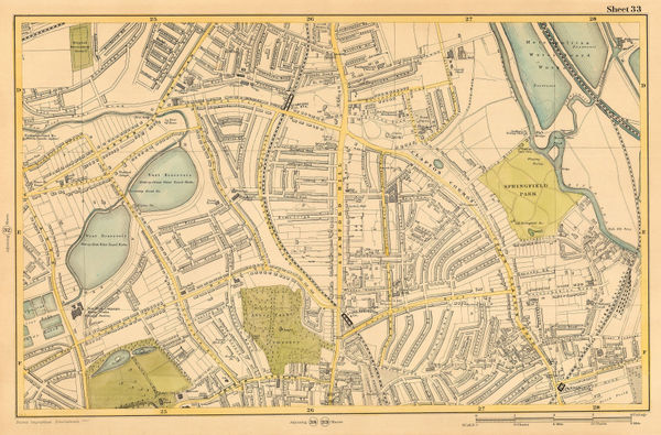
George W. Bacon, Manor House, Abney Park, Stoke Newington & Clapton, 1920 c.£ 88.00
-
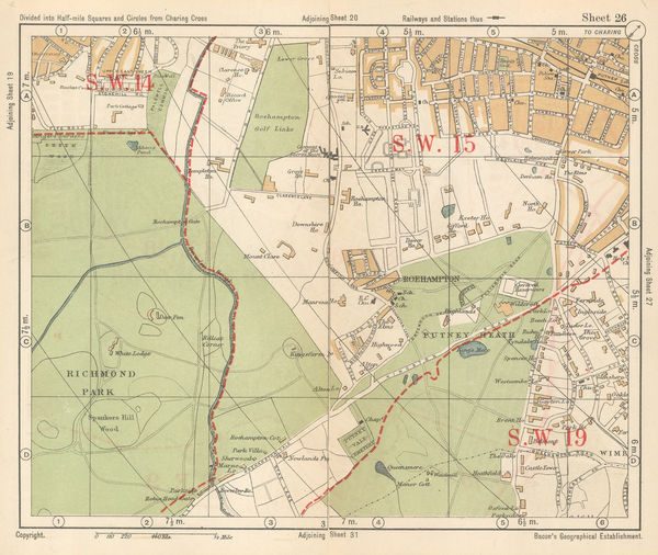
George W. Bacon, Richmond Park & Putney Heath, 1920 c.£ 36.00
-
-
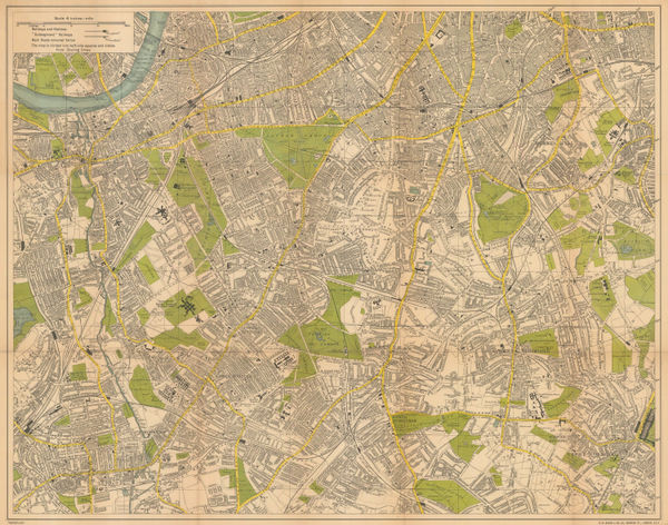
George W. Bacon, South London, 1920 c.£ 425.00
-
George W. Bacon, Cardiff, Penarth & Llandaff, 1920 c.£ 295.00
-
Harmsworth, Western Front : Loos and Hohenzollern Redoubt, 1920 c.£ 68.00
-
George W. Bacon, Eastbourne, 1920 c.£ 95.00
-
Rand, McNally & Co., New Commercial Atlas Map of Arkansas, 1920 c.£ 245.00
-
Benito Chias, The Balearic Islands, 1920 c.£ 325.00
-
Ordnance Survey, South London, Kent & East Sussex, 1920 c.£ 450.00
-
A. Trüb & Cie, Interlaken & Environs - Wengen, 1920 c.£ 295.00
-
Harmsworth, Battle of the Somme, 1920 c.£ 86.00
-
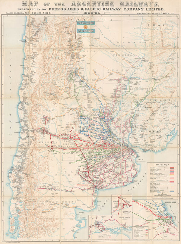
Waterlow & Sons, Railway Map of Argentina, 1921£ 1,350.00
-
Geographical Section, General Staff (GSGS), Persia (Iran) and Afghanistan, 1921£ 375.00
-
Australian Survey Co, Western Australia - Fremantle, 1921£ 1,250.00
-
Ethelbert William Bullinger, XI. Hercules (The Mighty One), 1921£ 85.00
-
X. Serpens Ophiuchus (The Serpent and The Serpent Holder), 1921Ethelbert William BullingerSeries: LondonEthelbert William Bullinger, X. Serpens Ophiuchus (The Serpent and The Serpent Holder), 1921£ 85.00
-
Ethelbert William Bullinger, Coma Berenices, 1921£ 55.00
-
Ethelbert William Bullinger, Corona (the Crown), 1921£ 55.00
-
Ethelbert William Bullinger, Centaurus (the Centaur), 1921£ 65.00
-
Ethelbert William Bullinger, XXVIII. Taurus (the Bull), 1921£ 95.00
-
Ethelbert William Bullinger, XXXVIII. Argo (The Ship), 1921£ 85.00
-
Ethelbert William Bullinger, XII. Sagittarius (the Archer), 1921£ 95.00
-
Ethelbert William Bullinger, Centaurus (the Centaur), 1921£ 65.00
-
Ethelbert William Bullinger, XXXII Gemini (the Twins), 1921£ 95.00
-
Macdonald Gill, Map of Electric Railways of London, 1921£ 1,350.00
-
George W. Bacon, Cairo, 1921£ 650.00
-
Survey Dept. F.M.S., Wall map of the Malaysian Peninsula and Singapore, 1921£ 1,650.00
-
XVII. Sagitta, Aquila, and Delphinus (The Arrow, The Eagle, and The Dolphin), 1921Ethelbert William BullingerSeries: LondonEthelbert William Bullinger, XVII. Sagitta, Aquila, and Delphinus (The Arrow, The Eagle, and The Dolphin), 1921£ 75.00
-
Ethelbert William Bullinger, XX. Cygnus (The Swan), 1921£ 75.00
-
Ethelbert William Bullinger, XIII. Lyra (The Harp), 1921£ 65.00
-
Carl Crow, Plan of Hong Kong, City of Victoria, 1921£ 495.00
-
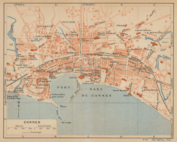
Eugène Dufrenoy, Cannes, 1921£ 58.00
-
Alexander Gross, New Map of Poland, 1921 c£ 350.00
-
Ordnance Survey, Highgate Village, 1921 c.£ 1,250.00
-
John Bartholomew & Co., Inter-war map of Turkey, Iraq, and the Levant, 1922£ 395.00
-
British Admiralty, Chart of the Island of Ceylon with the Adjacent Coast of India, 1922£ 3,450.00
-
Kinosuke Inouye, Map of Applied Geology - Japan - Copper, 1922£ 495.00
-
Kue Shan Is. to the Yang Tse Kiang including the Chusan Archipelago, 1922British AdmiraltySeries: LondonBritish Admiralty, Kue Shan Is. to the Yang Tse Kiang including the Chusan Archipelago, 1922£ 1,450.00
-
British Admiralty, Aegean Sea and Islands, 1922£ 1,450.00
-
John Bartholomew, North Polar Regions, 1922£ 345.00


Page
113
of 131