-
 Istanbul (Constantinople), 1922Société Anonyme Ottomane d'Etudes et d'Enterprises UrbainesSeries: IstanbulSociété Anonyme Ottomane d'Etudes et d'Enterprises Urbaines, Istanbul (Constantinople), 1922£ 950.00
 -
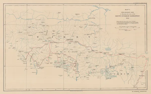
Preliminary Map to Illustrate the Route of the Mount Everest Expedition, 1922Royal Geographical Society (RGS)Series: LondonRoyal Geographical Society (RGS), Preliminary Map to Illustrate the Route of the Mount Everest Expedition, 1922£ 675.00
-
John Bartholomew, South Polar Regions, 1922£ 725.00
-
Royal Geographical Society (RGS), The Geology of the Mount Everest Region, 1922£ 675.00
-
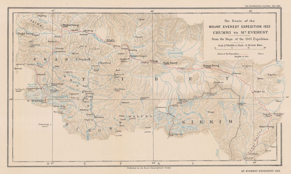
The Route of the Mount Everest Expedition 1922, Chumbi to Mt. Everest from the maps of the 1921 Expedition, 1922Royal Geographical Society (RGS)Series: LondonRoyal Geographical Society (RGS), The Route of the Mount Everest Expedition 1922, Chumbi to Mt. Everest from the maps of the 1921 Expedition, 1922£ 675.00
-
John Bartholomew & Co., Palestine, 1922£ 195.00
-
John Bartholomew, India & Southeast Asia - Political, 1922£ 145.00
-
John Bartholomew & Son, Greece & the Aegean Sea, 1922£ 95.00
-
John Bartholomew & Son, Southwest Africa, 1922£ 125.00
-
J.G. Bartholomew, Middle East, 1922£ 425.00
-
E. W. Gregory, Beijing, 1922£ 1,550.00
-
John Bartholomew & Son, World Commerce Maps, 1922£ 225.00
-
John Bartholomew & Son, World Map of Vegetation and Ocean Currents, 1922£ 175.00
-
John Bartholomew & Son, World Maps throughout History, 1922£ 145.00
-
John Bartholomew & Son, Physical Map of the World with Sea and Land Elevation, 1922£ 145.00
-
John Bartholomew & Son, British Columbia, 1922£ 95.00
-
John Bartholomew & Son, Alberta & Saskatchewan, 1922£ 95.00
-
John Bartholomew & Son, Manitoba & Northwest Ontario, 1922£ 95.00
-
John Bartholomew & Son, Western Canada, 1922£ 95.00
-
J.G. Bartholomew, Southeast Africa, 1922£ 125.00
-
War Office, Riyadh, 1922£ 4,500.00
-
J.G. Bartholomew, Ontario & Quebec, 1922£ 95.00
-
J.G. Bartholomew, South Atlantic Ocean, 1922£ 95.00
-
-
-
J.G. Bartholomew, East Africa, 1922£ 145.00
-
Royal Geographical Society (RGS), Northern Arabia, 1922£ 1,750.00
-
John Bartholomew, Japan & Korea, 1922£ 185.00
-
John Bartholomew & Son, Estonia, Latvia & Lithuania, 1922£ 125.00
-
-
John Bartholomew & Son, Mexico & Central America, 1922£ 125.00
-
John Bartholomew & Son, Dominion of Canada - Political, 1922£ 95.00
-
John Bartholomew & Son, North-Eastern Canada, 1922£ 95.00
-
J.G. Bartholomew, Maritime Provinces and Newfoundland, 1922£ 95.00
-
J.G. Bartholomew, South Africa, 1922£ 125.00
-
Cartes Tarides, Road map of Corsica, 1922 c.£ 145.00
-
George W. Bacon, Nightingale's New Chart of the World, 1922 c.£ 2,250.00
-
British Admiralty, Amoy to Nagasaki, 1923£ 1,350.00
-
William Collins, Arctic Coast of Canada, 1923£ 595.00
-
Kennedy North, British Empire Exhibition 1924, 1923£ 650.00
-
British Admiralty, Rare chart of Taiwan (Formosa) and the Taiwan Strait, 1923£ 3,950.00
-
British Admiralty, Rare and detailed chart of northern Taiwan (Formosa), 1923£ 2,950.00
-
British Admiralty, Gogo Shima to Miyo Shima including Kurushima Kaikyo, 1923£ 495.00
-
-
-
-
British Admiralty, Japan. Naikai or Inland Sea. Izumi Nada and Harima Nada, 1923£ 495.00
-
British Admiralty, Japan. Shimonoseki Kaikyo, 1923£ 495.00
-
British Admiralty, Kiaochow Bay, 1923£ 985.00
-
-
British Admiralty, Malacca Straits, 1923£ 1,150.00
-
Richard Anthony Proctor, Stars for February & March, 1923£ 95.00
-
Geographical Section, General Staff (GSGS), Bannu and Dera Ismail Khan Divisions, 1923£ 545.00
-
Map of the North Polar Regions for "A Naturalist at the Poles", 1923John BartholomewSeries: EdinburghJohn Bartholomew, Map of the North Polar Regions for "A Naturalist at the Poles", 1923£ 195.00
-
Map of the South Polar Regions for "A Naturalist at the Poles", 1923John BartholomewSeries: EdinburghJohn Bartholomew, Map of the South Polar Regions for "A Naturalist at the Poles", 1923£ 975.00
-
Motor and camel Surveys in the North Arabian Desert, 1923Royal Geographical Society (RGS)Series: LondonRoyal Geographical Society (RGS), Motor and camel Surveys in the North Arabian Desert, 1923£ 165.00
-
British Admiralty, Ozuchi Jima to Funoka Sima, 1923£ 495.00
-
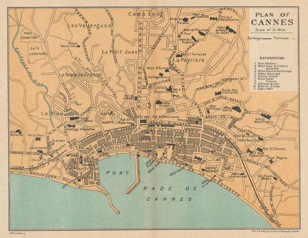
W. & A.K. Johnston, Plan of Cannes, 1923£ 52.00
-
James Reynolds, Reynolds's New Chart of the Thames Estuary, 1923£ 265.00
-
British Admiralty, The Brothers to Ockseu Is., 1923£ 1,950.00
-
William Olsen, Washington - The Beautiful Capital of the Nation, 1923£ 1,450.00
-
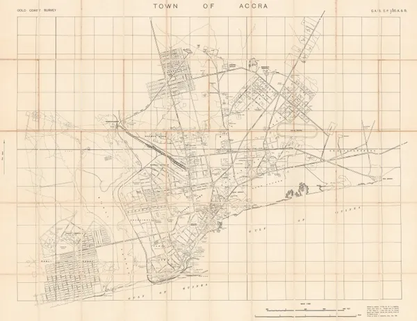
R. H. Rowe, Town of Accra, Ghana, 1923£ 575.00
-
-
Ordnance Survey, Belfast, 1923£ 485.00
-
W. & A.K. Johnston, Plan of Monaco, 1923£ 145.00
-
Richard Anthony Proctor, Stars for January & February, 1923£ 95.00
-
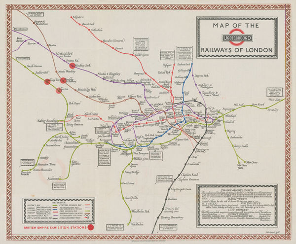
Macdonald Gill, Map of the Underground Railways of London, 1923£ 1,650 (framed)
-
Japanese Railways, Nanjing, 1923£ 125.00
-
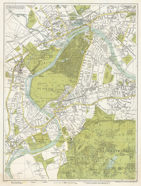
Geographia Ltd., Kew, Richmond, Brentford & Twickenham, 1923£ 250.00
-
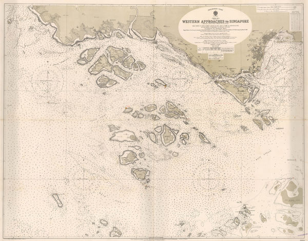
British Admiralty, Singapore Sea Chart, 1924£ 3,250.00
-
Ordnance Survey, Geological Map of the British Isles, 1924£ 885.00
-
Nic Tengg, Map of the City of San Antonio, 1924£ 2,250.00
-
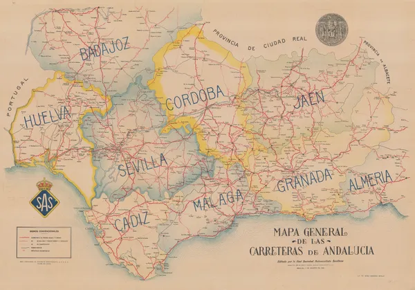
José María Piñar y Pickman, Vintage road map of Andalucia, 1924£ 275.00
-
Service Géographique de l'Armée, Southern Morocco, 1924£ 225.00
-
James Imray, Mouth of the River Thames, 1924£ 525.00
-
Rand, McNally & Co., Plan of Mexico City, 1924£ 975.00
-
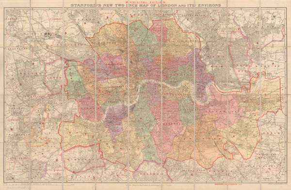
Edward Stanford, Stanford's New Two Inch Map of London and its Environs - Municipal Edition, 1924£ 845.00
-
Ministère des Colonies, Rare folding map of Rwanda and Burundi, 1924£ 950.00
-
V. Neubert, Prague, 1924£ 125.00
-
Eugène Dufrenoy, Casablanca, 1924£ 65.00


Page
114
of 131