-
 Eugène Dufrenoy, Rabat, 1924£ 65.00
 -
Royal Geographical Society (RGS), Air Mosaic of Petra, 1924£ 275.00
-
Eugène Dufrenoy, Marrakesh, 1924£ 65.00
-
Waterlow & Sons, Underground Map of London, 1924£ 750.00
-
Eugène Dufrenoy, Fez, 1924£ 65.00
-
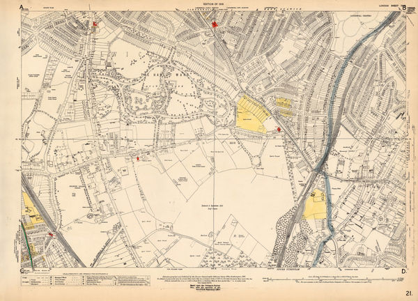
Ordnance Survey, Dulwich, 1924 c.£ 425.00
-
George Philip & Son Ltd., Philip's 12 Inch Library Globe, 1924 c.£ 4,950.00
-
Macdonald Gill, The Wonderground Map of London, 1924 c.£ 4,800 (framed)
-
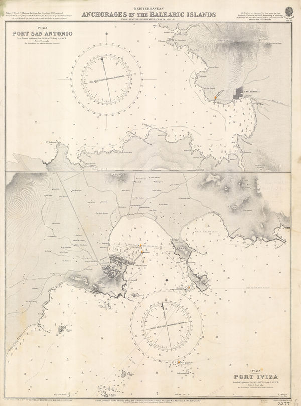
British Admiralty, Anchorages in the Balearic Islands, 1925£ 925.00
-
Arabia - Routes between 'Oqair and Jabrin Oasis in Eastern Nejd, 1925Royal Geographical Society (RGS)Series: LondonRoyal Geographical Society (RGS), Arabia - Routes between 'Oqair and Jabrin Oasis in Eastern Nejd, 1925£ 825.00
-
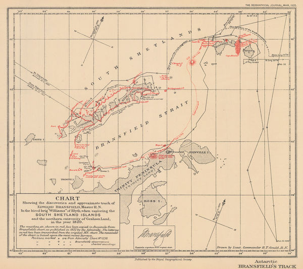
Royal Geographical Society (RGS), South Shetland Islands, 1925£ 850.00
-
Survey of India, Kolkata (Calcutta), 1925£ 825.00
-
Ordnance Survey, Geological Survey of England and Wales, 1925£ 120.00
-
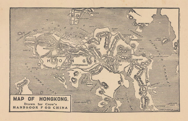
Carl Crow, Map of Hongkong, 1925£ 345.00
-
J.C. Betts, Underground Railways of London, 1925£ 825.00
-
-
Victor Tanasescu, Wall Map of Greater Romania, 1925£ 2,250.00
-
Frederick Chamberlin, Palma de Mallorca, 1925£ 125.00
-
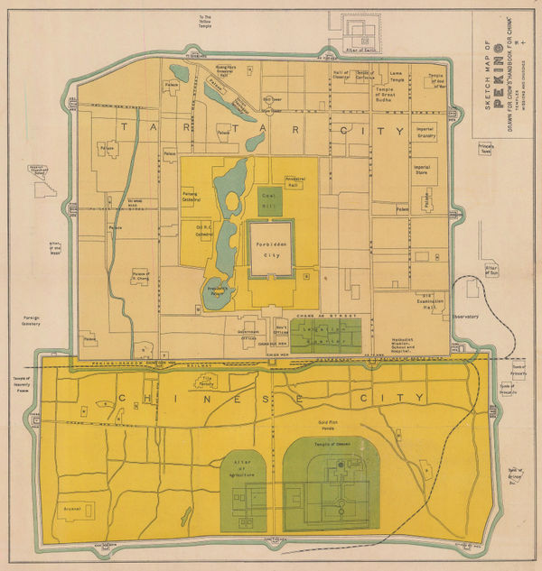
Carl Crow, Sketch Map of Beijing, 1925£ 325.00
-
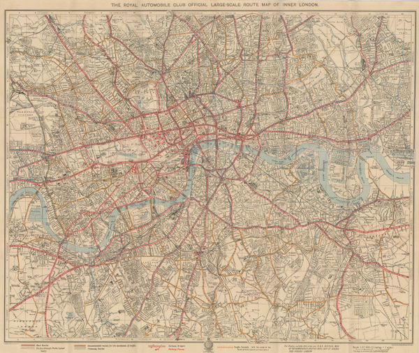
The Royal Automobile Club Official Large Scale Route Map of Inner London, 1925George Philip & Son Ltd.George Philip & Son Ltd., The Royal Automobile Club Official Large Scale Route Map of Inner London, 1925£ 575.00
-
Thomas Cook, Jerusalem, 1925£ 78.00
-
Royal Geographical Society (RGS), Sketch maps of Oman and the UAE, 1925£ 775.00
-
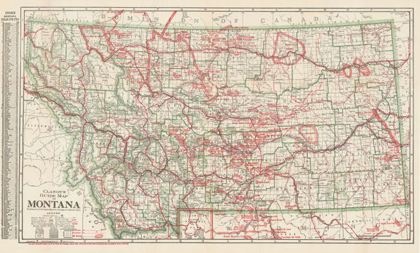
Clason Map Co., Guide Map of Montana, 1925£ 575.00
-
John Truscott, Road Map of Kenya Colony, 1925 (c.)£ 550.00
-
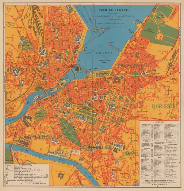
Association des intérêts de Genève, Plan of Geneva, 1925 (c.)£ 145.00
-
Turkish Admiralty, Western Mediterranean, 1925 c£ 275.00
-
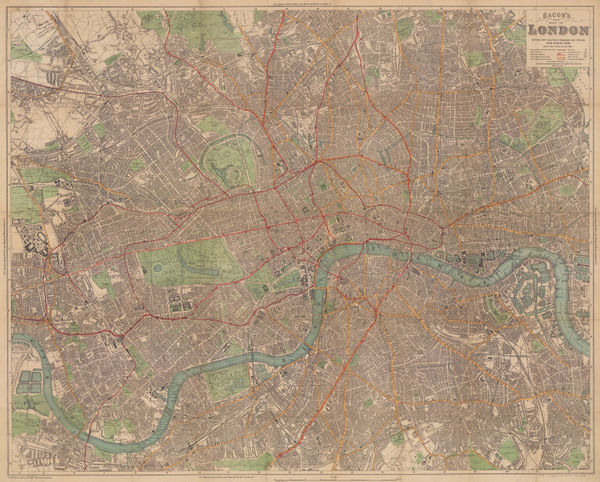
Bacon's New Map of London, Divided into Half-Mile Squares and Circles from Charing Cross, 1925 c.George W. BaconSeries: LondonGeorge W. Bacon, Bacon's New Map of London, Divided into Half-Mile Squares and Circles from Charing Cross, 1925 c.£ 775.00
-
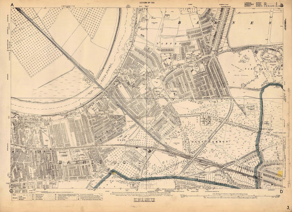
Ordnance Survey, Barnes, 1925 c.£ 1,450.00
-
Edward Stanford, Colombo, 1925 c.£ 68.00
-
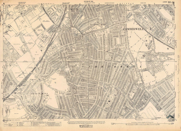
Ordnance Survey, East Dulwich and Camberwell, 1925 c.£ 425.00
-
E. Toutey, Folding wall map of Morocco, 1925 c.£ 975.00
-
Paravia, Vintage city plan of Turin, 1925 c.£ 285.00
-
Alexander Gross, Pictorial Map of the Thames and Medway, 1925 c.£ 945.00
-
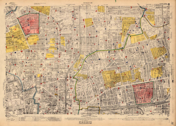
Ordnance Survey, Shoreditch, 1925 c.£ 525.00
-
Edward Stanford, Beaufort Hunt, Gloucestershire, 1925 c.£ 345.00
-
A. Trüb & Cie, Spain and Portugal, 1925 c.£ 750.00
-
Y Koshiba, Geological Map of Japanese Empire, 1926£ 1,550.00
-
Madras Survey, Map of the Madras Presidency Showing the Roads & Distances, 1926£ 950.00
-
Plan of Anuradhapura and Environs shewing Ancient Ruins, 1926Ceylon Survey DepartmentSeries: AnuradhapuraCeylon Survey Department, Plan of Anuradhapura and Environs shewing Ancient Ruins, 1926£ 645.00
-
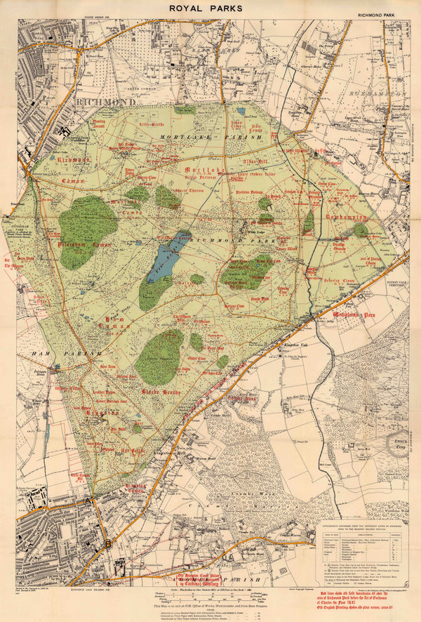
Ordnance Survey, Richmond Park, 1926£ 495.00
-
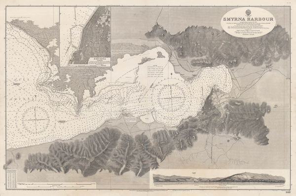
British Admiralty, Smyrna Harbour, 1926£ 985.00
-
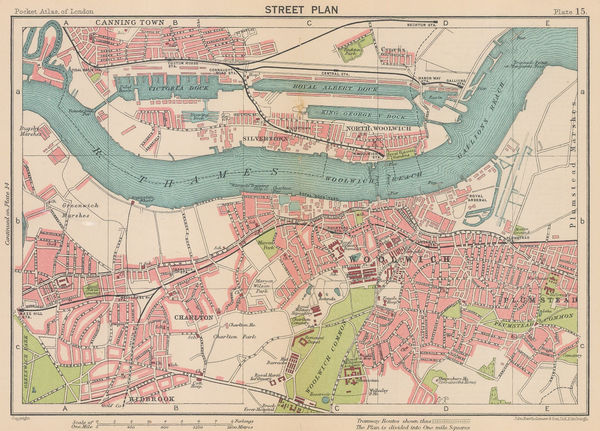
J.G. Bartholomew, Woolwich, Charlton & the Royal Docks, 1926£ 44.00
-
Redfield-Kendrick Odell Co., Sunrise Trails on Long Island, 1926£ 545.00
-
Royal Geographical Society (RGS), Boundaries in East Africa, 1926£ 145.00
-
Cartes Tarides, Vintage folding map of Morocco, 1926 c.£ 545.00
-
Alexander's Campaign on Indian North-West Frontier, 1927Royal Geographical Society (RGS)Series: LondonRoyal Geographical Society (RGS), Alexander's Campaign on Indian North-West Frontier, 1927£ 145.00
-
British Admiralty, Anamba Islands, 1927£ 325.00
-
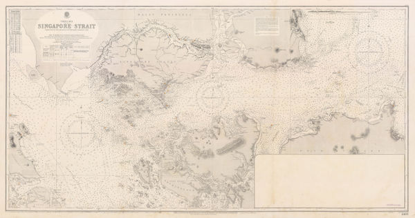
British Admiralty, Singapore Strait Sea Chart, 1927£ 3,950.00
-
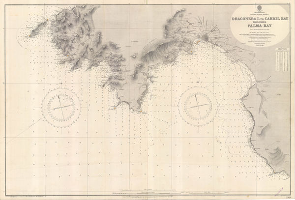
British Admiralty, Dragonera Island to Carril Bay, 1927£ 575.00
-
A. Samler Brown, Fuerteventura and Lanzarote, 1927£ 58.00
-
A. Samler Brown, Gran Canaria, 1927£ 55.00
-
British Admiralty, Guernsey, Herm and Sark, 1927£ 675.00
-
British Admiralty, Island of Jersey, 1927£ 675.00
-
Geographical Section, General Staff (GSGS), Kenya Colony, 1927£ 875.00
-
A. Samler Brown, La Palma, Gomera and Hierro, 1927£ 48.00
-
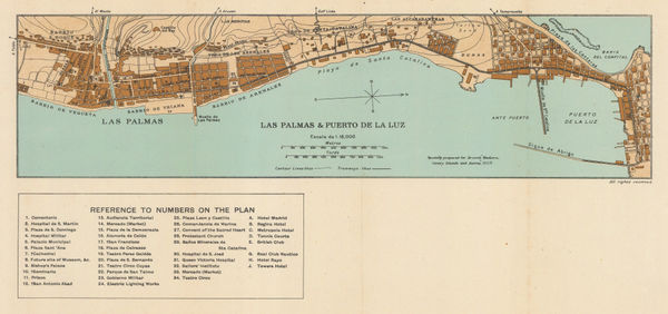
A. Samler Brown, Las Palmas & Puerto De La Luz, 1927£ 45.00
-
Map to Illustrate Major E.W. Nesham's Paper on the Alaska Boundary Demarcation, 1927Royal Geographical Society (RGS)Series: LondonRoyal Geographical Society (RGS), Map to Illustrate Major E.W. Nesham's Paper on the Alaska Boundary Demarcation, 1927£ 85.00
-
British Admiralty, Mediterranean France - South Coast - Approaches to Toulon, 1927£ 225.00
-
British Admiralty, Chart of Sardinia on two sheets, 1927£ 1,250.00
-
-
A. Samler Brown, Tenerife, 1927£ 68.00
-
British Admiralty, Chart of the Port and Harbour of Toulon, 1927£ 295.00
-
Survey of India, Tourist map of Delhi, 1927£ 1,450.00
-
Alberto Martín, Plano de Salamanca, 1927£ 95.00
-
Caucasus: Map Showing the New Political Boundaries, 1927Royal Geographical Society (RGS)Series: LondonRoyal Geographical Society (RGS), Caucasus: Map Showing the New Political Boundaries, 1927£ 195.00
-
Alberto Martín, Plano de Málaga, 1927£ 195.00
-
Alberto Martín, Plano de Toledo, 1927£ 125.00
-
Alberto Martín, Plano de Almería, 1927£ 95.00
-
Alberto Martín, Plano de Cordoba, 1927£ 125.00
-
Alberto Martín, Ciudad de Alicante, 1927£ 95.00
-
Alberto Martín, Plano de Las Palmas de Gran Canaria, 1927£ 245.00
-
Alberto Martín, Santa Cruz, Tenerife, 1927£ 165.00
-
Alberto Martín, Plano de Pamplona, 1927£ 125.00
-
Alberto Martín, Plano de Zaragoza, 1927£ 125.00
-
Alberto Martín, Plano de Santander, 1927£ 95.00
-
Alberto Martín, Plano de Tarragona, 1927£ 165.00
-
Alberto Martín, San Sebastian, 1927£ 145.00
-
Alberto Martín, Valladolid, 1927£ 95.00
-
Federal Lithograph Company, Federal Map of Detroit and environs, 1927£ 485.00
-
Benito Chias y Carbo, Palma de Mallorca, 1927£ 445.00


Page
115
of 131