-
 Alberto Martín, Barcelona, 1927£ 595.00
 -
Alberto Martín, Plano de Madrid, 1927£ 495.00
-
Alberto Martín, Valencia, 1927£ 275.00
-
Alberto Martín, Plano de Granada, 1927£ 325.00
-
Alberto Martín, Plano de Sevilla, 1927£ 325.00
-
Alberto Martín, Bilbao, 1927£ 375.00
-
W. & A.K. Johnston, Cook's Plan of Alexandria, 1927£ 115.00
-
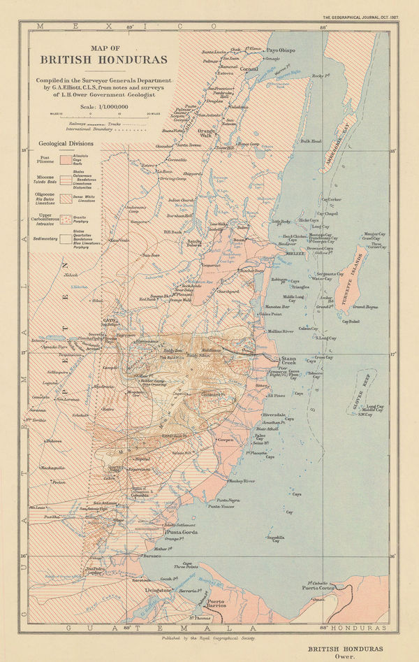
Royal Geographical Society (RGS), Belize (British Honduras), 1927£ 225.00
-
John Bartholomew & Son, Guyana, 1927£ 55.00
-
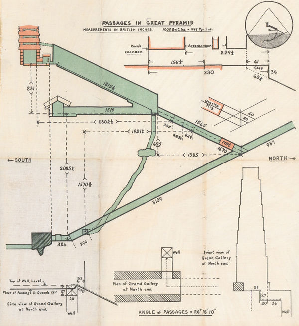
Anonymous, Passages in the Great Pyramid, 1927 c£ 150.00
-
Frederic M. Thrasher, Chicago's Gangland, 1927 c.£ 2,950.00
-
Edward Stanford, Dorsetshire, Somersetshire and South Wiltshire, 1928£ 56.00
-
War Office, Indonesia and New Guinea, 1928£ 875.00
-
Edward Stanford, Hampshire, 1928£ 52.00
-
Edward Stanford, Herefordshire and Monmouthshire, 1928£ 28.00
-
Edward Stanford, Lincolnshire, 1928£ 36.00
-
J. Gordon Hayes, No. 1, Antarctica, 1928£ 795.00
-
J. Gordon Hayes, No. 4 The Ross Dependancy, 1928£ 695.00
-
Edward Stanford, Norfolk, 1928£ 42.00
-
Edward Stanford, Northumberland, 1928£ 28.00
-
Edward Stanford, Suffolk, 1928£ 42.00
-
British Admiralty, The Channel Islands and Adjacent Coasts of France, 1928£ 675.00
-
Arthur B. Suchy, The Heart of Cleveland Ohio, 1928£ 495.00
-
W. & A.K. Johnston, Cook's Map of the World, 1928£ 88.00
-
Karl Baedeker, Amalfi coast, 1928£ 68.00
-
Railway Clearing House, Cardiff, 1928£ 55.00
-
E.G. Perman, Underground Railways of London, 1928£ 1,250.00
-
J.G. Bartholomew, Southwark, Waterloo, Lambeth & Kennington, 1928£ 58.00
-
George W. Bacon, Rotherhithe, Deptford & Bermondsey, 1928£ 55.00
-
George W. Bacon, Bayswater, Notting Hill, Kensal Green & Paddington, 1928£ 78.00
-
Edward Stanford, Cheshire, 1928£ 52.00
-
Ordnance Survey, Isle of Wight, 1928£ 150.00
-
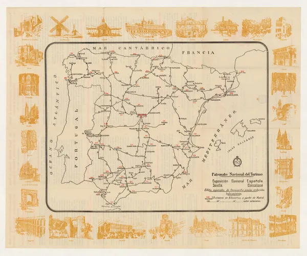
Patronato Nacional del Turismo (P.N.T), Vintage railway map of Spain, 1928 c.£ 125.00
-
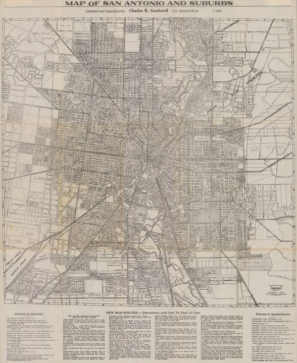
Charles R. Southwell, Map of San Antonio and Suburbs, 1928 c.£ 595.00
-
Edward Stanford, A Map of China and Japan, 1929£ 975.00
-
Rand, McNally & Co., A Pictorial Chart of English Literature, 1929£ 1,450.00
-
Discoveries in Graham Land by Sir Hubert Wilkins, December, 1928, 1929Royal Geographical Society (RGS)Series: LondonRoyal Geographical Society (RGS), Discoveries in Graham Land by Sir Hubert Wilkins, December, 1928, 1929£ 450.00
-
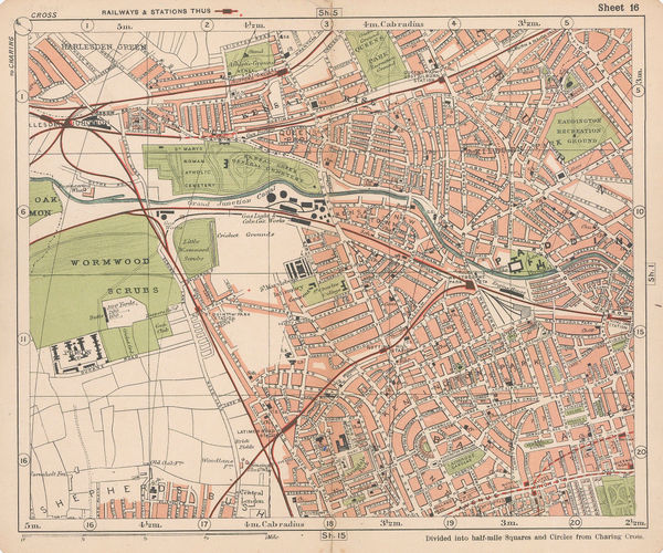
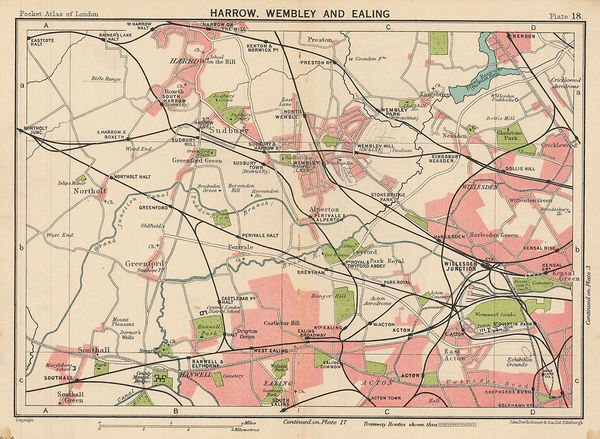
J.G. Bartholomew, Harrow, Wembley and Ealing, 1929£ 42.00
-
Fed. Malay States, Folding map of the Malay Peninsula, 1929£ 675.00
-
Ordnance Survey, Ordnance Survey Road Map of S.W. Cornwall & Scilly Isles, 1929£ 125.00
-
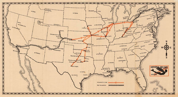
Universal Aviation, Universal Air Lines System, 1929£ 445.00
-
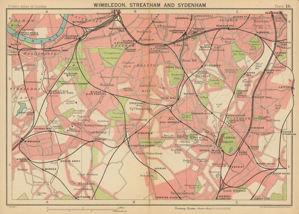
J.G. Bartholomew, Wimbledon, Streatham and Sydenham, 1929£ 44.00
-
A. H. Guillot and L. J. Adam, New Orleans, 1929£ 875.00
-
J.G. Bartholomew, Kew, Richmond and Hampton Court, 1929£ 75.00
-
Chelsea, Fulham, Earl's Court, Battersea, and Hammersmith, 1929John Bartholomew & SonSeries: EdinburghJohn Bartholomew & Son, Chelsea, Fulham, Earl's Court, Battersea, and Hammersmith, 1929£ 125.00
-
Thomas Kelly, Richmond, Teddington, Kew, Chiswick, Twickenham & Isleworth, 1929£ 795.00
-
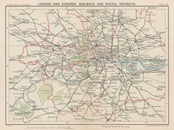
John Bartholomew & Son, London and Suburbs, Railways and Postal Districts, 1929£ 68.00
-
Gerald Allen Eddy, The Ranchos of Los Angeles County, 1929£ 525.00
-
Féret & Fils, Carte Vinicole du Departement de la Gironde, 1929£ 650.00
-
William Harding Thompson, Map of Cornwall, 1929£ 125.00
-
John Bartholomew & Son, Hampstead, Camden, Kentish Town & Holloway, 1929£ 78.00
-
William Harding Thompson, Map of Cornwall, 1929£ 145.00
-
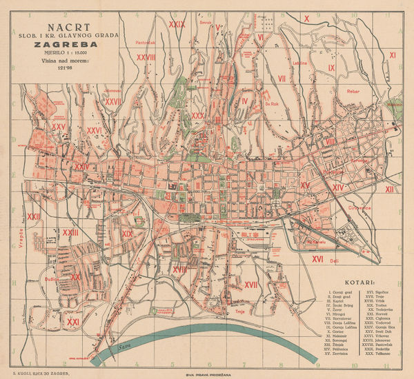
S. Kugli, Zagreb, 1929£ 295.00
-
The City, Wapping, Aldgate, Whitechapel, Liverpool St & Barbican, 1929John Bartholomew & SonSeries: EdinburghJohn Bartholomew & Son, The City, Wapping, Aldgate, Whitechapel, Liverpool St & Barbican, 1929£ 68.00
-
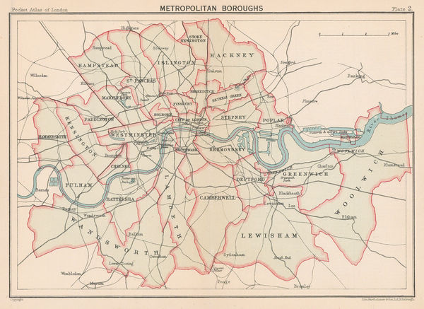
John Bartholomew & Son, Metropolitan Boroughs, 1929£ 65.00
-
John Bartholomew & Son, The Thames to Windsor, 1929£ 55.00
-
Ordnance Survey, Pimlico, 1929 c.£ 1,350.00
-
-
James Daugherty, This World of Ours, 1929 c.£ 2,500.00
-
Anton van der Valk, Humorous pictorial map of Dutch history, 1930£ 295.00
-
Joseph Meyer, Athens, 1930£ 46.00
-
French Admiralty, French chart of Guernsey, Herm and Sark, 1930£ 675.00
-
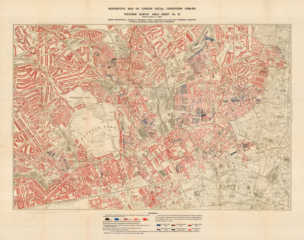
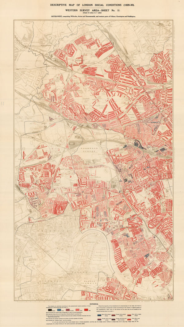
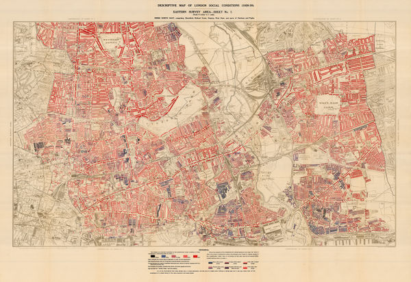
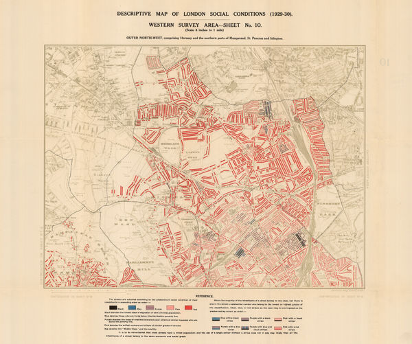
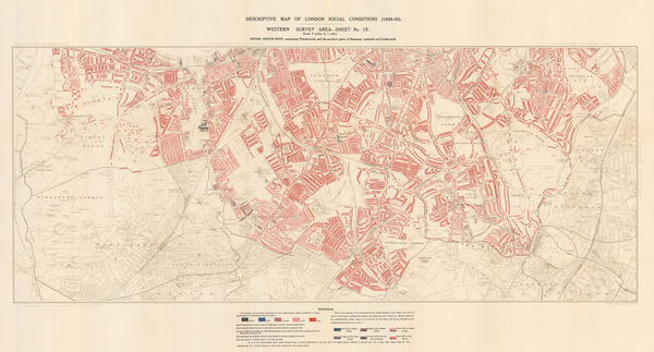
Charles Booth, Descriptive Map of London Social Conditions (1929-1930), 1930£ 1,950.00
-
Charles Booth, Descriptive Map of London Social Conditions (1929-1930), 1930£ 1,550.00
-
Charles Booth, Poverty Map of Whitechapel, Hackney, Shoreditch & Stratford, 1930£ 1,350.00
-
Charles Booth, Descriptive Map of London Social Conditions (1929-1930), 1930£ 950.00
-
Charles Booth, Poverty Map of Wandsworth, Streatham, Tooting, Clapham & Dulwich, 1930£ 1,450.00
-
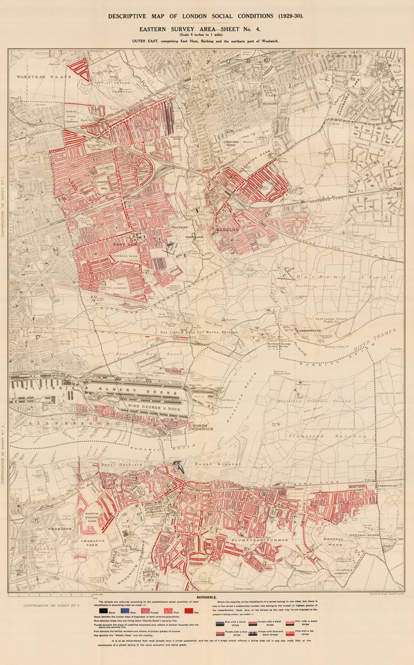
Charles Booth, Poverty Map of Royal Docks, Barking & Woolwich, 1930£ 650.00
-
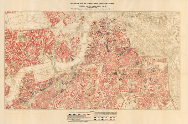
Charles Booth, Descriptive Map of London Social Conditions (1929-1930), 1930£ 2,500.00
-
Royal Geographical Society (RGS), Great Barrier Reef - Low Isles, 1930£ 385.00
-
Service Géographique de l'Armée, Folding vintage map of Morocco, 1930£ 375.00
-
National Map Company, National Street Map of the Pittsburgh Area, 1930£ 1,750.00
-
Joseph Meyer, City plan of Naples, 1930£ 68.00
-
Service Géographique de l'Armée, Vintage map of Marrakesh, 1930£ 475.00
-
Joseph Meyer, Antwerp, 1930£ 28.00
-
Vicente de Castro Les, Madrid, 1930£ 175.00
-
Survey of India, Road Map of India (excluding Burma), 1930£ 495.00
-
British Admiralty, The Brothers to Ockseu Is., 1930£ 1,750.00
-
Royal Geographical Society (RGS), Three Isles (Great Barrier Reef), 1930£ 385.00
-
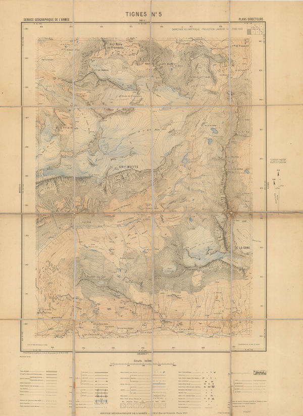
Service géographique de l'armée, Tignes/Glaciers de la Motte, 1930£ 450.00


Page
116
of 131