-
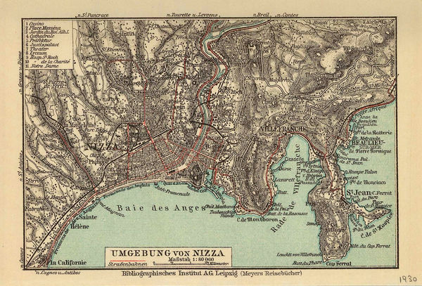
 Joseph Meyer, Nice and environs, 1930£ 28.00
 -
Jean Dollfus, Rhone Valley, 1930£ 950.00
-
Frederick William Simpson, Electric Tramway map of Perth, 1930£ 950.00
-
R Bakalla, Plan of Innsbruck, 1930£ 195.00
-
Royal Geographical Society (RGS), Petra, 1930£ 275.00
-
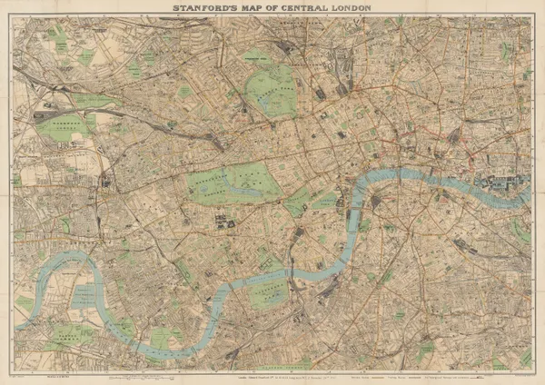
Edward Stanford, Stanford's Map of Central London, 1930£ 850.00
-
-
Tymoteusz Sawicki, Warsaw, 1930£ 495.00
-
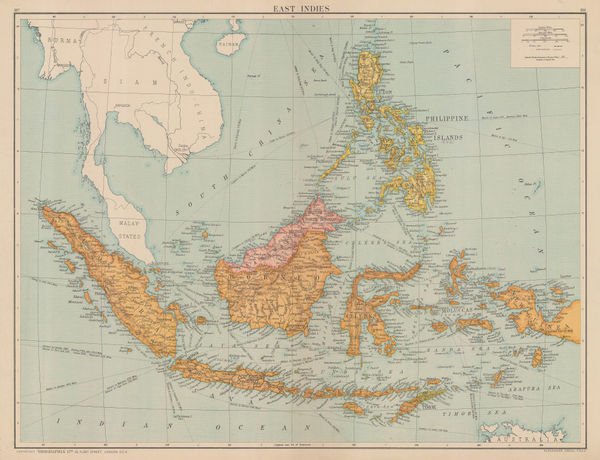
Geographia Ltd., Indonesia, Borneo, Brunei, and the Philippines, 1930 (c.)£ 195.00
-
Edward Stanford, P&O Ports of Call - Colombo, 1930 (c.)£ 85.00
-
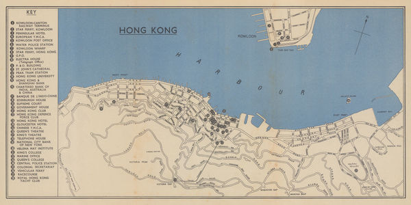
Edward Stanford, P&O Ports of Call - Hong Kong, 1930 (c.)£ 445.00
-
Ward, Lock & Co, The Cotswolds - North, 1930 (c.)£ 175.00
-
Ward, Lock & Co, The Cotswolds - South, 1930 (c.)£ 145.00
-
Freytag & Berndt, The Yugoslavian Riviera (Croatia & Bosnia), 1930 (c.)£ 400.00
-
John Bartholomew & Son, Adelaide - P&O Ports Guide, 1930 (c.)£ 75.00
-
Iliffe & Sons Ltd., The Autocar Folding Map of Scotland, 1930 (c.)£ 450.00
-
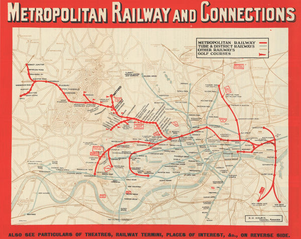
London Underground, Metropolitan Railway and Connections, 1930 (c.)£ 550.00
-
Anonymous, Environs of Marrakesh, 1930 c£ 68.00
-
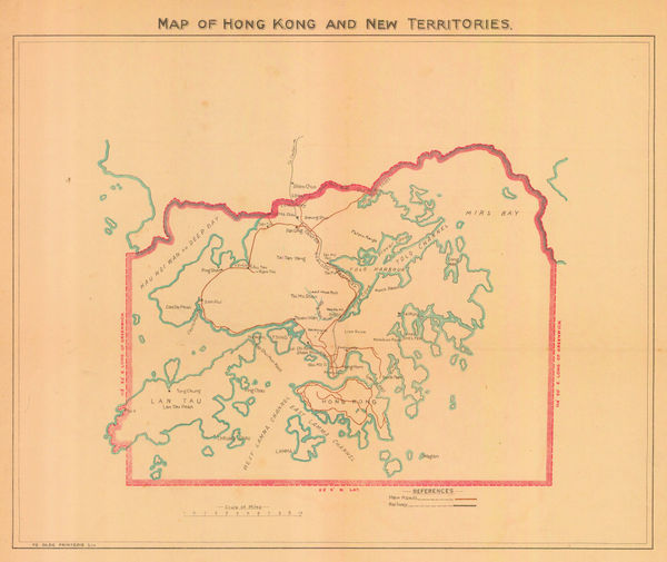
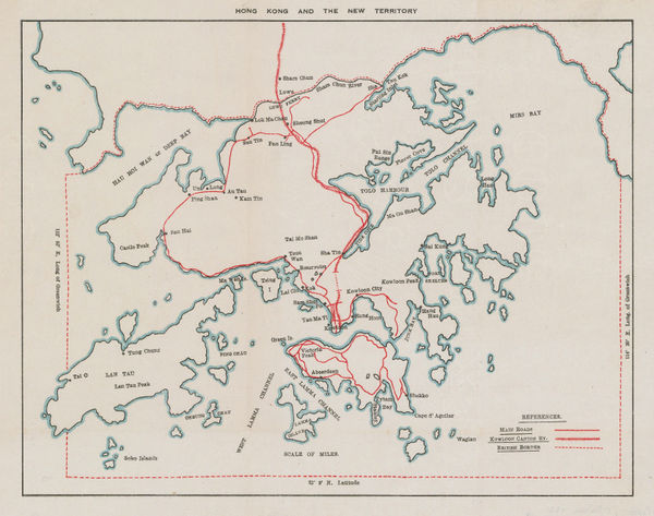
Ye Olde Printerie, Map of Hong Kong and New Territories, 1930 c£ 1,350.00
-
California State Automobile Association, North Bay Counties, 1930 c£ 395.00
-
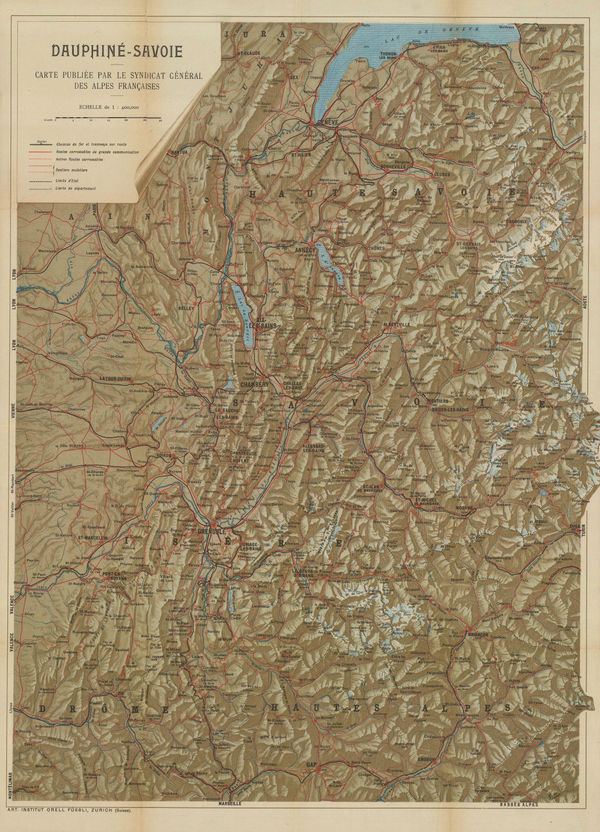
Orell Füssli, Dauphine-Savoie, 1930 c£ 650.00
-
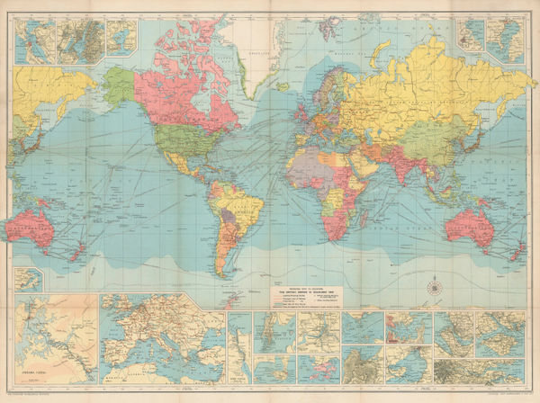
J.G. Bartholomew, Route Chart of the World, 1930 c£ 750.00
-
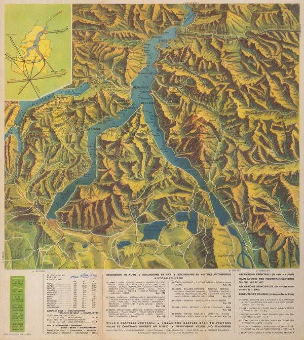
Barabino & Graeve, Lake Como, 1930 c£ 395.00
-
J.G. Bartholomew, Edinburgh, 1930 c£ 450.00
-
Rand, McNally & Co., A New Street Number Guide Map of Chicago and Suburbs, 1930 c.£ 525.00
-
John Murray, Varanasi (Benares), 1930 c.£ 48.00
-
Jean Dollfus, Burgundy Nievres, 1930 c.£ 950.00
-
Carta delle Zone Faunistiche della Provincia di Brindisi, 1930 c.Ministero dell'agricoltura e delle foresteSeries: NovaraMinistero dell'agricoltura e delle foreste, Carta delle Zone Faunistiche della Provincia di Brindisi, 1930 c.£ 450.00
-
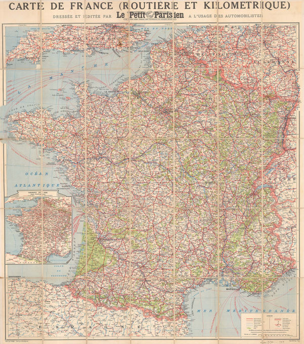
R. Bolze, Vintage road map of France, 1930 c.£ 175.00
-
Clason Map Co., Clason's Guide Map of California and Nevada, 1930 c.£ 645.00
-
Alexander Gross, Thailand, Malaysia, Laos, Cambodia and Vietnam, 1930 c.£ 625.00
-
-
George Philip & Son Ltd., Italy Jigsaw Puzzle, 1930 c.£ 385.00
-
Hadlow & Sons, Brighton & Hove, 1930 c.£ 225.00
-
H. Wise & Co., Map of City and Suburbs of Dunedin, 1930 c.£ 695.00
-
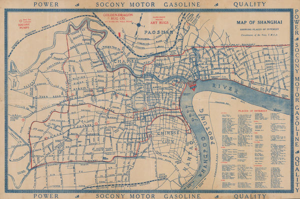
Navy Y. M. C. A., Map of Shanghai, 1930 c.£ 895.00
-
Cartes Tarides, Morocco based on French army surveys, 1930 c.£ 595.00
-
John Kirk Sewall, Pictorial map of Beijing, 1930 c.£ 3,500.00
-
George Philip & Son Ltd., Philips' New Wall Map of East Africa, 1930 c.£ 1,250.00
-
Intourist, Pictorial Map of the Caucasus, 1930 c.£ 1,750.00
-
Editions France Afrique, Vintage folding plan of Marrakesh, 1930 c.£ 845.00
-
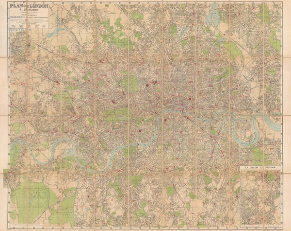
Geographia Ltd., Plan of London & Suburbs, 1930 c.£ 495.00
-
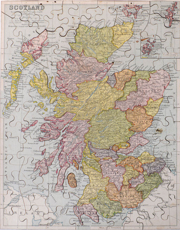
George Philip & Son Ltd., Scotland Jigsaw Puzzle, 1930 c.£ 325.00
-
Ward, Lock & Co, The Cotswolds, 1930 c.£ 55.00
-
J.W. Harding & Co., Touring Map of the Cornish Riviera, 1930 c.£ 375.00
-
Alexander Nicohosoff, Tourist Map of Cairo, 1930 c.£ 145.00
-
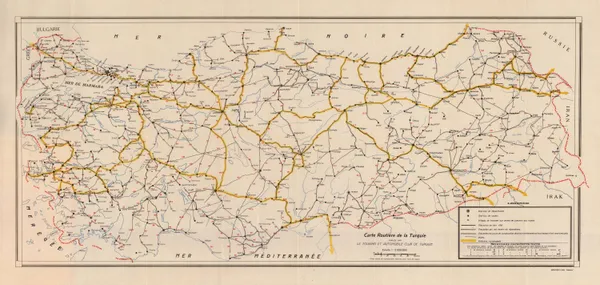
Basimevi Emel, Road map of Turkey, 1930 c.£ 125.00
-
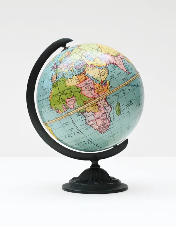
Volksverbandes der Bücherfreunde, 12 Inch German Terrestrial Globe, 1930 c.£ 1,650.00
-
Orell Füssli, Zurich, 1930 c.£ 325.00
-
Harmsworth, Gallipoli and Suvla Bay, 1930 c.£ 65.00
-
-
Geographers' Map Co., London, 1930 c.£ 145.00
-
McCorquodale & Co., Gilbey's Rubicon Burgundy, 1930 c.£ 200.00
-
Weber Costello, Peerless 6-Inch Terrestrial Globe, 1930 c.£ 450.00
-
George Philip & Son Ltd., Philip’s 12-inch Terrestrial Globe , 1930 c.£ 1,950.00
-
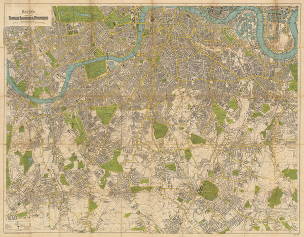
George W. Bacon, South London & Suburbs, 1930 c.£ 650.00
-
Kroll Map Co., Guide Map to Seattle, 1930 c.£ 725.00
-
Boulder Chamber of Commerce, City Map - Boulder, Colorado, 1930 c.£ 125.00
-
Royal Geographical Society (RGS), Arabia - Sketch map of Hadhramaut, 1931£ 145.00
-
Royal Geographical Society (RGS), Central South Arabia, 1931£ 375.00
-
Turzak & Chapman, Chicago USA, 1931£ 2,500.00
-
Sifton Praed & Co., Suriname, 1931£ 24.00
-
-
Nathan Mayo, Historical Map of Florida, 1931£ 285.00
-
Survey of India, Lahore and environs, 1931£ 585.00
-
-
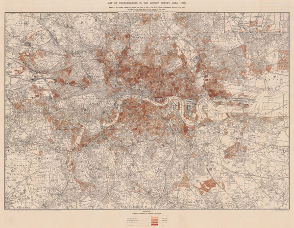
Charles Booth, Map of Overcrowding in the London Survey Area (1931), 1931£ 1,950.00
-
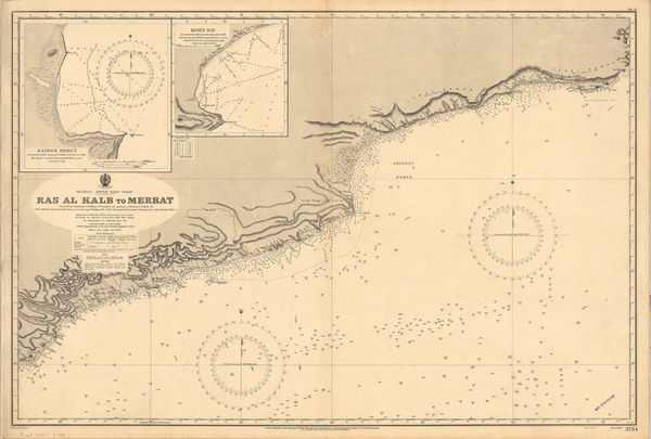
British Admiralty, Merbat to Masira Island., 1931£ 1,550.00
-
British Admiralty, Chart of the South Arabian coast, 1931£ 1,550.00
-
Recent Work of Norwegian Expeditions in the Antarctic Regions, 1931Royal Geographical Society (RGS)Series: LondonRoyal Geographical Society (RGS), Recent Work of Norwegian Expeditions in the Antarctic Regions, 1931£ 375.00
-
The Libyan Desert showing the Routes of Major R. A. Bagnold's Expeditions 1929 & 1930, 1931Royal Geographical Society (RGS)Series: LondonRoyal Geographical Society (RGS), The Libyan Desert showing the Routes of Major R. A. Bagnold's Expeditions 1929 & 1930, 1931£ 285.00
-
Paplow & Barber, Hong Kong, 1931£ 875.00
-
Swedish Traffic Association, Sweden, 1931£ 750.00
-
Royal Geographical Society (RGS), Rub' al Khali from Dhufar to Doha, 1931£ 1,350.00
-
Fred H. Stingemore, Map of London's Underground Railways, 1931£ 795.00
-
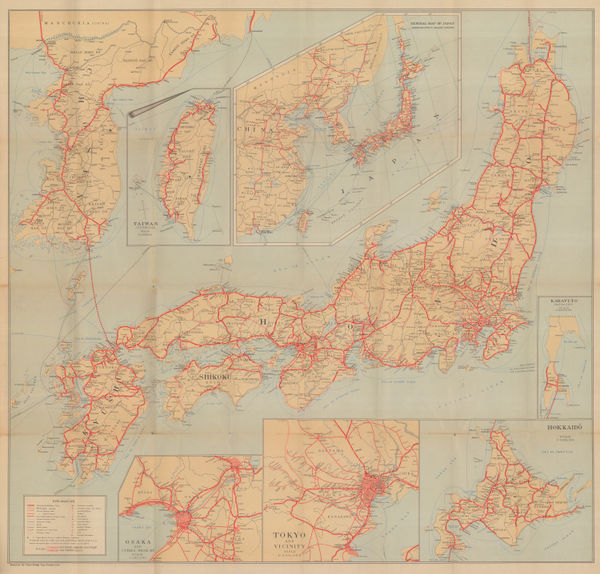
Japanese Railways, General Map of Japan, 1931£ 875.00
-
Anonymous, Plan of Palma, Mallorca , 1931£ 645.00
-
Justus Perthes, Western Iran, Iraq & the Caucasus, 1931£ 145.00
-
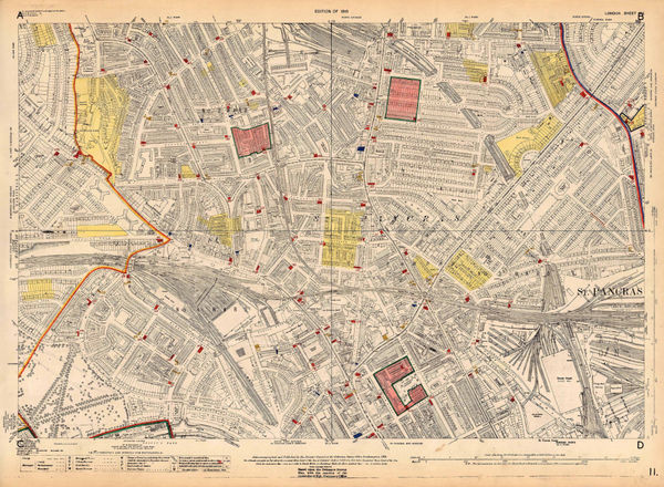
Ordnance Survey, Primrose Hill and St. Pancras, 1931 c.£ 825.00
-
Royal Geographical Society (RGS), Antarctic Regions, 1932£ 1,400.00


Page
117
of 131