-
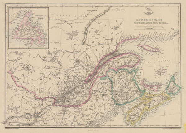
 Henry Teesdale, Canada, New Brunswick and Nova Scotia, 1845£ 185.00
 -
George Frederick Cruchley, North America, 1845£ 120.00
-
Royal Geographical Society (RGS), The Grijalva River, 1845£ 85.00
-
Samuel Augustus Mitchell, Southern Ontario and the Great Lakes, 1846£ 325.00
-
Samuel Augustus Mitchell, North America, 1846 c£ 175.00
-
Victor Levasseur, Decorative map of North and Central America, 1847£ 495.00
-
North America divided into drainage basins of its great rivers, 1847Joseph MeyerSeries: HildburghausenJoseph Meyer, North America divided into drainage basins of its great rivers, 1847£ 245.00
-
W. & A.K. Johnston, Mountain Chains in North America, 1848£ 175.00
-
Joseph Meyer, Bergsystem von Nord-America, 1848£ 295.00
-
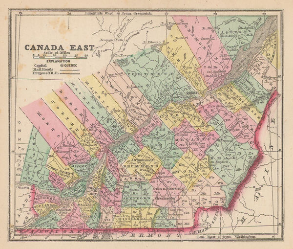
Samuel Augustus Mitchell, Quebec Province, 1850£ 90.00
-
James Wyld, Central America, 1850£ 695.00
-
John Dower, North America, 1850 c.£ 115.00
-
Peter Jackson, Eastern Canada, 1850 c.£ 68.00
-
Sidney Hall, North America, 1850 c.£ 325.00
-
John Tallis, Canada, New Brunswick, 1851£ 235.00
-
John Tallis, Panama & Costa Rica, 1851£ 325.00
-
John Tallis, North America, 1851£ 595.00
-
John Tallis, Southern Ontario, 1851£ 375.00
-
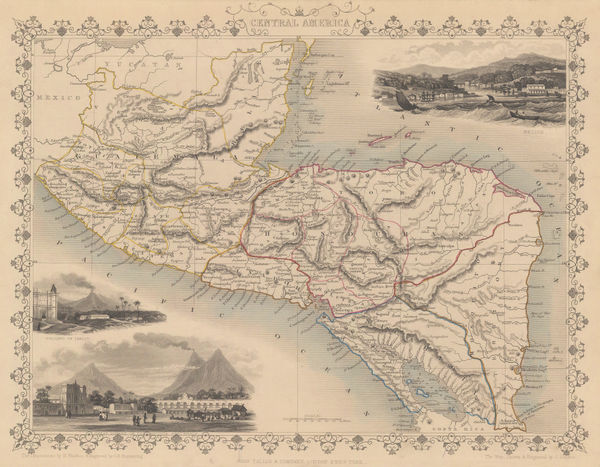
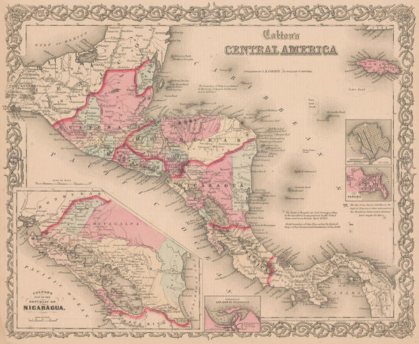
John Tallis, Central America, 1851£ 385.00
-
Royal Geographical Society (RGS), Proposal for a Nicaragua Canal, 1851£ 175.00
-
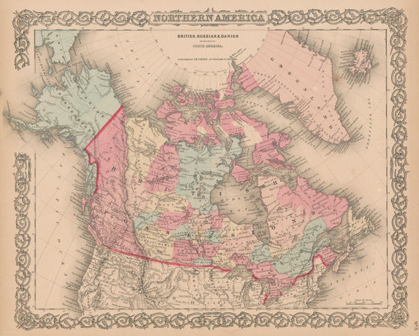
John Arrowsmith, British North America, 1852£ 895.00
-
Aimé Robiquet, Chart of Central America, 1852£ 725.00
-
Royal Geographical Society (RGS), Route map of Canada, 1852£ 325.00
-
James Wyld, Map of North America, 1852 c.£ 300.00
-
George Matthews, Railway map of Quebec and Ontario, 1853£ 195.00
-
North America after the conclusion of the Mexican-American War , 1853Joseph MeyerSeries: HildburghausenJoseph Meyer, North America after the conclusion of the Mexican-American War , 1853£ 195.00
-
Royal Geographical Society (RGS), Southern part of the Isthmus of Panama, 1853£ 140.00
-
Yucatan, Belize, Guatemala, Salvador, Honduras, Nicaragua and the southern states of Mexico, 1853Society for the Diffusion of Useful Knowledge (SDUK)Series: LondonSociety for the Diffusion of Useful Knowledge (SDUK), Yucatan, Belize, Guatemala, Salvador, Honduras, Nicaragua and the southern states of Mexico, 1853£ 195.00
-
British Admiralty, Chart of the coast of Costa Rica, 1854£ 200.00
-
Joseph Hutchins Colton, Canada East or Lower Canada and New Brunswick, 1855£ 95.00
-
Joseph Meyer, Canada, Alaska and Greenland, 1855 c.£ 165.00
-
George Philip, Canada, Nova Scotia & New Brunswick &c., 1856£ 220.00
-
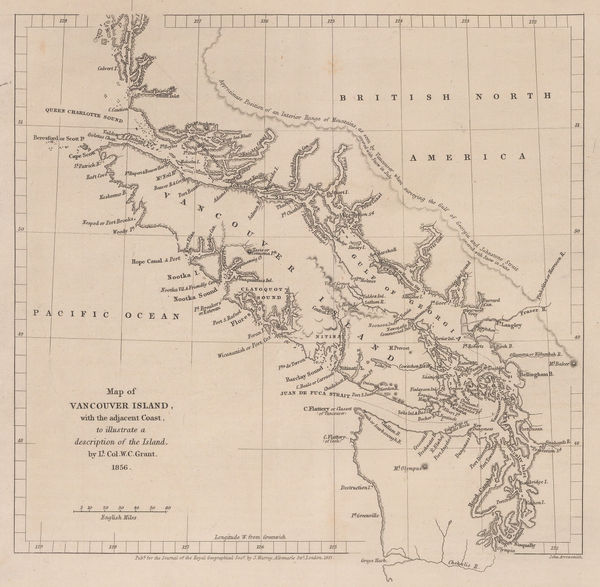
Royal Geographical Society (RGS), Southern coast of Vancouver Island, 1856£ 195.00
-
Morse & Gaston, Quebec Province, 1857£ 32.00
-
Royal Geographical Society (RGS), Isthmus of Panama, 1857£ 225.00
-
Royal Geographical Society (RGS), Vancouver Island and coast of British Columbia, 1857£ 485.00
-
Map to illustrate a journey to the North Western Provinces of Mexico by Ch. Sevin., 1859Royal Geographical Society (RGS)Series: LondonRoyal Geographical Society (RGS), Map to illustrate a journey to the North Western Provinces of Mexico by Ch. Sevin., 1859£ 215.00
-
F.A. Brockhaus, Decorative map of North America, 1859£ 675.00
-
Honduras & El Salvador showing the proposed railway from Puerto Cortés to Amapala, 1859Royal Geographical Society (RGS)Series: LondonRoyal Geographical Society (RGS), Honduras & El Salvador showing the proposed railway from Puerto Cortés to Amapala, 1859£ 125.00
-
Auguste-Henri Dufour, North America, 1860 c.£ 325.00
-
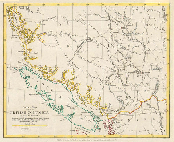
Archibald Fullarton, British Columbia & Vancouver Island, 1860 c.£ 545.00
-
East Canada and New Brunswick, 1860 c.Society for the Diffusion of Useful Knowledge (SDUK)Series: LondonSociety for the Diffusion of Useful Knowledge (SDUK), East Canada and New Brunswick, 1860 c.£ 95.00
-
Newfoundland, New Brunswick, Nova Scotia, Prince Edward Island, 1860 c.Archibald FullartonSeries: LondonArchibald Fullarton, Newfoundland, New Brunswick, Nova Scotia, Prince Edward Island, 1860 c.£ 85.00
-
John Rapkin, North America, 1860 c.£ 135.00
-
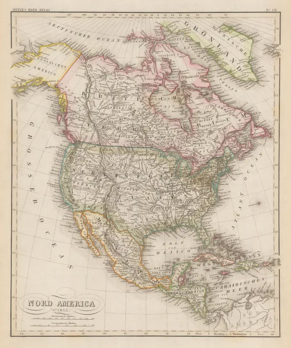
Archibald Fullarton, North America, 1860 c.£ 195.00
-
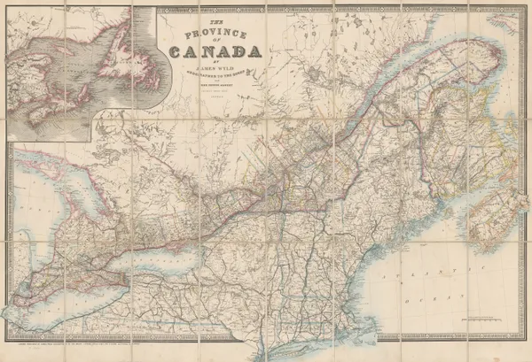
James Wyld, The Province of Canada, 1860 c.£ 1,450.00
-
Royal Geographical Society (RGS), Southern British Columbia and Vancouver Island, 1861£ 445.00
-
Justus Perthes, The Coast of Labrador, 1861£ 88.00
-
Joseph Hutchins Colton, Canada, Alaska & Greenland, 1861£ 195.00
-
Joseph Hutchins Colton, Central America, 1861£ 195.00
-
Joseph Hutchins Colton, North America, 1861£ 175.00
-
James Cowles Prichard, Ethnographic Map of North America, 1861£ 550.00
-
Justus Perthes, Isthmus of Panama, 1862£ 66.00
-
Royal Geographical Society (RGS), Mosquito (Miskito) Coast, Honduras & Nicaragua, 1862£ 185.00
-
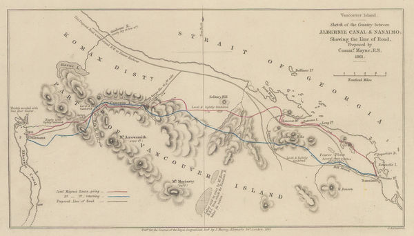
Southern Vancouver Island from Alberni Inlet to Nanaimo, 1862Royal Geographical Society (RGS)Series: LondonRoyal Geographical Society (RGS), Southern Vancouver Island from Alberni Inlet to Nanaimo, 1862£ 60.00
-
Joseph Hutchins Colton, Canada West, 1862£ 195.00
-
Johnson's New Brunswick, Nova Scotia, Newfoundland, and Prince Edward Id., 1863Johnson & WardSeries: New YorkJohnson & Ward, Johnson's New Brunswick, Nova Scotia, Newfoundland, and Prince Edward Id., 1863£ 65.00
-
Edward Weller, Lower Canada, New Brunswick, Nova Scotia, 1863£ 45.00
-
Society for the Diffusion of Useful Knowledge (SDUK), North America, 1863£ 125.00
-
Edward Weller, North America, 1863£ 175.00
-
Justus Perthes, Chiriquí Province, 1863£ 95.00
-
Johnson & Ward, Ontario and Quebec, 1863 c.£ 150.00
-
Royal Geographical Society (RGS), Map of Newfoundland, 1864£ 145.00
-
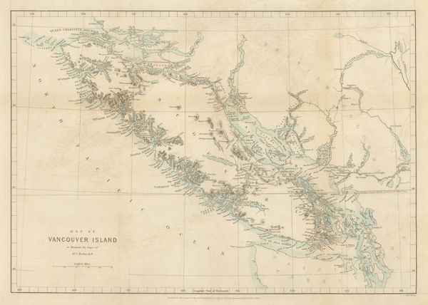
Royal Geographical Society (RGS), Vancouver Island, 1864£ 525.00
-
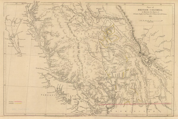
Royal Geographical Society (RGS), Vancouver Island & British Columbia, 1864£ 375.00
-
Royal Geographical Society (RGS), Isthmus of Panama, 1865£ 75.00
-
Map of the Province of Nova Scotia including the Island of Cape Breton, 1865 c.A. & W. McKinlaySeries: Halifax, N.S.A. & W. McKinlay, Map of the Province of Nova Scotia including the Island of Cape Breton, 1865 c.£ 495.00
-
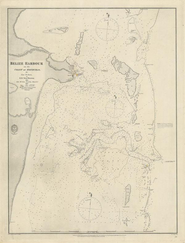
British Admiralty, Coast and Harbour of Belize City, 1866£ 785.00
-
Royal Geographical Society (RGS), Isthmus of Panama & Gulf of Urabá, 1867£ 195.00
-
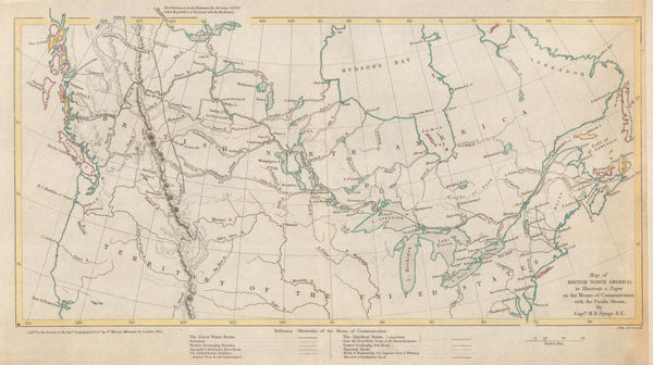
Sketch Map Showing Proposed Communication Between Canada & British Columbia, 1868Royal Geographical Society (RGS)Series: LondonRoyal Geographical Society (RGS), Sketch Map Showing Proposed Communication Between Canada & British Columbia, 1868£ 58.00
-
Justus Perthes, Vancouver Island, 1869£ 425.00
-
Justus Perthes, Arctic Russia, Wrangel Island & the Bering Strait, 1869£ 125.00
-
John Dower, Canada &c., 1870 c.£ 78.00
-
Archibald Fullarton, Canada with part of the United States, 1870 c.£ 125.00
-
Justus Perthes, North America, 1870 c.£ 80.00
-
Archibald Fullarton, Quebec City and environs, 1870 c.£ 45.00
-
Justus Perthes, North America showing missions and reservations, 1871£ 55.00
-
James Wyld, North America, 1874£ 125.00
-
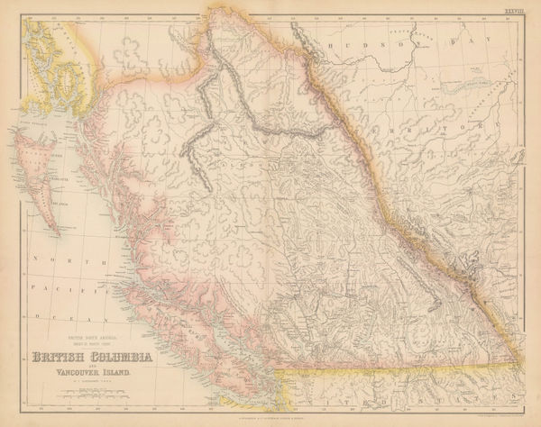
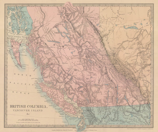
Society for the Diffusion of Useful Knowledge (SDUK), British Columbia & Vancouver Island, 1875£ 385.00
-
Southern Ontario with parts of New York, Pennsylvania, and Michigan, 1875Society for the Diffusion of Useful Knowledge (SDUK)Series: LondonSociety for the Diffusion of Useful Knowledge (SDUK), Southern Ontario with parts of New York, Pennsylvania, and Michigan, 1875£ 245.00


Page
4
of 6