-
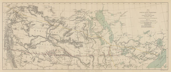
 Western Canada showing Canada-United States border, 1876Royal Geographical Society (RGS)Series: LondonRoyal Geographical Society (RGS), Western Canada showing Canada-United States border, 1876£ 375.00
 -
Adrien Brue, Carte de L'Amerique Septentrionale, 1876£ 175.00
-
Lucien Wyse, Southern part of the Isthmus of Panama, 1877£ 595.00
-
Heinrich C. Kiepert, North America with political borders, 1877£ 145.00
-
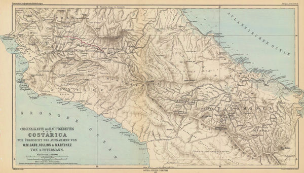
Justus Perthes, Costa Rica, 1877£ 325.00
-
William Collins, Dominion of Canada, 1877 c£ 95.00
-
Edward Stanford, Geological Map of Newfoundland, 1879£ 3,250.00
-
Justus Perthes, Yucatan, 1879£ 295.00
-
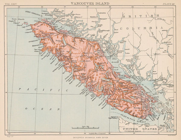
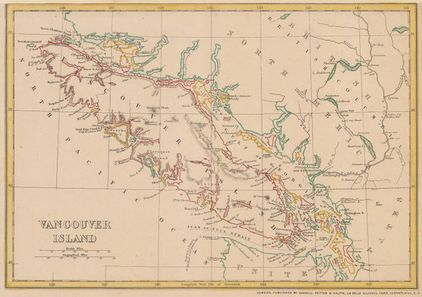
W. & A.K. Johnston, Vancouver Island, 1880 (c.)£ 95.00
-
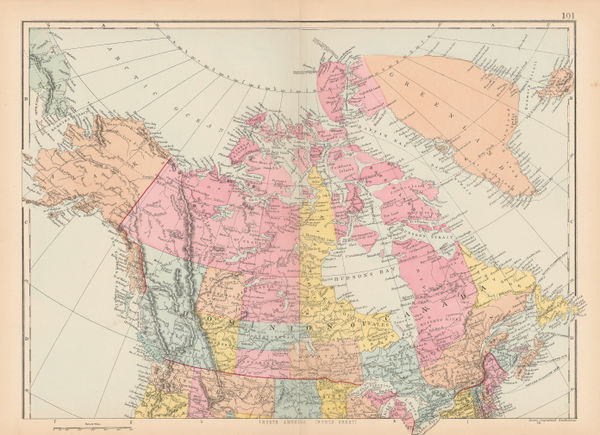
Society for the Diffusion of Useful Knowledge (SDUK), Dominion of Canada, 1880 c.£ 345.00
-
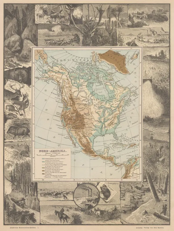
Otto Spamer, North America showing elevations, 1880 c.£ 145.00
-
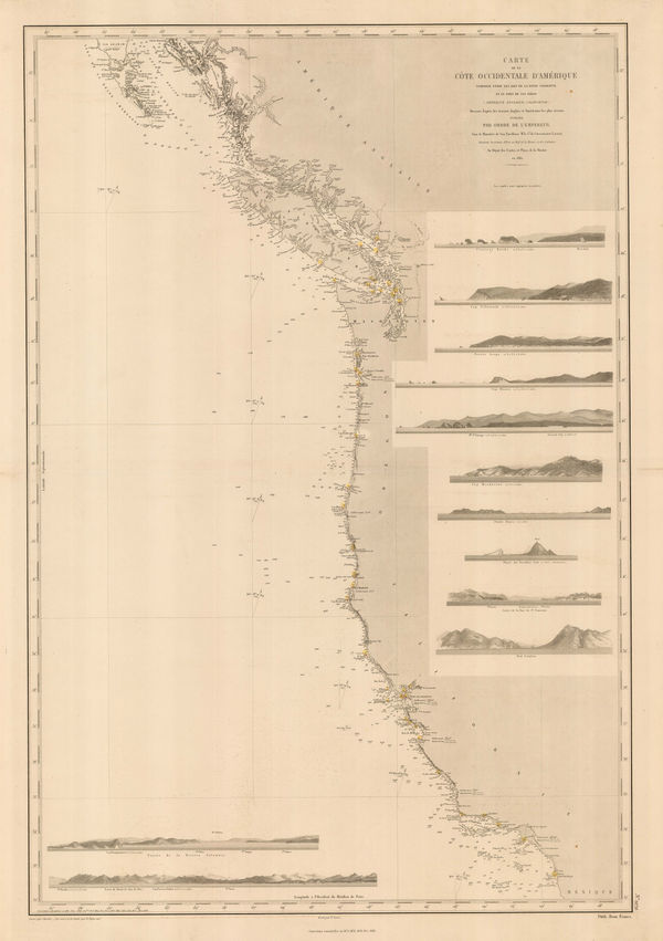
French Admiralty, Chart of the west coast of North America, 1881£ 825.00
-
Map of Hudson Bay and part of the Dominion of Canada, 1881Royal Geographical Society (RGS)Series: LondonRoyal Geographical Society (RGS), Map of Hudson Bay and part of the Dominion of Canada, 1881£ 145.00
-
A. Simon, Montreal, 1881£ 325.00
-
Justus Perthes, Geological Map of Haida Gwaii, British Columbia, 1881£ 125.00
-
Royal Geographical Society (RGS), Athabasca District, Saskatchewan, 1883£ 395.00
-
Letts & Son, Southern Québec and New Brunswick, 1883£ 48.00
-
Justus Perthes, Sinaloa - Mexico, 1884£ 295.00
-
Justus Perthes, North and Central America and West Indies, 1885£ 145.00
-
Thomas A. Janvier, Mexico City, 1885£ 595.00
-
Henry Cuthbert Tunison, Ontario & Quebec, 1885£ 275.00
-
George W. Bacon, Ontario and the Great Lakes, 1885 (c.)£ 345.00
-
George W. Bacon, Canada, 1885 (c.)£ 225.00
-
John Cassell, Vancouver Island, 1885 c.£ 195.00
-
J.G. Bartholomew, North America, 1886£ 42.00
-
Royal Geographical Society (RGS), Ruins at Copan, 1886£ 345.00
-
J.G. Bartholomew, Dominion of Canada, 1887£ 56.00
-
A. Simon, Quebec City, 1888£ 175.00
-
Letts & Son, Lake Superior, 1889£ 92.00
-
George Cram, Eastern Part of Ontario, 1889£ 52.00
-
George Cram, Southern Nova Scotia, 1889£ 42.00
-
George Cram, Central Nova Scotia, 1889£ 42.00
-
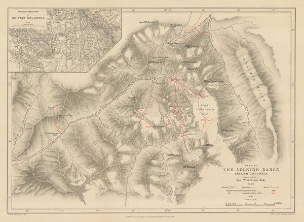
Royal Geographical Society (RGS), Selkirk Range, British Columbia, 1889£ 115.00
-
George Cram, South-Western Part of Ontario, 1889£ 52.00
-
Arbuckle Brothers Company, Dominion of Canada, 1889£ 115.00
-
Arbuckle Brothers Company, Newfoundland, 1889£ 95.00
-
Arbuckle Brothers Company, Mexico, 1889£ 145.00
-
Royal Geographical Society (RGS), Yahtse-Tah-Shah or Mt. St. Elias, 1889£ 125.00
-
Thomas A. Janvier, The Environs of Mexico City, 1889£ 95.00
-
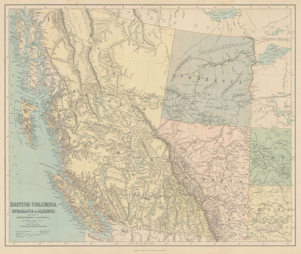
George Philip & Son Ltd., British Columbia, Athabasca & Alberta, 1890£ 245.00
-
J.G. Bartholomew, Newfoundland, 1890 c.£ 36.00
-
Royal Geographical Society (RGS), Map of Newfoundland, 1890 c.£ 245.00
-
F Bianconi, Economic Map of Guatemala, 1890 c.£ 1,950.00
-
British Admiralty, Gulf of Mexico, 1891£ 1,550.00
-
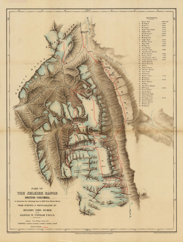
Royal Geographical Society (RGS), Selkirk Range, British Columbia, 1891£ 145.00
-
Sketch map of North America Showing Approximately The Extent and Value of Its Geographical Surveys, 1891Scottish Geographical Society (SGS)Series: EdinburghScottish Geographical Society (SGS), Sketch map of North America Showing Approximately The Extent and Value of Its Geographical Surveys, 1891£ 175.00
-
Rare linguistic map of the indigenous peoples of North America, 1891 c.John Wesley PowellSeries: New YorkJohn Wesley Powell, Rare linguistic map of the indigenous peoples of North America, 1891 c.£ 495.00
-
Letts & Son, Letts's Map of North America, 1892£ 46.00
-
Route of an expedition to the Buena Vista Mountains and Cerro Chirripo, Costa Rica, 1892Justus PerthesSeries: GothaJustus Perthes, Route of an expedition to the Buena Vista Mountains and Cerro Chirripo, Costa Rica, 1892£ 225.00
-
William Bradley & Bro., Mexico, 1894£ 165.00
-
Scottish Geographical Society (SGS), Map of the Labrador Peninsula, 1895£ 325.00
-
D. Appleton & Company, Montreal, 1895£ 75.00
-
Royal Geographical Society (RGS), The Valley of Mexico, 1896£ 145.00
-
Edward Stanford, Ontario, Quebec, New Brunswick & Nova Scotia, 1896£ 95.00
-
Edward Stanford, Canada, 1896£ 85.00
-
Ulrico Hoepli, Miniature map of North America, 1897£ 44.00
-
Royal Geographical Society (RGS), Costa Rica, 1897£ 395.00
-
W. & A.K. Johnston, Folding wall map of North America, 1897£ 1,950.00
-
George Cram, Ontario, 1897£ 225.00
-
Royal Geographical Society (RGS), Nottaway River, Quebec, 1897£ 295.00
-
Edward Stanford, Western Canada, 1898£ 195.00
-
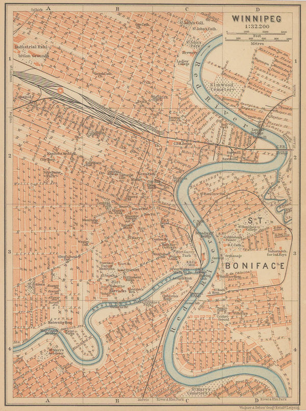
Karl Baedeker, Winnipeg, 1898£ 42.00
-
Royal Geographical Society (RGS), North East Nicaragua, 1898£ 295.00
-
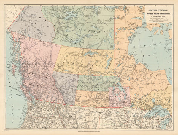
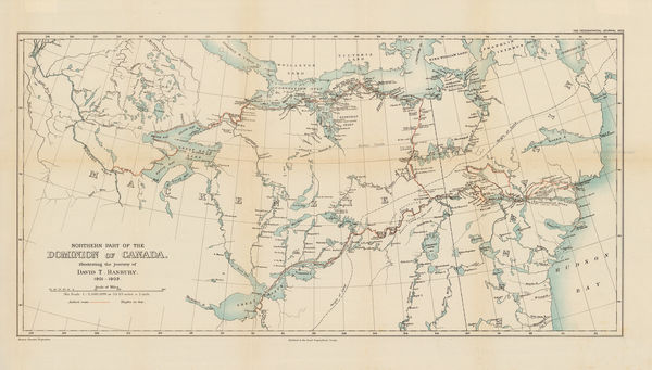
The North-Western Part of the Dominion of Canada, 1898Royal Geographical Society (RGS)Series: LondonRoyal Geographical Society (RGS), The North-Western Part of the Dominion of Canada, 1898£ 495.00
-
Royal Geographical Society (RGS), Waputik Mountains, Canadian Rockies, 1899£ 165.00
-
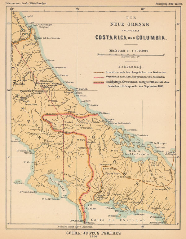
Justus Perthes, Settling the Costa Rica-Colombia Border Dispute, 1900£ 145.00
-
Karl Baedeker, Central and southern Mexico, 1900 c.£ 38.00
-
Karl Baedeker, Canada, 1900 c.£ 58.00
-
Royal Geographical Society (RGS), Great Bear Lake and environs, 1901£ 95.00
-
Royal Geographical Society (RGS), Mexico, 1903£ 110.00
-
Royal Geographical Society (RGS), Northeastern Canada, 1903£ 295.00
-
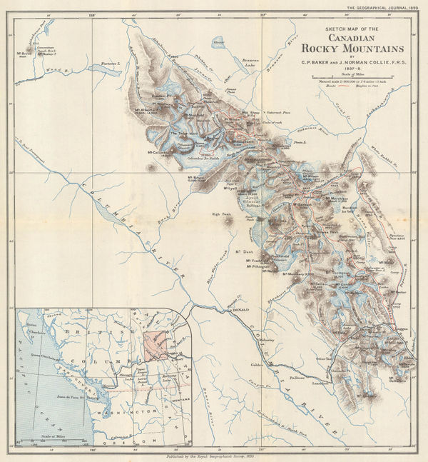
Part of the Canadian Rocky Mountains, British Columbia, 1903Royal Geographical Society (RGS)Series: LondonRoyal Geographical Society (RGS), Part of the Canadian Rocky Mountains, British Columbia, 1903£ 275.00
-
Captain Sverdrup's Arctic Expedition in the 'Fram.' 1899-1902, 1903Scottish Geographical Society (SGS)Series: EdinburghScottish Geographical Society (SGS), Captain Sverdrup's Arctic Expedition in the 'Fram.' 1899-1902, 1903£ 325.00
-
C. J. Pilkey, Plan of the City of Toronto, 1903£ 625.00
-
Edward Stanford, Newfoundland, 1904£ 295.00
-
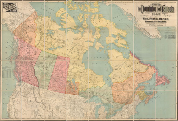
Frank Oliver, Map of the Dominion of Canada, 1905£ 3,950.00
-
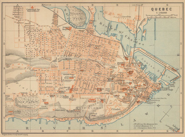
Karl Baedeker, Quebec City, 1905 c.£ 48.00
-
Canadian Government, Map of natural resource of Canada, 1906£ 445.00
-
James White, Ethnographic map of Ontario and Quebec, 1906£ 225.00
-
Julius Bien, Panama Canal, 1906£ 1,450.00


Page
5
of 6