-
 Drainage Map of the Island of Hawaii, 1913United States Geological Survey (USGS)Series: Washington, D.C.United States Geological Survey (USGS), Drainage Map of the Island of Hawaii, 1913£ 375.00
 -
Edward Stanford, Railway Map of the US & Canada, 1913£ 1,450.00
-
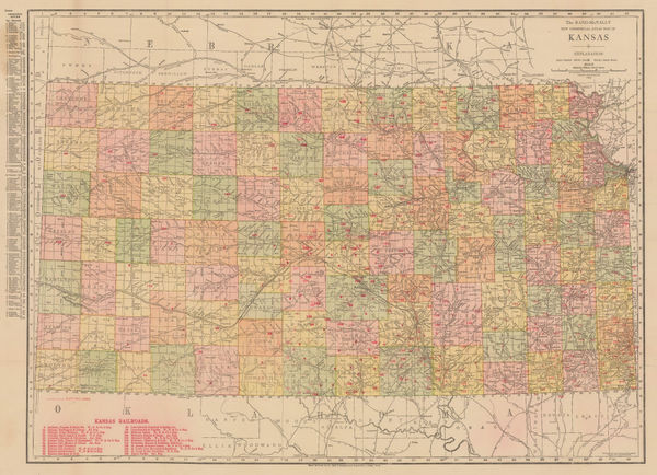
Rand, McNally & Co., New Commercial Atlas Map of Kansas, 1914£ 295.00
-
Rand, McNally & Co., New Commercial Atlas Map of Nevada, 1914£ 395.00
-
Clason Map Co., Clason's Guide Map of Washington, 1914 c.£ 195.00
-
Indian Reservations in the United States, 1915, 1915United States Geological Survey (USGS)Series: Washington, D.C.United States Geological Survey (USGS), Indian Reservations in the United States, 1915, 1915£ 525.00
-
C.N. Caspar & Co., Caspar's Official Map of the City of Milwaukee and Vicinity, 1916£ 595.00
-
James Perrin Smith, Geological Map of California, 1916£ 4,000.00
-
G. Delattre & Cie., First World War French propaganda poster, 1917 c.£ 825.00
-
Brady Standard Print, McCulloch County Texas, 1918£ 885.00
-
Indian Reservations West of the Mississippi River, 1919United States Geological Survey (USGS)Series: Washington, D.C.United States Geological Survey (USGS), Indian Reservations West of the Mississippi River, 1919£ 975.00
-
Harrison & Eaton, Map of Ranger-Strawn-Stephens Co. Area, 1920£ 4,500.00
-
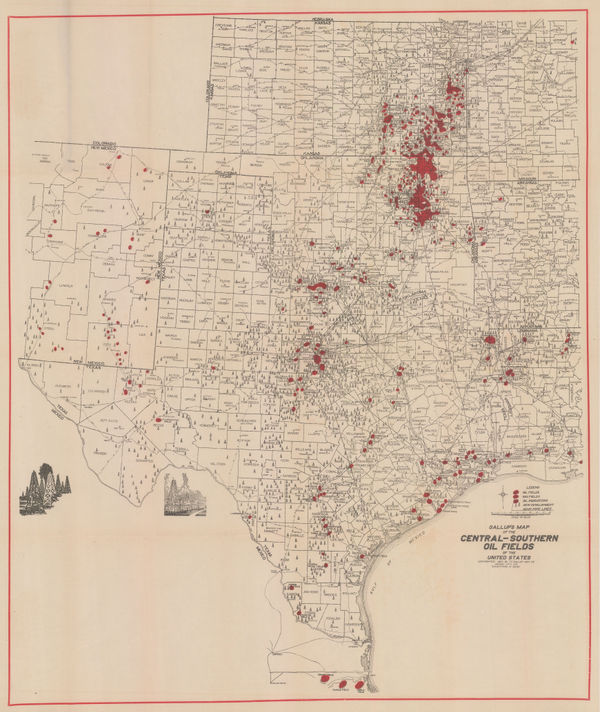
F.E. Gallup, Map of the Central-Southern Oil Fields, 1920£ 3,450.00
-
Map of the Petrolia Gas Fields Texas, 1920United States Geological Survey (USGS)Series: Washington, D.C.United States Geological Survey (USGS), Map of the Petrolia Gas Fields Texas, 1920£ 445.00
-
Relief Map of the Territory Served by the Lines of the Pacific Electric Railway in Southern California, 1920O.A. SmithO.A. Smith, Relief Map of the Territory Served by the Lines of the Pacific Electric Railway in Southern California, 1920£ 950.00
-
Fred Wild Company, Chicago, 1920£ 850.00
-
Rand, McNally & Co., New Commercial Atlas Map of Minnesota, 1920 c.£ 345.00
-
Clason Map Co., Prospector's Guide of Colorado, 1920 c.£ 425.00
-
Rand, McNally & Co., New Commercial Atlas Map of Arkansas, 1920 c.£ 245.00
-
William Olsen, Washington - The Beautiful Capital of the Nation, 1923£ 1,450.00
-
Nic Tengg, Map of the City of San Antonio, 1924£ 2,250.00
-
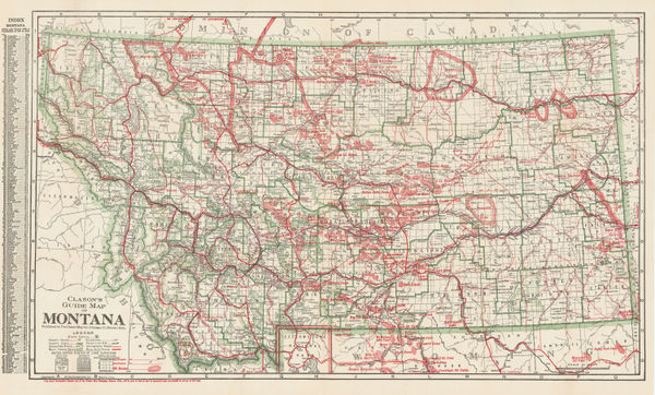
Clason Map Co., Guide Map of Montana, 1925£ 575.00
-
Redfield-Kendrick Odell Co., Sunrise Trails on Long Island, 1926£ 545.00
-
Map to Illustrate Major E.W. Nesham's Paper on the Alaska Boundary Demarcation, 1927Royal Geographical Society (RGS)Series: LondonRoyal Geographical Society (RGS), Map to Illustrate Major E.W. Nesham's Paper on the Alaska Boundary Demarcation, 1927£ 85.00
-
Federal Lithograph Company, Federal Map of Detroit and environs, 1927£ 485.00
-
Frederic M. Thrasher, Chicago's Gangland, 1927 c.£ 2,950.00
-
Arthur B. Suchy, The Heart of Cleveland Ohio, 1928£ 495.00
-
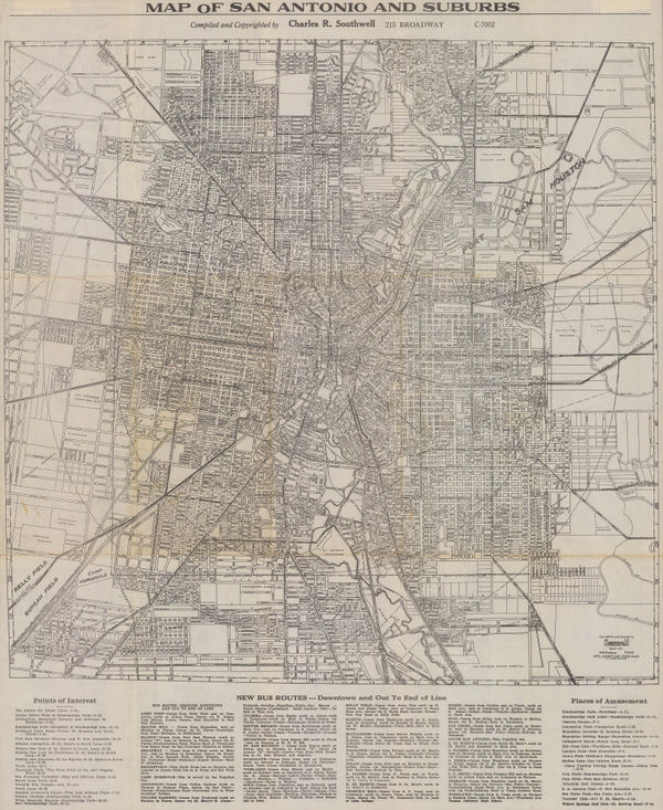
Charles R. Southwell, Map of San Antonio and Suburbs, 1928 c.£ 595.00
-
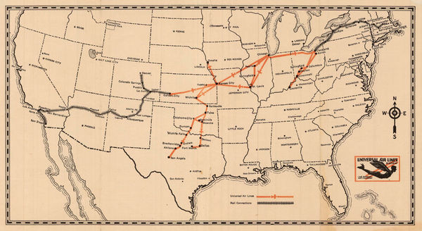
Universal Aviation, Universal Air Lines System, 1929£ 445.00
-
A. H. Guillot and L. J. Adam, New Orleans, 1929£ 875.00
-
Gerald Allen Eddy, The Ranchos of Los Angeles County, 1929£ 525.00
-
National Map Company, National Street Map of the Pittsburgh Area, 1930£ 1,750.00
-
California State Automobile Association, North Bay Counties, 1930 c£ 395.00
-
Rand, McNally & Co., A New Street Number Guide Map of Chicago and Suburbs, 1930 c.£ 525.00
-
Clason Map Co., Clason's Guide Map of California and Nevada, 1930 c.£ 645.00
-
Kroll Map Co., Guide Map to Seattle, 1930 c.£ 725.00
-
Boulder Chamber of Commerce, City Map - Boulder, Colorado, 1930 c.£ 125.00
-
Turzak & Chapman, Chicago USA, 1931£ 2,500.00
-
Nathan Mayo, Historical Map of Florida, 1931£ 285.00
-
Elmer & Berta Hader, Colorado and Wyoming, 1932£ 95.00
-
Elmer & Berta Hader, Nevada and Utah, 1932£ 85.00
-
Elmer & Berta Hader, Kansas and Nebraska, 1932£ 85.00
-
Elmer & Berta Hader, Kentucky and Tennessee, 1932£ 95.00
-
-
E. F. Hill, Map of the City of Santa Barbara, 1934£ 375.00
-
Ernest Dudley Chase, The United States of America, 1935£ 1,450.00
-
Schwabacher-Frey, California & Nevada, 1935£ 195.00
-
Mississippi Coast Hotel Association, The Gulf Coast of Mississippi, 1935 (c.)£ 180.00
-
California State Automobile Association, California, 1935 c£ 750.00
-
Buohl's Illustrated Map and Guide to Tour The Gettysburg Battlefield, 1936George W. BuohlSeries: Gettysburg, PAGeorge W. Buohl, Buohl's Illustrated Map and Guide to Tour The Gettysburg Battlefield, 1936£ 250.00
-
Charles Owens, California Official Tourist Picture Map, 1936£ 495.00
-
A Slightly Cockeyed map of that slightly Cockeyed Community Hollywood, 1937John GrothSeries: Los AngelesJohn Groth, A Slightly Cockeyed map of that slightly Cockeyed Community Hollywood, 1937£ 950.00
-
Parker Edwards, Hawaiian Islands, 1937£ 850.00
-
Ernest Dudley Chase, Boston (Massachusetts) and Vicinity, 1938£ 950.00
-
G. Frank Hooker, Map of the City of Cambridge, 1938£ 495.00
-
-
H. M. Gousha & Co, Street Map of Los Angeles, 1938£ 575.00
-
Redwood Empire Association, Northern California, 1938£ 285.00
-
Stuart F. Ball, Pictorial Map of Cincinnati, 1938£ 345.00
-
J. Foster Ashburn, Chamber of Commerce Map of Dallas Texas, 1938 c.£ 495.00
-
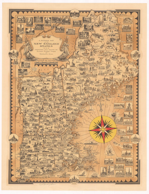
Ernest Dudley Chase, A Pictorial Map of the New England States, 1939£ 1,250.00
-
Kohnke Printing Co., Map of the City and County of San Francisco, 1939£ 785.00
-
Hagstrom Co. Inc., New York and Routes to the New York World's Fair, 1939£ 325.00
-
Ernest Dudley Chase, Pictorial Map of Manhattan, 1939£ 1,800.00
-
Hagstrom Co. Inc., New York World's Fair by Subway and Automobile, 1939£ 495.00
-
Mitt Schenkofsky, Merry-maker's Map of San Francisco, 1940£ 2,950.00
-
Ruth Taylor, San Francisco, 1940£ 295.00
-
Rand, McNally & Co., Miami Beach, 1940 (c.)£ 950.00
-
Hagstrom Co. Inc., Map of New York Theatres, Hotels, Shopping District, 1940 c£ 495.00
-
Thomas Bros, Highway Map of California, 1940 c£ 445.00
-
Ruth Taylor, Wine Map of California, 1940 c.£ 1,800.00
-
Arthur B. Suchy, Cayo Hueso - Key West, Florida, 1941 c.£ 425.00
-
British Admiralty, Cape San Blas to Vermilion Bay, 1942£ 750.00
-
British Admiralty, North America East Coast - Delaware Bay to Florida Strait, 1942£ 950.00
-
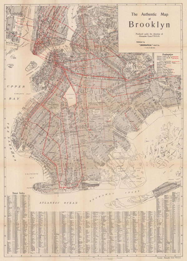
Geographia Map Co., The Authentic Map of Brooklyn, 1942£ 1,350.00
-
Charles R. Southwell, New Map of Greater San Antonio, 1942 c.£ 950.00
-
Souvenir Map and Guide to Starland Estates and Mansions... A Fascinating Trip Through Movieland, 1943Wesley G. LakeSeries: Los AngelesWesley G. Lake, Souvenir Map and Guide to Starland Estates and Mansions... A Fascinating Trip Through Movieland, 1943£ 1,350.00
-
The Seamen's Bank for Savings: Rapid Transit map of Greater New York, 1943General Drafting Co.Series: New YorkGeneral Drafting Co., The Seamen's Bank for Savings: Rapid Transit map of Greater New York, 1943£ 325.00
-
Dade County Newsdealer's Supply Co., Miami & Miami Beach, 1943£ 375.00
-
J. Foster Ashburn, Ashburn's Fort Worth, Tex, 1943 c£ 295.00


Page
14
of 16