-
 Dawes Commission, Indian Territory Showing Railroad Systems, 1904£ 225.00
 -
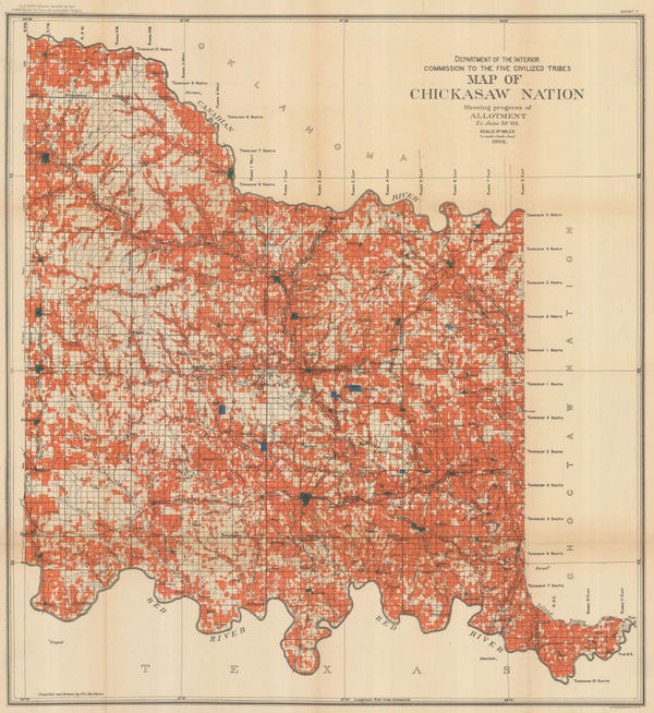
Dawes Commission, Map of Chickasaw Nation Showing progress of Allotment, 1904£ 450.00
-
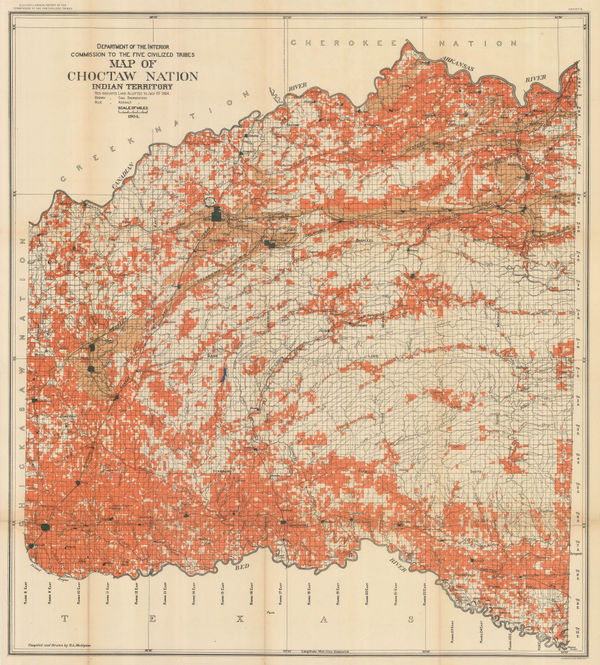
Dawes Commission, Map of Choctaw Nation, Indian Territory, 1904£ 450.00
-
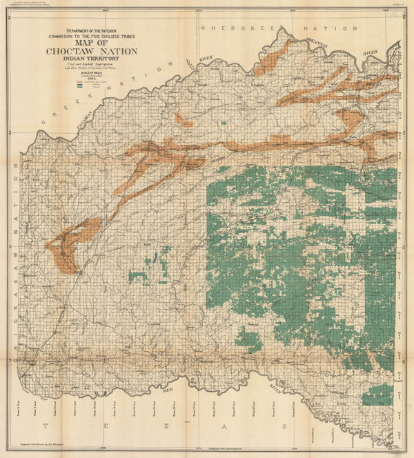
Map of Choctaw Nation. Indian Territory, Coal and Asphalt Segregation, 1904Dawes CommissionSeries: Washington, D.C.Dawes Commission, Map of Choctaw Nation. Indian Territory, Coal and Asphalt Segregation, 1904£ 450.00
-
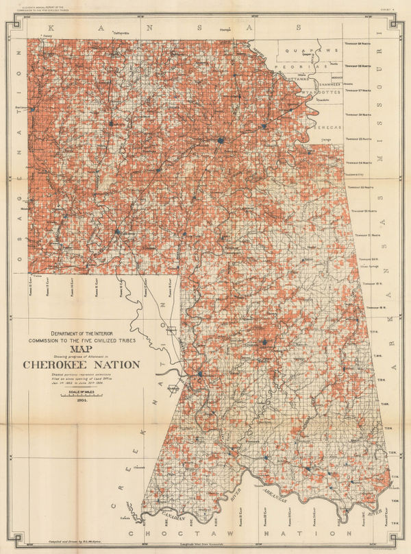
Dawes Commission, Map Showing Progress of Allotment in Cherokee Nation, 1904£ 375.00
-
Columbus Lithograph, Railroad Map of Ohio, 1904£ 295.00
-
The Position of the Main Ground-Water Table on Long Island, New York, 1904United States Geological Survey (USGS)Series: Washington, D.C.United States Geological Survey (USGS), The Position of the Main Ground-Water Table on Long Island, New York, 1904£ 495.00
-
Rand, McNally & Co., Colorado, 1904£ 395.00
-
Karl Baedeker, Savannah, 1904£ 68.00
-
General Land Office (GLO), Map of the Territory of Hawaii, 1905£ 885.00
-
United States Geological Survey (USGS), Two-Sheet Chart of Nantucket, 1905£ 525.00
-
Geographical Publishing Co., Intermediate Series: United States, 1906£ 575.00
-
Hawaiian Government Survey, Oahu - Hawaiian Islands, 1906£ 4,450.00
-
Rand, McNally & Co., Oklahoma and Indian Territory, 1906£ 175.00
-
Rand, McNally & Co., Texas, 1906£ 495.00
-
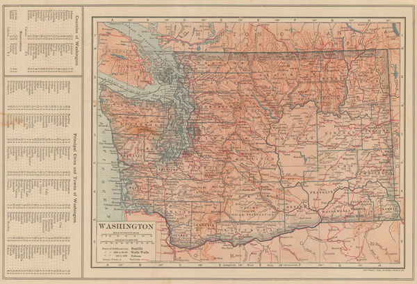
Dodd, Mead & Co., Washington, 1906£ 95.00
-
C. N. Hoover, Map of the City of Denver, 1906£ 950.00
-
Map Showing Indian Reservations within the Limits of the United States, 1907Francis Ellington LeuppSeries: Washington, D.C.Francis Ellington Leupp, Map Showing Indian Reservations within the Limits of the United States, 1907£ 945.00
-
Rand McNally, Kentucky, 1907£ 395.00
-
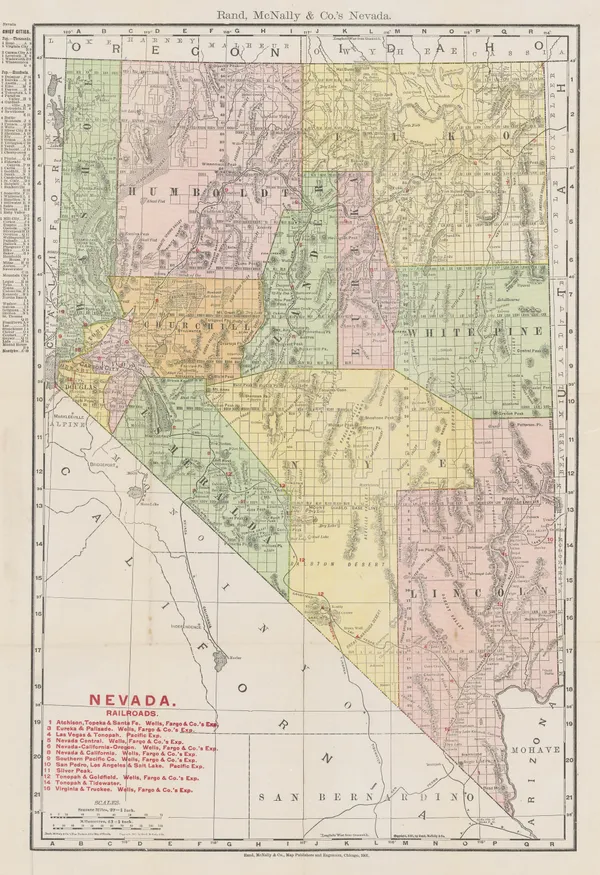
Rand, McNally & Co., New Commercial Atlas Map of Nevada, 1907£ 195.00
-
Rand, McNally & Co., West Virginia, 1907£ 175.00
-
W. & A.K. Johnston, United States (S.E.), 1908£ 125.00
-
Richard Holmes Laurie, Honolulu Harbour, 1908£ 145.00
-
Karl Baedeker, Cincinnati, 1909£ 44.00
-
Karl Baedeker, Indianapolis, 1909£ 44.00
-
Karl Baedeker, Minneapolis, 1909£ 52.00
-
Karl Baedeker, New Haven, 1909£ 42.00
-
Karl Baedeker, Salt Lake City, 1909£ 42.00
-
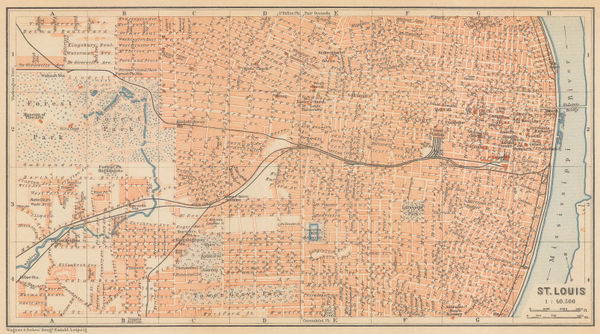
Karl Baedeker, St. Louis, 1909£ 72.00
-
Karl Baedeker, St. Paul, 1909£ 38.00
-
Rand, McNally & Co., The Soash Special, 1909£ 1,850.00
-
Karl Baedeker, Colorado Springs - Pike's Peak, 1909£ 58.00
-
Karl Baedeker, Grand Canyon, 1909£ 52.00
-
Karl Baedeker, Wyoming, 1909£ 48.00
-
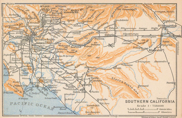
Karl Baedeker, Southern California, 1909£ 68.00
-
Karl Baedeker, New York, 1909£ 98.00
-
Karl Baedeker, Philadelphia, 1909£ 85.00
-
Karl Baedeker, Northern California, 1909£ 88.00
-
Karl Baedeker, Vicinity of New York, 1909£ 58.00
-
Karl Baedeker, Newport, Rhode Island, 1909£ 65.00
-
Karl Baedeker, Los Angeles, 1909£ 125.00
-
Karl Baedeker, Chicago, 1909£ 78.00
-
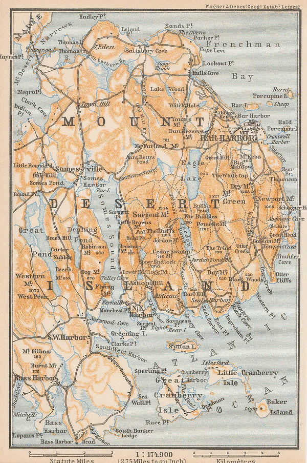
Karl Baedeker, Mount Desert Island, 1909£ 58.00
-
Karl Baedeker, Richmond, 1909£ 78.00
-
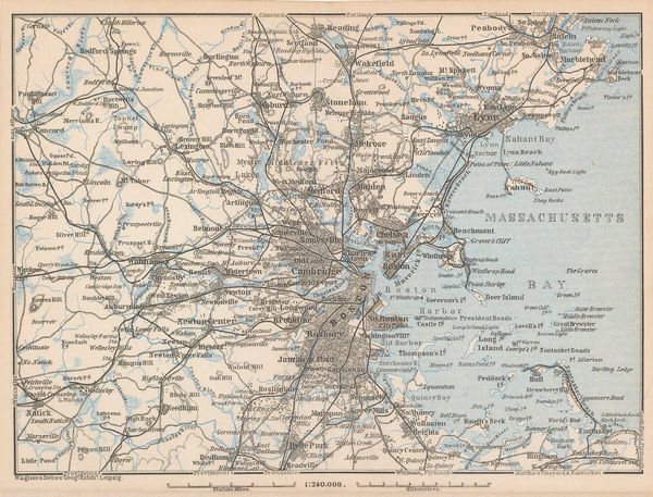
Karl Baedeker, Massachusetts Bay, 1909£ 58.00
-
Karl Baedeker, White Mountains and Franconia Mountains, 1909£ 58.00
-
Karl Baedeker, Brooklyn, 1909£ 98.00
-
Karl Baedeker, Buffalo, 1909£ 65.00
-
Karl Baedeker, Boston, 1909£ 88.00
-
Karl Baedeker, Detroit, 1909£ 75.00
-
Karl Baedeker, Pittsburgh and Allegheny, 1909£ 68.00
-
Karl Baedeker, The Grand Canyon, 1909£ 85.00
-
Karl Baedeker, Boston, 1909£ 115.00
-
Karl Baedeker, San Francisco , 1909£ 195.00
-
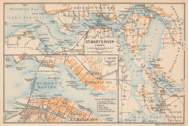
Karl Baedeker, Sault Ste. Marie, 1909£ 48.00
-
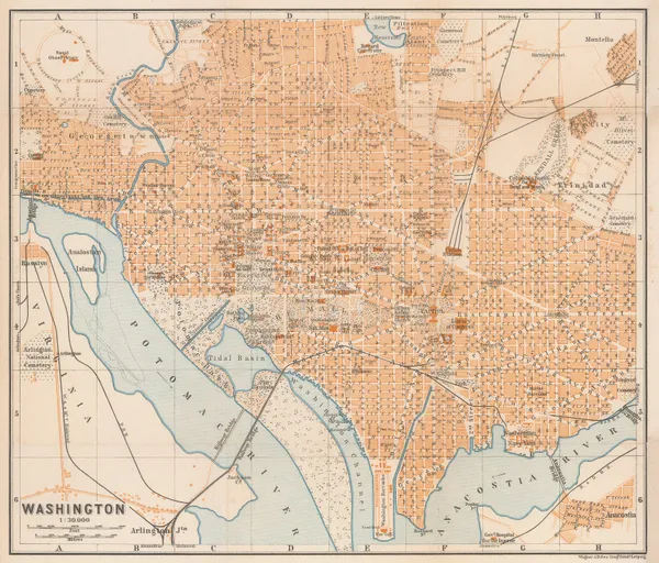
Karl Baedeker, Washington, 1909£ 185.00
-
Karl Baedeker, St. Augustine, 1909£ 86.00
-
Karl Baedeker, Denver, 1909£ 86.00
-
Karl Baedeker, Gettysburg, 1909£ 68.00
-
Karl Baedeker, Northern Florida, 1909 c.£ 55.00
-
Old Mill Cigarettes, [New Mexico], 1910£ 75.00
-
E. P. Noll & Co., New Official Guide Map of Philadelphia, 1910£ 675.00
-
I. P. Berthrong, Territory of Arizona, 1910£ 525.00
-
O.P. Anderson, Map of Puget Sound Country, 1910£ 2,750.00
-
Enciclopedia Segui, Boston, 1910 (c.)£ 125.00
-
Old Mill Cigarettes, Missouri, 1910 c.£ 75.00
-
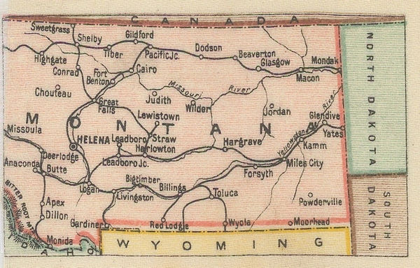
Old Mill Cigarettes, Montana, 1910 c.£ 65.00
-
Old Mill Cigarettes, [Nebraska], 1910 c.£ 68.00
-
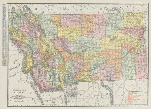
Rand, McNally & Co., Montana, 1910 c.£ 465.00
-
George Philip & Son Ltd., Industrial North America with Communications, 1910 c.£ 175.00
-
Enciclopedia Segui, Chicago, 1910 c.£ 125.00
-
Rand, McNally & Co., Oregon, 1911£ 345.00
-
Marcel Couttreau & H. le Chartier, Hawaii, 1911£ 92.00
-
Rand, McNally & Co., Wyoming, 1911£ 245.00
-
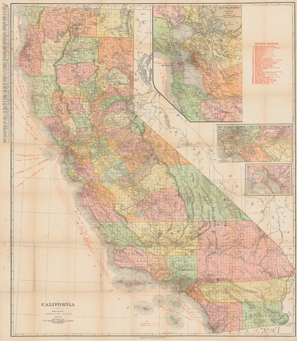
Rand McNally, California, 1911£ 825.00
-
Joseph Meyer, Saint-Louis, 1912£ 44.00
-
United States and Mexico - Sketch Map of part of Sonora and Arizona, 1912Royal Geographical Society (RGS)Series: LondonRoyal Geographical Society (RGS), United States and Mexico - Sketch Map of part of Sonora and Arizona, 1912£ 185.00
-
Rand, McNally & Co., City and County of San Francisco, 1912£ 550.00
-
Rand, McNally & Co., Arizona, 1912£ 475.00
-
C.S. Hammond & Co., A Guide to Jewish New York, 1912 c.£ 1,950.00


![Old Mill Cigarettes, [New Mexico], 1910](https://static-assets.artlogic.net/w_600,c_limit,f_auto,fl_lossy,q_auto/artlogicstorage/themaphouse/images/view/9182d82c7c077ee10aef250e19d3016bj/themaphouse-old-mill-cigarettes-new-mexico-1910.jpg)


![Old Mill Cigarettes, [Nebraska], 1910 c.](https://static-assets.artlogic.net/w_600,c_limit,f_auto,fl_lossy,q_auto/artlogicstorage/themaphouse/images/view/719da3221d805e611ef458264a9f9958j/themaphouse-old-mill-cigarettes-nebraska-1910-c..jpg)


Page
13
of 16