-
 General Land Office (GLO), Diagram of the State of Illinois, 1845£ 120.00
 -
Map of an Exploring Expedition to the Rocky Mountains in the Year 1842 and to Oregon & North California in the Years 1845-44, 1845John C. FremontSeries: Washington, D.C.John C. Fremont, Map of an Exploring Expedition to the Rocky Mountains in the Year 1842 and to Oregon & North California in the Years 1845-44, 1845£ 3,950.00
-
General Land Office (GLO), Map of the State of Florida, 1845£ 725.00
-
Joseph Meyer, Kentucky, 1845£ 275.00
-
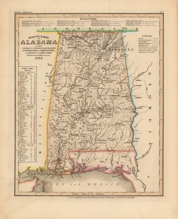
Joseph Meyer, Alabama, 1845£ 265.00
-
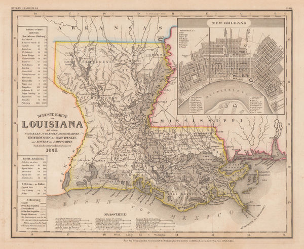
Joseph Meyer, Louisiana and New Orleans, 1845£ 325.00
-
Joseph Meyer, Maine, 1845£ 255.00
-
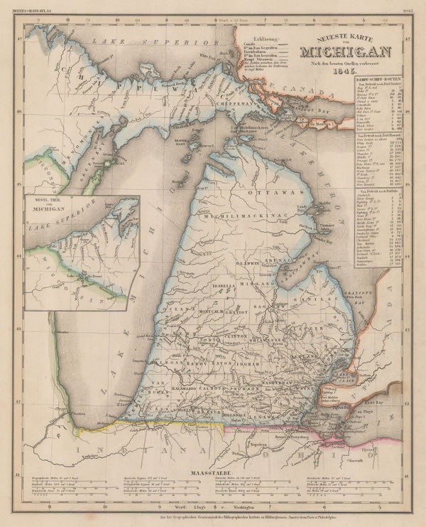
Joseph Meyer, Michigan, 1845£ 345.00
-
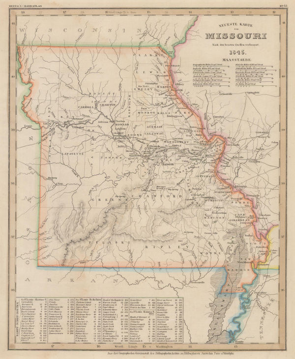
Joseph Meyer, Missouri, 1845£ 160.00
-
Joseph Meyer, German map of Ohio, 1845£ 245.00
-
Joseph Meyer, Pennsylvania, 1845£ 275.00
-
George Frederick Cruchley, North America, 1845£ 120.00
-
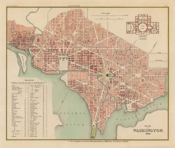
Joseph Meyer, Street plan of Washington D. C., 1845£ 745.00
-
General Land Office (GLO), Sketch of the Public Surveys of Michigan, 1845£ 155.00
-
George Frederick Cruchley, United States, 1845£ 140.00
-
Joseph Meyer, Illinois, 1845£ 325.00
-
-
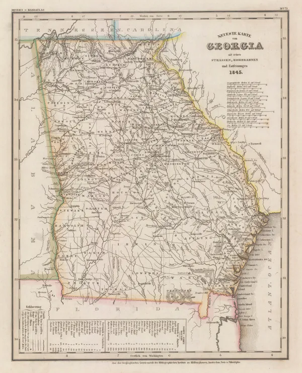
Joseph Meyer, Georgia, 1845£ 325.00
-
Joseph Meyer, Tennessee, 1845£ 285.00
-
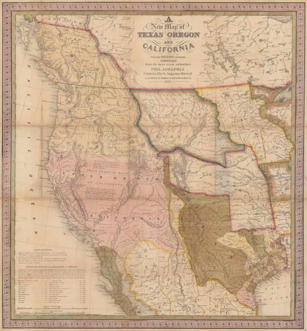
Carl Flemming, Republic of Texas, 1845 c£ 1,850.00
-
Samuel Augustus Mitchell, City of New-York, 1845 c.£ 695.00
-
Joseph Meyer, Philadelphia, 1845 c.£ 345.00
-
-
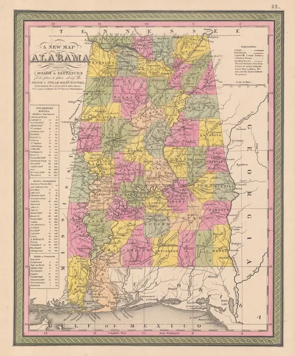
Samuel Augustus Mitchell, A New Map of Alabama, 1846£ 395.00
-
Samuel Augustus Mitchell, A New Map of Arkansas, 1846£ 180.00
-
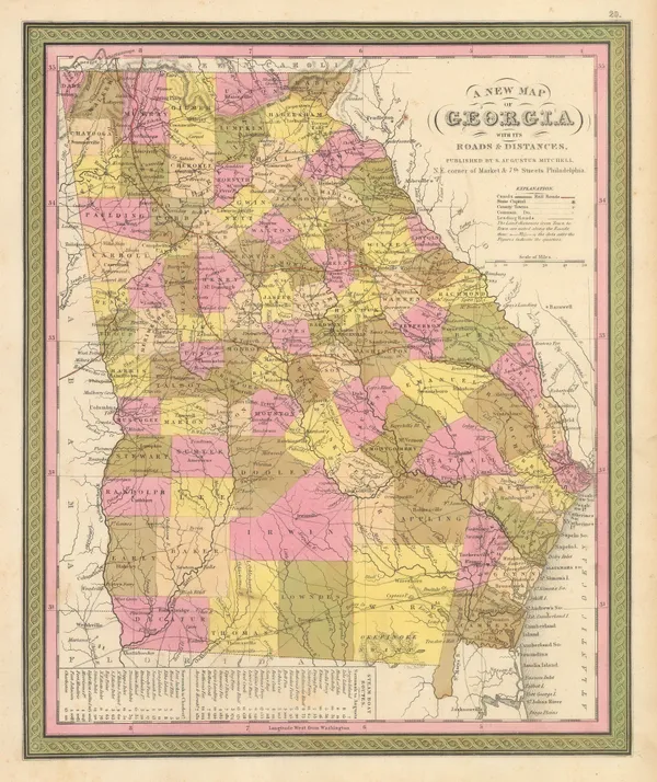
Samuel Augustus Mitchell, A New Map of Georgia with its Roads & Distances, 1846£ 485.00
-
Samuel Augustus Mitchell, A New Map of Indiana, 1846£ 275.00
-
Samuel Augustus Mitchell, A New Map of Kentucky, 1846£ 375.00
-
Samuel Augustus Mitchell, A New Map of Maine, 1846£ 445.00
-
Samuel Augustus Mitchell, A New Map of Maryland and Delaware, 1846£ 395.00
-
Samuel Augustus Mitchell, A New Map of Michigan, 1846£ 485.00
-
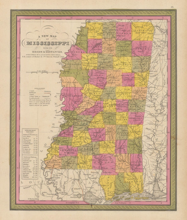
Samuel Augustus Mitchell, A New Map of Mississippi, 1846£ 145.00
-
Samuel Augustus Mitchell, A New Map of Ohio, 1846£ 225.00
-
A New Map of Pennsylvania with its Canals, Rail-Roads & c., 1846Samuel Augustus MitchellSeries: PhiladelphiaSamuel Augustus Mitchell, A New Map of Pennsylvania with its Canals, Rail-Roads & c., 1846£ 275.00
-
Joseph Meyer, Connecticut, 1846£ 285.00
-
Joseph Meyer, New Hampshire and Vermont, 1846£ 285.00
-
Samuel Augustus Mitchell, Philadelphia, 1846£ 295.00
-
Joseph Meyer, Texas, 1846£ 2,650.00
-
Samuel Augustus Mitchell, United States, 1846£ 225.00
-
Joseph Meyer, Massachusetts and Rhode Island, 1846£ 195.00
-
Samuel Augustus Mitchell, Connecticut, 1846 c.£ 375.00
-
Samuel Augustus Mitchell, A New Map of Louisiana, 1847£ 395.00
-
E. & G.W. Blunt, Delaware Bay, 1847£ 66.00
-
P.M. McGill, Map of Fort Hill, 1847£ 825.00
-
E. & G.W. Blunt, Pensacola Harbour, 1847£ 88.00
-
Henry Teesdale, United States, 1847£ 345.00
-
Samuel Augustus Mitchell, A New Map of Tennessee, 1847Sold
-
Samuel Augustus Mitchell, Map of the United States, 1847 (c.)£ 625.00
-
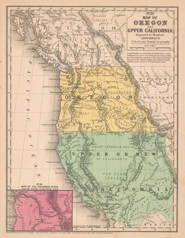
Samuel Augustus Mitchell, Map of Oregon and Upper California, 1847 (c.)£ 1,150.00
-
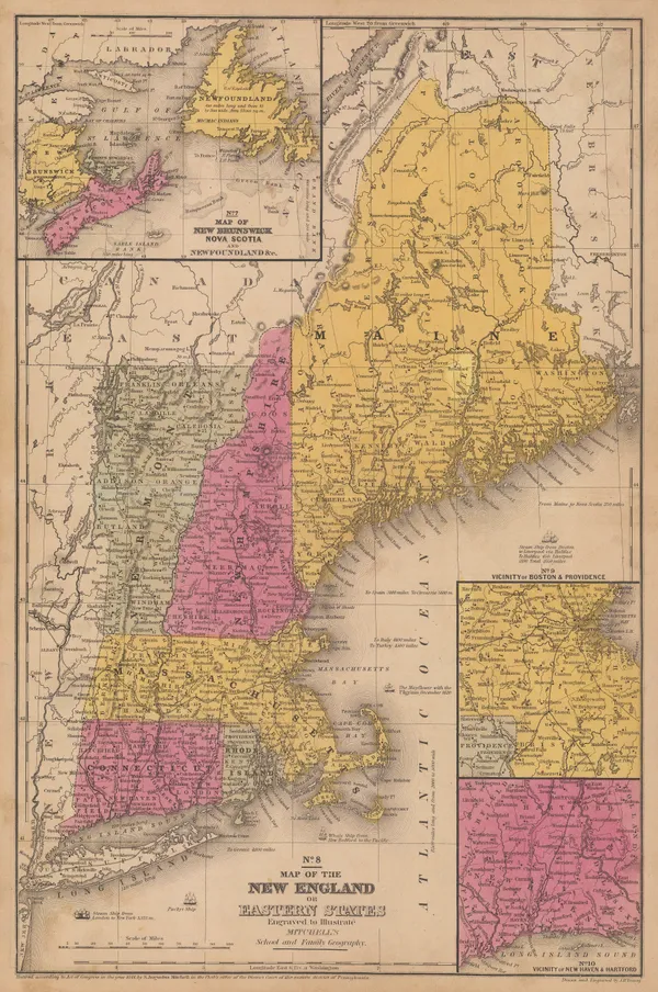
Samuel Augustus Mitchell, Map of the New England or Eastern States, 1847 (c.)£ 195.00
-
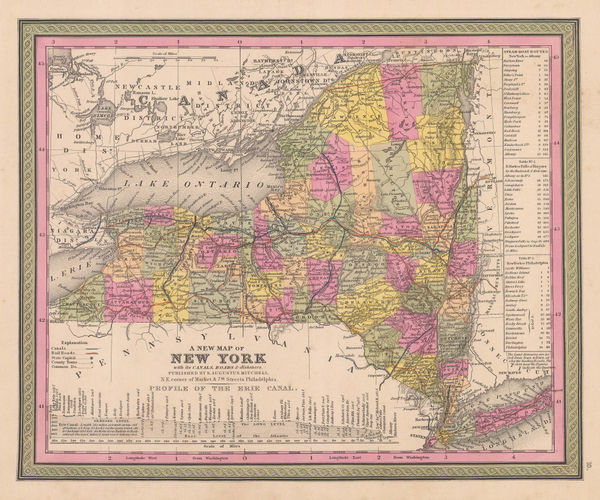
Samuel Augustus Mitchell, A New Map of New York, 1847 c.£ 395.00
-
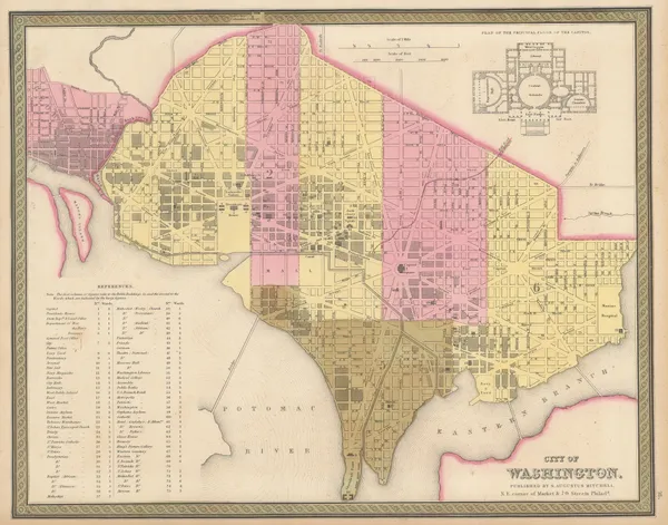
Samuel Augustus Mitchell, City of Washington, 1847 c.£ 495.00
-
Samuel Augustus Mitchell, Massachusetts and Rhode Island, 1847 c.£ 295.00
-
-
Jeremiah Greenleaf, Vermont and New Hampshire, 1848£ 165.00
-
Joseph Meyer, Bergsystem von Nord-America, 1848£ 295.00
-
A New Map of Illinois with its Proposed Canals, Roads, & Distances, 1849Samuel Augustus MitchellSeries: PhiladelphiaSamuel Augustus Mitchell, A New Map of Illinois with its Proposed Canals, Roads, & Distances, 1849£ 165.00
-
Samuel Augustus Mitchell, A New Map of South Carolina, 1849£ 475.00
-
Lt. George Horatio Derby, General Riley's Route, 1849£ 2,250.00
-
Samuel Augustus Mitchell, Iowa, 1849£ 345.00
-
Samuel Augustus Mitchell, Map of Texas from the Most Recent Authorities, 1849£ 1,895.00
-
Capt. John B. Pope, Map of the Territory of Minnesota, 1849£ 2,750.00
-
Samuel Augustus Mitchell, New Jersey, 1849£ 395.00
-
Samuel Augustus Mitchell, A New Map of the State of Illinois, 1850£ 150.00
-
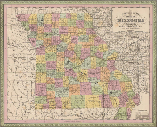
Samuel Augustus Mitchell, A New Map of the State of Missouri, 1850£ 185.00
-
General Chart - Farallones Entrance to the Bay of San Francisco, 1850Cadwalader RinggoldSeries: Washington, D.C.Cadwalader Ringgold, General Chart - Farallones Entrance to the Bay of San Francisco, 1850£ 1,950.00
-
Samuel Augustus Mitchell, Map of New Hampshire & Vermont, 1850£ 175.00
-
Lt. George Horatio Derby, Reconnaissance of the Colorado River, 1850£ 885.00
-
General Land Office (GLO), Sketch Map of the Public Surveys in Iowa Territory, 1850£ 125.00
-
General Land Office (GLO), Sketch of the Public Surveys of Michigan, 1850£ 155.00
-
The Sacramento Valley from the American River to Butte Creek, 1850Lt. George Horatio DerbySeries: Washington, D.C.Lt. George Horatio Derby, The Sacramento Valley from the American River to Butte Creek, 1850£ 2,250.00
-
General Land Office (GLO), South Florida, 1850£ 175.00
-
Samuel Augustus Mitchell, A New Map of Tennessee, 1850 c£ 485.00
-
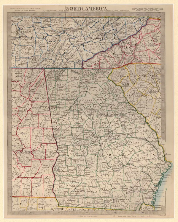
Society for the Diffusion of Useful Knowledge (SDUK), North America Sheet XII, 1850 c.£ 295.00
-
Selina Hall, United States, 1850 c.£ 275.00
-
John Tallis, United States, 1851£ 495.00
-
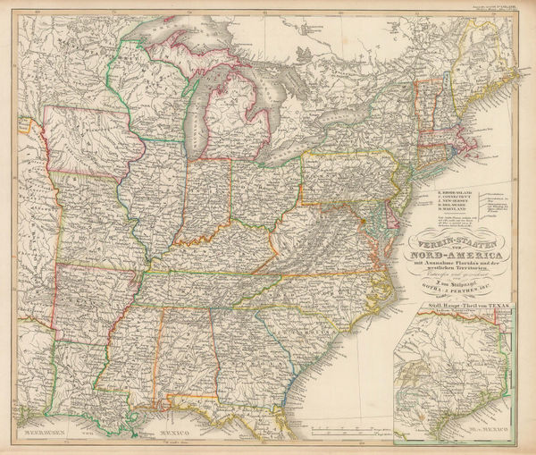
Justus Perthes, Eastern United States, 1851£ 125.00
-
Joseph Meyer, Neueste Karte von Maryland und Delaware, 1851£ 295.00
-
John Tallis, Boston, 1851£ 975.00
-
Benedetto Marzolla, Nuova California, 1851£ 2,200.00


Page
6
of 16