-
 O.W. Gray & Son, New Hampshire, 1881£ 195.00
 -
Justus Perthes, Topographical map of south western USA, 1881£ 275.00
-
O.W. Gray & Son, Vermont, 1881£ 225.00
-
O.W. Gray & Son, New Mexico and Arizona, 1881£ 275.00
-
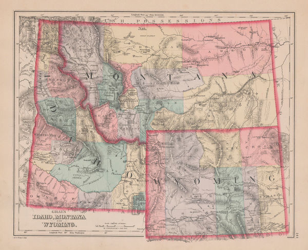
O.W. Gray & Son, Idaho, Montana and Wyoming, 1881£ 295.00
-
O.W. Gray & Son, Maine, 1881£ 245.00
-
O.W. Gray & Son, Colorado, 1881£ 395.00
-
Philetus W. Norris, Map of the Yellowstone National Park, 1881£ 725.00
-
County & Township Map of the States of Ohio and Indiana, 1882Samuel Augustus MitchellSeries: PhiladelphiaSamuel Augustus Mitchell, County & Township Map of the States of Ohio and Indiana, 1882£ 140.00
-
County and Township Map of the States of Iowa and Missouri, 1882Samuel Augustus MitchellSeries: PhiladelphiaSamuel Augustus Mitchell, County and Township Map of the States of Iowa and Missouri, 1882£ 140.00
-
County and Township Map of the States of Michigan and Wisconsin, 1882Samuel Augustus MitchellSeries: PhiladelphiaSamuel Augustus Mitchell, County and Township Map of the States of Michigan and Wisconsin, 1882£ 140.00
-
County and Township Map of Vermont and New Hampshire, 1882Samuel Augustus MitchellSeries: PhiladelphiaSamuel Augustus Mitchell, County and Township Map of Vermont and New Hampshire, 1882£ 165.00
-
County Map of the States of Arkansas, Mississippi and Louisiana, 1882Samuel Augustus MitchellSeries: PhiladelphiaSamuel Augustus Mitchell, County Map of the States of Arkansas, Mississippi and Louisiana, 1882£ 160.00
-
Letts & Son, Illinois with parts of Iowa, Missouri and Indianan, 1882£ 75.00
-
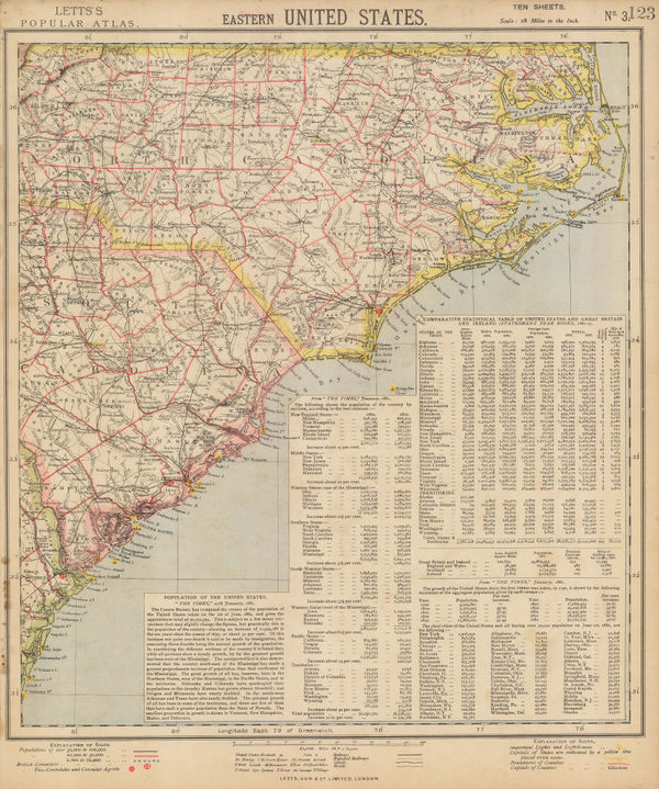
Letts & Son, Eastern United States, 1882£ 75.00
-
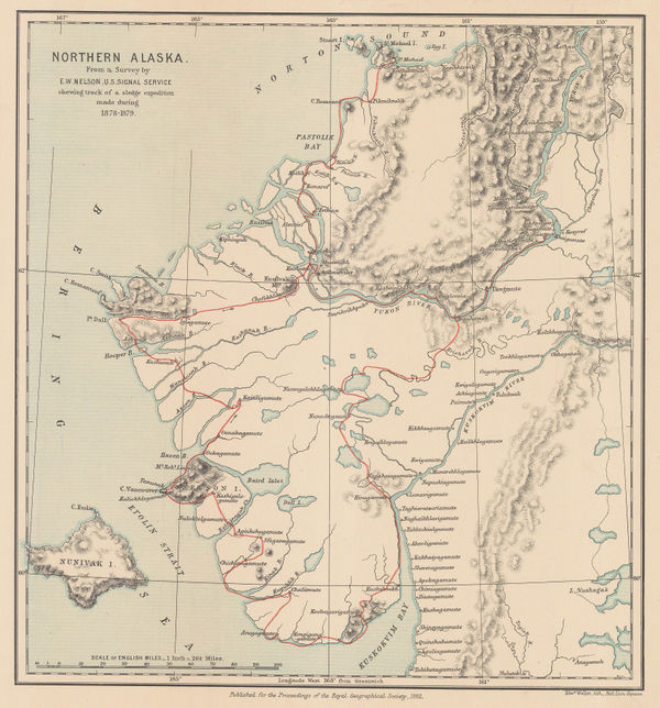
Royal Geographical Society (RGS), Northern Alaska, 1882£ 225.00
-
Henry Cuthbert Tunison, Massachusetts, Connecticut & Rhode Island, 1882£ 225.00
-
Henry Cuthbert Tunison, Florida, 1882£ 185.00
-
Henry Cuthbert Tunison, Virginia, Maryland, Delaware & West Virginia, 1882£ 95.00
-
Henry Cuthbert Tunison, Michigan, 1882£ 95.00
-
Henry Cuthbert Tunison, Kentucky, 1882£ 85.00
-
Henry Cuthbert Tunison, North Dakota, 1882£ 95.00
-
Henry Cuthbert Tunison, Alaska, 1882£ 95.00
-
Henry Cuthbert Tunison, Maine, 1882£ 95.00
-
Henry Cuthbert Tunison, Minnesota, 1882£ 95.00
-
Edward K. Godfrey, Historical Map Nantucket, 1882 c.£ 1,250.00
-
Letts & Son, Eastern United States, 1883£ 68.00
-
Wright & Polter, Map of Railroads of the State of Massachusetts, 1883£ 675.00
-
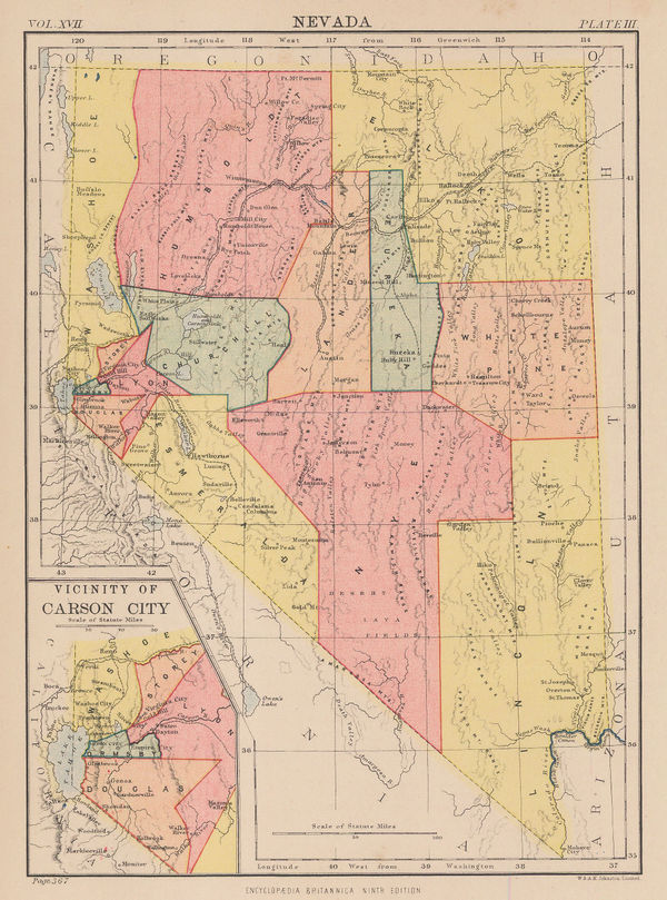
W. & A.K. Johnston, Nevada, 1883£ 65.00
-
A. Simon, Boston, 1884£ 495.00
-
Samuel Augustus Mitchell, County and Township Map of Dakota, 1884£ 58.00
-
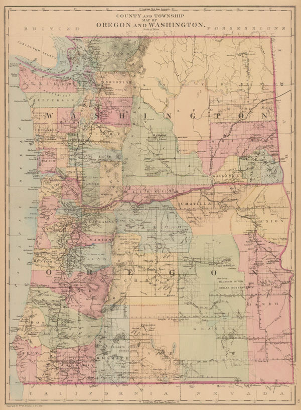
Samuel Augustus Mitchell, County and Township Map of Oregon and Washington, 1884£ 225.00
-
Samuel Augustus Mitchell, County Map of the State of New York, 1884£ 145.00
-
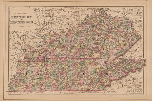
Samuel Augustus Mitchell, Kentucky and Tennessee, 1884£ 125.00
-
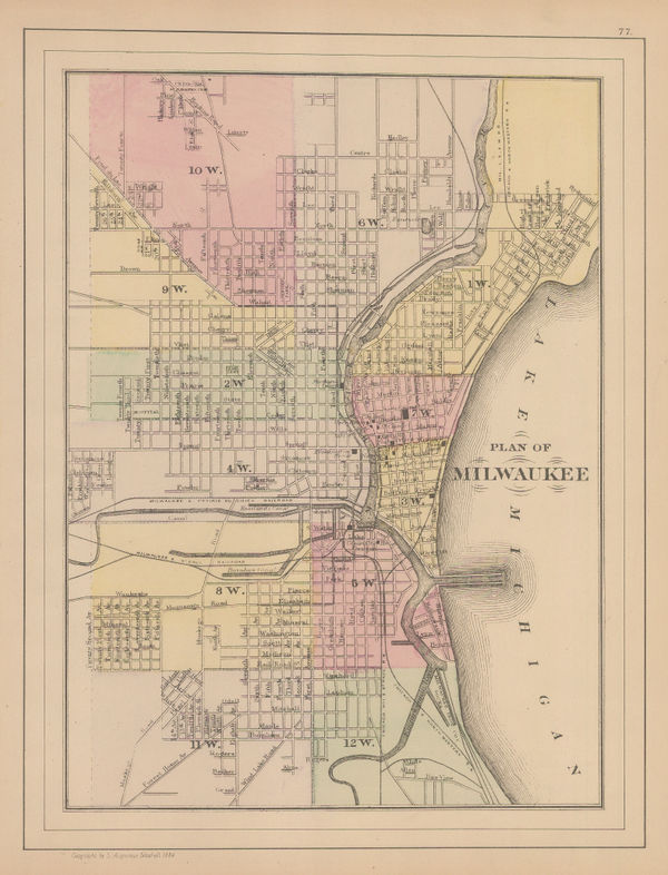
Samuel Augustus Mitchell, Plan of Milwaukee, 1884£ 62.00
-
Samuel Augustus Mitchell, Plan of the City of Philadelphia and Camden, 1884£ 165.00
-
General Land Office (GLO), State of Oregon, 1884£ 1,350.00
-
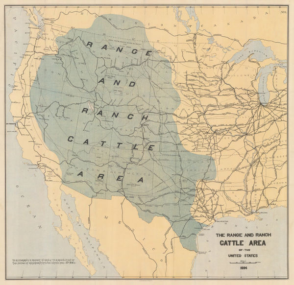
Julius Bien, The Range and Ranch Cattle Area of the United-States, 1884£ 1,650.00
-
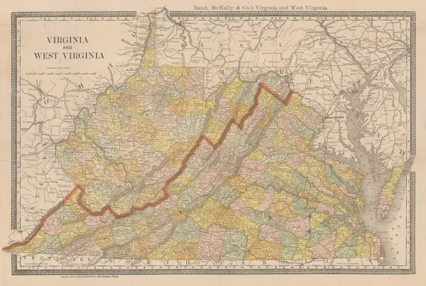
Rand, McNally & Co., Virginia and West Virginia, 1884£ 145.00
-
W. & A.K. Johnston, New York - City and Vicinity, 1884£ 125.00
-
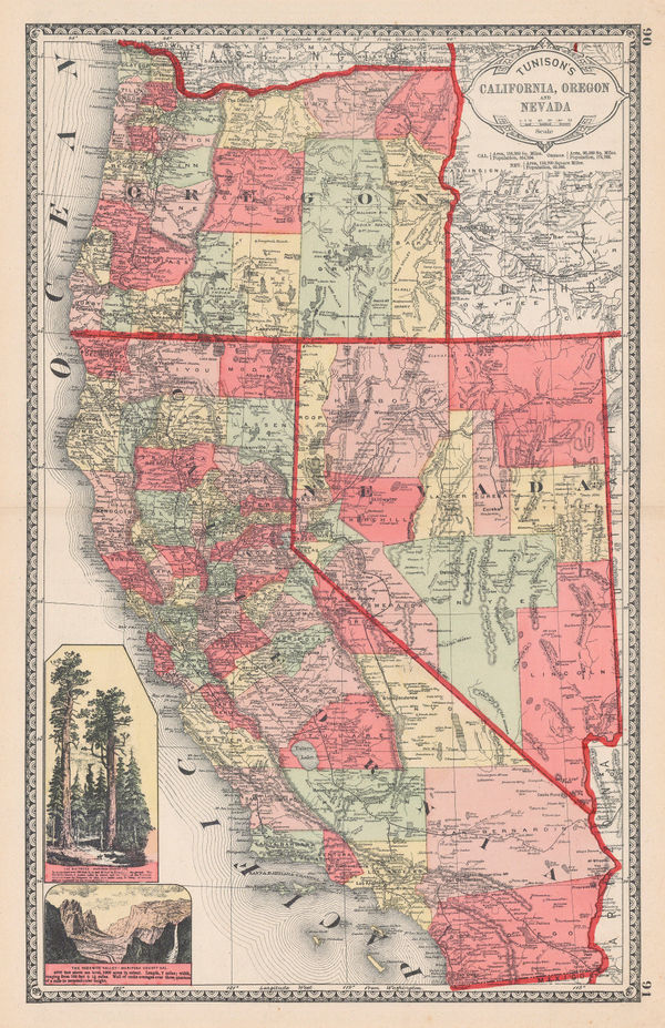
Henry Cuthbert Tunison, Tunison's California, Oregon, and Nevada, 1884£ 695.00
-
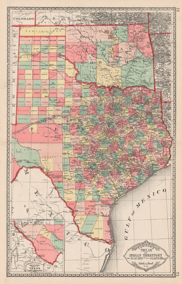
Henry Cuthbert Tunison, Tunison's Texas and Oklahoma, 1884£ 695.00
-
Samuel Augustus Mitchell, Plan of Cincinnati and vicinity, 1884 c.£ 64.00
-
Paul Brodie, Indian Reservations, 1885£ 950.00
-
Justus Perthes, Dakotas, Minnesota, Iowa, Nebraska and part of Wisconsin., 1885£ 85.00
-
Justus Perthes, [United States & Mexico], 1885£ 475.00
-
George W. Bacon, North America, 1885 (c.)£ 125.00
-
George W. Bacon, Western United States , 1885 (c.)£ 145.00
-
Henry Cuthbert Tunison, New Mexico, 1885 (c.)£ 125.00
-
J.G. Bartholomew, Eastern United States, 1886£ 42.00
-
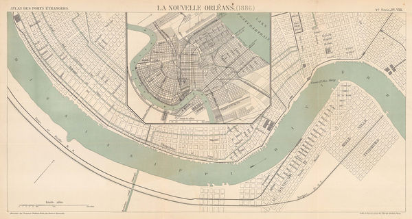
A. Simon, Chart of New Orleans harbour, 1886£ 345.00
-
A. Simon, New-York (1886), 1886£ 745.00
-
General Land Office (GLO), State of Arkansas, 1886£ 750.00
-
H.R. Page & Co., Washington Territory, 1886£ 850.00
-
H.R. Page & Co., Page's Map of Arizona, 1886£ 595.00
-
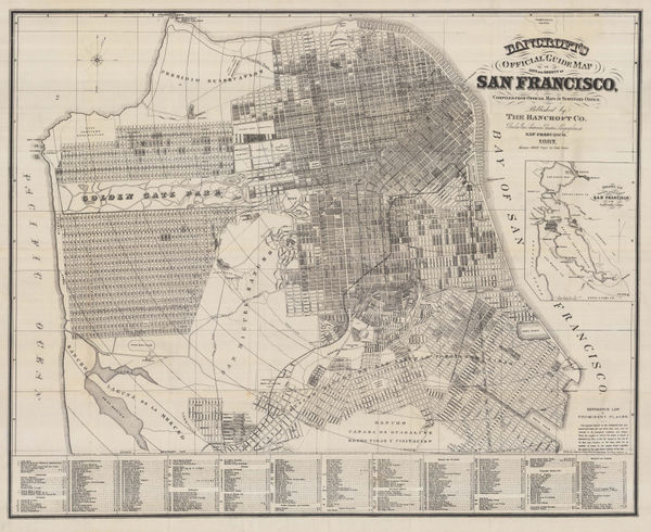
Bancroft's Official Guide Map of City and County San Francisco, 1887Bancroft Co.Series: San FranciscoBancroft Co., Bancroft's Official Guide Map of City and County San Francisco, 1887£ 1,850.00
-
Depot de la Marine, Chart of the coast from New Jersey to Florida, 1887£ 695.00
-
A. Simon, Charleston (1887), 1887£ 365.00
-
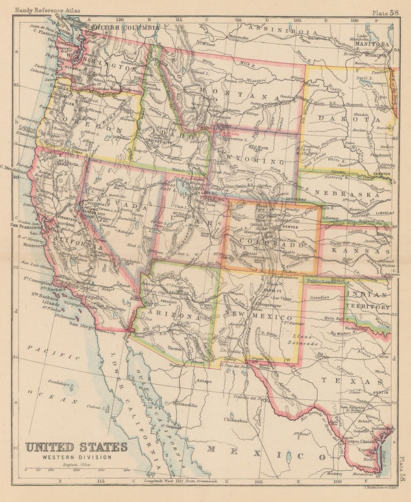
John Bartholomew, United States Western Division, 1887£ 62.00
-
J.G. Bartholomew, United States, 1887£ 50.00
-
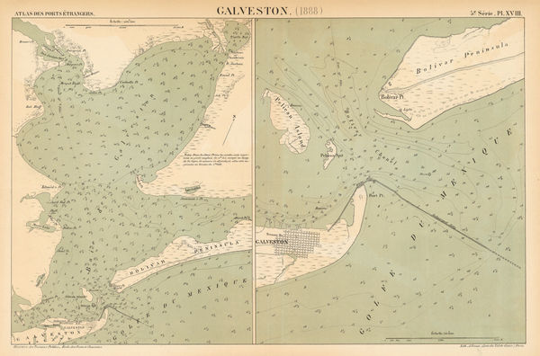
A. Simon, Galveston (1888), 1888£ 425.00
-
US Government, Galveston Bay, 1888£ 1,750.00
-
Lyman Brown, Lyman Brown's Seven Barks - Pictorial Map of the United States, 1888£ 695.00
-
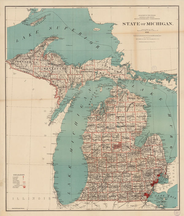
General Land Office (GLO), State of Michigan, 1888£ 985.00
-
Henry William Blair, New York City's Drinking Problem, 1888£ 1,250.00
-
Justus Perthes, Population map of the United States and Canada, 1888£ 325.00
-
G.W. & C.B. Colton & Co., Atchison, Topeka and Santa Fe Railroad System, 1889£ 595.00
-
Letts & Son, North and South Carolina, 1889£ 95.00
-
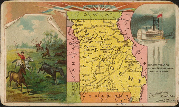
Arbuckle Brothers Company, Missouri, 1889£ 75.00
-
Arbuckle Brothers Company, Nebraska, 1889£ 96.00
-
Arbuckle Brothers Company, Utah, 1889£ 98.00
-
Arbuckle Brothers Company, Arizona, 1889£ 115.00
-
Arbuckle Brothers Company, [Delaware], 1889£ 98.00
-
Arbuckle Brothers Company, Idaho, 1889£ 88.00
-
Arbuckle Brothers Company, [Indiana], 1889£ 85.00
-
Arbuckle Brothers Company, [Iowa], 1889£ 88.00
-
Arbuckle Brothers Company, [Kentucky], 1889£ 95.00
-
Arbuckle Brothers Company, Massachusetts, 1889£ 145.00
-
Arbuckle Brothers Company, Mississippi, 1889£ 125.00
-
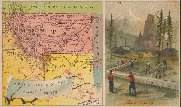
Arbuckle Brothers Company, Montana, 1889£ 98.00


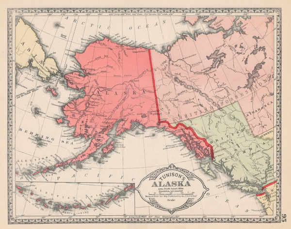


![Justus Perthes, [United States & Mexico], 1885](https://static-assets.artlogic.net/w_600,c_limit,f_auto,fl_lossy,q_auto/artlogicstorage/themaphouse/images/view/c6625ff623e11a6f202de768c609d824j/themaphouse-justus-perthes-united-states-mexico-1885.jpg)


![Arbuckle Brothers Company, [Delaware], 1889](https://static-assets.artlogic.net/w_600,c_limit,f_auto,fl_lossy,q_auto/artlogicstorage/themaphouse/images/view/36dbb3453e2d24c48e455fe425e5879fj/themaphouse-arbuckle-brothers-company-delaware-1889.jpg)

![Arbuckle Brothers Company, [Indiana], 1889](https://static-assets.artlogic.net/w_600,c_limit,f_auto,fl_lossy,q_auto/artlogicstorage/themaphouse/images/view/17e11fe399a207a6192514624b5af25aj/themaphouse-arbuckle-brothers-company-indiana-1889.jpg)
![Arbuckle Brothers Company, [Iowa], 1889](https://static-assets.artlogic.net/w_600,c_limit,f_auto,fl_lossy,q_auto/artlogicstorage/themaphouse/images/view/ae23a4380ff801538686cae1c4a69197j/themaphouse-arbuckle-brothers-company-iowa-1889.jpg)
![Arbuckle Brothers Company, [Kentucky], 1889](https://static-assets.artlogic.net/w_600,c_limit,f_auto,fl_lossy,q_auto/artlogicstorage/themaphouse/images/view/d12961894cb2a3ae523605877adf8b46j/themaphouse-arbuckle-brothers-company-kentucky-1889.jpg)


Page
10
of 16