-
 George Woolworth Colton, Florida, 1868£ 375.00
 -
Joseph Shannon, Map of New York City, 1868£ 1,750.00
-
Map of the Upper Part of the Island of Manhattan above eighty-sixth street arranged to illustrate the Battle of Harlem Heights, 1868Joseph ShannonJoseph Shannon, Map of the Upper Part of the Island of Manhattan above eighty-sixth street arranged to illustrate the Battle of Harlem Heights, 1868£ 395.00
-
-
Royal Geographical Society (RGS), Map of the Yukon, or Kwich-Pak River, 1868£ 245.00
-
Justus Perthes, Map of the Baja California Peninsula, 1868£ 325.00
-
Map of the United States of America, the British Provinces, Mexico and the West Indies, 1868 c.George Woolworth ColtonSeries: New YorkGeorge Woolworth Colton, Map of the United States of America, the British Provinces, Mexico and the West Indies, 1868 c.£ 2,850.00
-
Watson's New Map of the Western States Territories, Mexico, and Central America, 1869Gaylord WatsonSeries: New YorkGaylord Watson, Watson's New Map of the Western States Territories, Mexico, and Central America, 1869£ 4,500.00
-
Justus Perthes, Arctic Russia, Wrangel Island & the Bering Strait, 1869£ 125.00
-
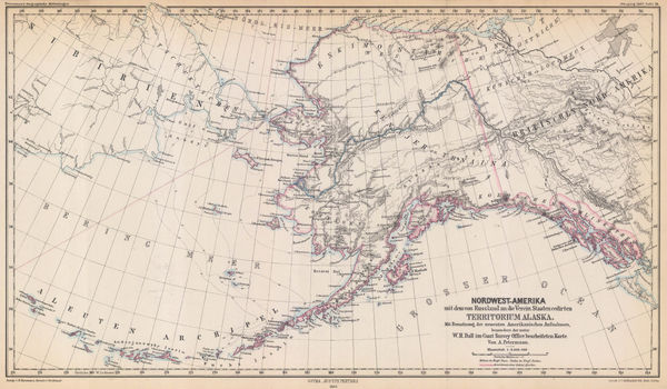
Justus Perthes, Alaska, 1869£ 295.00
-
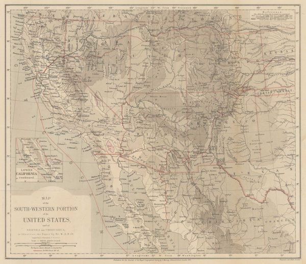
Map of the South-Western Portion of the United States, 1870Royal Geographical Society (RGS)Series: LondonRoyal Geographical Society (RGS), Map of the South-Western Portion of the United States, 1870£ 375.00
-
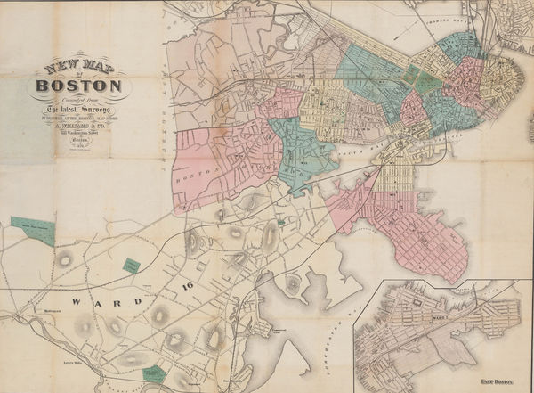
A. Williams & Co., New Map of Boston from the Latest Surveys, 1870£ 1,450.00
-
James Wyld, The United States, 1870 (c.)£ 1,250.00
-
Alvin J. Johnson, Western States of the USA, 1870 c£ 645.00
-
Heinrich C. Kiepert, Die Vereinigten Staaten von Nord America nebst Canada, 1870 c.£ 445.00
-
Geological Map of the Lead Region in the States of Wisconsin, Illinois and Iowa, 1870 c.J.D. WhitneyJ.D. Whitney, Geological Map of the Lead Region in the States of Wisconsin, Illinois and Iowa, 1870 c.£ 585.00
-
Ferdinand Hayden, Map of the Shoshone Geysers, 1870 c.£ 395.00
-
Archibald Fullarton, Southeast United States, 1870 c.£ 78.00
-
Archibald Fullarton, United States - The North Central Section, 1870 c.£ 75.00
-
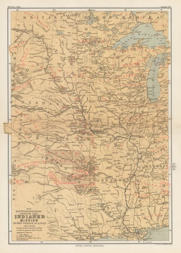
Justus Perthes, Indigenous Map of Central and Midwest USA, 1871£ 125.00
-
Spanish Admiralty, Spanish Admiralty chart of the Chesapeake Bay, 1871£ 1,450.00
-
Alvin J. Johnson, New York and Brooklyn, 1872 c£ 825.00
-
Samuel Augustus Mitchell, County Map of Florida, 1874£ 145.00
-
Samuel Augustus Mitchell, County Map of the State of Illinois, 1874£ 115.00
-
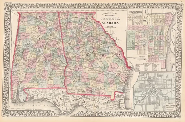
Samuel Augustus Mitchell, County map of the States of Georgia and Alabama, 1874£ 195.00
-
D. Appleton & Company, Map of Boston, 1874£ 375.00
-
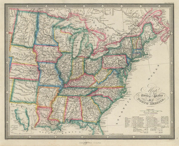
James Wyld, Map of the United States of North America, 1874£ 185.00
-
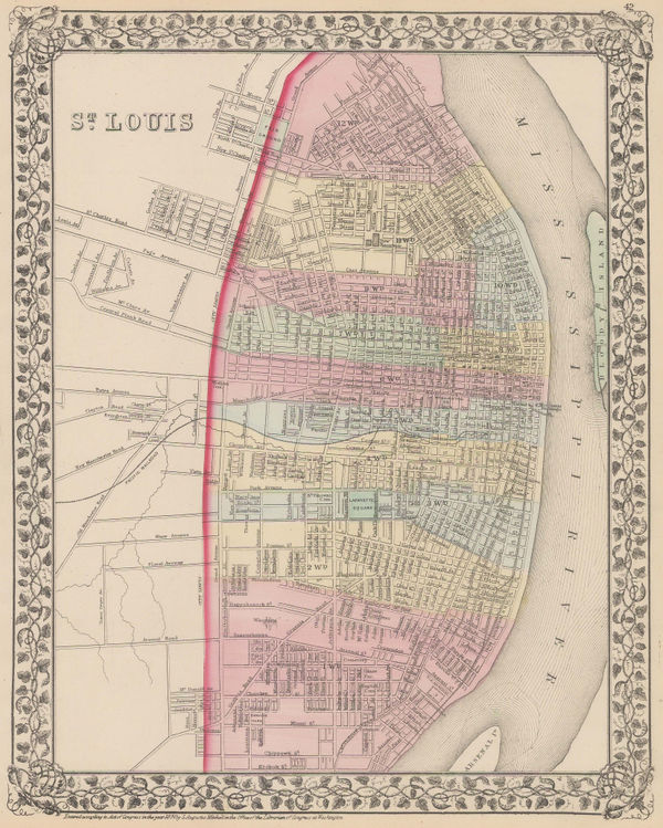
Samuel Augustus Mitchell, St Louis, 1874£ 195.00
-
Samuel Augustus Mitchell, County Map of Utah and Nevada, 1874 c.£ 145.00
-
Newton Horace Winchell, A Geological Map of The Black Hills, 1875£ 585.00
-
Justus Perthes, Coalfields of the United States, 1875£ 125.00
-
H.H. Hardesty & Co., Map of California and Nevada, 1875 c.£ 275.00
-
O.W. Gray & Son, New York, 1876£ 240.00
-
General Land Office (GLO), Territory of Utah, 1876£ 895.00
-
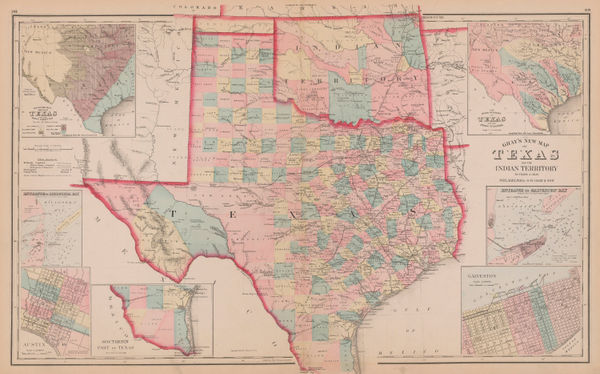
Justus Perthes, [Texasa and Indian Territory], 1876£ 385.00
-
Justus Perthes, Lt. Wheeler's Survey of California, Nevada & Arizona, 1876£ 375.00
-
Adrien Brue, Carte de L'Amerique Septentrionale, 1876£ 175.00
-
Citizens & Travelers Guide Map in, to, and from the City of New York and Adjacent Places, 1877D.A. EdsallSeries: New YorkD.A. Edsall, Citizens & Travelers Guide Map in, to, and from the City of New York and Adjacent Places, 1877£ 1,450.00
-
Justus Perthes, Southern California and Nevada, Arizona and western New Mexico, 1877£ 245.00
-
Atlantic Coast Pilot, Nantucket Sound, 1877£ 395.00
-
Frank Arnold Gray, Gray's New map of Alabama, 1878 c.£ 240.00
-
Frank Arnold Gray, Gray's New Map of Mississippi, 1878 c.£ 160.00
-
Frank Arnold Gray, Indiana, 1878 c.£ 140.00
-
Frank Arnold Gray, Pennsylvania, 1878 c.£ 140.00
-
Dawes Commission, Map of Indian Territory, 1879£ 775.00
-
Society for the Diffusion of Useful Knowledge (SDUK), North America, 1879£ 195.00
-
North America: Parts of Wisconsin and Michigan, 1879Society for the Diffusion of Useful Knowledge (SDUK)Series: LondonSociety for the Diffusion of Useful Knowledge (SDUK), North America: Parts of Wisconsin and Michigan, 1879£ 245.00
-
James Van Vechten, Park and Guide Map of Chicago, 1879£ 2,450.00
-
Society for the Diffusion of Useful Knowledge (SDUK), Florida, 1879£ 645.00
-
Samuel Augustus Mitchell, County and Township Map of Arizona and New Mexico, 1880£ 225.00
-
County and Township Map of the States of New Hampshire and Vermont, 1880Samuel Augustus MitchellSeries: PhiladelphiaSamuel Augustus Mitchell, County and Township Map of the States of New Hampshire and Vermont, 1880£ 120.00
-
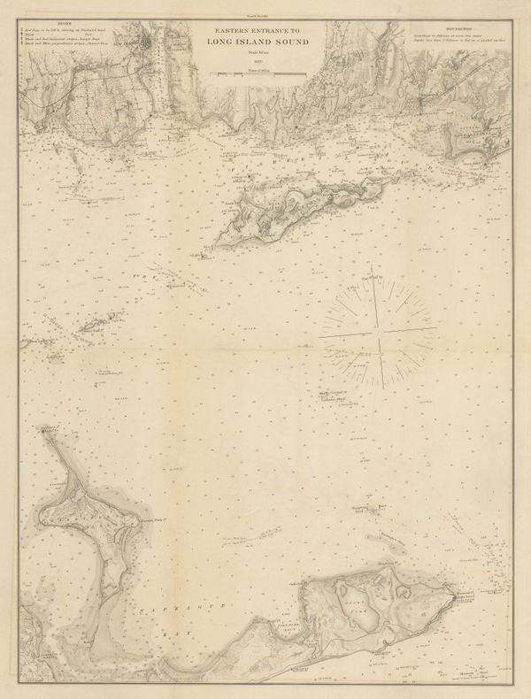
Atlantic Coast Pilot, Eastern Entrance to Long Island Sound, 1880£ 245.00
-
Coast of Rhode Island from Cuttyhunk to Point Judith, 1880Atlantic Coast PilotSeries: Washington, D.C.Atlantic Coast Pilot, Coast of Rhode Island from Cuttyhunk to Point Judith, 1880£ 325.00
-
Atlantic Coast Pilot, Long Island Sound, 1880£ 225.00
-
Atlantic Coast Pilot, Long Island Sound, 1880£ 245.00
-
North America Sheet XI - Parts of North and South Carolina, 1880Society for the Diffusion of Useful Knowledge (SDUK)Series: LondonSociety for the Diffusion of Useful Knowledge (SDUK), North America Sheet XI - Parts of North and South Carolina, 1880£ 80.00
-
Justus Perthes, Texas, 1880£ 175.00
-
W. & A.K. Johnston, Wisconsin, 1880 (c.)£ 65.00
-
W. & A.K. Johnston, Tennessee, 1880 (c.)£ 65.00
-
W. & A.K. Johnston, Vermont, 1880 (c.)£ 75.00
-
W. & A.K. Johnston, Minnesota, 1880 (c.)£ 85.00
-
W. & A.K. Johnston, California, 1880 c.£ 95.00
-
Blackie & Son, The United States of North America, 1880 c.£ 125.00
-
Cassell & Company, New York and Environs, 1880 c.£ 82.00
-
Arthème Fayard, New York, 1880 c.£ 275.00
-
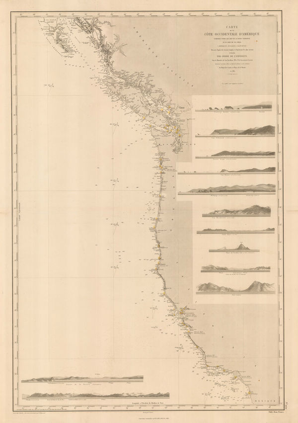
French Admiralty, Chart of the west coast of North America, 1881£ 825.00
-
Samuel Augustus Mitchell, County and Township Map of Utah and Nevada, 1881£ 120.00
-
J.A. & R.A. Reid, Index Map of the City of Providence, R.I., 1881£ 745.00
-
-
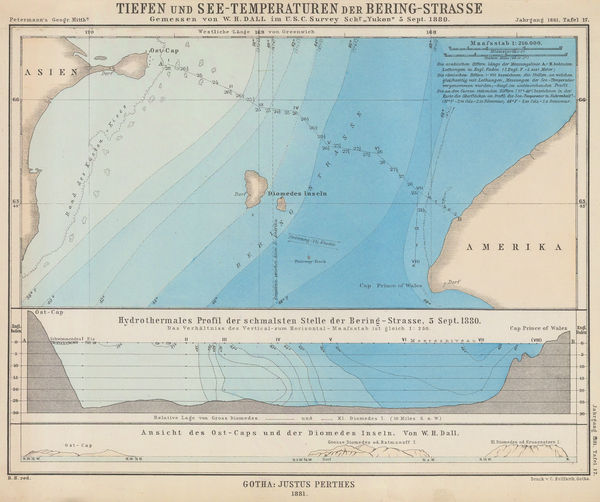
Justus Perthes, Bering Strait, 1881£ 115.00
-
O.W. Gray & Son, New Map of the United States, 1881£ 385.00
-
O.W. Gray & Son, Minnesota, 1881£ 545.00
-
O.W. Gray & Son, Philadelphia, 1881£ 650.00
-
O.W. Gray & Son, North and South Carolina, 1881£ 495.00
-
O.W. Gray & Son, Maryland, Delaware and the District of Columbia, 1881£ 585.00
-
O.W. Gray & Son, Michigan, 1881£ 575.00
-
O.W. Gray & Son, Louisiana, 1881£ 395.00
-
O.W. Gray & Son, Texas and Indian Territory (Oklahoma), 1881£ 1,150.00
-
Rand McNally, California, 1881£ 545.00
-
O.W. Gray & Son, San Francisco, 1881£ 495.00


![Justus Perthes, [Texasa and Indian Territory], 1876](https://static-assets.artlogic.net/w_600,c_limit,f_auto,fl_lossy,q_auto/artlogicstorage/themaphouse/images/view/488afc00723c4bf1a468f344f17d5a4dj/themaphouse-justus-perthes-texasa-and-indian-territory-1876.jpg)


Page
9
of 16