-
 Perry Mason & Co., Arkansas, 1891£ 95.00
 -
Perry Mason & Co., Arizona, 1891£ 145.00
-
Perry Mason & Co., Alabama, 1891£ 95.00
-
Peter Roy, Bird's Eye View of Chicago, 1892£ 1,200.00
-
Letts & Son, City of Philadelphia, 1892£ 225.00
-
Letts & Son, Michigan, Wisconsin and Lake Michigan, 1892£ 95.00
-
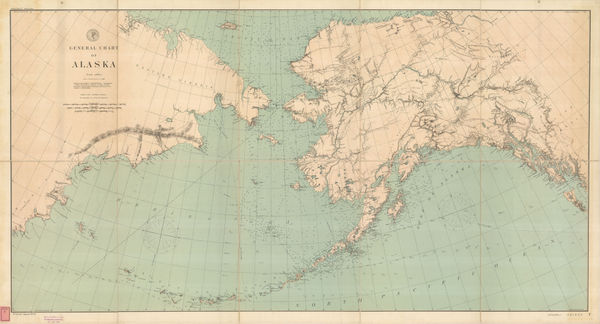
Thomas Corwin Mendenhall, General Chart of Alaska, 1892£ 1,275.00
-
John F. Murphy, Historical Map of Nantucket, 1892£ 695.00
-
Letts & Son, United States, 1892£ 65.00
-
Letts & Son, New York City, 1892£ 695.00
-
Rand, McNally & Co., Arizona, 1892£ 275.00
-
Rufus Blanchard, Map of the Business and Central Portions of Chicago, 1893£ 1,250.00
-
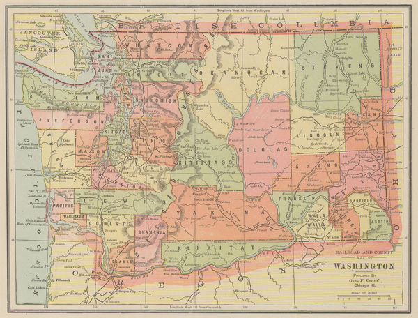
Eugenia & Henry Goff, Railroad and County Map of Washington, 1893£ 36.00
-
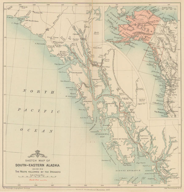
Scottish Geographical Society (SGS), Sketch Map of South-Eastern Alaska, 1893£ 98.00
-
American Civil War, Coast of Texas and its Defences, 1894£ 495.00
-
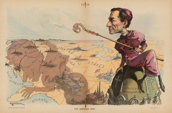
Keppler and Schwarzmann, The American Pope, 1894£ 1,900.00
-
American Civil War, Southern Texas, 1894£ 245.00
-
George H. Walker & Co, Official Map of Boston, 1895£ 645.00
-
British Admiralty, Sea Chart of the California Coast, 1895£ 750.00
-
British Admiralty, San Francisco Harbour, 1895£ 1,850.00
-
Rand, McNally & Co., Washington, 1895£ 495.00
-
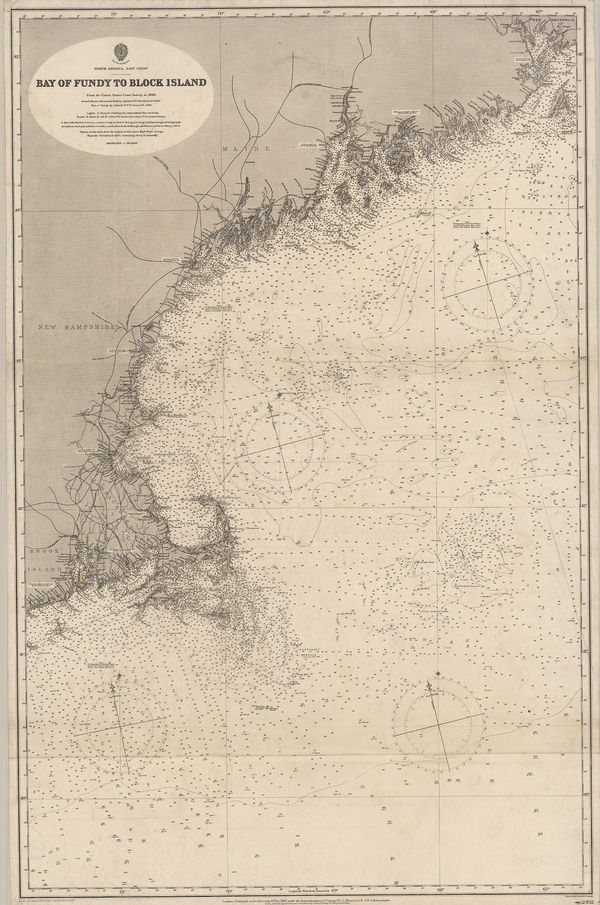
British Admiralty, Bay of Fundy to Block Island, 1896£ 2,150.00
-
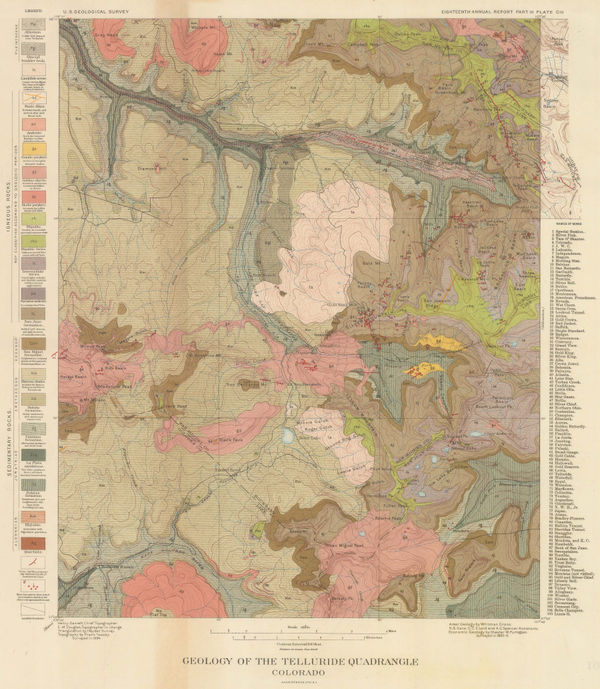
Geology of the Telluride Quadrangle Colorado, 1896United States Geological Survey (USGS)Series: New YorkUnited States Geological Survey (USGS), Geology of the Telluride Quadrangle Colorado, 1896£ 495.00
-
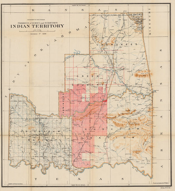
US Department of the Interior, Indian Territory, 1896£ 685.00
-
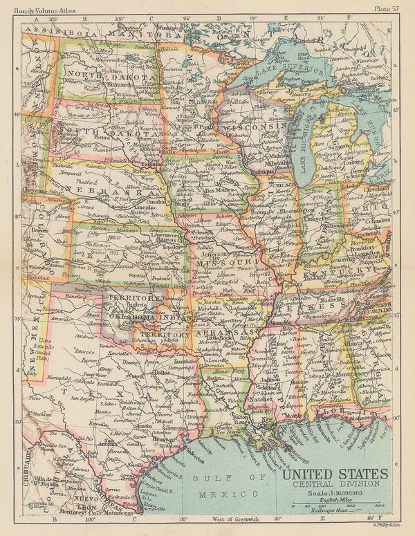
George Philip & Son Ltd., United States - Central Division, 1896£ 36.00
-
George Philip & Son Ltd., United States - Eastern Division, 1896£ 38.00
-
General Land Office (GLO), Territory of Arizona, 1896£ 950.00
-
Edward Stanford, Western United States, 1896£ 125.00
-
Edward Stanford, Ontario, Quebec, New Brunswick & Nova Scotia, 1896£ 95.00
-
Edwin Munroe Bacon, Map of the Country Southeast of Boston, 1896£ 195.00
-
Edwin Munroe Bacon, Map of the Country Northeast of Boston, 1896£ 195.00
-
George Cram, Arkansas, 1897£ 185.00
-
George Cram, California and Nevada Northern Half, 1897£ 225.00
-
Commercial Railroad and County Map of Massachusetts and Rhode Island, 1897George CramSeries: ChicagoGeorge Cram, Commercial Railroad and County Map of Massachusetts and Rhode Island, 1897£ 275.00
-
George Cram, Illinois, 1897£ 245.00
-
George Cram, Indiana, 1897£ 185.00
-
George Cram, Kansas, 1897£ 195.00
-
George Cram, Kentucky and Tennessee, 1897£ 185.00
-
George Cram, Kentucky Tennessee, 1897£ 195.00
-
George Cram, Maine, 1897£ 225.00
-
George Cram, Maryland and Delaware, 1897£ 295.00
-
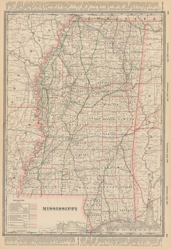
George Cram, Mississippi, 1897£ 185.00
-
George Cram, New Hampshire and Vermont, 1897£ 295.00
-
George Cram, New Jersey, 1897£ 245.00
-
George Cram, North & South Carolina, 1897£ 225.00
-
George Cram, North and South Carolina, 1897£ 225.00
-
George Cram, Ohio - North half, 1897£ 195.00
-
George Cram, Pennsylvania, 1897£ 165.00
-
Century Company, The Century Atlas - Kentucky, 1897£ 28.00
-
Century Company, The century Atlas - South Dakota, 1897£ 24.00
-
George Cram, Virginia and West Virginia, 1897£ 495.00
-
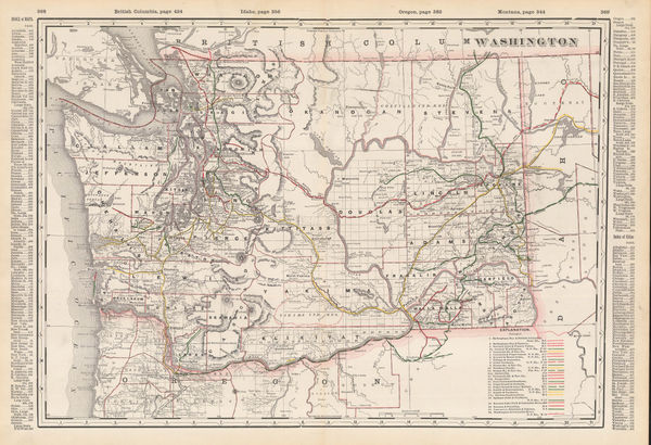
George Cram, Washington, 1897£ 225.00
-
George Cram, Western Part of Oregon / Eastern Part of Oregon, 1897£ 345.00
-
George Cram, Southern Ohio, 1897£ 195.00
-
Mast Crowell & Kirkpatrick, California and Nevada, 1897£ 195.00
-
George Cram, Georgia, 1897£ 275.00
-
George Cram, Railroad and County Map of Arizona, 1897£ 395.00
-
Walker Lith. & Pub. Co., Boston Harbor, 1897 c.£ 325.00
-
British Admiralty, Cape Fear to Sapelo Sound, 1898£ 2,500.00
-
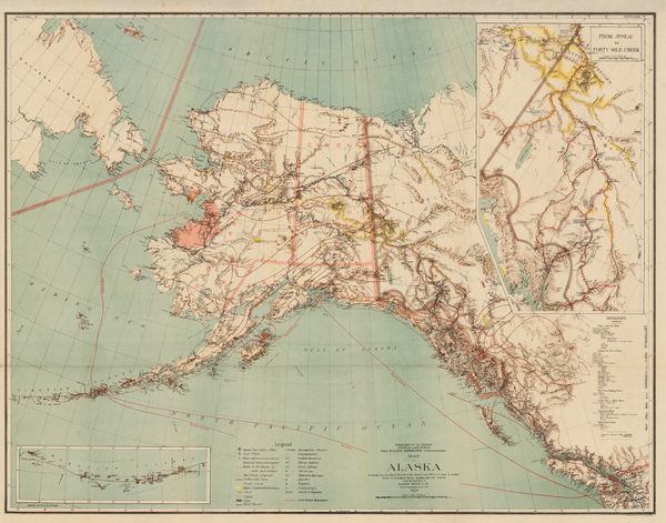
Harry King, Map of Alaska, 1898£ 645.00
-
A.H. Mueller, Map of the City of Cleveland, 1898£ 650.00
-
George Cram, Texas, 1898£ 485.00
-
The North-Western Part of the Dominion of Canada, 1898Royal Geographical Society (RGS)Series: LondonRoyal Geographical Society (RGS), The North-Western Part of the Dominion of Canada, 1898£ 495.00
-
Rand, McNally & Co., Washington, 1900£ 400.00
-
Rand McNally, New Map of New York City, 1900 (c.)£ 375.00
-
New Map, with compliments of the Broadway Central Hotel, 1900 c.Tilly HaynesSeries: Springfield, Mass.Tilly Haynes, New Map, with compliments of the Broadway Central Hotel, 1900 c.£ 175.00
-
George Cram, Idaho, 1900 c.£ 185.00
-
Where to Go and How to Get There Map of Colororado Springs and Colorado City, 1901Gilbert McClurgSeries: Colorado SpringsGilbert McClurg, Where to Go and How to Get There Map of Colororado Springs and Colorado City, 1901£ 445.00
-
British Admiralty, Sea Chart of Seattle & Tacoma, 1902£ 1,950.00
-
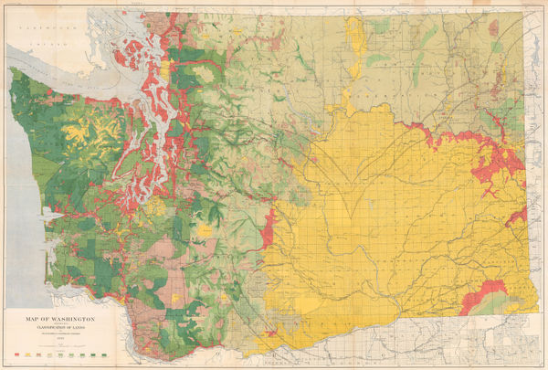
George Howard Plummer, Timber Map of Washington State, 1902£ 2,750.00
-
Kenyon Printing & Mfg. Co., Map of Colorado, 1902£ 275.00
-
Weyss, Map of the United States and Texas Boundary and adjacent Territory, 1902£ 775.00
-
Century Company, California Northern Part, 1902£ 75.00
-
Hawaiian Government Survey, Maui - Hawaiian Islands, 1903£ 3,450.00
-
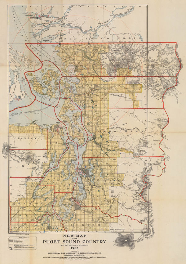
New Map of the Puget Sound Country - Seattle, 1903Bellingham Bay Abstract & Title Insurance Co.Series: WashingtonBellingham Bay Abstract & Title Insurance Co., New Map of the Puget Sound Country - Seattle, 1903£ 1,950.00
-
Rand, McNally & Co., Oregon, 1903£ 395.00
-
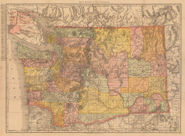
Rand, McNally & Co., Washington, 1903£ 445.00
-
Emil Reich, The Seven Years' War in Europe and America, 1903£ 65.00
-
Dawes Commission, Creek & Seminole Nations, Indian Territory, 1904£ 375.00
-
Dawes Commission, Indian Territory Showing Railroad Systems, 1904£ 225.00


Page
12
of 16